Narrow Results By
Subject
- Advertising Medium - Signs and Signboards 5
- Agricultural Tools and Equipment - Gardening Equipment 1
- Agriculture - Crops 4
- Agriculture - Farms 5
- Agriculture - Orchards 1
- Animals 1
- Animals - Cows 1
- Animals - Dogs 1
- Animals - Horses 1
- Animals - Poultry 3
- Buildings - Commercial 1
- Buildings - Commercial - Drugstores 1
Creator
- Barrowclough, G.A. 2
- Barrowclough, George Alfred 3
- Brown, William Thomas 2
- Burnett and McGugan B.C. Land Surveyors, New Westminster 1
- Burnett & McGugan, Engineers and Surveyors 1
- Disney, John Harold "Jack" 3
- Hill, Albert James 1
- J.C. Allen 1
- John Reid 1
- McGugan, Donald Johnston 2
- Phillips, James William "Jim" 1
- Robert Lyon 1
![Gordon Presbyterian Church Refreshment Building, [1918] (date of original), copied 1987 thumbnail](/media/hpo/_Data/_Archives_Images/_Unrestricted/126/193-003.jpg?width=280)
Gordon Presbyterian Church Refreshment Building
https://search.heritageburnaby.ca/link/archivedescription35102
- Repository
- City of Burnaby Archives
- Date
- [1918] (date of original), copied 1987
- Collection/Fonds
- Burnaby Historical Society fonds
- Description Level
- Item
- Physical Description
- 1 photograph : b&w ; 8.8 x 12.5 cm print
- Scope and Content
- Photograph of the exterior of the Gordon Presbyterian Church refreshment building at the Central Park Agricultural Exhibition. Signs on the building read, "Gordon Presby Church," "Continuous Performance," "This is the Best," "Home Cooking / [illegible] just like Mother's / [Smells?] Good! Tastes B…
- Repository
- City of Burnaby Archives
- Date
- [1918] (date of original), copied 1987
- Collection/Fonds
- Burnaby Historical Society fonds
- Subseries
- Gordon Presbyterian Church subseries
- Physical Description
- 1 photograph : b&w ; 8.8 x 12.5 cm print
- Description Level
- Item
- Record No.
- 193-003
- Access Restriction
- No restrictions
- Reproduction Restriction
- No known restrictions
- Accession Number
- BHS1987-02
- Scope and Content
- Photograph of the exterior of the Gordon Presbyterian Church refreshment building at the Central Park Agricultural Exhibition. Signs on the building read, "Gordon Presby Church," "Continuous Performance," "This is the Best," "Home Cooking / [illegible] just like Mother's / [Smells?] Good! Tastes Better!," "Place to Dine," and "Hot Meals." Three women and a boy are outside the building.
- Subjects
- Exhibitions - Agricultural
- Buildings - Commercial - Restaurants
- Advertising Medium - Signs and Signboards
- Media Type
- Photograph
- Notes
- Title based on contents of photograph
- Geographic Access
- Central Park
- Imperial Street
- Street Address
- 3883 Imperial Street
- Historic Neighbourhood
- Central Park (Historic Neighbourhood)
- Planning Study Area
- Maywood Area
Images
![Gordon Presbyterian Church Refreshment Building, [1918] (date of original), copied 1987 thumbnail](/media/hpo/_Data/_Archives_Images/_Unrestricted/126/193-003.jpg)
![Gordon Presbyterian Church Refreshment Tent, [1912] (date of original), copied 1987 thumbnail](/media/hpo/_Data/_Archives_Images/_Unrestricted/126/193-001.jpg?width=280)
Gordon Presbyterian Church Refreshment Tent
https://search.heritageburnaby.ca/link/archivedescription35100
- Repository
- City of Burnaby Archives
- Date
- [1912] (date of original), copied 1987
- Collection/Fonds
- Burnaby Historical Society fonds
- Description Level
- Item
- Physical Description
- 1 photograph : b&w ; 8.8 x 12.5 cm print
- Scope and Content
- Photograph of the exterior of the Gordon Presbyterian Church refreshment tent at the Central Park Agricultural Exhibition. Banners above the door of the tent read, "Gordon Presby Church Refreshments" and "Hot Meals." Other banners and penants read, "God Save the King" and "Canada." Nine women an…
- Repository
- City of Burnaby Archives
- Date
- [1912] (date of original), copied 1987
- Collection/Fonds
- Burnaby Historical Society fonds
- Subseries
- Gordon Presbyterian Church subseries
- Physical Description
- 1 photograph : b&w ; 8.8 x 12.5 cm print
- Description Level
- Item
- Record No.
- 193-001
- Access Restriction
- No restrictions
- Reproduction Restriction
- No known restrictions
- Accession Number
- BHS1987-02
- Scope and Content
- Photograph of the exterior of the Gordon Presbyterian Church refreshment tent at the Central Park Agricultural Exhibition. Banners above the door of the tent read, "Gordon Presby Church Refreshments" and "Hot Meals." Other banners and penants read, "God Save the King" and "Canada." Nine women and two men are standing outside the tent. The women are wearing aprons. There is an automobile parked on the right side of the photograph.
- Subjects
- Buildings - Commercial - Restaurants
- Advertising Medium - Signs and Signboards
- Structures - Tents
- Media Type
- Photograph
- Notes
- Title based on contents of photograph
- Geographic Access
- Central Park
- Imperial Street
- Street Address
- 3883 Imperial Street
- Historic Neighbourhood
- Central Park (Historic Neighbourhood)
- Planning Study Area
- Maywood Area
Images
![Gordon Presbyterian Church Refreshment Tent, [1912] (date of original), copied 1987 thumbnail](/media/hpo/_Data/_Archives_Images/_Unrestricted/126/193-001.jpg)
![Gordon Presbyterian Church Refreshment Tent, [1912] (date of original), copied 1987 thumbnail](/media/hpo/_Data/_Archives_Images/_Unrestricted/126/193-002.jpg?width=280)
Gordon Presbyterian Church Refreshment Tent
https://search.heritageburnaby.ca/link/archivedescription35101
- Repository
- City of Burnaby Archives
- Date
- [1912] (date of original), copied 1987
- Collection/Fonds
- Burnaby Historical Society fonds
- Description Level
- Item
- Physical Description
- 1 photograph : b&w ; 8.7 x 12.4 cm print
- Scope and Content
- Photograph of the exterior of the Gordon Presbyterian Church refreshment tent at the Central Park Agricultural Exhibition. A sign above the door of the tent reads, "Gordon Presby Church Refreshments." Eight women and two men are standing outside the tent. The women are wearing aprons. Pennants …
- Repository
- City of Burnaby Archives
- Date
- [1912] (date of original), copied 1987
- Collection/Fonds
- Burnaby Historical Society fonds
- Subseries
- Gordon Presbyterian Church subseries
- Physical Description
- 1 photograph : b&w ; 8.7 x 12.4 cm print
- Description Level
- Item
- Record No.
- 193-002
- Access Restriction
- No restrictions
- Reproduction Restriction
- No known restrictions
- Accession Number
- BHS1987-02
- Scope and Content
- Photograph of the exterior of the Gordon Presbyterian Church refreshment tent at the Central Park Agricultural Exhibition. A sign above the door of the tent reads, "Gordon Presby Church Refreshments." Eight women and two men are standing outside the tent. The women are wearing aprons. Pennants on the tent read, "Canada."
- Subjects
- Buildings - Commercial - Restaurants
- Advertising Medium - Signs and Signboards
- Structures - Tents
- Media Type
- Photograph
- Notes
- Title based on contents of photograph
- Geographic Access
- Central Park
- Imperial Street
- Street Address
- 3883 Imperial Street
- Historic Neighbourhood
- Central Park (Historic Neighbourhood)
- Planning Study Area
- Maywood Area
Images
![Gordon Presbyterian Church Refreshment Tent, [1912] (date of original), copied 1987 thumbnail](/media/hpo/_Data/_Archives_Images/_Unrestricted/126/193-002.jpg)
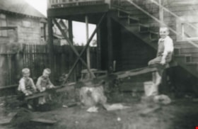
Grant family
https://search.heritageburnaby.ca/link/archivedescription36867
- Repository
- City of Burnaby Archives
- Date
- 1914 (date of original), copied 1992
- Collection/Fonds
- Burnaby Historical Society fonds
- Description Level
- Item
- Physical Description
- 1 photograph : b&w ; 8.3 x 12.7 cm print
- Scope and Content
- Photograph of the Grant brothers; eldest Bill, (above), with George and Harry on a teeter totter outside the family home at 2540 Marlborough Avenue (renumbered 6591 Marlborough Avenue).
- Repository
- City of Burnaby Archives
- Date
- 1914 (date of original), copied 1992
- Collection/Fonds
- Burnaby Historical Society fonds
- Subseries
- Burnaby Centennial Anthology subseries
- Physical Description
- 1 photograph : b&w ; 8.3 x 12.7 cm print
- Description Level
- Item
- Record No.
- 315-325
- Access Restriction
- No restrictions
- Reproduction Restriction
- No known restrictions
- Accession Number
- BHS1994-04
- Scope and Content
- Photograph of the Grant brothers; eldest Bill, (above), with George and Harry on a teeter totter outside the family home at 2540 Marlborough Avenue (renumbered 6591 Marlborough Avenue).
- Media Type
- Photograph
- Notes
- Title based on contents of photograph
- Geographic Access
- Marlborough Avenue
- Street Address
- 6591 Marlborough Avenue
- Historic Neighbourhood
- Central Park (Historic Neighbourhood)
- Planning Study Area
- Marlborough Area
Images

![Grimmer family, [1918] thumbnail](/media/hpo/_Data/_Archives_Images/_Unrestricted/251/290-004.jpg?width=280)
Grimmer family
https://search.heritageburnaby.ca/link/archivedescription36534
- Repository
- City of Burnaby Archives
- Date
- [1918]
- Collection/Fonds
- Burnaby Historical Society fonds
- Description Level
- Item
- Physical Description
- 1 photograph : b&w ; 9 x 12.5 cm
- Scope and Content
- Photograph of Lancelot and Martha Jane Grimmer standing together in their yard.
- Repository
- City of Burnaby Archives
- Date
- [1918]
- Collection/Fonds
- Burnaby Historical Society fonds
- Subseries
- Grimmer family subseries
- Physical Description
- 1 photograph : b&w ; 9 x 12.5 cm
- Description Level
- Item
- Record No.
- 290-004
- Access Restriction
- No restrictions
- Reproduction Restriction
- No known restrictions
- Accession Number
- BHS1992-26
- Scope and Content
- Photograph of Lancelot and Martha Jane Grimmer standing together in their yard.
- Media Type
- Photograph
- Notes
- Title based on contents of photograph
- Geographic Access
- Grimmer Street
- Historic Neighbourhood
- Central Park (Historic Neighbourhood)
- Planning Study Area
- Windsor Area
Images
![Grimmer family, [1918] thumbnail](/media/hpo/_Data/_Archives_Images/_Unrestricted/251/290-004.jpg)

Harry and Hannah Sellers
https://search.heritageburnaby.ca/link/archivedescription35236
- Repository
- City of Burnaby Archives
- Date
- 1917 (date of original), copied 1986
- Collection/Fonds
- Burnaby Historical Society fonds
- Description Level
- Item
- Physical Description
- 1 photograph : b&w ; 12.7 x 17.8 cm print
- Scope and Content
- Photograph of Harry Sellers and wife Hannah Sellers, with other family members. They rented this house at Imperial Street and Royal Oak for $10.00 per month after being married. Rent was raised to $12.00 during the next six years. They moved into their own home in 1923.
- Repository
- City of Burnaby Archives
- Date
- 1917 (date of original), copied 1986
- Collection/Fonds
- Burnaby Historical Society fonds
- Subseries
- Pioneer Tales subseries
- Physical Description
- 1 photograph : b&w ; 12.7 x 17.8 cm print
- Description Level
- Item
- Record No.
- 204-093
- Access Restriction
- No restrictions
- Reproduction Restriction
- No known restrictions
- Accession Number
- BHS1988-03
- Scope and Content
- Photograph of Harry Sellers and wife Hannah Sellers, with other family members. They rented this house at Imperial Street and Royal Oak for $10.00 per month after being married. Rent was raised to $12.00 during the next six years. They moved into their own home in 1923.
- Subjects
- Buildings - Residential - Houses
- Media Type
- Photograph
- Notes
- Title based on contents of photograph
- Geographic Access
- Royal Oak Avenue
- Street Address
- 6756 Royal Oak Avenue
- Historic Neighbourhood
- Central Park (Historic Neighbourhood)
- Planning Study Area
- Windsor Area
Images
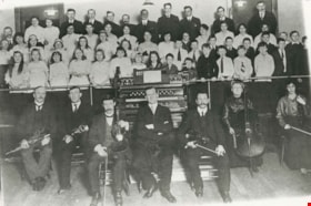
Henderson Presbyterian Church Choir and Orchestra
https://search.heritageburnaby.ca/link/archivedescription35174
- Repository
- City of Burnaby Archives
- Date
- December 16, 1915 (date of original), copied 1986
- Collection/Fonds
- Burnaby Historical Society fonds
- Description Level
- Item
- Physical Description
- 1 photograph : b&w ; 12.7 x 17.8 cm print
- Scope and Content
- Photograph of the choir and orchestra at Henderson Presbyterian Church, West Burnaby. Thomas Shankie is in front of the organ.
- Repository
- City of Burnaby Archives
- Date
- December 16, 1915 (date of original), copied 1986
- Collection/Fonds
- Burnaby Historical Society fonds
- Subseries
- Pioneer Tales subseries
- Physical Description
- 1 photograph : b&w ; 12.7 x 17.8 cm print
- Description Level
- Item
- Record No.
- 204-031
- Access Restriction
- No restrictions
- Reproduction Restriction
- No known restrictions
- Accession Number
- BHS1988-03
- Scope and Content
- Photograph of the choir and orchestra at Henderson Presbyterian Church, West Burnaby. Thomas Shankie is in front of the organ.
- Subjects
- Organizations - Choirs
- Performances - Concerts
- Musical Instruments
- Occupations - Musicians
- Organizations - Orchestras
- Media Type
- Photograph
- Notes
- Title based on contents of photograph
- Geographic Access
- Sussex Avenue
- Street Address
- 6050 Sussex Avenue
- Historic Neighbourhood
- Central Park (Historic Neighbourhood)
- Planning Study Area
- Marlborough Area
Images
Holmes family
https://search.heritageburnaby.ca/link/archivedescription35751
- Repository
- City of Burnaby Archives
- Date
- 1916 (date of original), copied 1986
- Collection/Fonds
- Burnaby Historical Society fonds
- Description Level
- Item
- Physical Description
- 1 photograph : b&w ; 12.7 x 17.8 cm print
- Scope and Content
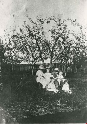
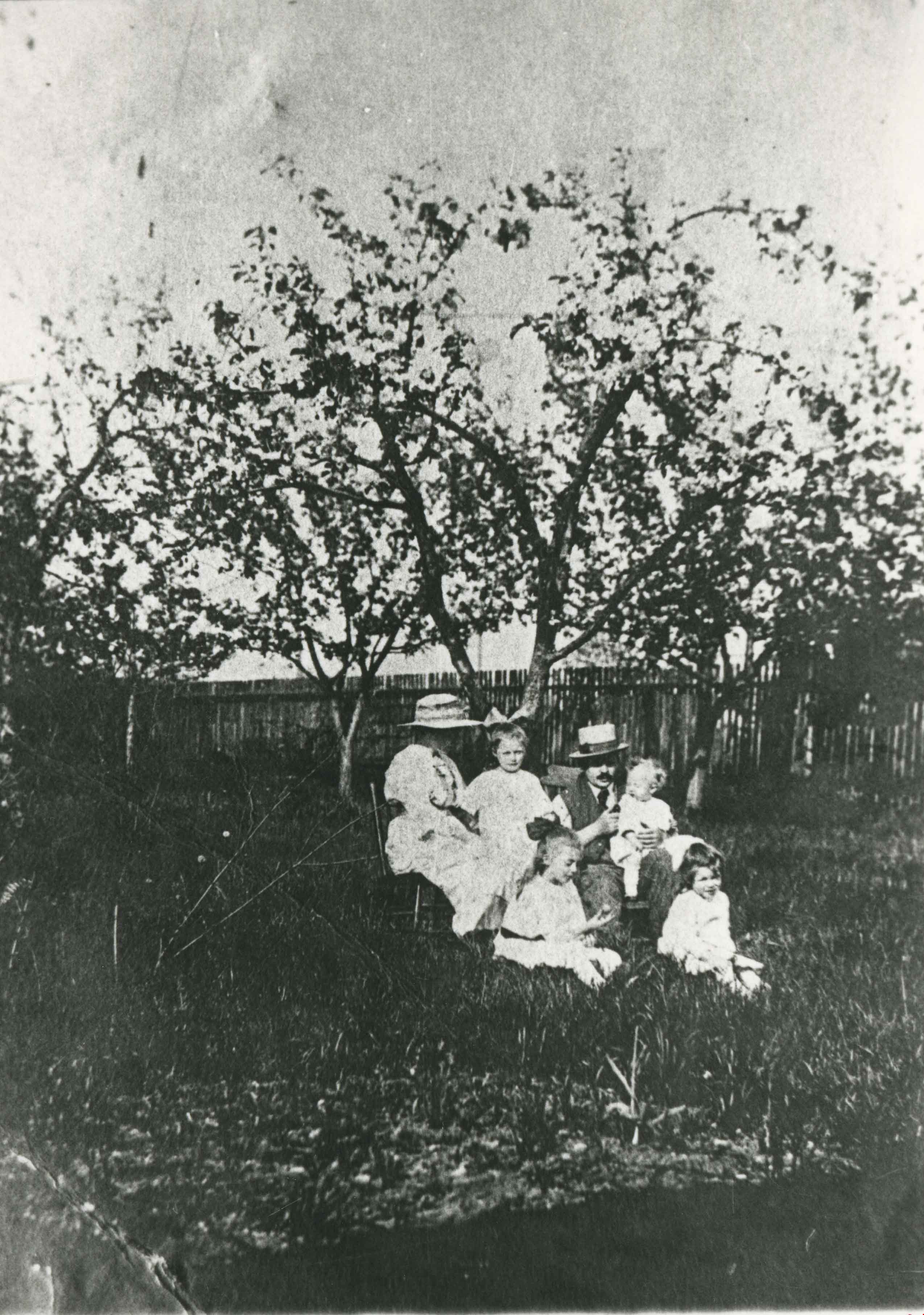
- Photograph of the Holmes family in the orchard of their rented home at Kingsway and Kathleen Avenue. Parents (left to right) Johnson "Jerry" Holmes (father) and Mrs. Cissie Holmes (mother). Children (left to right) Kathleen Holmes (sister), Eileen Holmes (sister), Mary Holmes (sister), and Harry …
- Repository
- City of Burnaby Archives
- Date
- 1916 (date of original), copied 1986
- Collection/Fonds
- Burnaby Historical Society fonds
- Subseries
- Pioneer Tales subseries
- Physical Description
- 1 photograph : b&w ; 12.7 x 17.8 cm print
- Description Level
- Item
- Record No.
- 204-609
- Access Restriction
- No restrictions
- Reproduction Restriction
- No known restrictions
- Accession Number
- BHS1988-03
- Scope and Content
- Photograph of the Holmes family in the orchard of their rented home at Kingsway and Kathleen Avenue. Parents (left to right) Johnson "Jerry" Holmes (father) and Mrs. Cissie Holmes (mother). Children (left to right) Kathleen Holmes (sister), Eileen Holmes (sister), Mary Holmes (sister), and Harry Holmes (brother).
- Subjects
- Agriculture - Orchards
- Names
- Baker, Kathleen Holmes
- Holmes, Alice Mary Harbottle "Cissie"
- Holmes, Eileen
- Holmes, Johnson "Jerry"
- Holmes, Mary
- Media Type
- Photograph
- Notes
- Title based on contents of photograph
- Geographic Access
- Kingsway
- Kathleen Avenue
- Historic Neighbourhood
- Central Park (Historic Neighbourhood)
- Planning Study Area
- Maywood Area
Images
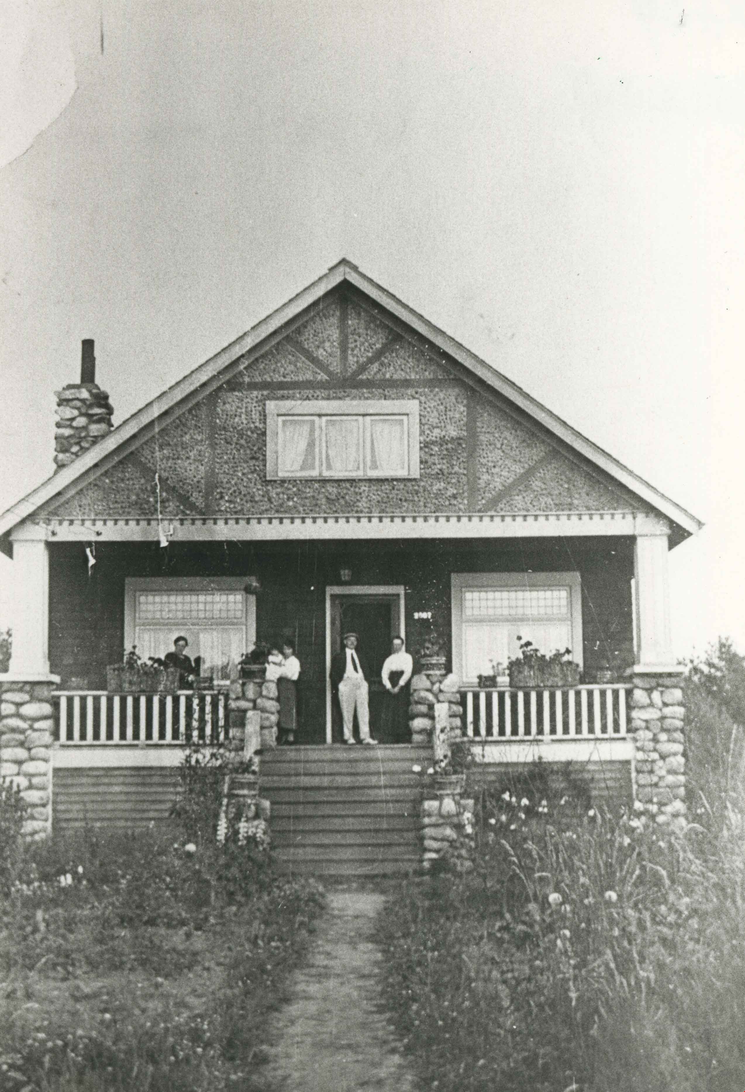
![Home of Arthur Lobley and his wife, [1915] thumbnail](/media/hpo/_Data/_BVM_Images/1976/1976_0236_0001_001.jpg?width=280)
Home of Arthur Lobley and his wife
https://search.heritageburnaby.ca/link/museumdescription893
- Repository
- Burnaby Village Museum
- Date
- [1915]
- Collection/Fonds
- Burnaby Village Museum Photograph collection
- Description Level
- Item
- Physical Description
- 1 photograph : b&w postcard ; 9.0 x 13.9 cm
- Scope and Content
- Photographic postcard of a large three storey house with brick chimney and front balcony, with steps leading up to it. There are vegetable gardens around the house and a small tool shed on the left. There is an "x" marked on the left side of the photograph, with an annotation on the back reading: "…
- Repository
- Burnaby Village Museum
- Collection/Fonds
- Burnaby Village Museum Photograph collection
- Description Level
- Item
- Physical Description
- 1 photograph : b&w postcard ; 9.0 x 13.9 cm
- Scope and Content
- Photographic postcard of a large three storey house with brick chimney and front balcony, with steps leading up to it. There are vegetable gardens around the house and a small tool shed on the left. There is an "x" marked on the left side of the photograph, with an annotation on the back reading: "This is one side of house; x where front baclony is." Another annotation on the back of the photograph reads: "Home of Mr. and Mrs. Arthur Lobley on Marlborough Ave. S. Burnaby (just off Kingsway). Lobley Park named after Mr. Lobley." Arthur Lobley is credited for opening the Royal Oak Road to the tram station at Royal Oak in 1897, in George Green's book, "History of Burnaby," pg. 134.
- Geographic Access
- Marlborough Avenue
- Kingsway
- Accession Code
- HV976.236.1
- Access Restriction
- No restrictions
- Reproduction Restriction
- No known restrictions
- Date
- [1915]
- Media Type
- Photograph
- Historic Neighbourhood
- Central Park (Historic Neighbourhood)
- Planning Study Area
- Marlborough Area
- Scan Resolution
- 600
- Scan Date
- 2023-06-27
- Notes
- Title based on contents of photograph
Images
![Home of Arthur Lobley and his wife, [1915] thumbnail](/media/hpo/_Data/_BVM_Images/1976/1976_0236_0001_001.jpg)
![Home of Richard and Clara Thorpe, [1911] thumbnail](/media/hpo/_Data/_BVM_Images/1990/199900610001.jpg?width=280)
Home of Richard and Clara Thorpe
https://search.heritageburnaby.ca/link/museumdescription1507
- Repository
- Burnaby Village Museum
- Date
- [1911]
- Collection/Fonds
- Burnaby Village Museum Photograph collection
- Description Level
- Item
- Physical Description
- 1 photograph : b&w ; 10x 14 cm, mounted on card 15 x 22.5 cm
- Scope and Content
- Photograph of the home of Richard and Clara Thorpe. Nancy Davis Allard is standing, holding baby Dorothy Thorp (later Spain) upright in a buggy at the foot of the stairs. Two unidentified woman are also visible sitting at the top of the stairs.
- Repository
- Burnaby Village Museum
- Collection/Fonds
- Burnaby Village Museum Photograph collection
- Description Level
- Item
- Physical Description
- 1 photograph : b&w ; 10x 14 cm, mounted on card 15 x 22.5 cm
- Scope and Content
- Photograph of the home of Richard and Clara Thorpe. Nancy Davis Allard is standing, holding baby Dorothy Thorp (later Spain) upright in a buggy at the foot of the stairs. Two unidentified woman are also visible sitting at the top of the stairs.
- Subjects
- Buildings - Residential - Houses
- Geographic Access
- Boundary Road
- Burke Street
- Accession Code
- BV999.61.1
- Access Restriction
- No restrictions
- Date
- [1911]
- Media Type
- Photograph
- Historic Neighbourhood
- Central Park (Historic Neighbourhood)
- Planning Study Area
- Garden Village Area
- Scan Resolution
- 600
- Scan Date
- 09-Jun-09
- Scale
- 100
- Notes
- Title based on contents of photograph
- Note in blue ink on verso of photograph reads: "Home of Richard and/ Clara Thorp - about 1911./ Built in 1907. Boundary/ & Burke St. - Burnaby/ I'm in the buggy, held upright by my/ dear friend Nance -"
Images
![Home of Richard and Clara Thorpe, [1911] thumbnail](/media/hpo/_Data/_BVM_Images/1990/199900610001.jpg)

Hopper family
https://search.heritageburnaby.ca/link/archivedescription35081
- Repository
- City of Burnaby Archives
- Date
- 1912 (date of original), copied 1986
- Collection/Fonds
- Burnaby Historical Society fonds
- Description Level
- Item
- Physical Description
- 1 photograph : b&w ; 12.5 x 8.8 cm print
- Scope and Content
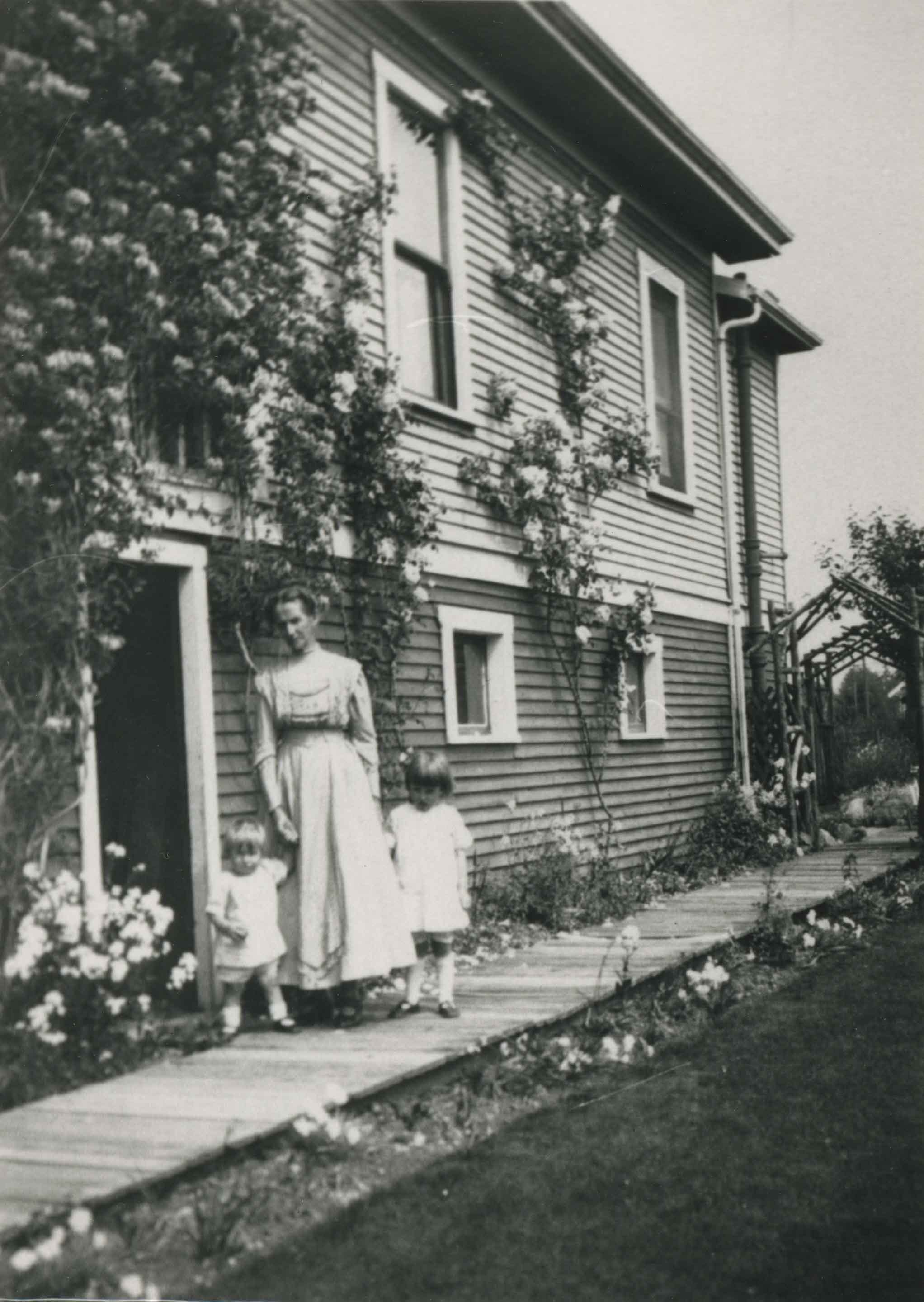
- Photograph of Mrs. Hopper and her grandchildren, Betty and Lois Atkinson, in the sideyard of a house on Kathleen Avenue. They are standing on a board sidewalk, and the flowers surrounding the house are in bloom.
- Repository
- City of Burnaby Archives
- Date
- 1912 (date of original), copied 1986
- Collection/Fonds
- Burnaby Historical Society fonds
- Subseries
- Davies family subseries
- Physical Description
- 1 photograph : b&w ; 12.5 x 8.8 cm print
- Description Level
- Item
- Record No.
- 190-001
- Access Restriction
- No restrictions
- Reproduction Restriction
- No known restrictions
- Accession Number
- BHS1986-41
- Scope and Content
- Photograph of Mrs. Hopper and her grandchildren, Betty and Lois Atkinson, in the sideyard of a house on Kathleen Avenue. They are standing on a board sidewalk, and the flowers surrounding the house are in bloom.
- Media Type
- Photograph
- Notes
- Title based on contents of photograph
- Geographic Access
- Kathleen Avenue
- Historic Neighbourhood
- Central Park (Historic Neighbourhood)
- Planning Study Area
- Maywood Area
Images
House on Imperial Street
https://search.heritageburnaby.ca/link/archivedescription36403
- Repository
- City of Burnaby Archives
- Date
- 1912
- Collection/Fonds
- Burnaby Historical Society fonds
- Description Level
- Item
- Physical Description
- 1 photograph : sepia ;16.5 x 12.5 cm, mounted on board 25 x 19.5 cm
- Scope and Content
- Photograph of a house on Imperial Street between Jubilee Avenue and Nelson Avenue. Handwritten on the back of the photorgaph's mount reads the following: "House on Imperial Street, Burnaby, (between Jubliee Avenue and Nelson) built in 1911-1912 for Rev. Hector N. Maclean, (first Minister of Hender…
- Repository
- City of Burnaby Archives
- Date
- 1912
- Collection/Fonds
- Burnaby Historical Society fonds
- Subseries
- Photographs subseries
- Physical Description
- 1 photograph : sepia ;16.5 x 12.5 cm, mounted on board 25 x 19.5 cm
- Description Level
- Item
- Record No.
- 262-001
- Access Restriction
- No restrictions
- Reproduction Restriction
- No known restrictions
- Accession Number
- BHS1991-27
- Scope and Content
- Photograph of a house on Imperial Street between Jubilee Avenue and Nelson Avenue. Handwritten on the back of the photorgaph's mount reads the following: "House on Imperial Street, Burnaby, (between Jubliee Avenue and Nelson) built in 1911-1912 for Rev. Hector N. Maclean, (first Minister of Henderson Presbyterian Church). We, the Maclean family, moved into the new house in early spring of 1912, shortly after the death of the eldest boy Hector (Teddy) on March / 13, 1912. Dr. & Mrs. Maclean & family moved to Victoria in 1914. The family moved to Vancouver in 1923 and Dr. Maclean served on the staff of the Social Services & Evangelism of the Presbyterian (?) [sic] of Canada as Assembly Evangelist. Dr. and Mrs. Maclean & youngest daughter went to New Zeland twice over a period of six years where he had several pastorales. On returning to Canada he returned to West Point Grey. Dr. & Mrs. Maclean had 10 children, 5 boys and five girls. Dr. maclean died on Jan. 20, 1950. / (Victoria - St. Paul's Presbyterian church) This brief account started by the eldest daughter Florence (Mrs. R.F. Mackenzie) and finished by the youngest daughter Marion (Mrs. A.K. Lovick of New Westminister) in August 1991. There is one remaining brother Donald Noble Maclean of Vancouver".
- Subjects
- Buildings - Residential - Houses
- Media Type
- Photograph
- Notes
- Title based on contents of photograph
- Stamp on recto of board reads: "Kinnee, Photo"
- Geographic Access
- Imperial Street
- Historic Neighbourhood
- Central Park (Historic Neighbourhood)
- Planning Study Area
- Marlborough Area
Images


Inauguration of the water system at Burnaby
https://search.heritageburnaby.ca/link/archivedescription35938
- Repository
- City of Burnaby Archives
- Date
- July 16, 1912
- Collection/Fonds
- Burnaby Historical Society fonds
- Description Level
- Item
- Physical Description
- 1 photograph : b&w postcard ; 8.9 x 14.0 cm
- Scope and Content
- Photographic postcard of Reeve Weart addressing a crowd gathered around the bandstand in Central Park for the inauguration of Burnaby Water Works. The Reeve is standing as he looks towards the crowd. Other men are seated in a semi-circle inside the bandstand. This was known as "Splash Day."
- Repository
- City of Burnaby Archives
- Date
- July 16, 1912
- Collection/Fonds
- Burnaby Historical Society fonds
- Subseries
- Pioneer Tales subseries
- Physical Description
- 1 photograph : b&w postcard ; 8.9 x 14.0 cm
- Description Level
- Item
- Record No.
- 204-798
- Access Restriction
- No restrictions
- Reproduction Restriction
- No known restrictions
- Accession Number
- BHS1988-03
- Scope and Content
- Photographic postcard of Reeve Weart addressing a crowd gathered around the bandstand in Central Park for the inauguration of Burnaby Water Works. The Reeve is standing as he looks towards the crowd. Other men are seated in a semi-circle inside the bandstand. This was known as "Splash Day."
- Subjects
- Buildings - Recreational - Bandstands
- Persons - Crowds
- Officials - Mayors and Reeves
- Public Services - Utilities
- Public Services - Public Works
- Documentary Artifacts - Postcards
- Names
- Weart, R.W.
- Media Type
- Photograph
- Notes
- 1 b&w copy negative accompanying
- Annotation of back of postcard reads, "July 16 - 1912 / Inauguration of the water system at Burnaby"
- Geographic Access
- Central Park
- Imperial Street
- Street Address
- 3883 Imperial Street
- Historic Neighbourhood
- Central Park (Historic Neighbourhood)
- Planning Study Area
- Maywood Area
Images


Inman Avenue School site
https://search.heritageburnaby.ca/link/museumdescription11128
- Repository
- Burnaby Village Museum
- Date
- May 3, 1915
- Collection/Fonds
- Ronald G. Scobbie collection
- Description Level
- Item
- Physical Description
- 1 survey plan : blueprint on paper ; 56 x 54 cm
- Scope and Content
- Survey plan of "Inman Avenue School Site" "Burnaby Municipality" "Being Lots 3 -12 inc. Blk. C. of Subd. of Blks.5" "13-19 inc. & 21-28 inc. of Subd. of Westerly 80 Acres of, and portion of D.L. 34, Group One. New Westminster District".
- Repository
- Burnaby Village Museum
- Collection/Fonds
- Ronald G. Scobbie collection
- Description Level
- Item
- Physical Description
- 1 survey plan : blueprint on paper ; 56 x 54 cm
- Material Details
- Scale: 40 feet = 1 inch
- Scope and Content
- Survey plan of "Inman Avenue School Site" "Burnaby Municipality" "Being Lots 3 -12 inc. Blk. C. of Subd. of Blks.5" "13-19 inc. & 21-28 inc. of Subd. of Westerly 80 Acres of, and portion of D.L. 34, Group One. New Westminster District".
- Creator
- McGugan, Donald Johnston
- Subjects
- Buildings - Schools
- Names
- Inman Avenue School
- Responsibility
- Burnett & McGugan, Engineers and Surveyors
- Geographic Access
- Brandon Street
- Street Address
- 3963 Brandon Street
- Accession Code
- BV003.83.7
- Access Restriction
- No restrictions
- Reproduction Restriction
- No known restrictions
- Date
- May 3, 1915
- Media Type
- Cartographic Material
- Historic Neighbourhood
- Central Park (Historic Neighbourhood)
- Planning Study Area
- Garden Village Area
- Scan Resolution
- 440
- Scan Date
- 22-Dec-2020
- Scale
- 100
- Notes
- Title based on contents of plan
- Oath in bottom left corner reads: "I, D.J. McGugan...did...superintend the survey...", "...completed on the 3rd day of May 1915"; signed "D.J. McGugan", notariz- ed by "Walter Edmonds" "sworn...22nd Day of May 1915"; "Burnett and McGugan. B.C. Land Surveyors. Etc. New Westminster. B.C.";
- handwritten note reads: "Note: Before using this Mon. see plan / of resubdivision of Lots 5 & 6 / of Block 'B' D.L. 34 / June 1945"
- handwritten twice on back, "1776"
Zoomable Images

Inman School Class
https://search.heritageburnaby.ca/link/archivedescription35218
- Repository
- City of Burnaby Archives
- Date
- 1912 (date of original), copied 1986
- Collection/Fonds
- Burnaby Historical Society fonds
- Description Level
- Item
- Physical Description
- 1 photograph : b&w ; 12.7 x 17.8 cm print
- Scope and Content
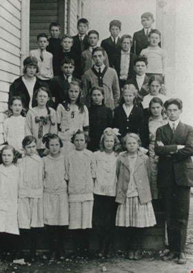
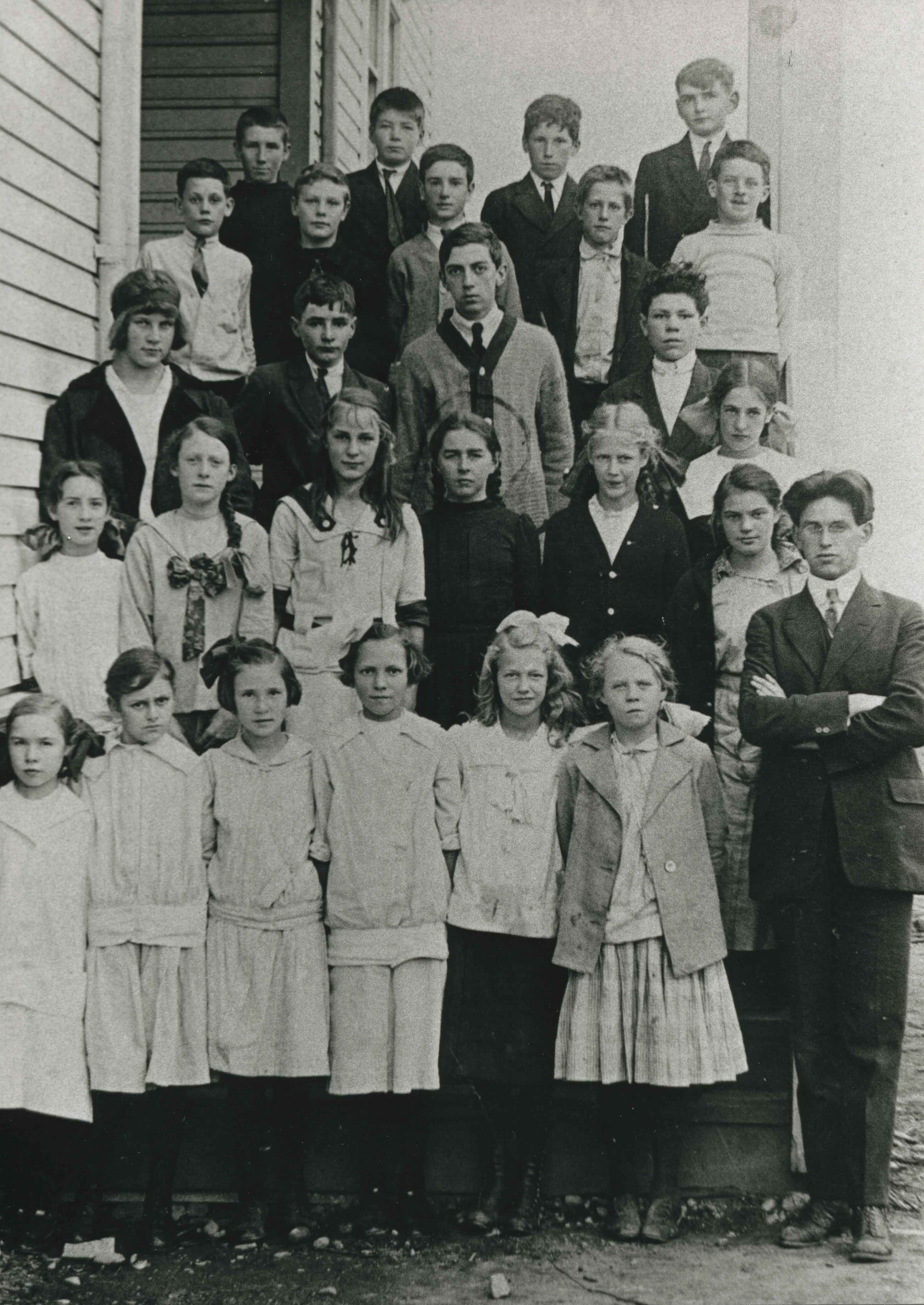
- Photograph of Inman Avenue School class. Marjorie Cassidy is in the 2nd row, 4th from left. The teacher, to the right, is Mr. Lowther. The Cassidy children, from oldest, are Willie, Marjorie, Mary and Katie.
- Repository
- City of Burnaby Archives
- Date
- 1912 (date of original), copied 1986
- Collection/Fonds
- Burnaby Historical Society fonds
- Subseries
- Pioneer Tales subseries
- Physical Description
- 1 photograph : b&w ; 12.7 x 17.8 cm print
- Description Level
- Item
- Record No.
- 204-075
- Access Restriction
- No restrictions
- Reproduction Restriction
- No known restrictions
- Accession Number
- BHS1988-03
- Scope and Content
- Photograph of Inman Avenue School class. Marjorie Cassidy is in the 2nd row, 4th from left. The teacher, to the right, is Mr. Lowther. The Cassidy children, from oldest, are Willie, Marjorie, Mary and Katie.
- Subjects
- Occupations - Teachers
- Media Type
- Photograph
- Notes
- Title based on contents of photograph
- Geographic Access
- Brandon Street
- Street Address
- 3963 Brandon Street
- Historic Neighbourhood
- Central Park (Historic Neighbourhood)
- Planning Study Area
- Garden Village Area
Images

Interview with W.H. O'Brien July / August 1975 - Track 1
https://search.heritageburnaby.ca/link/oralhistory18
- Repository
- City of Burnaby Archives
- Date Range
- 1914-1932
- Length
- 0:08:44
- Summary
- This portion of the interview pertains to W.H. "Harry" O'Brien's early childhood including the reasons why his family first moved to Burnaby, his first experiences of unemployment and what initially drew him to the Working Organization in Burnaby and their protest against evictions.
- Repository
- City of Burnaby Archives
- Summary
- This portion of the interview pertains to W.H. "Harry" O'Brien's early childhood including the reasons why his family first moved to Burnaby, his first experiences of unemployment and what initially drew him to the Working Organization in Burnaby and their protest against evictions.
- Date Range
- 1914-1932
- Photo Info
- Harry and Gertrude (Sutherland) O'Brien on their wedding day, October 12, 1940. Item no. 315-005
- Length
- 0:08:44
- Subjects
- Organizations
- Protests and Demonstrations
- Geographic Access
- Inman Avenue
- Historic Neighbourhood
- Central Park (Historic Neighbourhood)
- Interviewer
- Bradbury, Dr. Bettina
- Interview Date
- July / August 1975
- Scope and Content
- Recording is a taped interview with W.H. "Harry" O'Brien by SFU (Simon Fraser University) graduate student Bettina Bradbury. Major themes discussed are: the Army of the Common Good, the Union of the Unemployed and the Common Good Credit Union (now the South Burnaby Credit Union). To view "Narrow By" terms for each track expand this description and see "Notes".
- Biographical Notes
- W.H. “Harry” O’Brien was born in the coal mining town of Nanaimo, British Columbia on October 20, 1914. He came to Burnaby with his parents and five siblings in 1927. Harry’s mother, a school teacher, wanted her children to live closer to school in order to obtain a better education, so the O’Brien family settled at Inman Avenue, Burnaby. Harry's mother, Mary Anne Crossan, was Gilmore Avenue School's first teacher. Harry left school in June of 1929. Harry’s father worked as the caretaker at Central Park around this time and Harry helped him to clear brush, plant trees and enforce the land clearing and wood cutting permit regulations held by men who were on script. Although too young to vote by just over a week, Harry O'Brien worked as a scrutineer for the Co-operative Commonwealth Federation (CCF) during the 1935 Federal Election. On October 12, 1940 Harry O'Brien married Gertrude Sutherland at St. John the Divine in Burnaby. The Sutherland family came to Burnaby from Winnipeg in 1933 and settled at Nelson Avenue. Harry began his involvement with the Unemployment Organization in Burnaby by participating in an organised protest against the municipality for homeowner evictions brought on by unpaid taxes. The South Burnaby Union of the Unemployed organised in order to protest rules around receiving Relief. Harry became involved, eventually becoming one of the spearheads of the organization, taking over as secretary by 1936. Harry was an original member of the Army of the Common Good, helping to produce over one hundred and twenty-five tons of vegetables from its own gardens to feed Burnaby citizens suffering from the lack of resources during the Depression years. The members of the Army of the Common Good who cut wood for consumption or worked in the gardens were given credit for their work through LU (Labour Units) which they could then use to buy groceries and that at the Army's Cooperative stores, one of which was at McKay Avenue, where Harry began working as Manager of Groceries in 1937. The Credit Union movement of British Columbia was also organized by Harry O'Brien and his fellow Army of the Common Good members. W.H. "Harry" O'Brien died July 1, 1992.
- Total Tracks
- 9
- Total Length
- 1:17:56
- Interviewee Name
- O'Brien, Harry
- Interviewer Bio
- Bettina Bradbury teaches history and women's studies at York University. She is the author of Wife to Widow. Lives, Laws and Politics in Nineteenth-century Montreal. (Vancouver: University of British Columbia Press, June 2011), 520p; Working Families. Age, Gender and Daily Survival in Industrializing Montreal. (Toronto: Canadian Social History Series, McClelland and Stewart, 1993); (Republished Toronto: Oxford University Press, 1996) (3rd edition, Toronto: University of Toronto Press, 2007). These interviews were undertaken after she completed her MA at Simon Fraser University in 1975 with the support of an LIP grant.
- Collection/Fonds
- Burnaby Historical Society fonds
- Subseries
- Oral history subseries
- Transcript Available
- None
- Media Type
- Sound Recording
- Web Notes
- Interview was digitized in 2010 allowing it to be accessible on Heritage Burnaby. The digitization project was initiated by the Community Heritage Commission with support from City of Burnaby Council and the BC History Digitization Program of the Irving K. Barber Learning Centre, University of British Columbia. It was recognized by the Heritage Society of BC with an award in 2012.
Images

Audio Tracks
Track one of interview with W.H.
Track one of interview with W.H.
https://search.heritageburnaby.ca/media/hpo/_Data/_Archives_Oral_Histories/_Unrestricted/100-13-25/100-13-25_Track_1.mp3
Jack Gillmore
https://search.heritageburnaby.ca/link/archivedescription35392
- Repository
- City of Burnaby Archives
- Date
- 1910 (date of original), copied 1986
- Collection/Fonds
- Burnaby Historical Society fonds
- Description Level
- Item
- Physical Description
- 1 photograph : b&w ; 12.7 x 17.8 cm print
- Scope and Content
- Photograph of Jack Gillmore holding a bantam. The long ranch home and chicken pens can be seen. Jack was the son of Charles R. Gillmore who operated the Red Feather Poultry Ranch on Keefer Road (later becoming 6350 McKay Avenue).
- Repository
- City of Burnaby Archives
- Date
- 1910 (date of original), copied 1986
- Collection/Fonds
- Burnaby Historical Society fonds
- Subseries
- Pioneer Tales subseries
- Physical Description
- 1 photograph : b&w ; 12.7 x 17.8 cm print
- Description Level
- Item
- Record No.
- 204-249
- Access Restriction
- No restrictions
- Reproduction Restriction
- No known restrictions
- Accession Number
- BHS1988-03
- Scope and Content
- Photograph of Jack Gillmore holding a bantam. The long ranch home and chicken pens can be seen. Jack was the son of Charles R. Gillmore who operated the Red Feather Poultry Ranch on Keefer Road (later becoming 6350 McKay Avenue).
- Subjects
- Animals - Poultry
- Agriculture - Farms
- Media Type
- Photograph
- Notes
- Title based on contents of photograph
- Geographic Access
- McKay Avenue
- Street Address
- 6350 McKay Avenue
- Historic Neighbourhood
- Central Park (Historic Neighbourhood)
- Planning Study Area
- Maywood Area
Images

Joe Davis at his store
https://search.heritageburnaby.ca/link/archivedescription35234
- Repository
- City of Burnaby Archives
- Date
- 1912 (date of original), copied 1986
- Collection/Fonds
- Burnaby Historical Society fonds
- Description Level
- Item
- Physical Description
- 1 photograph : b&w ; 12.7 x 17.8 cm print
- Scope and Content
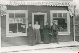
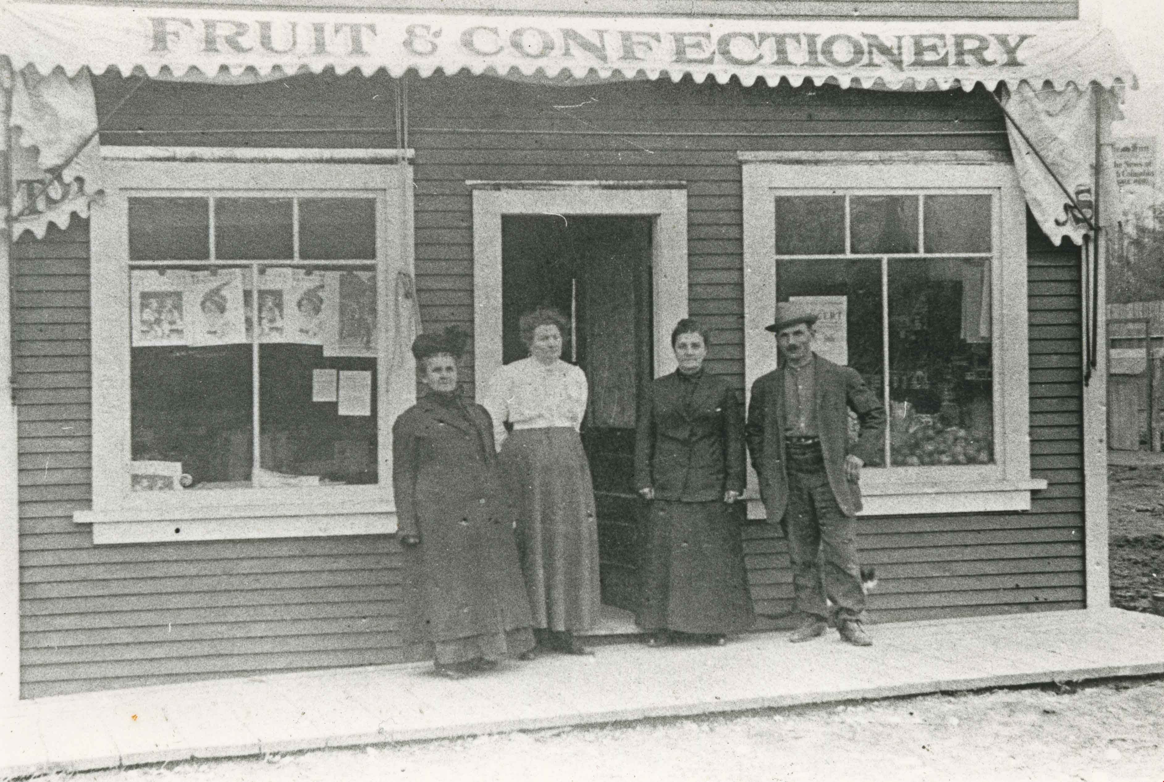
- Photograph of Joseph "Joe" Davis and three women standing outside his Fruit and Confectionary store on Royal Oak Avenue located adjacent to the Royal Oak station on the Central Park Interurban tram line.
- Repository
- City of Burnaby Archives
- Date
- 1912 (date of original), copied 1986
- Collection/Fonds
- Burnaby Historical Society fonds
- Subseries
- Pioneer Tales subseries
- Physical Description
- 1 photograph : b&w ; 12.7 x 17.8 cm print
- Description Level
- Item
- Record No.
- 204-091
- Access Restriction
- No restrictions
- Reproduction Restriction
- No known restrictions
- Accession Number
- BHS1988-03
- Scope and Content
- Photograph of Joseph "Joe" Davis and three women standing outside his Fruit and Confectionary store on Royal Oak Avenue located adjacent to the Royal Oak station on the Central Park Interurban tram line.
- Subjects
- Buildings - Commercial - Stores
- Names
- Davis, Joseph "Joe"
- Media Type
- Photograph
- Notes
- Title based on contents of photograph
- Geographic Access
- Royal Oak Avenue
- Street Address
- 6929 Royal Oak Avenue
- Historic Neighbourhood
- Central Park (Historic Neighbourhood)
- Planning Study Area
- Marlborough Area
Images
John Engelland
https://search.heritageburnaby.ca/link/archivedescription35754
- Repository
- City of Burnaby Archives
- Date
- 1914 (date of original), copied 1986
- Collection/Fonds
- Burnaby Historical Society fonds
- Description Level
- Item
- Physical Description
- 1 photograph : b&w ; 12.7 x 17.8 cm print
- Scope and Content
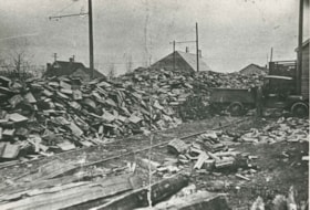
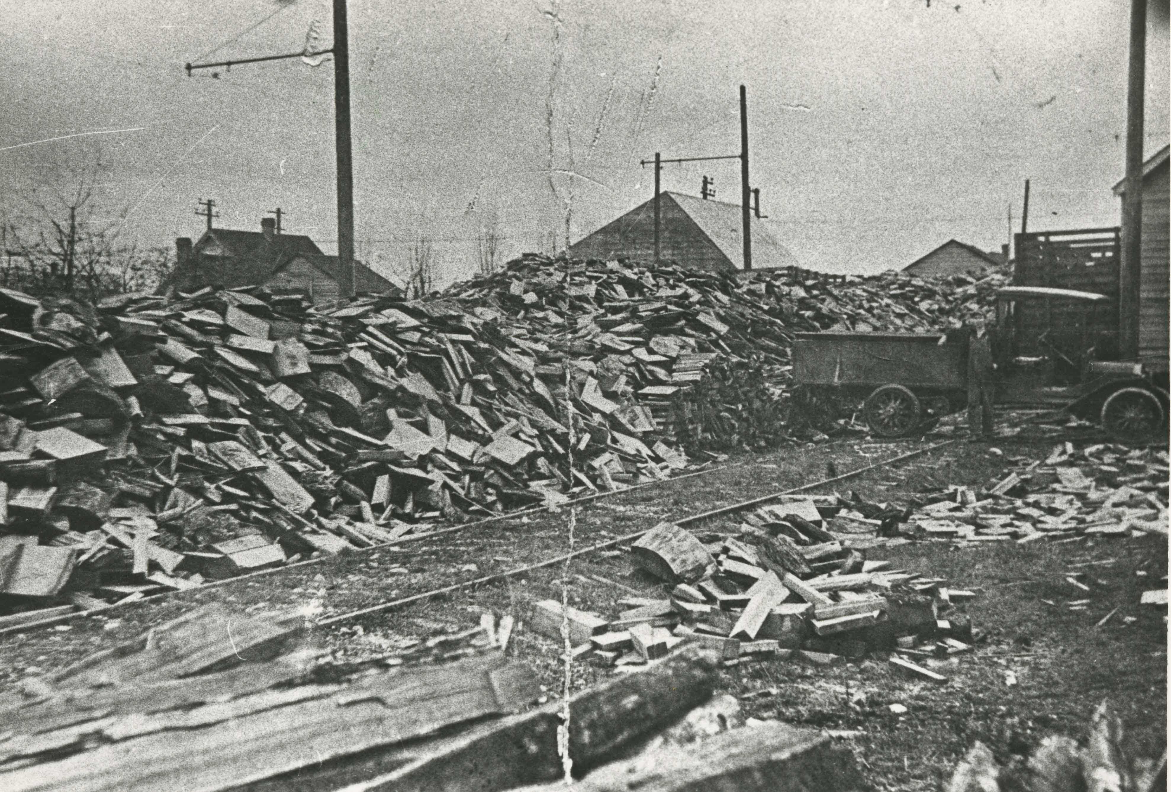
- Photograph of John Engelland hauling firewood at his business at 2643 Fern Avenue (later renumbered 6590 Fern Avenue). Note the railway spur line from the Central Park Interurban.
- Repository
- City of Burnaby Archives
- Date
- 1914 (date of original), copied 1986
- Collection/Fonds
- Burnaby Historical Society fonds
- Subseries
- Pioneer Tales subseries
- Physical Description
- 1 photograph : b&w ; 12.7 x 17.8 cm print
- Description Level
- Item
- Record No.
- 204-612
- Access Restriction
- No restrictions
- Reproduction Restriction
- No known restrictions
- Accession Number
- BHS1988-03
- Scope and Content
- Photograph of John Engelland hauling firewood at his business at 2643 Fern Avenue (later renumbered 6590 Fern Avenue). Note the railway spur line from the Central Park Interurban.
- Media Type
- Photograph
- Notes
- Title based on contents of photograph
- Geographic Access
- Fern Avenue
- Street Address
- 6590 Fern Avenue
- Historic Neighbourhood
- Central Park (Historic Neighbourhood)
- Planning Study Area
- Marlborough Area
Images
![Jubilee Drug Store, [1918] thumbnail](/media/hpo/_Data/_Archives_Images/_Unrestricted/126/187-001.jpg?width=280)
Jubilee Drug Store
https://search.heritageburnaby.ca/link/archivedescription35068
- Repository
- City of Burnaby Archives
- Date
- [1918]
- Collection/Fonds
- Burnaby Historical Society fonds
- Description Level
- Item
- Physical Description
- 1 photograph : b&w ; 8.8 x 12.6 cm print
- Scope and Content
- Photograph of the exterior of Jubilee Drug Store, Jubilee Avenue and Imperial Street (later the location of Bonsor Park, 6550 Bonsor Avenue). Signs on the front of the store read, "Jubilee Drug Store / Drugs / Prescriptions / Lending Library / The Rexall Store." Signs on the side of the building …
- Repository
- City of Burnaby Archives
- Date
- [1918]
- Collection/Fonds
- Burnaby Historical Society fonds
- Subseries
- Heyworth family subseries
- Physical Description
- 1 photograph : b&w ; 8.8 x 12.6 cm print
- Description Level
- Item
- Record No.
- 187-001
- Access Restriction
- No restrictions
- Reproduction Restriction
- No known restrictions
- Accession Number
- BHS1986-38
- Scope and Content
- Photograph of the exterior of Jubilee Drug Store, Jubilee Avenue and Imperial Street (later the location of Bonsor Park, 6550 Bonsor Avenue). Signs on the front of the store read, "Jubilee Drug Store / Drugs / Prescriptions / Lending Library / The Rexall Store." Signs on the side of the building read, "Jubilee Drug Store / Films / Magazines / Violin Strings / Sargon / Puretest Drugs / Rexall Drug Store / NYAL Service Drugstore / Lending Library." A man is standing outside the store (this may be Mr. G.R. Heyworth).
- Names
- Jubilee Drug Store
- Media Type
- Photograph
- Notes
- Title based on contents of photograph
- Geographic Access
- Jubilee Avenue
- Bonsor Avenue
- Street Address
- 6550 Bonsor Avenue
- Historic Neighbourhood
- Central Park (Historic Neighbourhood)
- Planning Study Area
- Marlborough Area
Images
![Jubilee Drug Store, [1918] thumbnail](/media/hpo/_Data/_Archives_Images/_Unrestricted/126/187-001.jpg)