Narrow Results By
Creator
- Bellinger, Bernard 1
- Bridgman's Studio Limited 2
- British Columbia Underwriters' Association 7
- Bryce, Henry G. 1
- Bryce, H.G. 1
- Eaton, Dr. Carl 2
- Frank, Leonard 1
- Lloyd, Frank Ernest 7
- Lloyd's Studio 11
- Plan Department, British Columbia Insurance Underwriters' Association 6
- Stride, Charles Edgar 14
- Thomson, Stuart 1
Canadian Confederation Celebration Committee
https://search.heritageburnaby.ca/link/archivedescription36609
- Repository
- City of Burnaby Archives
- Date
- 1927
- Collection/Fonds
- Burnaby Historical Society fonds
- Description Level
- Item
- Physical Description
- 1 photograph : sepia ; 14 x 24 cm (sight) in mat 25 x 35.5 cm
- Scope and Content
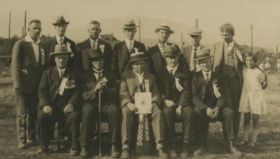
- Photograph of the Canada Confederation Celebration Committee sitting and standing in two rows on the Central Park Sports field.
- Repository
- City of Burnaby Archives
- Date
- 1927
- Collection/Fonds
- Burnaby Historical Society fonds
- Subseries
- J.P. Dickson subseries
- Physical Description
- 1 photograph : sepia ; 14 x 24 cm (sight) in mat 25 x 35.5 cm
- Description Level
- Item
- Record No.
- 308-002
- Access Restriction
- No restrictions
- Reproduction Restriction
- No restrictions
- Accession Number
- BHS1992-51
- Scope and Content
- Photograph of the Canada Confederation Celebration Committee sitting and standing in two rows on the Central Park Sports field.
- Subjects
- Organizations
- Media Type
- Photograph
- Photographer
- Lloyd's Studio
- Notes
- Title based on contents of photograph
- Photographer's stamp on verso of mat reads: "Lloyd's Studio/ 3966 Kingsway/ McKay BC Carl. 343R2"
- Geographic Access
- Central Park
- Imperial Street
- Street Address
- 3883 Imperial Street
- Historic Neighbourhood
- Central Park (Historic Neighbourhood)
- Planning Study Area
- Maywood Area
Images

![Car bumpers, [between 1920 and 1938] thumbnail](/media/hpo/_Data/_BVM_Images/1990/199200450041.jpg?width=280)
Car bumpers
https://search.heritageburnaby.ca/link/museumdescription1150
- Repository
- Burnaby Village Museum
- Date
- [between 1920 and 1938]
- Collection/Fonds
- Burnaby Village Museum Photograph collection
- Description Level
- Item
- Physical Description
- 1 photograph : sepia ; 10.5 x 6 cm
- Scope and Content
- Photograph of two examples of Wagner car bumpers propped up on display outside Frank Wagner's blacksmithing shop (along the 4000 block of Kingsway across from the gate to Central Park).
- Repository
- Burnaby Village Museum
- Collection/Fonds
- Burnaby Village Museum Photograph collection
- Description Level
- Item
- Physical Description
- 1 photograph : sepia ; 10.5 x 6 cm
- Scope and Content
- Photograph of two examples of Wagner car bumpers propped up on display outside Frank Wagner's blacksmithing shop (along the 4000 block of Kingsway across from the gate to Central Park).
- Names
- Wagner, Frank
- Geographic Access
- Kingsway
- Accession Code
- BV992.45.41
- Access Restriction
- No restrictions
- Reproduction Restriction
- No known restrictions
- Date
- [between 1920 and 1938]
- Media Type
- Photograph
- Historic Neighbourhood
- Central Park (Historic Neighbourhood)
- Planning Study Area
- Maywood Area
- Scan Resolution
- 600
- Scan Date
- 01-Jun-09
- Scale
- 100
- Notes
- Title based on contents of photograph
Images
![Car bumpers, [between 1920 and 1938] thumbnail](/media/hpo/_Data/_BVM_Images/1990/199200450041.jpg)
![Car bumpers, [between 1920 and 1938] thumbnail](/media/hpo/_Data/_BVM_Images/1990/199200450052.jpg?width=280)
Car bumpers
https://search.heritageburnaby.ca/link/museumdescription1159
- Repository
- Burnaby Village Museum
- Date
- [between 1920 and 1938]
- Collection/Fonds
- Burnaby Village Museum Photograph collection
- Description Level
- Item
- Physical Description
- 1 photograph : sepia ; 10.5 x 6 cm
- Scope and Content
- Photograph of examples of Wagner Triple Spring car bumpers propped up on display outside Frank Wagner's blacksmithing shop (along the 4000 block of Kingsway across from the gate to Central Park).
- Repository
- Burnaby Village Museum
- Collection/Fonds
- Burnaby Village Museum Photograph collection
- Description Level
- Item
- Physical Description
- 1 photograph : sepia ; 10.5 x 6 cm
- Scope and Content
- Photograph of examples of Wagner Triple Spring car bumpers propped up on display outside Frank Wagner's blacksmithing shop (along the 4000 block of Kingsway across from the gate to Central Park).
- Names
- Wagner, Frank
- Geographic Access
- Kingsway
- Accession Code
- BV992.45.52
- Access Restriction
- No restrictions
- Reproduction Restriction
- No known restrictions
- Date
- [between 1920 and 1938]
- Media Type
- Photograph
- Historic Neighbourhood
- Central Park (Historic Neighbourhood)
- Planning Study Area
- Maywood Area
- Scan Resolution
- 600
- Scan Date
- 01-Jun-09
- Scale
- 100
- Notes
- Title based on contents of photograph
Images
![Car bumpers, [between 1920 and 1938] thumbnail](/media/hpo/_Data/_BVM_Images/1990/199200450052.jpg)
![Carpenter family garden, [192-] (date of original), copied 1986 thumbnail](/media/hpo/_Data/_Archives_Images/_Unrestricted/204/204-648.jpg?width=280)
Carpenter family garden
https://search.heritageburnaby.ca/link/archivedescription35790
- Repository
- City of Burnaby Archives
- Date
- [192-] (date of original), copied 1986
- Collection/Fonds
- Burnaby Historical Society fonds
- Description Level
- Item
- Physical Description
- 1 photograph : b&w ; 12.7 x 17.8 cm print
- Scope and Content
- Photograph of the onion patch at the Carpenter family home at 3336 Beresford Street (later renumbered 5268 Beresford Street) near Royal Oak Avenue. Mr. Carpenter raised other vegetables and won many prizes at the Pacific National Exhibition (PNE).
- Repository
- City of Burnaby Archives
- Date
- [192-] (date of original), copied 1986
- Collection/Fonds
- Burnaby Historical Society fonds
- Subseries
- Pioneer Tales subseries
- Physical Description
- 1 photograph : b&w ; 12.7 x 17.8 cm print
- Description Level
- Item
- Record No.
- 204-648
- Access Restriction
- No restrictions
- Reproduction Restriction
- No known restrictions
- Accession Number
- BHS1988-03
- Scope and Content
- Photograph of the onion patch at the Carpenter family home at 3336 Beresford Street (later renumbered 5268 Beresford Street) near Royal Oak Avenue. Mr. Carpenter raised other vegetables and won many prizes at the Pacific National Exhibition (PNE).
- Subjects
- Geographic Features - Gardens
- Media Type
- Photograph
- Notes
- Title based on contents of photograph
- Geographic Access
- Beresford Street
- Street Address
- 5268 Beresford Street
- Historic Neighbourhood
- Central Park (Historic Neighbourhood)
- Planning Study Area
- Windsor Area
Images
![Carpenter family garden, [192-] (date of original), copied 1986 thumbnail](/media/hpo/_Data/_Archives_Images/_Unrestricted/204/204-648.jpg)
![Carpenter's English Garden, [192-] (date of original), copied 1986 thumbnail](/media/hpo/_Data/_Archives_Images/_Unrestricted/204/204-646.jpg?width=280)
Carpenter's English Garden
https://search.heritageburnaby.ca/link/archivedescription35788
- Repository
- City of Burnaby Archives
- Date
- [192-] (date of original), copied 1986
- Collection/Fonds
- Burnaby Historical Society fonds
- Description Level
- Item
- Physical Description
- 1 photograph : b&w ; 12.7 x 17.8 cm print
- Scope and Content
- Photograph of Ernie Carpenter's English garden at 3336 Beresford Street (later renumbered 5268 Beresford Street) near Royal Oak Avenue. He later built a second garden after the family moved into a house on Neville Street, South Burnaby.
- Repository
- City of Burnaby Archives
- Date
- [192-] (date of original), copied 1986
- Collection/Fonds
- Burnaby Historical Society fonds
- Subseries
- Pioneer Tales subseries
- Physical Description
- 1 photograph : b&w ; 12.7 x 17.8 cm print
- Description Level
- Item
- Record No.
- 204-646
- Access Restriction
- No restrictions
- Reproduction Restriction
- No known restrictions
- Accession Number
- BHS1988-03
- Scope and Content
- Photograph of Ernie Carpenter's English garden at 3336 Beresford Street (later renumbered 5268 Beresford Street) near Royal Oak Avenue. He later built a second garden after the family moved into a house on Neville Street, South Burnaby.
- Subjects
- Geographic Features - Gardens
- Media Type
- Photograph
- Notes
- Title based on contents of photograph
- Geographic Access
- Beresford Street
- Street Address
- 5268 Beresford Street
- Historic Neighbourhood
- Central Park (Historic Neighbourhood)
- Planning Study Area
- Windsor Area
Images
![Carpenter's English Garden, [192-] (date of original), copied 1986 thumbnail](/media/hpo/_Data/_Archives_Images/_Unrestricted/204/204-646.jpg)
![Central Park, [1921] thumbnail](/media/hpo/_Data/_Archives_Images/_Unrestricted/513/521-018.jpg?width=280)
Central Park
https://search.heritageburnaby.ca/link/archivedescription65785
- Repository
- City of Burnaby Archives
- Date
- [1921]
- Collection/Fonds
- Field family fonds
- Description Level
- Item
- Physical Description
- 1 photograph (tiff) ; 600 ppi
- Scope and Content
- Photograph of Willie James Field, his wife Laura Tonkin (Field) and brother to Laura, Charles Henry (Harry) Tonkin in their car at the entrance to Central Park. The Central Park arch is prominent in the photograph. In 1921 the family drove in this car from Moose Jaw, Saskatchewan to Burnaby and in …
- Repository
- City of Burnaby Archives
- Date
- [1921]
- Collection/Fonds
- Field family fonds
- Physical Description
- 1 photograph (tiff) ; 600 ppi
- Material Details
- Item is a scan of a sepia photograph that is permanently adhered to black paper at verso
- Description Level
- Item
- Record No.
- 521-018
- Access Restriction
- No restrictions
- Reproduction Restriction
- No known restrictions
- Accession Number
- 2010-14
- Scope and Content
- Photograph of Willie James Field, his wife Laura Tonkin (Field) and brother to Laura, Charles Henry (Harry) Tonkin in their car at the entrance to Central Park. The Central Park arch is prominent in the photograph. In 1921 the family drove in this car from Moose Jaw, Saskatchewan to Burnaby and in 1925 they lived across the street from the park on Patterson Avenue.
- Subjects
- Structures - Arches
- Media Type
- Photograph
- Notes
- Title based on contents of photograph
- Geographic Access
- Central Park
- Imperial Street
- Street Address
- 3883 Imperial Street
- Historic Neighbourhood
- Central Park (Historic Neighbourhood)
- Planning Study Area
- Maywood Area
Images
![Central Park, [1921] thumbnail](/media/hpo/_Data/_Archives_Images/_Unrestricted/513/521-018.jpg)
![Central Park, [1921] thumbnail](/media/hpo/_Data/_Archives_Images/_Unrestricted/513/521-031.jpg?width=280)
Central Park
https://search.heritageburnaby.ca/link/archivedescription65799
- Repository
- City of Burnaby Archives
- Date
- [1921]
- Collection/Fonds
- Field family fonds
- Description Level
- Item
- Physical Description
- 1 photograph (tiff) ; 600 ppi
- Scope and Content
- Photograph of for Model-T Fords driving along Kingsway at Central Park. St. John Divine Church is visible on the right.
- Repository
- City of Burnaby Archives
- Date
- [1921]
- Collection/Fonds
- Field family fonds
- Physical Description
- 1 photograph (tiff) ; 600 ppi
- Material Details
- Item is a scan of a sepia photograph that is housed in a photographic album
- Description Level
- Item
- Record No.
- 521-031
- Access Restriction
- No restrictions
- Reproduction Restriction
- No known restrictions
- Accession Number
- 2010-14
- Scope and Content
- Photograph of for Model-T Fords driving along Kingsway at Central Park. St. John Divine Church is visible on the right.
- Subjects
- Transportation - Automobiles
- Media Type
- Photograph
- Notes
- Continuation of title: "Vancouver BC"
- Geographic Access
- Central Park
- Kingsway
- Street Address
- 3891 Kingsway
- Historic Neighbourhood
- Central Park (Historic Neighbourhood)
- Planning Study Area
- Garden Village Area
Images
![Central Park, [1921] thumbnail](/media/hpo/_Data/_Archives_Images/_Unrestricted/513/521-031.jpg)

Central Park
https://search.heritageburnaby.ca/link/archivedescription34862
- Repository
- City of Burnaby Archives
- Date
- 1920 (date of original), photographed 1985
- Collection/Fonds
- Burnaby Historical Society fonds
- Description Level
- Item
- Physical Description
- 1 photograph : b&w ; 8.8 x 11.3 cm
- Scope and Content
- Photograph of the Central Park entrance arch with the "Central Park" electric sign. An Interurban tram can be seen on the right. This photograph used to be hung at the Central Park branch of the Burnaby Public Library.
- Repository
- City of Burnaby Archives
- Date
- 1920 (date of original), photographed 1985
- Collection/Fonds
- Burnaby Historical Society fonds
- Subseries
- Evelyn Salisbury subseries
- Physical Description
- 1 photograph : b&w ; 8.8 x 11.3 cm
- Description Level
- Item
- Record No.
- 145-010
- Access Restriction
- No restrictions
- Reproduction Restriction
- No known restrictions
- Accession Number
- BHS1985-15
- Scope and Content
- Photograph of the Central Park entrance arch with the "Central Park" electric sign. An Interurban tram can be seen on the right. This photograph used to be hung at the Central Park branch of the Burnaby Public Library.
- Subjects
- Structures - Arches
- Advertising Medium - Signs and Signboards
- Geographic Features - Parks
- Transportation - Electric Railroads
- Media Type
- Photograph
- Notes
- Title based on contents of photograph
- Geographic Access
- Central Park
- Imperial Street
- Street Address
- 3883 Imperial Street
- Historic Neighbourhood
- Central Park (Historic Neighbourhood)
- Planning Study Area
- Maywood Area
Images

Central Park Agricultural Hall
https://search.heritageburnaby.ca/link/archivedescription36671
- Repository
- City of Burnaby Archives
- Date
- 1920 (date of original), copied 1992
- Collection/Fonds
- Burnaby Historical Society fonds
- Description Level
- Item
- Physical Description
- 1 photograph : b&w ; 10.1 x 14.9 cm print
- Scope and Content
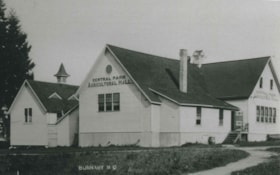
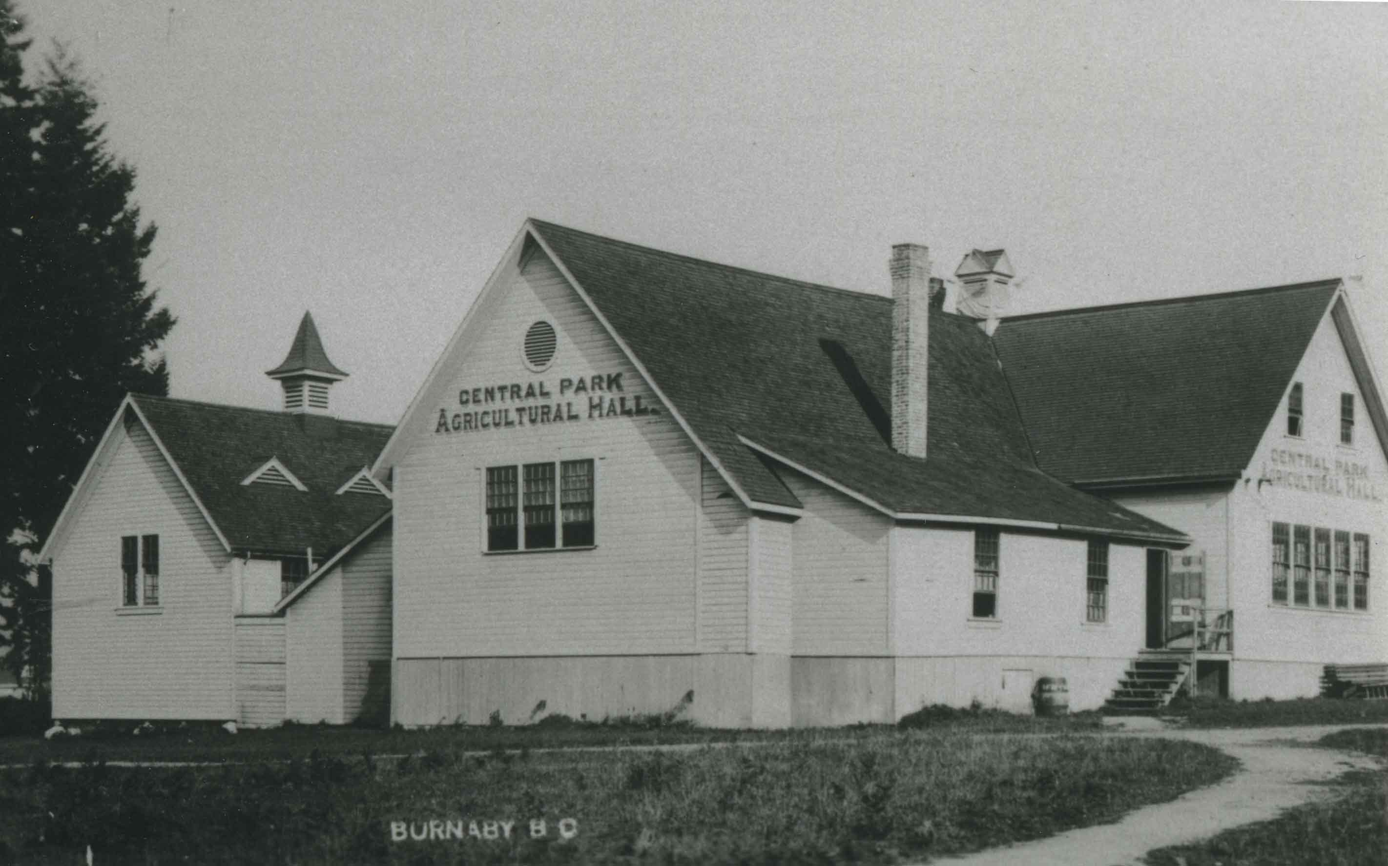
- Photograph of the Central Park Agricultural Hall which was built on the triangular part of the park at Kingsway near Patterson.
- Repository
- City of Burnaby Archives
- Date
- 1920 (date of original), copied 1992
- Collection/Fonds
- Burnaby Historical Society fonds
- Subseries
- Burnaby Centennial Anthology subseries
- Physical Description
- 1 photograph : b&w ; 10.1 x 14.9 cm print
- Description Level
- Item
- Record No.
- 315-026
- Access Restriction
- No restrictions
- Reproduction Restriction
- No known restrictions
- Accession Number
- BHS1994-04
- Scope and Content
- Photograph of the Central Park Agricultural Hall which was built on the triangular part of the park at Kingsway near Patterson.
- Subjects
- Buildings - Agricultural
- Media Type
- Photograph
- Notes
- Title based on contents of photograph
- Copy taken from original b&w photographic postcard
- Geographic Access
- Central Park
- Imperial Street
- Street Address
- 3883 Imperial Street
- Historic Neighbourhood
- Central Park (Historic Neighbourhood)
- Planning Study Area
- Maywood Area
Images
![Central Park Auto Tourist Grounds, Vancouver Canada, [1923] thumbnail](/media/hpo/_Data/_Archives_Images/_Unrestricted/371/449-007.jpg?width=280)
Central Park Auto Tourist Grounds, Vancouver Canada
https://search.heritageburnaby.ca/link/archivedescription38512
- Repository
- City of Burnaby Archives
- Date
- [1923]
- Collection/Fonds
- Burnaby Historical Society fonds
- Description Level
- Item
- Physical Description
- 1 photograph : sepia postcard ; 9 x 14 cm
- Scope and Content
- Photographic postcard of the Central Park auto tourist grounds. Two unidentified men can be seen standing in front of a car which is parked next to the campground building. In the background, a clothesline has been strung holding towels and blankets.
- Repository
- City of Burnaby Archives
- Date
- [1923]
- Collection/Fonds
- Burnaby Historical Society fonds
- Subseries
- Photographs subseries
- Physical Description
- 1 photograph : sepia postcard ; 9 x 14 cm
- Description Level
- Item
- Record No.
- 449-007
- Access Restriction
- No restrictions
- Reproduction Restriction
- No known restrictions
- Accession Number
- BHS2007-04
- Scope and Content
- Photographic postcard of the Central Park auto tourist grounds. Two unidentified men can be seen standing in front of a car which is parked next to the campground building. In the background, a clothesline has been strung holding towels and blankets.
- Subjects
- Buildings - Commercial - Hotels and Motels
- Geographic Features - Parks
- Documentary Artifacts - Postcards
- Recreational Activities - Camping
- Media Type
- Photograph
- Notes
- Title based on caption
- Geographic Access
- Central Park
- Imperial Street
- Street Address
- 3883 Imperial Street
- Historic Neighbourhood
- Central Park (Historic Neighbourhood)
- Planning Study Area
- Maywood Area
Images
![Central Park Auto Tourist Grounds, Vancouver Canada, [1923] thumbnail](/media/hpo/_Data/_Archives_Images/_Unrestricted/371/449-007.jpg)

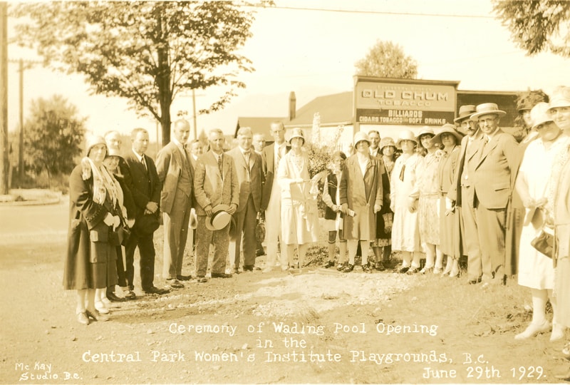
Ceremony of Wading Pool Opening
https://search.heritageburnaby.ca/link/museumdescription1113
- Repository
- Burnaby Village Museum
- Date
- June 29, 1929
- Collection/Fonds
- Burnaby Village Museum Photograph collection
- Description Level
- Item
- Physical Description
- 1 photograph : sepia ; 11 x 17 cm
- Scope and Content
- Photograph taken at the ceremony of a wading pool opening in the Central Park Women's Insitute Playgrounds. Men, women and a boy are gathered outside in front of a building. A signboard reads, "Everybody Smokes / Old Chum / Tobacco / Billiards / Cigar Tobacco and Soft Drinks."
- Repository
- Burnaby Village Museum
- Collection/Fonds
- Burnaby Village Museum Photograph collection
- Description Level
- Item
- Physical Description
- 1 photograph : sepia ; 11 x 17 cm
- Scope and Content
- Photograph taken at the ceremony of a wading pool opening in the Central Park Women's Insitute Playgrounds. Men, women and a boy are gathered outside in front of a building. A signboard reads, "Everybody Smokes / Old Chum / Tobacco / Billiards / Cigar Tobacco and Soft Drinks."
- Subjects
- Events - Openings
- Organizations
- Geographic Access
- Imperial Street
- Central Park
- Street Address
- 3883 Imperial Street
- Accession Code
- HV972.204.1
- Access Restriction
- No restrictions
- Reproduction Restriction
- May be restricted by third party rights
- Date
- June 29, 1929
- Media Type
- Photograph
- Historic Neighbourhood
- Central Park (Historic Neighbourhood)
- Planning Study Area
- Maywood Area
- Scan Resolution
- 600
- Scan Date
- 2023-04-25
- Photographer
- Lloyd, Frank Ernest
- Notes
- Title based on caption of photograph
- An accompanying catalogue note reads: "'Burnaby Broadcast' Thursday, June 6, 1929. p3 / Central Park Women's Institute asked permission to make collections in West Burnaby and Inman Avenue schools to raise money to construct a wading pool in Central Park. They will be informed that the Board appreciate their enterprise on behalf of the children but regret it is against the policy of the Board to allow such collections."
- Inscribed on the negative and printed on the bottom of the photograph: "Ceremony of Wading Pool Opening in the Central Park Women's Institute Playgrounds, B.C. / McKay Studio. B.C. / June 29th 1929." Stamped on the back of the photograph: "Lloyd's Studio / 3966 Kingsway / / McKay, B.C. Carl. 1012."
Images
![Chamberlain Chicken Coop, [ca. 1920] (date of original), copied 1986 thumbnail](/media/hpo/_Data/_Archives_Images/_Unrestricted/126/179-006.jpg?width=280)
Chamberlain Chicken Coop
https://search.heritageburnaby.ca/link/archivedescription35035
- Repository
- City of Burnaby Archives
- Date
- [ca. 1920] (date of original), copied 1986
- Collection/Fonds
- Burnaby Historical Society fonds
- Description Level
- Item
- Physical Description
- 1 photograph : b&w ; 8.8 x 12.6 cm print
- Scope and Content
- Photograph of the exterior of the Chamberlain family chicken coop. The coop was originally a house. A man and three cows are seen outside it. This may be 6389 Elgin Avenue.
- Repository
- City of Burnaby Archives
- Date
- [ca. 1920] (date of original), copied 1986
- Collection/Fonds
- Burnaby Historical Society fonds
- Subseries
- Chamberlain family subseries
- Physical Description
- 1 photograph : b&w ; 8.8 x 12.6 cm print
- Description Level
- Item
- Record No.
- 179-006
- Access Restriction
- No restrictions
- Reproduction Restriction
- No known restrictions
- Accession Number
- BHS1986-27
- Scope and Content
- Photograph of the exterior of the Chamberlain family chicken coop. The coop was originally a house. A man and three cows are seen outside it. This may be 6389 Elgin Avenue.
- Subjects
- Animals - Cows
- Buildings - Agricultural
- Media Type
- Photograph
- Notes
- Title based on contents of photograph
- Street Address
- 6389 Elgin Avenue
- Historic Neighbourhood
- Central Park (Historic Neighbourhood)
- Planning Study Area
- Windsor Area
Images
![Chamberlain Chicken Coop, [ca. 1920] (date of original), copied 1986 thumbnail](/media/hpo/_Data/_Archives_Images/_Unrestricted/126/179-006.jpg)
![Charles R. Gillmore, [192-] (date of original), copied 1986 thumbnail](/media/hpo/_Data/_Archives_Images/_Unrestricted/204/204-252.jpg?width=280)
Charles R. Gillmore
https://search.heritageburnaby.ca/link/archivedescription35395
- Repository
- City of Burnaby Archives
- Date
- [192-] (date of original), copied 1986
- Collection/Fonds
- Burnaby Historical Society fonds
- Description Level
- Item
- Physical Description
- 1 photograph : b&w ; 12.7 x 17.8 cm print
- Scope and Content
- Photograph of Charles R. Gillmore, operator of Fernhurst Game Farm near Imperial Street and Dow Avenue. This later became the site of Maywood Elementary School at 4567 Imperial Street.
- Repository
- City of Burnaby Archives
- Date
- [192-] (date of original), copied 1986
- Collection/Fonds
- Burnaby Historical Society fonds
- Subseries
- Pioneer Tales subseries
- Physical Description
- 1 photograph : b&w ; 12.7 x 17.8 cm print
- Description Level
- Item
- Record No.
- 204-252
- Access Restriction
- No restrictions
- Reproduction Restriction
- No known restrictions
- Accession Number
- BHS1988-03
- Scope and Content
- Photograph of Charles R. Gillmore, operator of Fernhurst Game Farm near Imperial Street and Dow Avenue. This later became the site of Maywood Elementary School at 4567 Imperial Street.
- Media Type
- Photograph
- Notes
- Title based on contents of photograph
- Geographic Access
- Imperial Street
- Street Address
- 4567 Imperial Street
- Historic Neighbourhood
- Central Park (Historic Neighbourhood)
- Planning Study Area
- Maywood Area
Images
![Charles R. Gillmore, [192-] (date of original), copied 1986 thumbnail](/media/hpo/_Data/_Archives_Images/_Unrestricted/204/204-252.jpg)
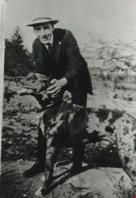
Charles R. Gillmore and Nell
https://search.heritageburnaby.ca/link/archivedescription35397
- Repository
- City of Burnaby Archives
- Date
- 1920
- Collection/Fonds
- Burnaby Historical Society fonds
- Description Level
- Item
- Physical Description
- 1 photograph : b&w ; 12.7 x 17.8 cm print
- Scope and Content
- Photograph of Charles R. Gillmore and Nell, the Charles R. Gillmore family's first Great Dane. This later became the site of Maywood Elementary School at 4567 Imperial Street.
- Repository
- City of Burnaby Archives
- Date
- 1920
- Collection/Fonds
- Burnaby Historical Society fonds
- Subseries
- Pioneer Tales subseries
- Physical Description
- 1 photograph : b&w ; 12.7 x 17.8 cm print
- Description Level
- Item
- Record No.
- 204-254
- Access Restriction
- No restrictions
- Reproduction Restriction
- No known restrictions
- Accession Number
- BHS1988-03
- Scope and Content
- Photograph of Charles R. Gillmore and Nell, the Charles R. Gillmore family's first Great Dane. This later became the site of Maywood Elementary School at 4567 Imperial Street.
- Subjects
- Animals - Dogs
- Names
- Gillmore, Charles R.
- Media Type
- Photograph
- Notes
- Title based on contents of photograph
- Geographic Access
- Imperial Street
- Street Address
- 4567 Imperial Street
- Historic Neighbourhood
- Central Park (Historic Neighbourhood)
- Planning Study Area
- Maywood Area
Images
![Children at Forster house, [1925] (date of original), copied 1986 thumbnail](/media/hpo/_Data/_Archives_Images/_Unrestricted/126/168-009.jpg?width=280)
Children at Forster house
https://search.heritageburnaby.ca/link/archivedescription34974
- Repository
- City of Burnaby Archives
- Date
- [1925] (date of original), copied 1986
- Collection/Fonds
- Burnaby Historical Society fonds
- Description Level
- Item
- Physical Description
- 1 photograph : b&w ; 8.8 x 12.5 cm print
- Scope and Content
- Photograph of a group of children seated on the steps of the Forster family's second house on McKay Avenue.
- Repository
- City of Burnaby Archives
- Date
- [1925] (date of original), copied 1986
- Collection/Fonds
- Burnaby Historical Society fonds
- Subseries
- Forster family subseries
- Physical Description
- 1 photograph : b&w ; 8.8 x 12.5 cm print
- Description Level
- Item
- Record No.
- 168-009
- Access Restriction
- No restrictions
- Reproduction Restriction
- No known restrictions
- Accession Number
- BHS1986-17
- Scope and Content
- Photograph of a group of children seated on the steps of the Forster family's second house on McKay Avenue.
- Media Type
- Photograph
- Notes
- Title based on contents of photograph
- Geographic Access
- McKay Avenue
- Historic Neighbourhood
- Central Park (Historic Neighbourhood)
- Planning Study Area
- Maywood Area
Images
![Children at Forster house, [1925] (date of original), copied 1986 thumbnail](/media/hpo/_Data/_Archives_Images/_Unrestricted/126/168-009.jpg)
![Child's homemade driveable toy car, [1923] thumbnail](/media/hpo/_Data/_Archives_Images/_Unrestricted/370/370-337.jpg?width=280)
Child's homemade driveable toy car
https://search.heritageburnaby.ca/link/archivedescription37749
- Repository
- City of Burnaby Archives
- Date
- [1923]
- Collection/Fonds
- Burnaby Historical Society fonds
- Description Level
- Item
- Physical Description
- 1 photograph : b&w ; 2.6 x 4.5 cm prints on contact sheet 20.3 x 26.6 cm
- Scope and Content
- Photograph of a child's homemade driveable toy car, in the backyard of 2313 Nelson Avenue (later renumbered 6926 Nelson Avenue).
- Repository
- City of Burnaby Archives
- Date
- [1923]
- Collection/Fonds
- Burnaby Historical Society fonds
- Subseries
- Burnaby Image Bank subseries
- Physical Description
- 1 photograph : b&w ; 2.6 x 4.5 cm prints on contact sheet 20.3 x 26.6 cm
- Description Level
- Item
- Record No.
- 370-337
- Access Restriction
- No restrictions
- Reproduction Restriction
- No known restrictions
- Accession Number
- BHS1999-03
- Scope and Content
- Photograph of a child's homemade driveable toy car, in the backyard of 2313 Nelson Avenue (later renumbered 6926 Nelson Avenue).
- Subjects
- Toys
- Transportation - Automobiles
- Media Type
- Photograph
- Notes
- Title based on contents of photograph
- 1 b&w copy negative accompanying
- Negative has a pink cast
- Geographic Access
- Nelson Avenue
- Street Address
- 6926 Nelson Avenue
- Historic Neighbourhood
- Central Park (Historic Neighbourhood)
- Planning Study Area
- Sussex-Nelson Area
Images
![Child's homemade driveable toy car, [1923] thumbnail](/media/hpo/_Data/_Archives_Images/_Unrestricted/370/370-337.jpg)
![Clifford Pitman, [192-] (date of original), copied 1986 thumbnail](/media/hpo/_Data/_Archives_Images/_Unrestricted/204/204-623.jpg?width=280)
Clifford Pitman
https://search.heritageburnaby.ca/link/archivedescription35765
- Repository
- City of Burnaby Archives
- Date
- [192-] (date of original), copied 1986
- Collection/Fonds
- Burnaby Historical Society fonds
- Description Level
- Item
- Physical Description
- 1 photograph : b&w ; 12.7 x 17.8 cm print
- Scope and Content
- Photograph of Clifford Pitman (brother of Gwendolyn Pitman) outside their family home at 2766 Cassie Avenue (later renumbered 6291 Cassie Avenue), South Burnaby, near the McKay Interurban station.
- Repository
- City of Burnaby Archives
- Date
- [192-] (date of original), copied 1986
- Collection/Fonds
- Burnaby Historical Society fonds
- Subseries
- Pioneer Tales subseries
- Physical Description
- 1 photograph : b&w ; 12.7 x 17.8 cm print
- Description Level
- Item
- Record No.
- 204-623
- Access Restriction
- No restrictions
- Reproduction Restriction
- No known restrictions
- Accession Number
- BHS1988-03
- Scope and Content
- Photograph of Clifford Pitman (brother of Gwendolyn Pitman) outside their family home at 2766 Cassie Avenue (later renumbered 6291 Cassie Avenue), South Burnaby, near the McKay Interurban station.
- Names
- Pitman, Clifford
- Media Type
- Photograph
- Notes
- Title based on contents of photograph
- Geographic Access
- Cassie Avenue
- Street Address
- 6291 Cassie Avenue
- Historic Neighbourhood
- Central Park (Historic Neighbourhood)
- Planning Study Area
- Maywood Area
Images
![Clifford Pitman, [192-] (date of original), copied 1986 thumbnail](/media/hpo/_Data/_Archives_Images/_Unrestricted/204/204-623.jpg)
![Clissie Buxton aged 18 years, [1920] thumbnail](/media/hpo/_Data/_Archives_Images/_Unrestricted/513/513-006.JPG?width=280)
Clissie Buxton aged 18 years
https://search.heritageburnaby.ca/link/archivedescription64634
- Repository
- City of Burnaby Archives
- Date
- [1920]
- Collection/Fonds
- Buxton Family collection
- Description Level
- Item
- Physical Description
- 1 photograph (jpeg) : b&w
- Scope and Content
- Photograph shows Alice Clarissa (Clissie) Buxton at age 18, holding a tennis racket. Clissie was the daughter of George Searby Buxton and Mary Isabel (nee Nattriss). The photograph was likely taken at the Buxton family home in Burnaby.
- Repository
- City of Burnaby Archives
- Date
- [1920]
- Collection/Fonds
- Buxton Family collection
- Physical Description
- 1 photograph (jpeg) : b&w
- Description Level
- Item
- Record No.
- 513-006
- Access Restriction
- No restrictions
- Reproduction Restriction
- No known restrictions
- Accession Number
- 2010-05
- Scope and Content
- Photograph shows Alice Clarissa (Clissie) Buxton at age 18, holding a tennis racket. Clissie was the daughter of George Searby Buxton and Mary Isabel (nee Nattriss). The photograph was likely taken at the Buxton family home in Burnaby.
- Subjects
- Sports - Tennis
- Media Type
- Photograph
- Geographic Access
- Buxton Street
- Street Address
- 4807 Buxton Street
- Historic Neighbourhood
- Central Park (Historic Neighbourhood)
- Planning Study Area
- Marlborough Area
Images
![Clissie Buxton aged 18 years, [1920] thumbnail](/media/hpo/_Data/_Archives_Images/_Unrestricted/513/513-006.JPG)

Cram family fruit stand
https://search.heritageburnaby.ca/link/archivedescription35703
- Repository
- City of Burnaby Archives
- Date
- 1920 (date of original), copied 1986
- Collection/Fonds
- Burnaby Historical Society fonds
- Description Level
- Item
- Physical Description
- 1 photograph : b&w ; 12.7 x 17.8 cm print
- Scope and Content
- Photograph of the Cram roadside fruit stand on Kingsway with Mary Cram in front. The Cram family sold fruit, produce, honey, and cottage cheese from their farm at Kingsway and what is now 6515 Denbigh Avenue. The stand was located directly in front of the Cram-Tidball family home.
- Repository
- City of Burnaby Archives
- Date
- 1920 (date of original), copied 1986
- Collection/Fonds
- Burnaby Historical Society fonds
- Subseries
- Pioneer Tales subseries
- Physical Description
- 1 photograph : b&w ; 12.7 x 17.8 cm print
- Description Level
- Item
- Record No.
- 204-561
- Access Restriction
- No restrictions
- Reproduction Restriction
- No known restrictions
- Accession Number
- BHS1988-03
- Scope and Content
- Photograph of the Cram roadside fruit stand on Kingsway with Mary Cram in front. The Cram family sold fruit, produce, honey, and cottage cheese from their farm at Kingsway and what is now 6515 Denbigh Avenue. The stand was located directly in front of the Cram-Tidball family home.
- Names
- Vogt, Mary Cram
- Media Type
- Photograph
- Notes
- Title based on contents of photograph
- Geographic Access
- Denbigh Avenue
- Street Address
- 6515 Denbigh Avenue
- Historic Neighbourhood
- Central Park (Historic Neighbourhood)
- Planning Study Area
- Windsor Area
Images

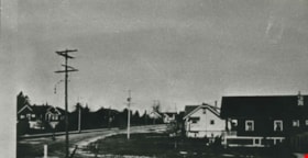
Davis family neighbourhood
https://search.heritageburnaby.ca/link/archivedescription35610
- Repository
- City of Burnaby Archives
- Date
- 1929 (date of original), copied 1986
- Collection/Fonds
- Burnaby Historical Society fonds
- Description Level
- Item
- Physical Description
- 1 photograph : b&w ; 10.2 x 17.8 cm print
- Scope and Content
- Photograph of the neighbourhood where the Davis family lived, looking up Royal Oak Road at Imperial Street, taken from an upstairs room of the Davis home. Arthur Davis later built a corner house at 2345 Royal Oak, right next to house from which this photograph was taken.
- Repository
- City of Burnaby Archives
- Date
- 1929 (date of original), copied 1986
- Collection/Fonds
- Burnaby Historical Society fonds
- Subseries
- Pioneer Tales subseries
- Physical Description
- 1 photograph : b&w ; 10.2 x 17.8 cm print
- Description Level
- Item
- Record No.
- 204-468
- Access Restriction
- No restrictions
- Reproduction Restriction
- No known restrictions
- Accession Number
- BHS1988-03
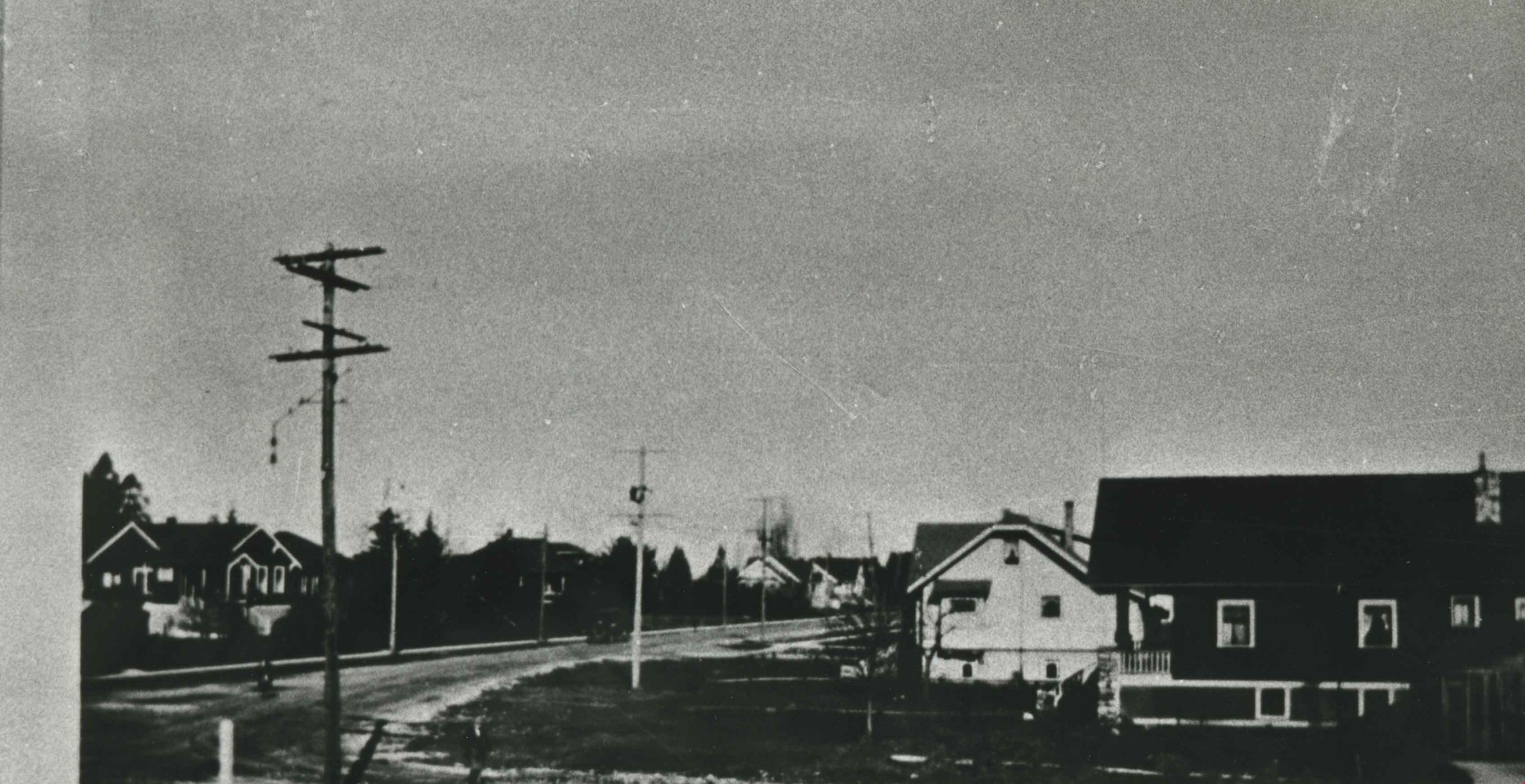
- Scope and Content
- Photograph of the neighbourhood where the Davis family lived, looking up Royal Oak Road at Imperial Street, taken from an upstairs room of the Davis home. Arthur Davis later built a corner house at 2345 Royal Oak, right next to house from which this photograph was taken.
- Subjects
- Geographic Features - Neighbourhoods
- Media Type
- Photograph
- Notes
- Title based on contents of photograph
- Photograph has been cropped
- Geographic Access
- Royal Oak Avenue
- Historic Neighbourhood
- Central Park (Historic Neighbourhood)
- Planning Study Area
- Windsor Area
Images