Narrow Results By
Subject
- Advertising Medium - Signs and Signboards 1
- Agriculture - Fruit and Berries 1
- Animals - Cats 1
- Arts - Paintings 1
- Buildings - Commercial 4
- Buildings - Commercial - General Stores 2
- Buildings - Commercial - Stores 1
- Buildings - Commercial - Train Stations 1
- Buildings - Industrial - Powerhouses 4
- Buildings - Recreational - Community Halls 1
- Buildings - Religious - Churches 2
- Buildings - Residential - Houses 6
Person / Organization
- A. MacKenzie and Company Jubilee Store 2
- Bailey, Gordon 1
- Bailey, Wilson 1
- Barber, Dora 3
- Bell, Georgina 4
- Bisset, Gladys 4
- Bond, Fred 3
- Bond, Lillian 3
- British Columbia Electric Railway Company 5
- Brown, Fern 1
- Brown, Marie Cornelia Morrow 2
- Central Park Agricultural Association and Farmers' Institute 1

Central Park Neighbourhood
https://search.heritageburnaby.ca/link/landmark723
- Repository
- Burnaby Heritage Planning
- Associated Dates
- 1891-1904
- Heritage Value
- Central Park was one of the first and fastest-growing communities in Burnaby. Located along the electric tram line and the Vancouver Road (Kingsway), it was also chosen for a government settlement project referred to as the Central Park Small Holdings. The lands held by the Provincial Government were subdivided and sold around 1894 and by 1899 the settlement was large enough to warrant the construction of an Anglican Church there.
- Historic Neighbourhood
- Central Park (Historic Neighbourhood)
- Planning Study Area
- Maywood Area
Images


Central Park Neighbourhood
https://search.heritageburnaby.ca/link/landmark751
- Repository
- Burnaby Heritage Planning
- Associated Dates
- 1905-1924
- Heritage Value
- In 1906, Maxwell Smith, President of the Central Park Farmer's Institute gave a speech in which he commented on the growth of this district and its ideal location during the boom years after 1905. He said: "Central Park is destined to become the epicentre of a great commercial metropolis, when Vancouver and New Westminster will have both expanded and prospered until they meet and fill up the intervening distances with residences of a new city, greater than few can now imagine, even in their wildest flights of fancy...we are proud of the two cities that lie on either side of us but they are, but mere hamlets compared with the great city that is to be on this peninsula. The time is coming when there will be one vast city, one commercial metropolis, and Central Park will be the heart of it."
- Historic Neighbourhood
- Central Park (Historic Neighbourhood)
- Planning Study Area
- Maywood Area
Images

![Kingsway at Central Park, [1908] (date of original) thumbnail](/media/hpo/_Data/_Archives_Images/_Unrestricted/251/293-001.jpg?width=280)
Kingsway at Central Park
https://search.heritageburnaby.ca/link/archivedescription36540
- Repository
- City of Burnaby Archives
- Date
- [1908] (date of original)
- Collection/Fonds
- Burnaby Historical Society fonds
- Description Level
- Item
- Physical Description
- 1 photograph : b&w ; 10 x 11.5 cm print
- Scope and Content
- Photograph of men driving horse-drawn carriages down Kingsway, east of Boundary Road. The Central Park Presbyterian Church is visible on the left, with Central Park on the right.
- Repository
- City of Burnaby Archives
- Date
- [1908] (date of original)
- Collection/Fonds
- Burnaby Historical Society fonds
- Subseries
- John DeForest subseries
- Physical Description
- 1 photograph : b&w ; 10 x 11.5 cm print
- Description Level
- Item
- Record No.
- 293-001
- Access Restriction
- No restrictions
- Reproduction Restriction
- No known restrictions
- Accession Number
- BHS1992-30
- Scope and Content
- Photograph of men driving horse-drawn carriages down Kingsway, east of Boundary Road. The Central Park Presbyterian Church is visible on the left, with Central Park on the right.
- Media Type
- Photograph
- Notes
- Title based on contents of photograph
- Geographic Access
- Central Park
- Kingsway
- Historic Neighbourhood
- Central Park (Historic Neighbourhood)
- Planning Study Area
- Maywood Area
Images
![Kingsway at Central Park, [1908] (date of original) thumbnail](/media/hpo/_Data/_Archives_Images/_Unrestricted/251/293-001.jpg)

Topping a tree near Central Park
https://search.heritageburnaby.ca/link/archivedescription37280
- Repository
- City of Burnaby Archives
- Date
- 1904
- Collection/Fonds
- Burnaby Historical Society fonds
- Description Level
- Item
- Physical Description
- 1 photograph : sepia toned ; 21 x 26.5 cm
- Scope and Content
- Photograph of a man "topping" a large tree in the area near Central Park and Boundary Road.
- Repository
- City of Burnaby Archives
- Date
- 1904
- Collection/Fonds
- Burnaby Historical Society fonds
- Subseries
- Norah Code subseries
- Physical Description
- 1 photograph : sepia toned ; 21 x 26.5 cm
- Description Level
- Item
- Record No.
- 345-001
- Access Restriction
- No restrictions
- Reproduction Restriction
- No known restrictions
- Accession Number
- BHS1997-05
- Scope and Content
- Photograph of a man "topping" a large tree in the area near Central Park and Boundary Road.
- Media Type
- Photograph
- Photographer
- Code, Norah
- Notes
- Title based on contents of photograph
- Photographs in this collection were taken and compiled by Norah Code, former editor of the "Burnaby Courier" newspaper during the course of her work for the newspaper. A note with the file indicates that the man in the tree may be Ms. Code's father but his name is not provided.
- Geographic Access
- Boundary Road
- Central Park
- Historic Neighbourhood
- Central Park (Historic Neighbourhood)
- Planning Study Area
- Maywood Area
Images


Joseph Clarke House
https://search.heritageburnaby.ca/link/landmark505
- Repository
- Burnaby Heritage Planning
- Description
- The Joseph Clarke House is a two and one-half storey, wood-frame house, with shingle siding, a front-gabled roof and a full open front verandah. It is located on Jersey Avenue within the Central Park neighbourhood of Burnaby.
- Associated Dates
- 1909
- Formal Recognition
- Heritage Designation, Community Heritage Register
- Other Names
- Joseph & Ellen Clarke House, Clarke Residence
- Street View URL
- Google Maps Street View
- Repository
- Burnaby Heritage Planning
- Other Names
- Joseph & Ellen Clarke House, Clarke Residence
- Geographic Access
- Jersey Avenue
- Sandell Street
- Associated Dates
- 1909
- Formal Recognition
- Heritage Designation, Community Heritage Register
- Enactment Type
- By-law No. 11930
- Enactment Date
- 29/08/2005
- Description
- The Joseph Clarke House is a two and one-half storey, wood-frame house, with shingle siding, a front-gabled roof and a full open front verandah. It is located on Jersey Avenue within the Central Park neighbourhood of Burnaby.
- Heritage Value
- Built circa 1909 for Central Park farmer Joseph Clarke (1851-1936) and his wife, Ellen (1864-1938), this Edwardian-era farm house is valued for its vernacular design, which demonstrates the utilitarian nature of working-class housing during the boom years prior to the First World War. The Joseph Clarke House is additionally valued for its link with the development of the Central Park neighbourhood during the Edwardian era. The advent of the Central Park interurban rail line in 1892, operated by the B.C. Electric Company, connected the area to Vancouver and led to its suburban development. This is one of the oldest surviving houses in the Central Park neighbourhood. It was designated as a municipal heritage site in 2005 and rehabilitated as part of the adjacent multi-family townhouse and apartment redevelopment.
- Defining Elements
- Key elements that define the heritage character of the Joseph Clarke House include its: - location on Jersey Avenue in the Central Park neighbourhood - residential form, scale and massing as expressed by its two and one-half storey height with rectangular plan, front bay window and front-gabled roof - wood-frame construction - Edwardian era detailing such as the open front verandah, asymmetrical front entrance, glazed front door with sidelights and triangular eave brackets
- Historic Neighbourhood
- Central Park (Historic Neighbourhood)
- Planning Study Area
- Garden Village Area
- Function
- Primary Historic--Single Dwelling
- Primary Current--Single Dwelling
- Community
- Burnaby
- Cadastral Identifier
- P.I.D. 027-101-428
- Boundaries
- The Joseph Clarke House is comprised of a single residential lot located at 5575 Jersey Avenue, Burnaby.
- Area
- 2370
- Contributing Resource
- Building
- Ownership
- Private
- Documentation
- City of Burnaby Planning and Building Department, Heritage Site Files
- Names
- Clarke, Joseph
- Clarke, Ellen
- Street Address
- 5575 Jersey Avenue
- Street View URL
- Google Maps Street View
Images


St. John the Divine Anglican Church
https://search.heritageburnaby.ca/link/landmark514
- Repository
- Burnaby Heritage Planning
- Description
- St. John the Divine Anglican Church is a landmark wood-frame Gothic Revival church, with Gothic windows and spire. It is located on Kingsway, one of Burnaby’s main commercial thoroughfares, near the SkyTrain transit line and across the street from Central Park.
- Associated Dates
- 1905
- Formal Recognition
- Community Heritage Register
- Street View URL
- Google Maps Street View
- Repository
- Burnaby Heritage Planning
- Geographic Access
- Kingsway
- Associated Dates
- 1905
- Formal Recognition
- Community Heritage Register
- Enactment Type
- Council Resolution
- Enactment Date
- 09/06/2003
- Description
- St. John the Divine Anglican Church is a landmark wood-frame Gothic Revival church, with Gothic windows and spire. It is located on Kingsway, one of Burnaby’s main commercial thoroughfares, near the SkyTrain transit line and across the street from Central Park.
- Heritage Value
- St. John the Divine Anglican Church is valued as a symbol of the traditions of early Burnaby pioneers and as the oldest surviving church building in the city. Established in 1899, St. John was the first church in the community and was located at a prominent intersection of the old Vancouver-Westminster Road (now Kingsway) and the British Columbia Electric Railway’s interurban station at Central Park. This prominent intersection of the road and rail developed as the town centre of the Central Park district. The first St. John church was destroyed by fire, and was rebuilt at the same location in 1904-05. This church is additionally significant for its association with prominent local architect Joseph Henry Bowman (1864-1943) who emigrated from England in 1888. Bowman was a member of the parish, and designed both the first church and its subsequent replacement. Bowman’s prolific career embraced many stylistic changes and technological advances, and this church is a surviving example of one of his rare religious commissions. The design of the new church's nave and vestry was based on the Gothic Revival style of Christ Church Anglican in Surrey, B.C., which had been the former church of St. John’s incumbent Rev. William Bell. Evolving over time as the congregation grew, the church received a number of early additions, and in 1953 was substantially renovated and enlarged through a new design by Vancouver architect Ross Lort. The original church nave was separated from the tower and turned to allow for a large addition. The congregation relocated to a new church in 1998, and at that time removed the church's memorial windows, leaving behind a number of the original art glass windows installed in the 1920s. The church building was renovated in 2004-05, and surviving original elements were retained and restored, including of the original church tower and interior chancel ceiling. A valued feature of the building is the original cast iron church bell that remains in the tower. It was purchased by the children of the congregation in 1912, and in 1924 was rededicated on Armistice Day as a memorial to Burnaby resident Lt. James Donald McRae Reid, who died in the First World War.
- Defining Elements
- Key elements that define the heritage character of St. John the Divine Anglican Church include its: - location on the north side of Kingsway, opposite Central Park - ecclesiastical form, scale and massing as expressed by the offset tower and tall, gabled roof - tower with its original horizontal wooden drop siding, bellcast square roof with octagonal drum above and bellcast octagonal spire - cedar shingle roof cladding - metal cross at peak of spire - Gothic Revival details such as: Gothic lancet windows with leaded stained glass panels; Gothic entrance door at the base of the tower; pointed-arch louvers in the tower; and exterior gable end scissor-trusses - interior features such as wooden scissor-trusses with diagonal fir tongue and groove panelling on the ceiling above, fir tongue-and-groove panelling on the wall of the nave, and original cedar and fir pews and altar rails - cast iron bell in tower
- Historic Neighbourhood
- Central Park (Historic Neighbourhood)
- Planning Study Area
- Garden Village Area
- Architect
- Joesph Henry Bowman
- Function
- Primary Historic--Place of Worship
- Primary Current--Place of Worship
- Community
- Burnaby
- Cadastral Identifier
- 003-398-871
- Boundaries
- St. John the Divine Anglican Church is comprised of a single institutional lot located at 3891 Kingway, Burnaby.
- Area
- 3486.66
- Contributing Resource
- Building
- Ownership
- Private
- Street Address
- 3891 Kingsway
- Street View URL
- Google Maps Street View
Images


Thomas & Ellen Sanderson Residence
https://search.heritageburnaby.ca/link/landmark644
- Repository
- Burnaby Heritage Planning
- Description
- Residential building.
- Associated Dates
- 1905
- Street View URL
- Google Maps Street View
- Repository
- Burnaby Heritage Planning
- Geographic Access
- Inman Avenue
- Associated Dates
- 1905
- Description
- Residential building.
- Heritage Value
- The Sandersons were pioneer settlers in the Central Park area, arriving in Burnaby in 1904. Thomas Sanderson (1878-1936) was born in Morningside, Scotland and immigrated to British Columbia in 1899. In Vancouver in 1903, he married Ellen Jane Garvin (1883-1965), a native of Sherbrooke, Quebec. Thomas was chief of the Accounting Department at Hastings Mill, and served as Reeve of Burnaby in 1919 and 1920. One of his sons, Thomas, was a long-time teacher in Burnaby. The Sandersons’ house was built in 1905 as a small Edwardian bungalow but was extensively remodelled in the 1920s and is a fine example of the Craftsman style and today remains in good condition. Typical of the Late Craftsman style, the house has a front gabled roof, triangular eave brackets, tapered window surrounds and a mix of textural finishes, including shingles and lapped siding.
- Locality
- Central Park
- Historic Neighbourhood
- Central Park (Historic Neighbourhood)
- Planning Study Area
- Garden Village Area
- Area
- 884.53
- Contributing Resource
- Building
- Ownership
- Private
- Street Address
- 5457 Inman Avenue
- Street View URL
- Google Maps Street View
Images


James & Agnes Smith Residence
https://search.heritageburnaby.ca/link/landmark601
- Repository
- Burnaby Heritage Planning
- Description
- Residential building.
- Associated Dates
- 1907
- Street View URL
- Google Maps Street View
- Repository
- Burnaby Heritage Planning
- Geographic Access
- Royal Oak Avenue
- Associated Dates
- 1907
- Description
- Residential building.
- Heritage Value
- During the Edwardian era, the western provinces were experiencing unprecedented population growth, and in response, in 1904 the Vancouver-based B.C. Mills, Timber and Trading Company patented a modular prefabricated building system that could be adapted to provide everything from modest one-room cottages to churches, schools and banks. Wall panels were assembled from the short mill ends of lumber and siding, until then just waste material that piled up in the millyard. These panels were bolted together on site, with the joints between the panels covered by distinctive vertical battens. Wall panels were assembled at the mill, pre-painted, and packaged with the other components and the instructions necessary to assemble the building. The disassembled building was then shipped to the waiting customer. As western settlements became established, labour and materials were more freely available and local construction companies could be more competitive in their costs. By 1910, this prefabricated system was rendered obsolete. The Smith Residence is a beautifully-preserved example of a B.C. Mills house, and is one of the models that featured a gambrel roof and a full open front verandah. This house was built by local contractor Mr. MacLean for James Smith, a ship’s engineer on the Empress of Japan, and his wife, Agnes. Agnes Smith continued to live here after her husband’s death and sold the house and property in the late 1920s with two of the acres being purchased by her daughter, Grace and husband Henry Pletcher to build a neighbouring house.
- Locality
- Central Park
- Historic Neighbourhood
- Central Park (Historic Neighbourhood)
- Planning Study Area
- Oakalla Area
- Area
- 1147.85
- Contributing Resource
- Building
- Ownership
- Private
- Street Address
- 6186 Royal Oak Avenue
- Street View URL
- Google Maps Street View
Images


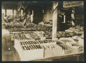
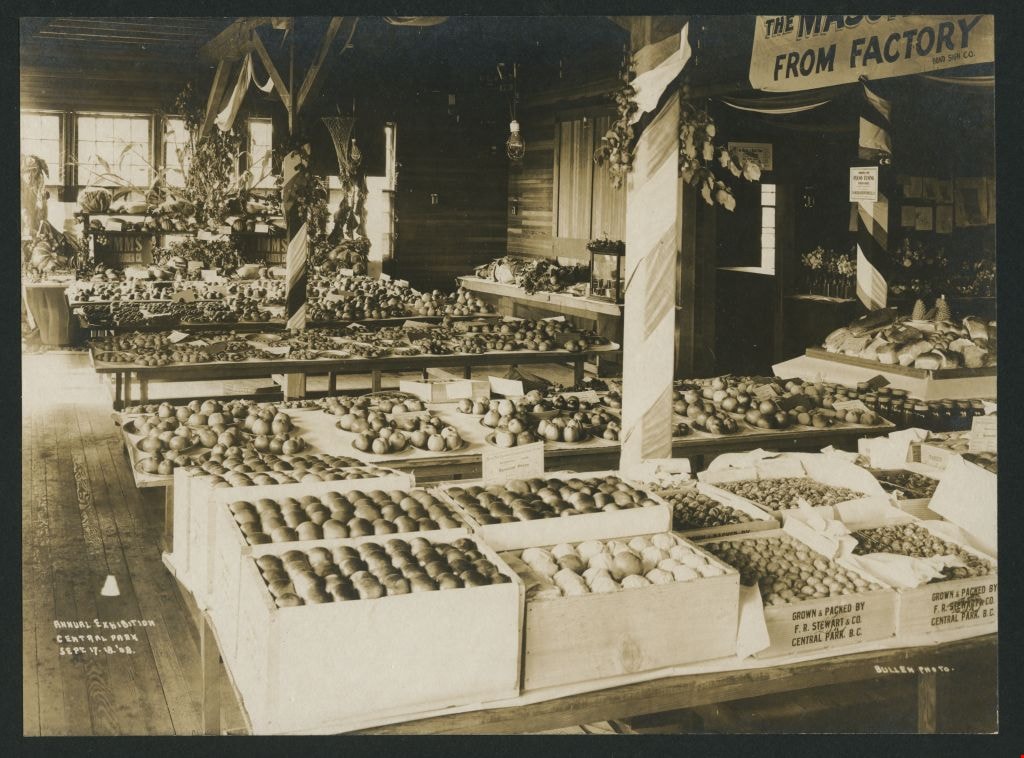
Annual Exhibition
https://search.heritageburnaby.ca/link/museumdescription1170
- Repository
- Burnaby Village Museum
- Date
- September 1908
- Collection/Fonds
- Burnaby Village Museum Photograph collection
- Description Level
- Item
- Physical Description
- 1 photograph : sepia ; 11.5 x 15.5 cm mounted on card 20 x 25 cm
- Scope and Content
- Photograph of fruit displays at the Central Park Annual Exhibition which took place from September 17 to 18, 1908. The fruits in crates or plates are displayed on tables. Also visible in other sections of the room are floral displays and baked goods. Some of the wooden crates on the table in the fo…
- Repository
- Burnaby Village Museum
- Collection/Fonds
- Burnaby Village Museum Photograph collection
- Description Level
- Item
- Physical Description
- 1 photograph : sepia ; 11.5 x 15.5 cm mounted on card 20 x 25 cm
- Scope and Content
- Photograph of fruit displays at the Central Park Annual Exhibition which took place from September 17 to 18, 1908. The fruits in crates or plates are displayed on tables. Also visible in other sections of the room are floral displays and baked goods. Some of the wooden crates on the table in the foreground of the photograph include insignia: "Grown & Packed by F.R. Stewart & Co. Central Park B.C.".
- Geographic Access
- Central Park
- Accession Code
- BV993.45.2
- Access Restriction
- No restrictions
- Reproduction Restriction
- No known restrictions
- Date
- September 1908
- Media Type
- Photograph
- Related Material
- For another print of the same image, see BV998.30.1
- Scan Resolution
- 600
- Scan Date
- 01-Jun-09
- Scale
- 100
- Photographer
- Bullen, Harry Elder
- Notes
- Continuation of title: "... CENTRAL PARK/ SEPT 17-18. '08."
- Photographer's annotation reads: "BULLEN PHOTO"
Images

Kingsway
https://search.heritageburnaby.ca/link/archivedescription35874
- Repository
- City of Burnaby Archives
- Date
- 1900 (date of original), copied 1986
- Collection/Fonds
- Burnaby Historical Society fonds
- Description Level
- Item
- Physical Description
- 1 photograph : b&w ; 12.7 x 17.8 cm print
- Scope and Content
- Photograph of Kingsway (then Westminster Road), looking east from Boundary Road near Central Park. Included in the photograph; Central Park Presbyterian Church, Masonic Hall and Reid's Hall.
- Repository
- City of Burnaby Archives
- Date
- 1900 (date of original), copied 1986
- Collection/Fonds
- Burnaby Historical Society fonds
- Subseries
- Pioneer Tales subseries
- Physical Description
- 1 photograph : b&w ; 12.7 x 17.8 cm print
- Description Level
- Item
- Record No.
- 204-733
- Access Restriction
- No restrictions
- Reproduction Restriction
- No known restrictions
- Accession Number
- BHS1988-03
- Scope and Content
- Photograph of Kingsway (then Westminster Road), looking east from Boundary Road near Central Park. Included in the photograph; Central Park Presbyterian Church, Masonic Hall and Reid's Hall.
- Subjects
- Buildings - Recreational - Community Halls
- Buildings - Religious - Churches
- Geographic Features - Roads
- Media Type
- Photograph
- Notes
- Title based on contents of photograph
- Geographic Access
- Westminster Avenue
- Kingsway
- Street Address
- 3777 Kingsway
- Historic Neighbourhood
- Central Park (Historic Neighbourhood)
- Planning Study Area
- Garden Village Area
Images

![Grace McGhee, [1909] (date of original), copied 1986 thumbnail](/media/hpo/_Data/_Archives_Images/_Unrestricted/204/204-010.jpg?width=280)
Grace McGhee
https://search.heritageburnaby.ca/link/archivedescription35153
- Repository
- City of Burnaby Archives
- Date
- [1909] (date of original), copied 1986
- Collection/Fonds
- Burnaby Historical Society fonds
- Description Level
- Item
- Physical Description
- 1 photograph : b&w ; 12.7 x 17.8 cm print
- Scope and Content
- Photograph of Grace McGhee (nee George) at McKay station along the Central Park Interurban line.
- Repository
- City of Burnaby Archives
- Date
- [1909] (date of original), copied 1986
- Collection/Fonds
- Burnaby Historical Society fonds
- Subseries
- Pioneer Tales subseries
- Physical Description
- 1 photograph : b&w ; 12.7 x 17.8 cm print
- Description Level
- Item
- Record No.
- 204-010
- Access Restriction
- No restrictions
- Reproduction Restriction
- No known restrictions
- Accession Number
- BHS1988-03
- Scope and Content
- Photograph of Grace McGhee (nee George) at McKay station along the Central Park Interurban line.
- Media Type
- Photograph
- Notes
- Title based on contents of photograph
- Geographic Access
- McKay Avenue
- Central Park Interurban line
- Historic Neighbourhood
- Central Park (Historic Neighbourhood)
- Planning Study Area
- Maywood Area
Images
![Grace McGhee, [1909] (date of original), copied 1986 thumbnail](/media/hpo/_Data/_Archives_Images/_Unrestricted/204/204-010.jpg)
Patterson family subseries
https://search.heritageburnaby.ca/link/archivedescription32
- Repository
- City of Burnaby Archives
- Date
- 1898-1952
- Collection/Fonds
- Burnaby Historical Society fonds
- Description Level
- Subseries
- Physical Description
- Textual records and photographs
- Scope and Content
- Subseries consists of documents and photographs pertaining to the Patterson family.
- Repository
- City of Burnaby Archives
- Date
- 1898-1952
- Collection/Fonds
- Burnaby Historical Society fonds
- Subseries
- Patterson family subseries
- Physical Description
- Textual records and photographs
- Description Level
- Subseries
- Accession Number
- BHS1986-19
- BHS1986-20
- BHS1988-13
- BHS1995-16
- BHS1996-05
- BHS1996-11
- Scope and Content
- Subseries consists of documents and photographs pertaining to the Patterson family.
- History
- Frances Mabel "May" Webb was born in Cradley, England on December 5, 1872. She sailed from England to Victoria, BC with her parents, Joseph William Webb and Frances Jane Webb (nee Yapp) on the SS Lake Winnipeg in 1889. One of the few possessions that she brought with her was an old wood-rimmed bicycle which she found quite useful after her move to Burnaby. She would ride it all the way from Patterson’s Trail and Westminster Road (today’s Patterson Avenue and Kingsway) to the Woodward’s store in Vancouver where she would place her grocery order. She packed a pearl handled revolver with her in order to scare any bears she might see along her ride. In 1890, Frances married Dugald Campbell Patterson (b. 1860, d. 1931) in Victoria, BC. In 1894, the couple built a pioneer homestead and farm on five acres at what would become the north east section of Central Park. Dugald founded Vulcan Iron Works (later Dominion Bridge Company) in New Westminister in 1903, and the couple settled in the Central Park district. By 1904, the family moved to the Edmonds district where in 1909 she operated the post office that her husband founded. In 1910, they began construction of a new house, complete with tennis courts and a gazebo, on 14 acres purchased for $720. The house is now located at 7106 18th Avenue and is a dedicated heritage building. The couple had seven children: William H. "Bill", Jean, Frances Mabel Lili., Dugald C. Jr, Mary, Charles Bruce, and Alice. The Pattersons were community-minded citizens that served Burnaby through their involvement with local municipal affairs and politics. In 1909, Dugald became the first postmaster of Edmonds. He also served as a School Trustee from 1912-13 and was one of the first residents to lobby Burnaby City Council to preserve the local ravines as parks. They also helped build the Central Park Presbyterian Church, along with other pioneer families. The family name is remembered and honoured by the naming of Patterson Avenue and the Patterson SkyTrain Station located in the Metrotown area. Frances Mabel assisted her husband with an insurance and real estate company that he founded in Burnaby and New Westminster. This experience would prove invaluable, as she would later become an insurance agent for the Wawanesa Insurance Company (founded in 1896). Frances never owned an automobile, so she met her insurance clients all over Burnaby, New Westminster and Vancouver by using the Lower Mainland’s street car system. The insurance profession continued to provide her with a steady income long after her husband’s death. Frances Mabel died in New Westminster, BC on August 30, 1960. Frances Mabel Lili Patterson was born on June 9, 1905 and was the fifth child born to Dugald Campbell and Frances Mabel Patterson. She became the first PBX switchboard operator for the Municipality of Burnaby in the early 1920’s. PBX, or Private Branch Exchange, was the term used for an internal telephone system. Frances later became president of the Professional Women’s Association of New Westminster, and volunteered her time with the May Day celebrations in New Westminster. She was also a dedicated member of the Rebekah Lodge (the women’s division of the Independent Order of Odd Fellows). While in the lodge, she met her future husband, Walter Duke and they married on July 12, 1939. They couple moved to Wenatchee, Washington after getting married, and Frances relocated to Victoria after her husband died. Frances died on January 13, 1974. Doreen Nettie Patterson was born December 12, 1927, the youngest daughter of Charles Bruce Patterson and Elva Eleanore Patterson (nee Elliott). At age 23, Doreen became the first woman from BC to enlist in the new Women’s Royal Canadian Naval Service and by the fall of 1951, she had become a Wren in the Royal Canadian Navy. She received her basic training at HMCS Cornwallis and became a radio intelligence operator for the wireless communications base at Naval Radio Station Coverdale near Moncton, New Brunswick. In 1953, she was chosen to serve a term at the naval base in Churchill, Manitoba. She was one of only eleven women to ever serve there. After her career in the navy, Doreen worked in the accounting division for Simpsons-Sears in Burnaby near her grandparent’s original family home at Patterson Avenue and Kingsway. Doreen married Gerard Reitsma on August 18, 1960. Doreen died on April 30, 2000.
- Media Type
- Textual Record
- Photograph
- Notes
- Title based on contents of subseries
- PC171, PC213, PC322, PC326, MSS024, MSS039
Burnaby Public Library photograph subseries
https://search.heritageburnaby.ca/link/archivedescription58147
- Repository
- City of Burnaby Archives
- Date
- 1908-1973
- Collection/Fonds
- Burnaby Historical Society fonds
- Description Level
- Subseries
- Physical Description
- Photographs
- Scope and Content
- Subseries consists of historical photographs of Burnaby collected by the Burnaby Public Library.
- Repository
- City of Burnaby Archives
- Date
- 1908-1973
- Collection/Fonds
- Burnaby Historical Society fonds
- Physical Description
- Photographs
- Description Level
- Subseries
- Accession Number
- BHS1989-22
- Scope and Content
- Subseries consists of historical photographs of Burnaby collected by the Burnaby Public Library.
- History
- Burnaby's first library was founded in 1927 as the North Burnaby Library Association. Its first library building was established in 1935 on Hastings Street. In 1954, Burnaby enacted Bylaw No. 3522 to establish the Burnaby Public Library (BPL) and in 1957 BPL merged with the North Burnaby Library Association. BPL's first permanent library was the McGill branch, built in North Burnaby in 1961 and named after North Burnaby Library Association volunteer Grace McGill. Following McGill, BPL then established the Kingsway branch, Central Park branch, and Cameron branch. Central Park was replaced by the Bob Prittie Metrotown branch in 1991 and Kingsway with the Tommy Douglas branch in 2009.
- Media Type
- Photograph
- Creator
- Burnaby Public Library
- Notes
- PC225, PC226, PC227, PC228, PC229, PC230, PC231, PC232, PC322, and PC427
- Title based on creator of subseries
![Burnaby Substation, [September 1907] thumbnail](/media/hpo/_Data/_Archives_Images/_Unrestricted/251/293-002.jpg?width=280)
Burnaby Substation
https://search.heritageburnaby.ca/link/archivedescription36541
- Repository
- City of Burnaby Archives
- Date
- [September 1907]
- Collection/Fonds
- Burnaby Historical Society fonds
- Description Level
- Item
- Physical Description
- 1 photograph : b&w postcard ; 7.5 x 13 cm
- Scope and Content
- Photographic postcard of the British Columbia Electric Railway Company's Burnaby Substation that was built in 1903 and put into operation to receive and distribute power from the B.C.E.R. Buntzen Lake power dam. The electric lines came across the inlet at Barnet, along the Barnet-Hastings Road to S…
- Repository
- City of Burnaby Archives
- Date
- [September 1907]
- Collection/Fonds
- Burnaby Historical Society fonds
- Subseries
- John DeForest subseries
- Physical Description
- 1 photograph : b&w postcard ; 7.5 x 13 cm
- Description Level
- Item
- Record No.
- 293-002
- Access Restriction
- No restrictions
- Reproduction Restriction
- No known restrictions
- Accession Number
- BHS1992-30
- Scope and Content
- Photographic postcard of the British Columbia Electric Railway Company's Burnaby Substation that was built in 1903 and put into operation to receive and distribute power from the B.C.E.R. Buntzen Lake power dam. The electric lines came across the inlet at Barnet, along the Barnet-Hastings Road to Sperling Avenue (built for this project and called Pole Line Road) and then south to this site at the corner of Griffiths and the old Central Park interurban line (later this section was called the Highland Park line). This substation was constructed to convert the alternating current being delivered from the Buntzen power plant to direct current for the operation of the tram cars operating on the Central Park interurban route. The new brick substation replaced the wood fed steam powered 1891 Powerhouse that operated south of this site, across the tracks until its closure on May 31,1905. It was demolised in the late 1920s. This brick substation originally known as the Burnaby Substation, eventually became known as the Newell Substation. The original brick building was replaced by a new structure in 1930, which was demolished in the 1960s in favour of the open field substation that continues to operate on the same site today at 7260 Griffiths Avenue.
- Subjects
- Buildings - Industrial - Powerhouses
- Media Type
- Photograph
- Notes
- Title based on contents of photograph
- Geographic Access
- Griffiths Avenue
- Historic Neighbourhood
- Edmonds (Historic Neighbourhood)
- Planning Study Area
- Stride Avenue Area
Images
![Burnaby Substation, [September 1907] thumbnail](/media/hpo/_Data/_Archives_Images/_Unrestricted/251/293-002.jpg)
George Jeffery subseries
https://search.heritageburnaby.ca/link/archivedescription57762
- Repository
- City of Burnaby Archives
- Date
- 1899-1959
- Collection/Fonds
- Burnaby Historical Society fonds
- Description Level
- Subseries
- Physical Description
- Textual records and photographs
- Scope and Content
- Subseries consists of personal and professional records, notebooks and papers pertaining to George Jeffery. Also included in the subseries are May Day programmes, invitations, and photographs of May Day, Diamond Jubilee of Confederation celebrations, and the Burnaby Police department.
- Repository
- City of Burnaby Archives
- Date
- 1899-1959
- Collection/Fonds
- Burnaby Historical Society fonds
- Subseries
- George Jeffery subseries
- Physical Description
- Textual records and photographs
- Description Level
- Subseries
- Accession Number
- BHS2007-04
- Scope and Content
- Subseries consists of personal and professional records, notebooks and papers pertaining to George Jeffery. Also included in the subseries are May Day programmes, invitations, and photographs of May Day, Diamond Jubilee of Confederation celebrations, and the Burnaby Police department.
- History
- George Jeffery was a well-respected Burnaby police constable, having served first as a solider. Upon joining the police force in 1912, he was appointed to patrol the Central Park district, a position he held for 22 years. From his experiences confronting young shoplifters, he determined the reason groups of boys were getting into trouble was due to a lack of recreational activities on offer. He established the Burnaby Athletics Association in an old barn behind the Royal Oak Hotel to combat this, turning it into a competitive boxing ring and gym. George and his wife Harriet lived most of their married life in Central Park district with their three daughters: Patricia, a teacher in Burnaby prior to her marriage; Winnifred, Burnaby's 1929 May Queen; and Elsie who excelled at badminton. Patricia married William Poole; Winnifred married Fred Shaughnessy; and Elsie married Art Winteford. In 1935, when the BC Provincial police replaced the Burnaby Police, George quit the force in order to stay in Burnaby and worked at Oakalla Prison farm. He retired in 1945.
- Media Type
- Textual Record
- Photograph
- Creator
- Jeffery, George
- Notes
- Title based on contents of subseries
- MSS013, PC013
![Interior of the Burnaby Substation, [September 1908] thumbnail](/media/hpo/_Data/_Archives_Images/_Unrestricted/251/293-003.jpg?width=280)
Interior of the Burnaby Substation
https://search.heritageburnaby.ca/link/archivedescription36542
- Repository
- City of Burnaby Archives
- Date
- [September 1908]
- Collection/Fonds
- Burnaby Historical Society fonds
- Description Level
- Item
- Physical Description
- 1 photograph : b&w postcard ; 7.5 x 13 cm
- Scope and Content
- Photographic postcard of the interior of the British Columbia Electric Railway Company's Burnaby Substation that was built in 1903 and put into operation to receive and distribute power from the B.C.E.R. Buntzen Lake power dam. The electric lines came across the inlet at Barnet, along the Barnet-Ha…
- Repository
- City of Burnaby Archives
- Date
- [September 1908]
- Collection/Fonds
- Burnaby Historical Society fonds
- Subseries
- John DeForest subseries
- Physical Description
- 1 photograph : b&w postcard ; 7.5 x 13 cm
- Description Level
- Item
- Record No.
- 293-003
- Access Restriction
- No restrictions
- Reproduction Restriction
- No known restrictions
- Accession Number
- BHS1992-30
- Scope and Content
- Photographic postcard of the interior of the British Columbia Electric Railway Company's Burnaby Substation that was built in 1903 and put into operation to receive and distribute power from the B.C.E.R. Buntzen Lake power dam. The electric lines came across the inlet at Barnet, along the Barnet-Hastings Road to Sperling Avenue (built for this project and called Pole Line Road) and then south to this site at the corner of Griffiths and the old Central Park interurban line (later this section was called the Highland Park line). This substation was constructed to convert the alternating current being delivered from the Buntzen power plant to direct current for the operation of the tram cars operating on the Central Park interurban route. The new brick substation replaced the wood fed steam powered 1891 Powerhouse that operated south of this site, across the tracks until its closure on May 31,1905. It was demolised in the late 1920s. This brick substation originally known as the Burnaby Substation, eventually became known as the Newell Substation. The original brick building was replaced by a new structure in 1930, which was demolished in the 1960s in favour of the open field substation that continues to operate on the same site today at 7260 Griffiths Avenue.
- Subjects
- Buildings - Industrial - Powerhouses
- Media Type
- Photograph
- Notes
- Title based on contents of photograph
- Geographic Access
- Griffiths Avenue
- Historic Neighbourhood
- Edmonds (Historic Neighbourhood)
- Planning Study Area
- Stride Avenue Area
Images
![Interior of the Burnaby Substation, [September 1908] thumbnail](/media/hpo/_Data/_Archives_Images/_Unrestricted/251/293-003.jpg)
![Interior of the Burnaby Substation, [September 1908] thumbnail](/media/hpo/_Data/_Archives_Images/_Unrestricted/251/293-004.jpg?width=280)
Interior of the Burnaby Substation
https://search.heritageburnaby.ca/link/archivedescription36543
- Repository
- City of Burnaby Archives
- Date
- [September 1908]
- Collection/Fonds
- Burnaby Historical Society fonds
- Description Level
- Item
- Physical Description
- 1 photograph : b&w postcard ; 7.5 x 13 cm
- Scope and Content
- Photographic postcard of the interior of the British Columbia Electric Railway Company's Burnaby Substation that was built in 1903 and put into operation to receive and distribute power from the B.C.E.R. Buntzen Lake power dam. The electric lines came across the inlet at Barnet, along the Barnet-Ha…
- Repository
- City of Burnaby Archives
- Date
- [September 1908]
- Collection/Fonds
- Burnaby Historical Society fonds
- Subseries
- John DeForest subseries
- Physical Description
- 1 photograph : b&w postcard ; 7.5 x 13 cm
- Description Level
- Item
- Record No.
- 293-004
- Access Restriction
- No restrictions
- Reproduction Restriction
- No known restrictions
- Accession Number
- BHS1992-30
- Scope and Content
- Photographic postcard of the interior of the British Columbia Electric Railway Company's Burnaby Substation that was built in 1903 and put into operation to receive and distribute power from the B.C.E.R. Buntzen Lake power dam. The electric lines came across the inlet at Barnet, along the Barnet-Hastings Road to Sperling Avenue (built for this project and called Pole Line Road) and then south to this site at the corner of Griffiths and the old Central Park interurban line (later this section was called the Highland Park line). This substation was constructed to convert the alternating current being delivered from the Buntzen power plant to direct current for the operation of the tram cars operating on the Central Park interurban route. The new brick substation replaced the wood fed steam powered 1891 Powerhouse that operated south of this site, across the tracks until its closure on May 31,1905. It was demolised in the late 1920s. This brick substation originally known as the Burnaby Substation, eventually became known as the Newell Substation. The original brick building was replaced by a new structure in 1930, which was demolished in the 1960s in favour of the open field substation that continues to operate on the same site today at 7260 Griffiths Avenue.
- Subjects
- Buildings - Industrial - Powerhouses
- Media Type
- Photograph
- Notes
- Title based on contents of photograph
- Geographic Access
- Griffiths Avenue
- Historic Neighbourhood
- Edmonds (Historic Neighbourhood)
- Planning Study Area
- Stride Avenue Area
Images
![Interior of the Burnaby Substation, [September 1908] thumbnail](/media/hpo/_Data/_Archives_Images/_Unrestricted/251/293-004.jpg)

Interior of the Burnaby Substation
https://search.heritageburnaby.ca/link/archivedescription36544
- Repository
- City of Burnaby Archives
- Date
- 1907
- Collection/Fonds
- Burnaby Historical Society fonds
- Description Level
- Item
- Physical Description
- 1 photograph : sepia ; 12 x 17cm, mounted on board 22 x 27 cm
- Scope and Content
- Photograph of the interior of the British Columbia Electric Railway Company's Burnaby Substation that was built in 1903 and put into operation to receive and distribute power from the B.C.E.R. Buntzen Lake power dam. The electric lines came across the inlet at Barnet, along the Barnet-Hastings Road…
- Repository
- City of Burnaby Archives
- Date
- 1907
- Collection/Fonds
- Burnaby Historical Society fonds
- Subseries
- John DeForest subseries
- Physical Description
- 1 photograph : sepia ; 12 x 17cm, mounted on board 22 x 27 cm
- Description Level
- Item
- Record No.
- 293-005
- Access Restriction
- No restrictions
- Reproduction Restriction
- No known restrictions
- Accession Number
- BHS1992-30
- Scope and Content
- Photograph of the interior of the British Columbia Electric Railway Company's Burnaby Substation that was built in 1903 and put into operation to receive and distribute power from the B.C.E.R. Buntzen Lake power dam. The electric lines came across the inlet at Barnet, along the Barnet-Hastings Road to Sperling Avenue (built for this project and called Pole Line Road) and then south to this site at the corner of Griffiths and the old Central Park interurban line (later this section was called the Highland Park line). This substation was constructed to convert the alternating current being delivered from the Buntzen power plant to direct current for the operation of the tram cars operating on the Central Park interurban route. The new brick substation replaced the wood fed steam powered 1891 Powerhouse that operated south of this site, across the tracks until its closure on May 31,1905. It was demolised in the late 1920s. This brick substation originally known as the Burnaby Substation, eventually became known as the Newell Substation. The original brick building was replaced by a new structure in 1930, which was demolished in the 1960s in favour of the open field substation that continues to operate on the same site today at 7260 Griffiths Avenue.
- Subjects
- Buildings - Industrial - Powerhouses
- Media Type
- Photograph
- Notes
- Title based on contents of photograph
- Photographer's handwritten note (on the negative causing it to show) on recto of photograph reads: "Burnaby Substation/ B.C.E.R.C/O"
- Geographic Access
- Griffiths Avenue
- Historic Neighbourhood
- Edmonds (Historic Neighbourhood)
- Planning Study Area
- Stride Avenue Area
Images

Bancroft family subseries
https://search.heritageburnaby.ca/link/archivedescription63795
- Repository
- City of Burnaby Archives
- Date
- [1900]-1979
- Collection/Fonds
- Burnaby Historical Society fonds
- Description Level
- Subseries
- Physical Description
- Textual records and other materials
- Scope and Content
- Subseries consists of publications, correspondence and other miscellaneous papers relating to the Bancroft family's interests and work history. Topics include gardening, raising poultry, the Liberal government and the Royal Canadian Air Force. Also included in the subseries are photographs of the…
- Repository
- City of Burnaby Archives
- Date
- [1900]-1979
- Collection/Fonds
- Burnaby Historical Society fonds
- Subseries
- Bancroft family subseries
- Physical Description
- Textual records and other materials
- Description Level
- Subseries
- Accession Number
- BHS1986-44
- BHS2004-06
- Scope and Content
- Subseries consists of publications, correspondence and other miscellaneous papers relating to the Bancroft family's interests and work history. Topics include gardening, raising poultry, the Liberal government and the Royal Canadian Air Force. Also included in the subseries are photographs of the Bancroft family and friends and ephemera pertaining to agricultural farming and the air force.
- History
- Rose Croucher was born to Ann Eliza "Annie" (b. August 1861, d. 1962) and R. Coucher in January 1895. In 1907, the Croucher family moved to British Columbia. As a student, Rose studied geometrical drawing using Blair’s Canadian Drawing Series workbooks. On on February 21, 1914, Rose married James Oakes Bancroft in Vancouver, BC. Together they had three children: James A. (b. 1916 or 1917), Rosie (date unknown), and George E. (b. August 1927). The Bancroft family were poultry farmers throughout the early 1900s, transporting their farmed eggs from Burnaby to the Hudson’s Bay Company Vancouver using the British Columbia Electric Railway system. Rose Bancroft also served as Secretary-Treasurer of the Central Park Poultry Co-op Association in the 1920s until her husband's death in 1930 at the age of 42. In the late thirties and early forties, while James A. Bancroft was stationed in Calgary with the Royal Canadian Air Force, his younger siblings lived together with their mother and grandmother at 1963 21st Avenue in Burnaby. Rosie Bancroft studied French and English history in Social Studies in 1937; her brother George studied the seasons in General Science II in 1942. Rose died in 1965 at the age of 76.
- Media Type
- Textual Record
- Photograph
- Cartographic Material
- Creator
- Bancroft, Rose
- Notes
- MSS030, PC490, PC507, and MSS110
- Title based on creator and contents of subseries
Burnaby Scouts subseries
https://search.heritageburnaby.ca/link/archivedescription54956
- Repository
- City of Burnaby Archives
- Date
- 1909-1991
- Collection/Fonds
- Burnaby Historical Society fonds
- Description Level
- Subseries
- Physical Description
- Textual records and other material
- Scope and Content
- Subseries consists of the records of the Burnaby Scouts, including: personal and business correspondence, registration forms, group records, charters, awards, group minutes, newspaper clippings, training records, jamboree's, activities, and photographs from many of the regions members and the activ…
- Repository
- City of Burnaby Archives
- Date
- 1909-1991
- Collection/Fonds
- Burnaby Historical Society fonds
- Subseries
- Burnaby Scouts subseries
- Physical Description
- Textual records and other material
- Description Level
- Subseries
- Access Restriction
- Subject to FOIPPA
- Accession Number
- BHS1994-05
- Scope and Content
- Subseries consists of the records of the Burnaby Scouts, including: personal and business correspondence, registration forms, group records, charters, awards, group minutes, newspaper clippings, training records, jamboree's, activities, and photographs from many of the regions members and the activities in which they participated.
- History
- The inception of Scouting was the accomplishment of Lord Baden-Powell of Great Britain. His idea of training boys in the art of self-preservation, honesty, loyalty and good conduct has spread to most countries of the world. Scouting in Burnaby was originally a section of the Vancouver-Coast Region starting in 1910, called the Central Park Division. This was later divided in 1948 into North Burnaby, consisting of 26 groups and South Burnaby with 30 groups. It had grown to such an extent by 1957 that it became, although the smallest in area in Canada, an independent Region consisting of eight Districts of a total of 71 groups. By 1994, the decline in membership resulted in a reduction to three Districts.
- Media Type
- Photograph
- Textual Record
- Notes
- MSS100
- Title based on creator and contents of subseries