Narrow Results By
Subject
- Advertising Medium - Signs and Signboards 2
- Aerial Photographs 2
- Animals - Cats 1
- Animals - Dogs 3
- Animals - Horses 1
- Arts - Paintings 1
- Buildings 1
- Buildings - Civic 1
- Buildings - Civic - Fire Halls 1
- Buildings - Commercial 6
- Buildings - Commercial - Drive-In Theatres 1
- Buildings - Commercial - General Stores 2
Creator
- Barrowclough, G.A. 1
- Barrowclough, George Alfred 1
- Brown, William Thomas 3
- Burnaby Village Museum 1
- Code, Norah 1
- Digney, Andy 5
- Digney, Ernest Frank "Dig" 5
- Hill, Albert James 1
- Joesph Henry Bowman 1
- King, Basil 1
- Libby, Ralph 2
- Printed on back of postcard: "Pub. by Living Colour Advertising Agencies, 809 21st St., New West'r, BC - 526-6612" and "Made in Canada / Dexter Color, Canada Ltd., Cornwall, Ontario" 1
Matheson family home
https://search.heritageburnaby.ca/link/archivedescription37667
- Repository
- City of Burnaby Archives
- Date
- 1962 (date of original), copied 1991
- Collection/Fonds
- Burnaby Historical Society fonds
- Description Level
- Item
- Physical Description
- 1 photograph : b&w ; 3.3 x 5.4 cm print on contact sheet 20.2 x 25.3 cm
- Scope and Content
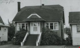
- Photograph of the Matheson family home at 6149 McKay Avenue (formerly numbered 2890 McKay Avenue). It was built in the spring of 1926.
- Repository
- City of Burnaby Archives
- Date
- 1962 (date of original), copied 1991
- Collection/Fonds
- Burnaby Historical Society fonds
- Subseries
- Burnaby Image Bank subseries
- Physical Description
- 1 photograph : b&w ; 3.3 x 5.4 cm print on contact sheet 20.2 x 25.3 cm
- Description Level
- Item
- Record No.
- 370-255
- Access Restriction
- No restrictions
- Reproduction Restriction
- No restrictions
- Accession Number
- BHS1999-03
- Scope and Content
- Photograph of the Matheson family home at 6149 McKay Avenue (formerly numbered 2890 McKay Avenue). It was built in the spring of 1926.
- Subjects
- Buildings - Residential - Houses
- Media Type
- Photograph
- Notes
- Title based on contents of photograph
- 1 b&w copy negative accompanying
- Negative has a pink cast
- Geographic Access
- McKay Avenue
- Street Address
- 6149 McKay Avenue
- Historic Neighbourhood
- Central Park (Historic Neighbourhood)
- Planning Study Area
- Maywood Area
Images

Michael Loynes
https://search.heritageburnaby.ca/link/archivedescription37664
- Repository
- City of Burnaby Archives
- Date
- 1963 (date of original), copied 1991
- Collection/Fonds
- Burnaby Historical Society fonds
- Description Level
- Item
- Physical Description
- 1 photograph : b&w ; 4.1 x 2.8 cm print on contact sheet 20.2 x 25.3 cm
- Scope and Content
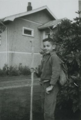
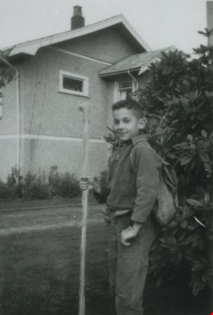
- Photograph of Michael Loynes with a large walking stick in the front yard 6131 Silver Avenue. The Coutts family home can be seen in the background.
- Repository
- City of Burnaby Archives
- Date
- 1963 (date of original), copied 1991
- Collection/Fonds
- Burnaby Historical Society fonds
- Subseries
- Burnaby Image Bank subseries
- Physical Description
- 1 photograph : b&w ; 4.1 x 2.8 cm print on contact sheet 20.2 x 25.3 cm
- Description Level
- Item
- Record No.
- 370-252
- Access Restriction
- No restrictions
- Reproduction Restriction
- No restrictions
- Accession Number
- BHS1999-03
- Scope and Content
- Photograph of Michael Loynes with a large walking stick in the front yard 6131 Silver Avenue. The Coutts family home can be seen in the background.
- Subjects
- Recreational Activities - Hiking
- Names
- Loynes, Michael "Mike"
- Media Type
- Photograph
- Notes
- Title based on contents of photograph
- 1 b&w copy negative accompanying
- Negative has a pink cast
- Geographic Access
- Silver Avenue
- Street Address
- 6131 Silver Avenue
- Historic Neighbourhood
- Central Park (Historic Neighbourhood)
- Planning Study Area
- Maywood Area
Images
Michael Loynes in Baseball Uniform
https://search.heritageburnaby.ca/link/archivedescription37666
- Repository
- City of Burnaby Archives
- Date
- 1964 (date of original), copied 1991
- Collection/Fonds
- Burnaby Historical Society fonds
- Description Level
- Item
- Physical Description
- 1 photograph : b&w ; 3.3 x 5.0 cm print on contact sheet 20.2 x 25.3 cm
- Scope and Content
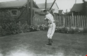
- Photograph of Michael Loynes in a baseball uniform and holding a bat at the back of 6131 Silver Avenue in the summer of 1964.
- Repository
- City of Burnaby Archives
- Date
- 1964 (date of original), copied 1991
- Collection/Fonds
- Burnaby Historical Society fonds
- Subseries
- Burnaby Image Bank subseries
- Physical Description
- 1 photograph : b&w ; 3.3 x 5.0 cm print on contact sheet 20.2 x 25.3 cm
- Description Level
- Item
- Record No.
- 370-254
- Access Restriction
- No restrictions
- Reproduction Restriction
- No restrictions
- Accession Number
- BHS1999-03
- Scope and Content
- Photograph of Michael Loynes in a baseball uniform and holding a bat at the back of 6131 Silver Avenue in the summer of 1964.
- Subjects
- Sports - Baseball
- Sports - Team Sports
- Names
- Loynes, Michael "Mike"
- Media Type
- Photograph
- Notes
- Title based on contents of photograph
- 1 b&w copy negative accompanying
- Negative has a pink cast
- Geographic Access
- Silver Avenue
- Street Address
- 6131 Silver Avenue
- Historic Neighbourhood
- Central Park (Historic Neighbourhood)
- Planning Study Area
- Maywood Area
Images

Michael Loynes with his bicycle
https://search.heritageburnaby.ca/link/archivedescription37665
- Repository
- City of Burnaby Archives
- Date
- Jul. 1963 (date of original), copied 1991
- Collection/Fonds
- Burnaby Historical Society fonds
- Description Level
- Item
- Physical Description
- 1 photograph : b&w ; 3.9 x 4.0 cm print on contact sheet 20.2 x 25.3 cm
- Scope and Content
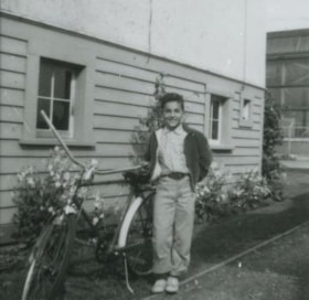
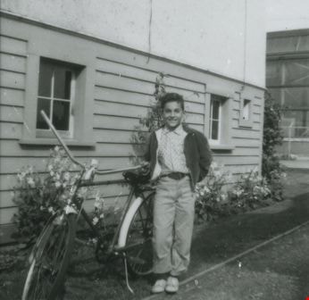
- Photograph of Michael Loynes standing beside a bicycle at the side of 6131 Silver Avenue. The Ford Motor plant is visible in the background.
- Repository
- City of Burnaby Archives
- Date
- Jul. 1963 (date of original), copied 1991
- Collection/Fonds
- Burnaby Historical Society fonds
- Subseries
- Burnaby Image Bank subseries
- Physical Description
- 1 photograph : b&w ; 3.9 x 4.0 cm print on contact sheet 20.2 x 25.3 cm
- Description Level
- Item
- Record No.
- 370-253
- Access Restriction
- No restrictions
- Reproduction Restriction
- No restrictions
- Accession Number
- BHS1999-03
- Scope and Content
- Photograph of Michael Loynes standing beside a bicycle at the side of 6131 Silver Avenue. The Ford Motor plant is visible in the background.
- Subjects
- Transportation - Bicycles
- Media Type
- Photograph
- Notes
- Title based on contents of photograph
- 1 b&w copy negative accompanying
- Negative has a pink cast
- Geographic Access
- Silver Avenue
- Street Address
- 6131 Silver Avenue
- Historic Neighbourhood
- Central Park (Historic Neighbourhood)
- Planning Study Area
- Maywood Area
Images
![Mike and Dennis Krewenchuk, [between 1958 and 196-] thumbnail](/media/hpo/_Data/_Archives_Images/_Unrestricted/580/582-002.jpg?width=280)
Mike and Dennis Krewenchuk
https://search.heritageburnaby.ca/link/archivedescription88413
- Repository
- City of Burnaby Archives
- Date
- [between 1958 and 196-]
- Collection/Fonds
- Krewenchuk family fonds
- Description Level
- Item
- Physical Description
- 1 photograph : b&w ; 9 x 13 cm
- Scope and Content
- Photograph of Mike (father) and Dennis (son) Krewenchuk seated on the flower bed of the Nelson Motel (also known as the Nelson Auto Court and Nelson Bungalow Court). The stairs to the motel office can be seen to the left with the wall of the building in behind them. The building served as the Krewe…
- Repository
- City of Burnaby Archives
- Date
- [between 1958 and 196-]
- Collection/Fonds
- Krewenchuk family fonds
- Physical Description
- 1 photograph : b&w ; 9 x 13 cm
- Description Level
- Item
- Record No.
- 582-002
- Access Restriction
- No restrictions
- Reproduction Restriction
- No restrictions
- Accession Number
- 2015-05
- Scope and Content
- Photograph of Mike (father) and Dennis (son) Krewenchuk seated on the flower bed of the Nelson Motel (also known as the Nelson Auto Court and Nelson Bungalow Court). The stairs to the motel office can be seen to the left with the wall of the building in behind them. The building served as the Krewenchuk family home and business office and was located at 6550 Nelson Avenue. Michael and his wife Mary owned the business and property between 1957 and 1967, while raising their son Dennis.
- Media Type
- Photograph
- Notes
- Title based on contents of photograph
- Street Address
- 6550 Nelson Avenue
- Historic Neighbourhood
- Central Park (Historic Neighbourhood)
- Planning Study Area
- Windsor Area
Images
![Mike and Dennis Krewenchuk, [between 1958 and 196-] thumbnail](/media/hpo/_Data/_Archives_Images/_Unrestricted/580/582-002.jpg)
![Nelson Bungalow Court, [between 1958 and 196-] thumbnail](/media/hpo/_Data/_Archives_Images/_Unrestricted/580/582-001.jpg?width=280)
Nelson Bungalow Court
https://search.heritageburnaby.ca/link/archivedescription88412
- Repository
- City of Burnaby Archives
- Date
- [between 1958 and 196-]
- Collection/Fonds
- Krewenchuk family fonds
- Description Level
- Item
- Physical Description
- 1 photograph : b&w ; 8 x 11.5 cm
- Scope and Content
- Photograph of the Nelson Bungalow Court (also known as The Nelson Motel and The Nelson Auto Court) located at 6550 Nelson Avenue. The motel was owned and operated by Michael and Mary Krewenchuk between 1957 to 1967. The building in the photo was the family home and office for the motel on one acre …
- Repository
- City of Burnaby Archives
- Date
- [between 1958 and 196-]
- Collection/Fonds
- Krewenchuk family fonds
- Physical Description
- 1 photograph : b&w ; 8 x 11.5 cm
- Description Level
- Item
- Record No.
- 582-001
- Access Restriction
- No restrictions
- Reproduction Restriction
- No restrictions
- Accession Number
- 2015-05
- Scope and Content
- Photograph of the Nelson Bungalow Court (also known as The Nelson Motel and The Nelson Auto Court) located at 6550 Nelson Avenue. The motel was owned and operated by Michael and Mary Krewenchuk between 1957 to 1967. The building in the photo was the family home and office for the motel on one acre of land with eight cabins and seven trailors for lease. Lobely Park was located behind the house on adjacent property. The house is surrounded by trees including a monkey puzzle tree standing in front near a lampost with a totem pole design.
- Media Type
- Photograph
- Notes
- Title based on contents of photograph
- Street Address
- 6550 Nelson Avenue
- Historic Neighbourhood
- Central Park (Historic Neighbourhood)
- Planning Study Area
- Windsor Area
Images
![Nelson Bungalow Court, [between 1958 and 196-] thumbnail](/media/hpo/_Data/_Archives_Images/_Unrestricted/580/582-001.jpg)
![Orchard Shopping Centre, [196-] thumbnail](/media/hpo/_Data/_Archives_Images/_Unrestricted/001/069-002.jpg?width=280)
Orchard Shopping Centre
https://search.heritageburnaby.ca/link/archivedescription34634
- Repository
- City of Burnaby Archives
- Date
- [196-]
- Collection/Fonds
- Burnaby Historical Society fonds
- Description Level
- Item
- Physical Description
- 1 photograph : b&w ; 12.6 x 20.4 cm
- Scope and Content
- Aerial photograph of the Old Orchard Shopping Centre on Kingsway.
- Repository
- City of Burnaby Archives
- Date
- [196-]
- Collection/Fonds
- Burnaby Historical Society fonds
- Subseries
- Photographs subseries
- Physical Description
- 1 photograph : b&w ; 12.6 x 20.4 cm
- Description Level
- Item
- Record No.
- 069-002
- Access Restriction
- No restrictions
- Reproduction Restriction
- Reproduce for fair dealing purposes only
- Accession Number
- BHS2007-04
- Scope and Content
- Aerial photograph of the Old Orchard Shopping Centre on Kingsway.
- Media Type
- Photograph
- Notes
- Title based on contents of photograph
- Geographic Access
- Kingsway
- Street Address
- 4469 Kingsway
- Historic Neighbourhood
- Central Park (Historic Neighbourhood)
- Planning Study Area
- Maywood Area
Images
![Orchard Shopping Centre, [196-] thumbnail](/media/hpo/_Data/_Archives_Images/_Unrestricted/001/069-002.jpg)
Packard and Nelson Auto Court
https://search.heritageburnaby.ca/link/archivedescription88416
- Repository
- City of Burnaby Archives
- Date
- 1964
- Collection/Fonds
- Krewenchuk family fonds
- Description Level
- Item
- Physical Description
- 1 photograph : b&w ; 9 x 9 cm
- Scope and Content
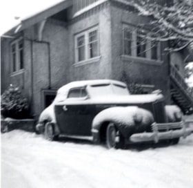
- Photograph of Dennis Krewenchuk's snow covered 1941 Packard automobile parked in the snowy driveway outside his parent's home and business, The Nelson Auto Court (also known as the Nelson Motel and Nelson Bungalow Court).
- Repository
- City of Burnaby Archives
- Date
- 1964
- Collection/Fonds
- Krewenchuk family fonds
- Physical Description
- 1 photograph : b&w ; 9 x 9 cm
- Description Level
- Item
- Record No.
- 582-005
- Access Restriction
- No restrictions
- Reproduction Restriction
- No restrictions
- Accession Number
- 2015-05
- Scope and Content
- Photograph of Dennis Krewenchuk's snow covered 1941 Packard automobile parked in the snowy driveway outside his parent's home and business, The Nelson Auto Court (also known as the Nelson Motel and Nelson Bungalow Court).
- Media Type
- Photograph
- Notes
- Title based on contents of photograph
- Date on border of photograph reads: "64"
- Geographic Access
- Dunblane Avenue
- Marlborough Avenue
- Historic Neighbourhood
- Central Park (Historic Neighbourhood)
- Planning Study Area
- Windsor Area
Images

Packard automobile
https://search.heritageburnaby.ca/link/archivedescription88414
- Repository
- City of Burnaby Archives
- Date
- 1962
- Collection/Fonds
- Krewenchuk family fonds
- Description Level
- Item
- Physical Description
- 1 photograph : b&w ; 7.5 x 10.5 cm
- Scope and Content
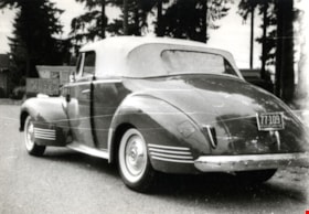
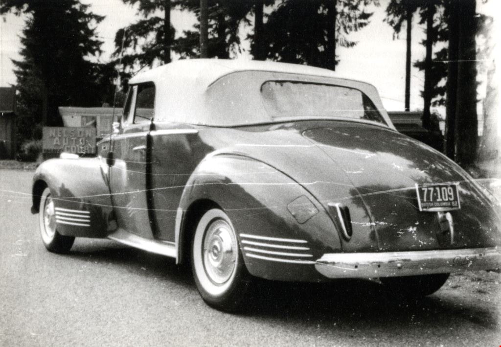
- Photograph of a 1941 Packard automobile owned by Dennis Krewenchuk from 1961 to 1964. The car is parked on the road outside Lobely Park on Dunblane Avenue. The Nelson Auto Court sign can be seen in the background. Dennis Krewenchuk's parents owned the Auto Court from 1957 to 1967 and Dennis lived t…
- Repository
- City of Burnaby Archives
- Date
- 1962
- Collection/Fonds
- Krewenchuk family fonds
- Physical Description
- 1 photograph : b&w ; 7.5 x 10.5 cm
- Description Level
- Item
- Record No.
- 582-003
- Access Restriction
- No restrictions
- Reproduction Restriction
- No restrictions
- Accession Number
- 2015-05
- Scope and Content
- Photograph of a 1941 Packard automobile owned by Dennis Krewenchuk from 1961 to 1964. The car is parked on the road outside Lobely Park on Dunblane Avenue. The Nelson Auto Court sign can be seen in the background. Dennis Krewenchuk's parents owned the Auto Court from 1957 to 1967 and Dennis lived there while atteding highschool.
- Subjects
- Transportation - Automobiles
- Media Type
- Photograph
- Notes
- Title based on contents of photograph
- Note on verso of photograph reads: "62"
- Geographic Access
- Dunblane Avenue
- Historic Neighbourhood
- Central Park (Historic Neighbourhood)
- Planning Study Area
- Windsor Area
Images
Packard automobile
https://search.heritageburnaby.ca/link/archivedescription88415
- Repository
- City of Burnaby Archives
- Date
- 1962
- Collection/Fonds
- Krewenchuk family fonds
- Description Level
- Item
- Physical Description
- 1 photograph : b&w ; 7.5 x 10.5 cm
- Scope and Content
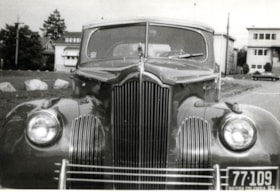
- Photograph of the front of a 1941 Packard automobile owned by Dennis Krewenchuk from 1961 to 1964. The car is parked on the road outside Lobely Park on Dunblane Avenue with buildings on Marlborough Street in the background.
- Repository
- City of Burnaby Archives
- Date
- 1962
- Collection/Fonds
- Krewenchuk family fonds
- Physical Description
- 1 photograph : b&w ; 7.5 x 10.5 cm
- Description Level
- Item
- Record No.
- 582-004
- Access Restriction
- No restrictions
- Reproduction Restriction
- No restrictions
- Accession Number
- 2015-05
- Scope and Content
- Photograph of the front of a 1941 Packard automobile owned by Dennis Krewenchuk from 1961 to 1964. The car is parked on the road outside Lobely Park on Dunblane Avenue with buildings on Marlborough Street in the background.
- Subjects
- Transportation - Automobiles
- Media Type
- Photograph
- Notes
- Title based on contents of photograph
- Note on verso of photograph reads: "62"
- Geographic Access
- Dunblane Avenue
- Marlborough Avenue
- Historic Neighbourhood
- Central Park (Historic Neighbourhood)
- Planning Study Area
- Windsor Area
Images


Patterson Family Home
https://search.heritageburnaby.ca/link/archivedescription35208
- Repository
- City of Burnaby Archives
- Date
- 1908 (date of original), copied 1986
- Collection/Fonds
- Burnaby Historical Society fonds
- Description Level
- Item
- Physical Description
- 1 photograph : b&w ; 12.7 x 17.8 cm print
- Scope and Content
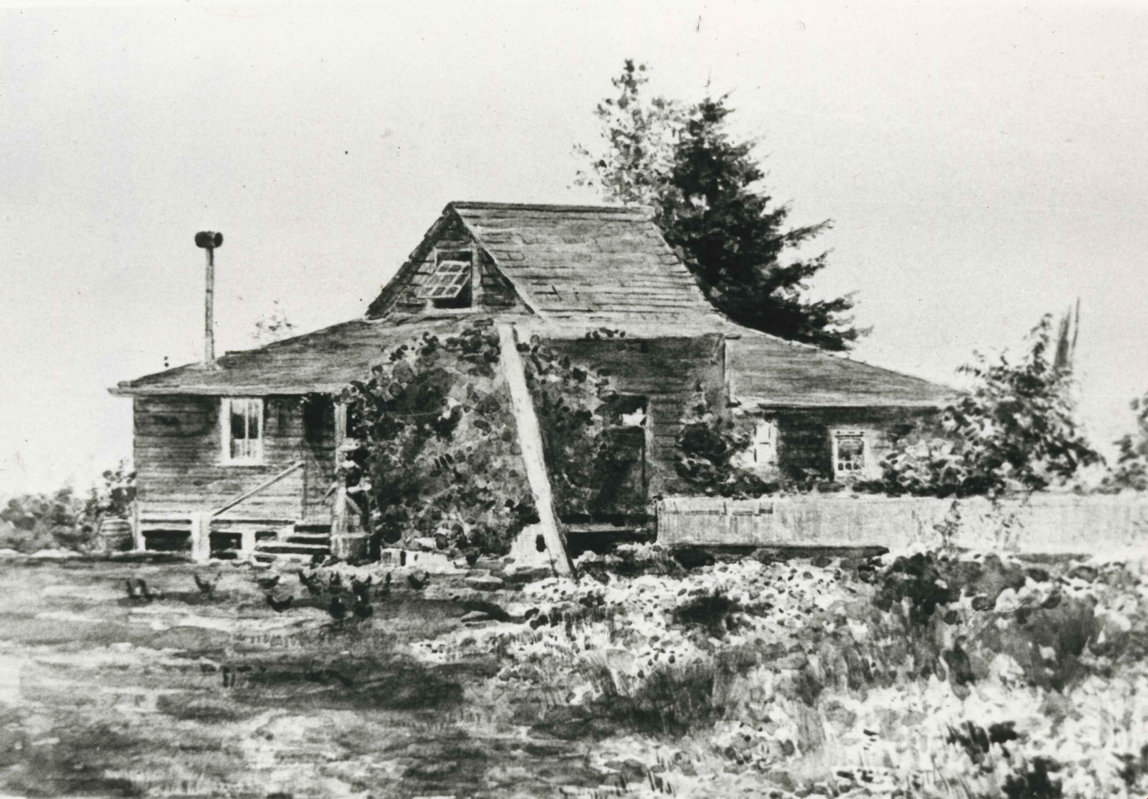
- Photograph of a 1908 watercolour of the original Patterson homestead built in 1894 on Patterson Trail, now Patterson Avenue. A woman feeding chickens can be seen by the front steps.
- Repository
- City of Burnaby Archives
- Date
- 1908 (date of original), copied 1986
- Collection/Fonds
- Burnaby Historical Society fonds
- Subseries
- Pioneer Tales subseries
- Physical Description
- 1 photograph : b&w ; 12.7 x 17.8 cm print
- Description Level
- Item
- Record No.
- 204-065
- Access Restriction
- No restrictions
- Reproduction Restriction
- No known restrictions
- Accession Number
- BHS1988-03
- Scope and Content
- Photograph of a 1908 watercolour of the original Patterson homestead built in 1894 on Patterson Trail, now Patterson Avenue. A woman feeding chickens can be seen by the front steps.
- Subjects
- Arts - Paintings
- Media Type
- Photograph
- Notes
- Title based on contents of photograph
- Geographic Access
- Patterson Avenue
- Historic Neighbourhood
- Central Park (Historic Neighbourhood)
Images
![Philips family in dining room at Christmas, [Jan. 1962] thumbnail](/media/hpo/_Data/_BVM_Images/2022/2022_0011_0002_001.jpg?width=280)
Philips family in dining room at Christmas
https://search.heritageburnaby.ca/link/museumdescription19083
- Repository
- Burnaby Village Museum
- Date
- [Jan. 1962]
- Collection/Fonds
- Earl and Adell Philips family fonds
- Description Level
- Item
- Physical Description
- 1 photograph : b&w ; 9 x 9 cm
- Scope and Content
- Photograph of the Philips family seated around a table in their dining room of their house located at 5877 Barker Avenue, Burnaby. People are identified from left to right: Shannon McKeemen and Ann McKeemen, Bob Paterson, Earl Philips, Adell Philips, Lorayne Philips, Cory Philips, Lea Philips, Ju…
- Repository
- Burnaby Village Museum
- Collection/Fonds
- Earl and Adell Philips family fonds
- Description Level
- Item
- Physical Description
- 1 photograph : b&w ; 9 x 9 cm
- Scope and Content
- Photograph of the Philips family seated around a table in their dining room of their house located at 5877 Barker Avenue, Burnaby. People are identified from left to right: Shannon McKeemen and Ann McKeemen, Bob Paterson, Earl Philips, Adell Philips, Lorayne Philips, Cory Philips, Lea Philips, Judith Philips. Photograph was taken during Christmas, everyone is wearing a tissue paper hat and the table cloth has a pointsettia design.
- Names
- Philips, Adell Greenwood
- Philips, Judith
- Philips, Lea
- Philips, Lorayne
- Philips, Earl Gene
- Philips, Cory
- McKeeman, Ann
- McKeeman, Shannon
- Paterson, Bob
- Geographic Access
- Barker Avenue
- Street Address
- 5877 Barker Avenue
- Accession Code
- BV022.11.2
- Access Restriction
- No restrictions
- Reproduction Restriction
- No known restrictions
- Date
- [Jan. 1962]
- Media Type
- Photograph
- Historic Neighbourhood
- Central Park (Historic Neighbourhood)
- Notes
- Title based on contents of photograph
- Stamp along right edge of photo includes print date which reads: "JAN. 62"
- Note in pencil on verso of photograph reads: "Barker Ave. / Christmas 1961"
Images
![Philips family in dining room at Christmas, [Jan. 1962] thumbnail](/media/hpo/_Data/_BVM_Images/2022/2022_0011_0002_001.jpg)
![Phillips-Hoyt Lumber Company, [1905] (date of original), copied 1992 thumbnail](/media/hpo/_Data/_Archives_Images/_Unrestricted/315/315-070.jpg?width=280)
Phillips-Hoyt Lumber Company
https://search.heritageburnaby.ca/link/archivedescription36715
- Repository
- City of Burnaby Archives
- Date
- [1905] (date of original), copied 1992
- Collection/Fonds
- Burnaby Historical Society fonds
- Description Level
- Item
- Physical Description
- 1 photograph : b&w ; 8.3 x 12.0 cm print
- Scope and Content
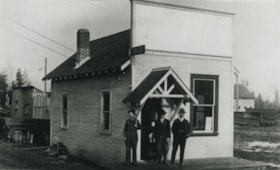
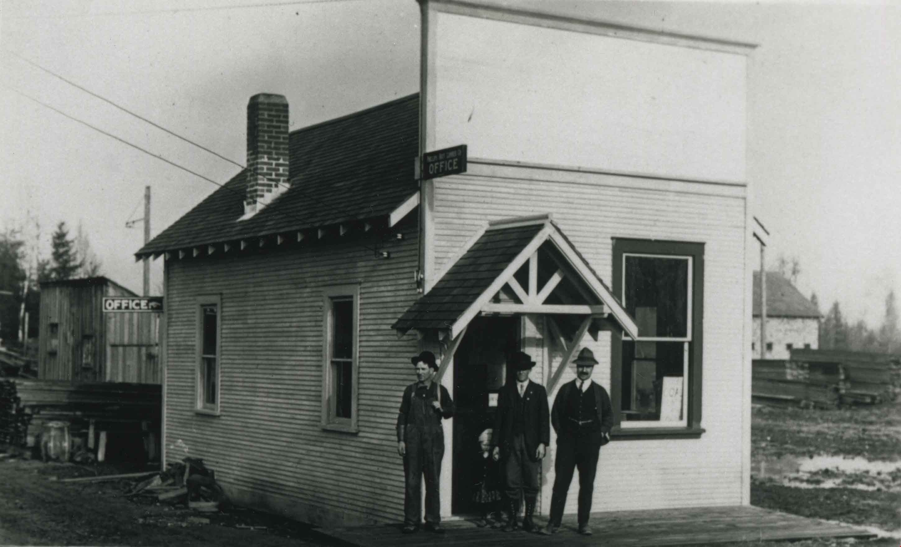
- Photograph of the exterior of the building housing the Phillips, Hoyt Lumber Co. office with three men standing outside. The building was located at 2730 McKay Avenue (old street numbering system) and the site is now a part of the Burnaby Public Library site.
- Repository
- City of Burnaby Archives
- Date
- [1905] (date of original), copied 1992
- Collection/Fonds
- Burnaby Historical Society fonds
- Subseries
- Burnaby Centennial Anthology subseries
- Physical Description
- 1 photograph : b&w ; 8.3 x 12.0 cm print
- Description Level
- Item
- Record No.
- 315-070
- Access Restriction
- No restrictions
- Reproduction Restriction
- No known restrictions
- Accession Number
- BHS1994-04
- Scope and Content
- Photograph of the exterior of the building housing the Phillips, Hoyt Lumber Co. office with three men standing outside. The building was located at 2730 McKay Avenue (old street numbering system) and the site is now a part of the Burnaby Public Library site.
- Subjects
- Buildings - Commercial
- Media Type
- Photograph
- Notes
- Title based on contents of photograph
- Geographic Access
- Willingdon Avenue
- Street Address
- 6100 Willingdon Avenue
- Historic Neighbourhood
- Central Park (Historic Neighbourhood)
- Planning Study Area
- Maywood Area
Images
![Phillips-Hoyt Lumber Company, [1905] (date of original), copied 1992 thumbnail](/media/hpo/_Data/_Archives_Images/_Unrestricted/315/315-070.jpg)
Phillips-Hoyt Lumber Company
https://search.heritageburnaby.ca/link/archivedescription36766
- Repository
- City of Burnaby Archives
- Date
- 1905 (date of original), copied 1992
- Collection/Fonds
- Burnaby Historical Society fonds
- Description Level
- Item
- Physical Description
- 1 photograph : b&w ; 7.9 x 12.5 cm print
- Scope and Content
- Photograph of the exterior of the Phillips, Hoyt Lumber Co. on McKay Avenue with three men standing in front. This property is now part of the Burnaby Public Library site.
- Repository
- City of Burnaby Archives
- Date
- 1905 (date of original), copied 1992
- Collection/Fonds
- Burnaby Historical Society fonds
- Subseries
- Burnaby Centennial Anthology subseries
- Physical Description
- 1 photograph : b&w ; 7.9 x 12.5 cm print
- Description Level
- Item
- Record No.
- 315-121
- Access Restriction
- No restrictions
- Reproduction Restriction
- No known restrictions
- Accession Number
- BHS1994-04
- Scope and Content
- Photograph of the exterior of the Phillips, Hoyt Lumber Co. on McKay Avenue with three men standing in front. This property is now part of the Burnaby Public Library site.
- Subjects
- Buildings - Commercial
- Media Type
- Photograph
- Notes
- Title based on contents of photograph
- Geographic Access
- McKay Avenue
- Willingdon Avenue
- Street Address
- 6100 Willingdon Avenue
- Historic Neighbourhood
- Central Park (Historic Neighbourhood)
- Planning Study Area
- Maywood Area
Images
Phillips-Hoyt Lumber Company after snowfall
https://search.heritageburnaby.ca/link/archivedescription36769
- Repository
- City of Burnaby Archives
- Date
- 1905 (date of original), copied 1992
- Collection/Fonds
- Burnaby Historical Society fonds
- Description Level
- Item
- Physical Description
- 1 photograph : b&w ; 12.6 x 8.7 cm print
- Scope and Content
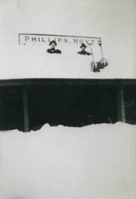
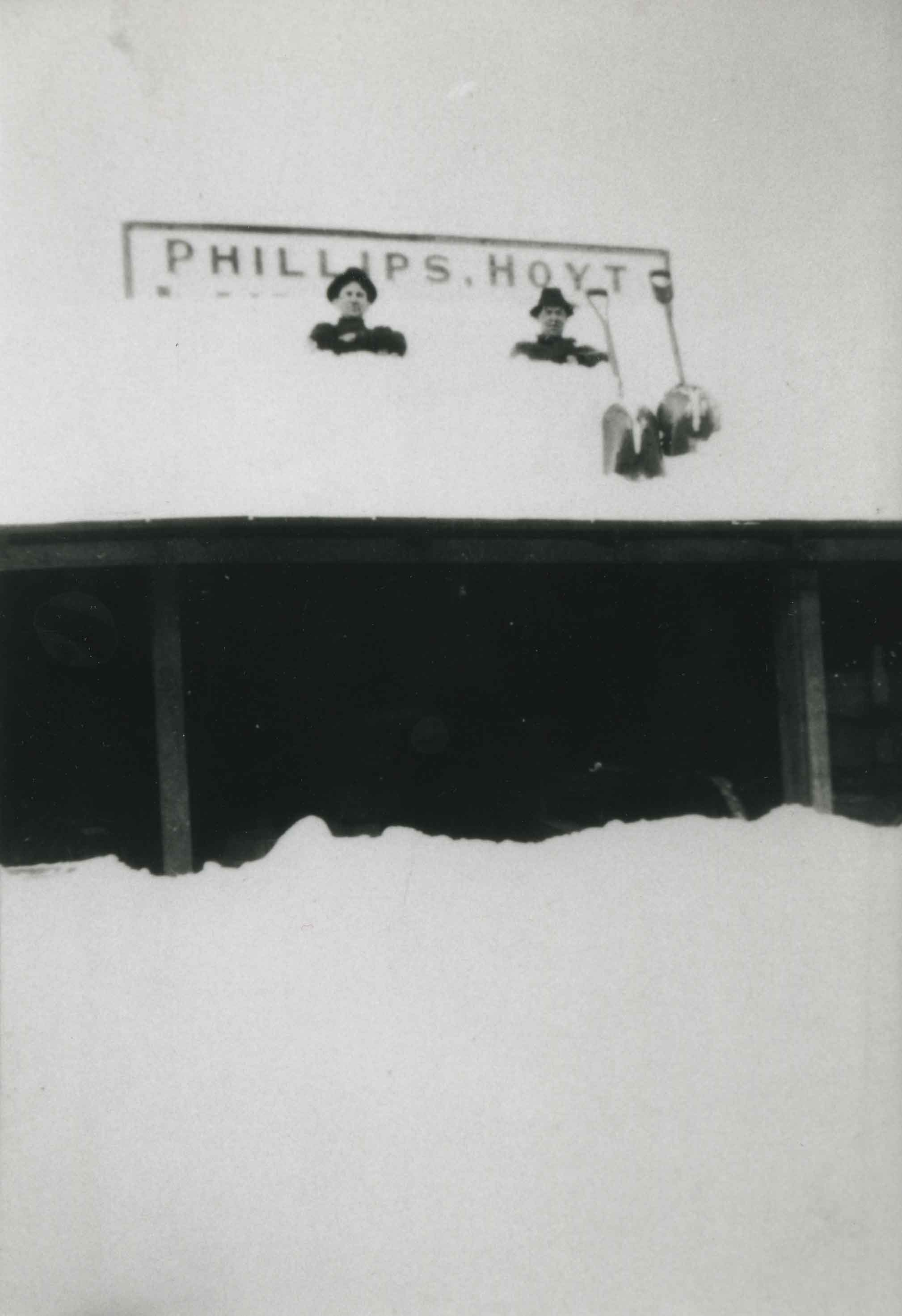
- Photograph of a building of the Phillips, Hoyt Lumber Co. after a snowfall. Two men are on the roof of the building with shovels.
- Repository
- City of Burnaby Archives
- Date
- 1905 (date of original), copied 1992
- Collection/Fonds
- Burnaby Historical Society fonds
- Subseries
- Burnaby Centennial Anthology subseries
- Physical Description
- 1 photograph : b&w ; 12.6 x 8.7 cm print
- Description Level
- Item
- Record No.
- 315-124
- Access Restriction
- No restrictions
- Reproduction Restriction
- No known restrictions
- Accession Number
- BHS1994-04
- Scope and Content
- Photograph of a building of the Phillips, Hoyt Lumber Co. after a snowfall. Two men are on the roof of the building with shovels.
- Subjects
- Buildings - Commercial
- Media Type
- Photograph
- Notes
- Title based on contents of photograph
- Geographic Access
- McKay Avenue
- Willingdon Avenue
- Street Address
- 6100 Willingdon Avenue
- Historic Neighbourhood
- Central Park (Historic Neighbourhood)
- Planning Study Area
- Maywood Area
Images
![Sambo's Pancake House, [196-] thumbnail](/media/hpo/_Data/_Archives_Images/_Unrestricted/126/201-001.jpg?width=280)
Sambo's Pancake House
https://search.heritageburnaby.ca/link/archivedescription35138
- Repository
- City of Burnaby Archives
- Date
- [196-]
- Collection/Fonds
- Burnaby Historical Society fonds
- Description Level
- Item
- Physical Description
- 1 photograph : col. postcard ; 8.9 x 14.0 cm
- Scope and Content
- Photographic postcard of the exterior and parking lot of Sambo's Pancake House, Kingsway. Printed on the top of the front of the postcard is "Sambo's Pancake House," and a sign on the building read's "Sambo's." Written on the back of the postcard: "Please surrender this card for 10% discount on you…
- Repository
- City of Burnaby Archives
- Date
- [196-]
- Collection/Fonds
- Burnaby Historical Society fonds
- Subseries
- Photographs subseries
- Physical Description
- 1 photograph : col. postcard ; 8.9 x 14.0 cm
- Description Level
- Item
- Record No.
- 201-001
- Access Restriction
- No restrictions
- Reproduction Restriction
- Reproduce for fair dealing purposes only
- Accession Number
- BHS1987-10
- Scope and Content
- Photographic postcard of the exterior and parking lot of Sambo's Pancake House, Kingsway. Printed on the top of the front of the postcard is "Sambo's Pancake House," and a sign on the building read's "Sambo's." Written on the back of the postcard: "Please surrender this card for 10% discount on your next visit to Sambo's, 5550 Kingsway, Burnaby. Offer good until Feb. 28th, 1969. Your host Sambo's."
- Subjects
- Geographic Features - Automobile Parking Lots
- Documentary Artifacts - Postcards
- Buildings - Commercial - Restaurants
- Names
- Sambo's Pancake House
- Media Type
- Photograph
- Notes
- Title based on contents of photograph
- Geographic Access
- Kingsway
- Street Address
- 5550 Kingsway
- Historic Neighbourhood
- Central Park (Historic Neighbourhood)
- Planning Study Area
- Windsor Area
Images
![Sambo's Pancake House, [196-] thumbnail](/media/hpo/_Data/_Archives_Images/_Unrestricted/126/201-001.jpg)
![Sanderson family home, [between 1950 and 1969] thumbnail](/media/hpo/_Data/_Archives_Images/_Unrestricted/513/521-022.jpg?width=280)
Sanderson family home
https://search.heritageburnaby.ca/link/archivedescription65790
- Repository
- City of Burnaby Archives
- Date
- [between 1950 and 1969]
- Collection/Fonds
- Field family fonds
- Description Level
- Item
- Physical Description
- 1 photograph (tiff) ; 600 ppi
- Scope and Content
- Photograph of the Sanderson family home (believed to be located at 3812/5457 Inman Avenue, one block north of Central Park). A larger house which still stands on this property replaced this house in 1921.
- Repository
- City of Burnaby Archives
- Date
- [between 1950 and 1969]
- Collection/Fonds
- Field family fonds
- Physical Description
- 1 photograph (tiff) ; 600 ppi
- Material Details
- Item is a scan of a b&w photograph
- Description Level
- Item
- Record No.
- 521-022
- Access Restriction
- No restrictions
- Reproduction Restriction
- Reproduce for fair dealing purposes only
- Accession Number
- 2010-14
- Scope and Content
- Photograph of the Sanderson family home (believed to be located at 3812/5457 Inman Avenue, one block north of Central Park). A larger house which still stands on this property replaced this house in 1921.
- Subjects
- Buildings - Residential - Houses
- Media Type
- Photograph
- Notes
- Title based on contents of photograph
- Geographic Access
- Inman Avenue
- Historic Neighbourhood
- Central Park (Historic Neighbourhood)
- Planning Study Area
- Maywood Area
Images
![Sanderson family home, [between 1950 and 1969] thumbnail](/media/hpo/_Data/_Archives_Images/_Unrestricted/513/521-022.jpg)
![Smith family home, [1960] (date of original), copied 1986 thumbnail](/media/hpo/_Data/_Archives_Images/_Unrestricted/204/204-310.jpg?width=280)
Smith family home
https://search.heritageburnaby.ca/link/archivedescription35452
- Repository
- City of Burnaby Archives
- Date
- [1960] (date of original), copied 1986
- Collection/Fonds
- Burnaby Historical Society fonds
- Description Level
- Item
- Physical Description
- 1 photograph : b&w ; 12.7 x 17.8 cm print
- Scope and Content
- Photograph of the Smith family home at 6186 Royal Oak Road. Although this photograph was taken in the 1960s, this was one of the first houses built on Royal Oak, in 1907. This was the home of James Smith and his wife, Agnes Smith (nee Taylor). They had four children: Grace Smith (later Grace Pletc…
- Repository
- City of Burnaby Archives
- Date
- [1960] (date of original), copied 1986
- Collection/Fonds
- Burnaby Historical Society fonds
- Subseries
- Pioneer Tales subseries
- Physical Description
- 1 photograph : b&w ; 12.7 x 17.8 cm print
- Description Level
- Item
- Record No.
- 204-310
- Access Restriction
- No restrictions
- Reproduction Restriction
- Reproduce for fair dealing purposes only
- Accession Number
- BHS1988-03
- Scope and Content
- Photograph of the Smith family home at 6186 Royal Oak Road. Although this photograph was taken in the 1960s, this was one of the first houses built on Royal Oak, in 1907. This was the home of James Smith and his wife, Agnes Smith (nee Taylor). They had four children: Grace Smith (later Grace Pletcher), Bob Smith, Warden Smith, and Ada Smith. It was a BC Mill Timber and Trading Co. prefabricated house originally built in BC and shipped to this site.
- Subjects
- Buildings - Residential - Houses
- Media Type
- Photograph
- Notes
- Title based on contents of photograph
- Geographic Access
- Royal Oak Avenue
- Street Address
- 6186 Royal Oak Avenue
- Historic Neighbourhood
- Central Park (Historic Neighbourhood)
- Planning Study Area
- Windsor Area
Images
![Smith family home, [1960] (date of original), copied 1986 thumbnail](/media/hpo/_Data/_Archives_Images/_Unrestricted/204/204-310.jpg)

Survey and Subdivision plans in New Westminster District Group 1 – Burnaby
https://search.heritageburnaby.ca/link/museumdescription6971
- Repository
- Burnaby Village Museum
- Date
- 1904-1908
- Collection/Fonds
- Burnaby Village Museum Map collection
- Description Level
- File
- Physical Description
- 7 plans : blueprint ink on paper mounted on 2 sides of cardboard 76 cm x 101.5 cm
- Scope and Content
- Item consists of a large board of four New Westminster District Gp 1 -subdivision plans mounted on one side and three New Westminster District Gp 1 - subdivision plans mounted on the other side. Side A: 1. Blueprint "Plan / of Subdivision of / Lot 28A / in Subdivision of / Lot 97, Group 1 / Ne…
- Repository
- Burnaby Village Museum
- Collection/Fonds
- Burnaby Village Museum Map collection
- Description Level
- File
- Physical Description
- 7 plans : blueprint ink on paper mounted on 2 sides of cardboard 76 cm x 101.5 cm
- Material Details
- Scales [between1:120 and 1:3960]
- Index number on edge of board reads: "3"
- Scope and Content
- Item consists of a large board of four New Westminster District Gp 1 -subdivision plans mounted on one side and three New Westminster District Gp 1 - subdivision plans mounted on the other side. Side A: 1. Blueprint "Plan / of Subdivision of / Lot 28A / in Subdivision of / Lot 97, Group 1 / New Westminster District". The B.C.E.R. is identified running through the subdivision of XXVIIIA (Lot 28A). Plan is dated "Sept. 21st, 08" (Geographic location: Burnaby) 2. Blueprint "Measurements / of Discharge / in Ditches / Lots 155A, G.One" / "Scale, Twentieths. / 17/12/04" (Geographic location: Burnaby) 3. Blueprint "Plan / of Subdivision / of a portion of / Lot 95 / Group One / New Westminster District" B.C. Electric Railway runs through the top of the plan. The plan is dated May 23, 1906. (Geographic location: Burnaby) 4. Blueprint " Profile / on Water Surface / in / Holland Road Ditch / Woollard's Ditch / Dec. 3rd 1904 / Scales Hor. 200'=1" / Vert. 10'=1"" (Geographic location: Burnaby) Side B: 1. Blueprint " "Sunnyside Park" / plan of Subdivision / of / the East Half / of / Lot 39, GR.One, / New Westminster District / Scale 100'=1" (Geographic location: Burnaby) 2. Blueprint " "Sunnyside Park"/ plan of Subdivi..n / of / Lot 39, Gr.1. / New Westminster District" Index in upper left corner of plan shows location of Lot 39 in relation to Central Park and surrounding Lots. (Geographic location: Burnaby) 3. Blueprint "Plan / of Subdivision / of / Lot 163 and 165 / Group One / New Westminster District / Scale 5 chs=1 in." Streets within subdivision plan are identified as; North Arm Road, Ingram Street, Blair Street, Kennedy Street, Murray Street, Wiggins Road, Byrne Road, South Road along with North Arm Fraser River and B.C. Electric Railway. (Geographic location: Burnaby)
- Geographic Access
- Central Park
- Accession Code
- HV977.93.3
- Access Restriction
- No restrictions
- Reproduction Restriction
- No known restrictions
- Date
- 1904-1908
- Media Type
- Cartographic Material
- Historic Neighbourhood
- Central Park (Historic Neighbourhood)
- Scan Resolution
- 300
- Scale
- 72
- Notes
- Title based on contents of file
- Scale is measured in chains and feet. (One chain equals 792 inches)
- The term "Lot" can also refer to a "District Lot”
Images


![Survey and Subdivision plans in New Westminster District Group 1 – Burnaby, [1905-1917] thumbnail](/media/hpo/_Data/_BVM_Cartographic_Material/1977/1977_0093_0022a_001.jpg?width=280)
Survey and Subdivision plans in New Westminster District Group 1 – Burnaby
https://search.heritageburnaby.ca/link/museumdescription6991
- Repository
- Burnaby Village Museum
- Date
- [1905-1917]
- Collection/Fonds
- Burnaby Village Museum Map collection
- Description Level
- File
- Physical Description
- 12 plans : 6 black ink on paper + 2 black & col. ink on paper + 4 graphite on paper
- Scope and Content
- Item consists of a large board of six New Westminster District subdivision plans mounted on one side and six New Westminster District subdivision plans mounted on the other side. Side A: 1. Plan drawn in graphite with markings in black ink "Surveyed for Mr. W. Wilson / Paterson Stat. B.C.E.R." . …
- Repository
- Burnaby Village Museum
- Collection/Fonds
- Burnaby Village Museum Map collection
- Description Level
- File
- Physical Description
- 12 plans : 6 black ink on paper + 2 black & col. ink on paper + 4 graphite on paper
- Material Details
- Scales [between 1:360 and 1:3168]
- Index number on edge of board reads: "22"
- Scope and Content
- Item consists of a large board of six New Westminster District subdivision plans mounted on one side and six New Westminster District subdivision plans mounted on the other side. Side A: 1. Plan drawn in graphite with markings in black ink "Surveyed for Mr. W. Wilson / Paterson Stat. B.C.E.R." . Plan includes subdivision of lots situated between B.C.E. Railway and Vancouver Road (Kingsway). (Geographic location: Burnaby) 2. Subdivision plan (no title) drawn in black ink with annotations in graphite. Plan covers District Lots 2, 4 and 6, west of North Road. Plan is stamped: "Albert J. Hill, Civil Engineer / and / Provincial Land Surveyor, / New Westminster, / B.C. (Geographic location: Burnaby) 3. Plan of "Portion of Municipality" with intials "RB" [sic] (handwritten in blue crayon). Plan covers the area north east of the City of New Westminster including District Lots 11, 13, 14, 12, 1 and 2. Plan is stamped: "Albert J. Hill, Civil Engineer / and / Provincial Land Surveyor, / New Westminster, / B.C. (Geographic location: Burnaby) 4."Plan / of Subdivision of / N.W.1/4 Lot 175 / Group 1 New West. Dist. / B.C. / Scale 4 chs = 1 in. " Plan is stamped: "Albert J. Hill, Civil Engineer / and / Provincial Land Surveyor, / New Westminster, / B.C. and initialed : "RB" [sic] (in blue pencil crayon) (Geographic location: Burnaby) 5. "Subdivision / of a Portion of / Lot 15 Group 1 / New Westminster Dist. / Scale 4 chs = 1 in". Plan provides numbered sudivisions - Lots 1 to 15 of District Lot 15 in red ink. (Geographic location: Burnaby) 6. Plan of "Central Park & / Vicinity" Plan includes subdivisions of District Lot 153 east of Central Park District Lot 151 and subdivision of District Lot 36 and 49 west of Boundary Road (Vancouver). Plan is stamped: "Albert J. Hill, Civil Engineer / and / Provincial Land Surveyor, / New Westminster, / B.C. and initialed : "RB" [sic] (in blue pencil crayon). (Geographic location: Burnaby) Side B: 1. Subdivision plan (no title) drawn in black ink. Plan identifies lots between Vancouver Road (Yale Road is crossed out and replaced with Vancouver Road) and B.C.E. Railway. "Scale 2 chs = 1 in" (Geographic location: Burnaby) 2. Plan of "Subdivision Lot 1 / Lot 69 Gr. 1 / Scale 30' = 1 " " Plan identifies Boundary Road, Still Creek and a Road Allowance between District Lot 118 and District Lot 69. Plan was "Surveyed for Burnaby Mun. Council / March 11th 1908 / G.K.B." (Geographic location: Burnaby) 3. Plan drawn in black ink (no title) showing a subdivision in Lot 25 with names "Newcomb", "Debeck" and "Armstrong" along with roads identified as Third Street, Cumberland Street, Armstrong Street and Cariboo [sic] Street and including Lots 27, 11 and 13.Plan is stamped: "Albert J. Hill, Civil Engineer / and / Provincial Land Surveyor, / New Westminster, / B.C. and initialed : "RB" [sic] (in blue pencil crayon). (Geographic location: Burnaby) 4. Handrawn subdivision plan in graphite titled: "Lot 13, Gr.1" with intials "RB" [sic] (handwritten in blue crayon). Plan is bordered by Armstrong Street (Lot 11, G.1), Cumberland St. (Lot 25, G.1) and Tenth Avenue (City Boundary). The plan is singed by "Albert J. Hill / P.L.S." and one of the subdivided lots is identified with the name: "W. Karrymann". (Geographic location: Burnaby) 5. Handrawn sketch in graphite titled: "Lot 88, Gr.1" with intials "RB" [sic] (handwritten in blue crayon). Plan appears to be a draft of a subdivision plan of a portion of District Lot 88 along Cumberland Road. The plan is signed: "16/7/17 _W.F. Draper [sic] / B.C.L.S." (Geographic location: Burnaby) 6. "Plan / of Subdivision / of Blocks 61, 62 and 2 / Lot 30 / Group 1 / N.W. Dist. / Scale 1ch = 1 in". Plan is intialed by: "PB" with a note: "Also see board 2 / for duplicate" (handwritten in blue crayon). (Geographic location: Burnaby)
- Creator
- Hill, Albert James
- Geographic Access
- Boundary Road
- Kingsway
- Cumberland Street
- Accession Code
- HV977.93.22
- Access Restriction
- No restrictions
- Reproduction Restriction
- No known restrictions
- Date
- [1905-1917]
- Media Type
- Cartographic Material
- Historic Neighbourhood
- Central Park (Historic Neighbourhood)
- Scan Resolution
- 300
- Scale
- 100
- Notes
- Title based on contents of file
- Scale is measured in chains and feet. (One chain equals 792 inches)
- The term "Lot" can also refer to a "District Lot”
- Some plans are stamped: "Albert J. Hill, Civil Engineer / and / Provincial Land Surveyor, / New Westminster, / B.C." and intialed: "RB" [sic]
Images
![Survey and Subdivision plans in New Westminster District Group 1 – Burnaby, [1905-1917] thumbnail](/media/hpo/_Data/_BVM_Cartographic_Material/1977/1977_0093_0022a_001.jpg)
