
Central Park Neighbourhood
https://search.heritageburnaby.ca/link/landmark688
- Repository
- Burnaby Heritage Planning
- Associated Dates
- 1925-1954
- Heritage Value
- Although still largely a rural area during the 1920s, subdivisions began appearing in the Central Park neighbourhood at this time. Development was slowed by the Great Depression of the 1930s but the influx of commercial buildings and new housing initiatives in the post-war boom led to a period of rapid growth especially in the Garden Village subdivision which was undertaken in 1953 with the plan to build 500 modern homes in the 140-acre site. Despite the closure of the interurban line in 1953, the neighbourhood remained an active commercial and residential centre.
- Historic Neighbourhood
- Central Park (Historic Neighbourhood)
- Planning Study Area
- Maywood Area
Images


Central Park Neighbourhood
https://search.heritageburnaby.ca/link/landmark751
- Repository
- Burnaby Heritage Planning
- Associated Dates
- 1905-1924
- Heritage Value
- In 1906, Maxwell Smith, President of the Central Park Farmer's Institute gave a speech in which he commented on the growth of this district and its ideal location during the boom years after 1905. He said: "Central Park is destined to become the epicentre of a great commercial metropolis, when Vancouver and New Westminster will have both expanded and prospered until they meet and fill up the intervening distances with residences of a new city, greater than few can now imagine, even in their wildest flights of fancy...we are proud of the two cities that lie on either side of us but they are, but mere hamlets compared with the great city that is to be on this peninsula. The time is coming when there will be one vast city, one commercial metropolis, and Central Park will be the heart of it."
- Historic Neighbourhood
- Central Park (Historic Neighbourhood)
- Planning Study Area
- Maywood Area
Images


Garden Village Neighbourhood
https://search.heritageburnaby.ca/link/landmark800
- Repository
- Burnaby Heritage Planning
- Associated Dates
- 1955-2008
- Heritage Value
- Bounded by Moscrop Street to the north, Kingsway and Grange to the south, Willingdon to the east and Boundary Road to the west, the Garden Village Neighbourhood is characterised as a primarily residential area that is well-served due to its proximity to commercial, park and business centres. The north-east corner of the neighbourhood is a typical 1950s subdivision of mostly single family homes located on an irregular street pattern, while the remaining areas saw some transition to multi-family housing types throughout the 1970s and up to the current time.
- Historic Neighbourhood
- Central Park (Historic Neighbourhood)
- Planning Study Area
- Garden Village Area
Images


Maywood Neighbourhood
https://search.heritageburnaby.ca/link/landmark801
- Repository
- Burnaby Heritage Planning
- Associated Dates
- 1955-2008
- Heritage Value
- Burnaby's Maywood Neighbourhood consists of the Metrotown Town Centre - one of four Town Centres in the City. Metrotown is one of the region's most developed and fastest growing centres. It is served by the first SkyTrain line developed in the mid-1980s and anchored by B.C.'s largest shopping and entertainment complex. As an older centre that has progressively added new developments over the years, Metrotown offers a range of housing types and tenures from three-storey walk-up apartments to modern residential towers.
- Historic Neighbourhood
- Central Park (Historic Neighbourhood)
- Planning Study Area
- Maywood Area
Images


Marlborough Neighbourhood
https://search.heritageburnaby.ca/link/landmark802
- Repository
- Burnaby Heritage Planning
- Associated Dates
- 1955-2008
- Heritage Value
- The Marlborough Neighbourhood is another residential area that was witness to rapid growth and subdivision during the 1950s and 1960s, creating primarily single-family housing stock. In the 1970s and 1980s, as the commercial district around Kingsway grew, so too did higher density housing projects such as townhomes and condominiums.
- Historic Neighbourhood
- Central Park (Historic Neighbourhood)
- Planning Study Area
- Marlborough Area
Images


Oakalla Neighbourhood
https://search.heritageburnaby.ca/link/landmark804
- Repository
- Burnaby Heritage Planning
- Associated Dates
- 1955-2008
- Heritage Value
- The phasing out and demolition of the Oakalla Prison farm allowed for the planned development of the Oakalla Neighbourhood in the 1980s. By 1991, the City of Burnaby had adopted the Oakalla Development Plan which called for the transfer of land to the Deer Lake Park reserve as well as the creation of a new residential area consisting of multi-family housing types.
- Historic Neighbourhood
- Central Park (Historic Neighbourhood)
- Planning Study Area
- Oakalla Area
Images

![Fern Brown, [between 1901 and 1920] thumbnail](/media/hpo/_Data/_Archives_Images/_Unrestricted/205/228-006.jpg?width=280)
Fern Brown
https://search.heritageburnaby.ca/link/archivedescription36145
- Repository
- City of Burnaby Archives
- Date
- [between 1901 and 1920]
- Collection/Fonds
- Burnaby Historical Society fonds
- Description Level
- Item
- Physical Description
- 1 photograph : sepia ; 7.5 x 10 cm + 1 p.
- Scope and Content
- Photograph of Fern Brown (nee Ablitt) sitting on the grass of her parent's property at the northeast corner of Kingsway and Nelson Avenue. She has a doll in a baby carriage with her and ribbons in her hair. The Hutton grocery store can be seen in the distance.
- Repository
- City of Burnaby Archives
- Date
- [between 1901 and 1920]
- Collection/Fonds
- Burnaby Historical Society fonds
- Physical Description
- 1 photograph : sepia ; 7.5 x 10 cm + 1 p.
- Description Level
- Item
- Record No.
- 228-006
- Access Restriction
- No restrictions
- Reproduction Restriction
- No known restrictions
- Accession Number
- BHS1989-22
- Scope and Content
- Photograph of Fern Brown (nee Ablitt) sitting on the grass of her parent's property at the northeast corner of Kingsway and Nelson Avenue. She has a doll in a baby carriage with her and ribbons in her hair. The Hutton grocery store can be seen in the distance.
- Subjects
- Toys - Dolls
- Names
- Brown, Fern
- Media Type
- Photograph
- Notes
- Title based on contents of photograph
- Page attached to verso of photograph gives a short history of Fern Brown
- Geographic Access
- Kingsway
- Nelson Avenue
- Historic Neighbourhood
- Central Park (Historic Neighbourhood)
- Planning Study Area
- Marlborough Area
Images
![Fern Brown, [between 1901 and 1920] thumbnail](/media/hpo/_Data/_Archives_Images/_Unrestricted/205/228-006.jpg)
![Minnie Coe and Evelyn Condio, [between 1910 and 1929] thumbnail](/media/hpo/_Data/_BVM_Images/2000/200100010347.jpg?width=280)
Minnie Coe and Evelyn Condio
https://search.heritageburnaby.ca/link/museumdescription1643
- Repository
- Burnaby Village Museum
- Date
- [between 1910 and 1929]
- Collection/Fonds
- Burnaby Village Museum Photograph collection
- Description Level
- Item
- Physical Description
- 1 photograph : sepia ; 14 x 8 cm
- Scope and Content
- Photograph of cousins Mignon (Minnie) Coe and Evelyn Condio standing together in front of the arbour at the Coe family residence at 2684 Fern Avenue (renumbered in the 6300 block). Mignon Coe (later Uter) was the daughter of Elizabeth and James Coe.
- Repository
- Burnaby Village Museum
- Collection/Fonds
- Burnaby Village Museum Photograph collection
- Description Level
- Item
- Physical Description
- 1 photograph : sepia ; 14 x 8 cm
- Scope and Content
- Photograph of cousins Mignon (Minnie) Coe and Evelyn Condio standing together in front of the arbour at the Coe family residence at 2684 Fern Avenue (renumbered in the 6300 block). Mignon Coe (later Uter) was the daughter of Elizabeth and James Coe.
- Geographic Access
- Fern Avenue
- Accession Code
- BV001.1.347
- Access Restriction
- No restrictions
- Date
- [between 1910 and 1929]
- Media Type
- Photograph
- Historic Neighbourhood
- Central Park (Historic Neighbourhood)
- Planning Study Area
- Marlborough Area
- Scan Resolution
- 600
- Scan Date
- 09-Jun-09
- Scale
- 100
- Notes
- Title based on contents of photograph
- Note in pencil on verso of photograph reads: "Minnie Coe + Evelyn Condio cousin"
Images
![Minnie Coe and Evelyn Condio, [between 1910 and 1929] thumbnail](/media/hpo/_Data/_BVM_Images/2000/200100010347.jpg)

Interview with W.H. O'Brien July / August 1975 - Track 1
https://search.heritageburnaby.ca/link/oralhistory18
- Repository
- City of Burnaby Archives
- Date Range
- 1914-1932
- Length
- 0:08:44
- Summary
- This portion of the interview pertains to W.H. "Harry" O'Brien's early childhood including the reasons why his family first moved to Burnaby, his first experiences of unemployment and what initially drew him to the Working Organization in Burnaby and their protest against evictions.
- Repository
- City of Burnaby Archives
- Summary
- This portion of the interview pertains to W.H. "Harry" O'Brien's early childhood including the reasons why his family first moved to Burnaby, his first experiences of unemployment and what initially drew him to the Working Organization in Burnaby and their protest against evictions.
- Date Range
- 1914-1932
- Photo Info
- Harry and Gertrude (Sutherland) O'Brien on their wedding day, October 12, 1940. Item no. 315-005
- Length
- 0:08:44
- Subjects
- Organizations
- Protests and Demonstrations
- Geographic Access
- Inman Avenue
- Historic Neighbourhood
- Central Park (Historic Neighbourhood)
- Interviewer
- Bradbury, Dr. Bettina
- Interview Date
- July / August 1975
- Scope and Content
- Recording is a taped interview with W.H. "Harry" O'Brien by SFU (Simon Fraser University) graduate student Bettina Bradbury. Major themes discussed are: the Army of the Common Good, the Union of the Unemployed and the Common Good Credit Union (now the South Burnaby Credit Union). To view "Narrow By" terms for each track expand this description and see "Notes".
- Biographical Notes
- W.H. “Harry” O’Brien was born in the coal mining town of Nanaimo, British Columbia on October 20, 1914. He came to Burnaby with his parents and five siblings in 1927. Harry’s mother, a school teacher, wanted her children to live closer to school in order to obtain a better education, so the O’Brien family settled at Inman Avenue, Burnaby. Harry's mother, Mary Anne Crossan, was Gilmore Avenue School's first teacher. Harry left school in June of 1929. Harry’s father worked as the caretaker at Central Park around this time and Harry helped him to clear brush, plant trees and enforce the land clearing and wood cutting permit regulations held by men who were on script. Although too young to vote by just over a week, Harry O'Brien worked as a scrutineer for the Co-operative Commonwealth Federation (CCF) during the 1935 Federal Election. On October 12, 1940 Harry O'Brien married Gertrude Sutherland at St. John the Divine in Burnaby. The Sutherland family came to Burnaby from Winnipeg in 1933 and settled at Nelson Avenue. Harry began his involvement with the Unemployment Organization in Burnaby by participating in an organised protest against the municipality for homeowner evictions brought on by unpaid taxes. The South Burnaby Union of the Unemployed organised in order to protest rules around receiving Relief. Harry became involved, eventually becoming one of the spearheads of the organization, taking over as secretary by 1936. Harry was an original member of the Army of the Common Good, helping to produce over one hundred and twenty-five tons of vegetables from its own gardens to feed Burnaby citizens suffering from the lack of resources during the Depression years. The members of the Army of the Common Good who cut wood for consumption or worked in the gardens were given credit for their work through LU (Labour Units) which they could then use to buy groceries and that at the Army's Cooperative stores, one of which was at McKay Avenue, where Harry began working as Manager of Groceries in 1937. The Credit Union movement of British Columbia was also organized by Harry O'Brien and his fellow Army of the Common Good members. W.H. "Harry" O'Brien died July 1, 1992.
- Total Tracks
- 9
- Total Length
- 1:17:56
- Interviewee Name
- O'Brien, Harry
- Interviewer Bio
- Bettina Bradbury teaches history and women's studies at York University. She is the author of Wife to Widow. Lives, Laws and Politics in Nineteenth-century Montreal. (Vancouver: University of British Columbia Press, June 2011), 520p; Working Families. Age, Gender and Daily Survival in Industrializing Montreal. (Toronto: Canadian Social History Series, McClelland and Stewart, 1993); (Republished Toronto: Oxford University Press, 1996) (3rd edition, Toronto: University of Toronto Press, 2007). These interviews were undertaken after she completed her MA at Simon Fraser University in 1975 with the support of an LIP grant.
- Collection/Fonds
- Burnaby Historical Society fonds
- Subseries
- Oral history subseries
- Transcript Available
- None
- Media Type
- Sound Recording
- Web Notes
- Interview was digitized in 2010 allowing it to be accessible on Heritage Burnaby. The digitization project was initiated by the Community Heritage Commission with support from City of Burnaby Council and the BC History Digitization Program of the Irving K. Barber Learning Centre, University of British Columbia. It was recognized by the Heritage Society of BC with an award in 2012.
Images

Audio Tracks
Track one of interview with W.H.
Track one of interview with W.H.
https://search.heritageburnaby.ca/media/hpo/_Data/_Archives_Oral_Histories/_Unrestricted/100-13-25/100-13-25_Track_1.mp3![Burnaby Girl Guides, [1914]-1969, predominant ca. 1920 (date of original), copied 2016 thumbnail](/media/hpo/_Data/_BVM_Images/2015/2015_0035_0164_folded.jpg?width=280)
Burnaby Girl Guides
https://search.heritageburnaby.ca/link/museumdescription4592
- Repository
- Burnaby Village Museum
- Date
- [1914]-1969, predominant ca. 1920 (date of original), copied 2016
- Collection/Fonds
- Burnaby Girl Guides fonds
- Description Level
- File
- Physical Description
- 1 scrapbook (textual records + 2 digital files : (pdfs) + 102 photographs : (tiffs))
- Scope and Content
- File consists of images and selected contents from a scrapbook with 38 double sided pages containing mostly photographs with some newspaper clippings, written material and emphemera including a page of badges and ribbons which reads "Enrolment & Membership Card of / Joan Bailey 1926 / 1st Burnaby" …
- Repository
- Burnaby Village Museum
- Collection/Fonds
- Burnaby Girl Guides fonds
- Description Level
- File
- Physical Description
- 1 scrapbook (textual records + 2 digital files : (pdfs) + 102 photographs : (tiffs))
- Scope and Content
- File consists of images and selected contents from a scrapbook with 38 double sided pages containing mostly photographs with some newspaper clippings, written material and emphemera including a page of badges and ribbons which reads "Enrolment & Membership Card of / Joan Bailey 1926 / 1st Burnaby" and an embroidered alphabet of the Morse Code. The third page of the scrapbook includes a four page chronology titled "History of Guiding - Burnaby / 1913 - 1960" compiled by Mrs. Dolly Weber, Mrs. J. Heaps, Miss Eileen Periton, Mrs. J. Albertson and D. Fowler. The scrapbook also includes an original letter and post-script from Lady Olave Baden-Powell to Mrs. Fowler dated November 5, 1961; a typewritten copy of: "TSOONA" / PROVINCIAL GUIDE CAMPSITE - ROSEDALE B.C." and a three page typewritten copy of "THE CAMPFIRE / Volume 1, No. 4 _ November 1935 _ Vancouver, B.C.". Many of the events documented in photographs [between 1914 and 1969] are identified on each page and read as the following: "Burnaby Brownies - Guides & Rangers" / "Early 1920" (1 photograph); "Ambulance / Display / 1st. Co."; "Girl Guide Rally - New Westminster and / Burnaby - June 16, 1923" (5 photographs); "Girl Guide Rally - New Westminster and / Burnaby - June 16, 1923" (5 photographs); "Burnaby Guides and / Brownies / June 17, 1923" (5 photographs); "April 1923" (1 photograph); "June 1923 / 2nd Burnaby Company" (1 photograph); "Burnaby May Day / 26.5.28"(2 photographs); "Sechelt 1929_ 2nd "B" Company" (2 photographs); "Leaders and Seconds / 2nd Burnaby / Grouse Mountain" (1 photograph); "Sechelt 1929 / Commandant Mrs. Peal" (1 photograph); "2nd Company / June 1930" (1 photograph); "1932 / 2nd Company at Rally / Municipal Hall Grounds" (1 photograph) ; "First Burnaby Folk Dancing team / Winners of the E.F.D. cup 1940--41-42" (1 photograph); "1st Burnaby Company / winners of Bessborough Shield / 1942 / Captain L. Crane" (1 photograph); "May 6th 1935 / Dedication of flag at Central Park" (1 photograph); "May Day Celebration / Burnaby B.C. May 6th 1935 / Stride Studios Photos" (1 photograph); "Mrs. Don Wilks / Mrs. Georgie / Runcie / Publicity Photo re- / Brownie / Training / 1958-60" (1 photograph); "Kathleen Anderson / about 1958-60?" (1 photograph); "1957 / Burnaby Camp Site / at / Wilson Creek" (1 photograph); "Work Party (1958)" (1 photograph); "Burnaby Camp Site / Spring 1958 / Cabins & Staff Houses / Dining Shelter / Cabins" (3 photographs); "Can. Girl Guide Assoc. - Provincial Leaders Conference / April 14-15/61 Civic Centre, Prince George, BC" (1 photograph) ; "June 8th, 1958 / Opening / Ceremonies / Burnaby Site / Wilson Creek / Camp Site" (4 photographs); 2 unidentified photographs [ca.1915] of a large group of Girl Guides gathered on the Pacific National Exhibition grounds (photo credit- Leonard Frank); 1 unidentified photograph of a group of Girl Guides gathered for a group portrait [ca.1914]; "Girl Guide Camp / Granthams / Landing / July 1923" (4 photographs); 4 unidentified photographs of girl guides gathered on the ship "Lady Evelyn" [ca. 1920]; "Burnaby Girl Guides" 1918; "First Burnaby Girl Guides 1920" (2 photographs on page); "2nd Co. 1923" (1 photograph) "1st Burnaby Co." [1923] (1 photograph); "Gypsy Scene - Concert / Mar 17, 1923 / Unveiling / War / Memorial / Edmonds / 1923" (3 photographs on page); "Faith Jacobson / 1961" (2 photographs); "Eve MacLean / 1961" (1 photograph); "Beverley Simkin of Montreal and Judy Robins / of the S.R.S. Royal Oak taken on the day they / sailed from Montreal for the Ranger Camp at / "Our Chalet" in Adelboden, Switzerland, May 1962" (1 photograph) and "Religion & Life Emblem / Diane Peters 11th Bby. Co. / Rev. G.W. Luetkehodeter / 1961" (2 photographs on one page).
- Names
- Girl Guides of Canada
- Accession Code
- BV015.35.164
- Access Restriction
- No restrictions
- Reproduction Restriction
- May be restricted by third party rights
- Date
- [1914]-1969, predominant ca. 1920 (date of original), copied 2016
- Media Type
- Photograph
- Textual Record
- Historic Neighbourhood
- Edmonds (Historic Neighbourhood)
- Central Park (Historic Neighbourhood)
- Planning Study Area
- Edmonds Area
- Maywood Area
- Notes
- Transcribed title
- Digital images were created of the scrapbook prior to selective retention of original records that were removed for conservation purposes
- Some textual records that were selected for retention have been described at file level under BV015.35.164: "Tsoona" Provincial Guide Campsite - Rosedale B.C." and Burnaby Girl Guides newsletter, "The Campfire" (November 1935)
- Photographs that were retained from scrapbook have been described at item level (BV015.35.221 to BV015.35.284)
- Some textual records and ephemera that were selected for retention have been described at item level (BV015.35.320, BV015.35.321, and BV015.35.334 to BV015.35.348).
Images
![Burnaby Girl Guides, [1914]-1969, predominant ca. 1920 (date of original), copied 2016 thumbnail](/media/hpo/_Data/_BVM_Images/2015/2015_0035_0164_folded.jpg)
Documents
![Longstaff family picnic, [1919 or 1920] thumbnail](/media/hpo/_Data/_Archives_Images/_Unrestricted/251/266-001.jpg?width=280)
Longstaff family picnic
https://search.heritageburnaby.ca/link/archivedescription36419
- Repository
- City of Burnaby Archives
- Date
- [1919 or 1920]
- Collection/Fonds
- Burnaby Historical Society fonds
- Description Level
- Item
- Physical Description
- 1 photograph : b&w ; 8 x 5.5 cm
- Scope and Content
- Photograph of the Longstaff family and their friends at a picnic in Central Park. Everyone is dressed mostly in white, and four of the ten are wearing hats.
- Repository
- City of Burnaby Archives
- Date
- [1919 or 1920]
- Collection/Fonds
- Burnaby Historical Society fonds
- Subseries
- Kathleen Moore family subseries
- Physical Description
- 1 photograph : b&w ; 8 x 5.5 cm
- Description Level
- Item
- Record No.
- 266-001
- Access Restriction
- No restrictions
- Reproduction Restriction
- No known restrictions
- Accession Number
- BHS1991-33
- Scope and Content
- Photograph of the Longstaff family and their friends at a picnic in Central Park. Everyone is dressed mostly in white, and four of the ten are wearing hats.
- Media Type
- Photograph
- Notes
- Title based on contents of photograph
- Geographic Access
- Central Park
- Imperial Street
- Street Address
- 3883 Imperial Street
- Historic Neighbourhood
- Central Park (Historic Neighbourhood)
- Planning Study Area
- Maywood Area
Images
![Longstaff family picnic, [1919 or 1920] thumbnail](/media/hpo/_Data/_Archives_Images/_Unrestricted/251/266-001.jpg)
Kingsway
https://search.heritageburnaby.ca/link/archivedescription34510
- Repository
- City of Burnaby Archives
- Date
- 1920
- Collection/Fonds
- Burnaby Historical Society fonds
- Description Level
- Item
- Physical Description
- 1 photograph : sepia ; 12.6 x 17.7 cm
- Scope and Content
- Photograph of Kingsway looking east at Boundary Road. A sign on the right reads, "Burnaby / Vehicles must slow down at all schools and intersections marked thus: X." A sign on a building at the left reads, "Arctic Ice Cream." Central Park is on the right.
- Repository
- City of Burnaby Archives
- Date
- 1920
- Collection/Fonds
- Burnaby Historical Society fonds
- Subseries
- Photographs subseries
- Physical Description
- 1 photograph : sepia ; 12.6 x 17.7 cm
- Description Level
- Item
- Record No.
- 031-001
- Access Restriction
- No restrictions
- Reproduction Restriction
- No known restrictions
- Accession Number
- BHS2007-04
- Scope and Content
- Photograph of Kingsway looking east at Boundary Road. A sign on the right reads, "Burnaby / Vehicles must slow down at all schools and intersections marked thus: X." A sign on a building at the left reads, "Arctic Ice Cream." Central Park is on the right.
- Media Type
- Photograph
- Notes
- Title based on contents of photograph
- Geographic Access
- Kingsway
- Central Park
- Boundary Road
- Historic Neighbourhood
- Central Park (Historic Neighbourhood)
- Planning Study Area
- Garden Village Area
- Maywood Area
Images

Kingsway
https://search.heritageburnaby.ca/link/archivedescription34511
- Repository
- City of Burnaby Archives
- Date
- 1920
- Collection/Fonds
- Burnaby Historical Society fonds
- Description Level
- Item
- Physical Description
- 1 photograph : sepia ; 12.6 x 17.6 cm
- Scope and Content
- Photograph of Kingsway looking east at Boundary Road. A sign on the right reads, "Burnaby / Vehicles must slow down at all schools and intersections marked thus: X." A sign on a building at the left reads, "Arctic Ice Cream." Central Park is on the right.
- Repository
- City of Burnaby Archives
- Date
- 1920
- Collection/Fonds
- Burnaby Historical Society fonds
- Subseries
- Photographs subseries
- Physical Description
- 1 photograph : sepia ; 12.6 x 17.6 cm
- Description Level
- Item
- Record No.
- 031-002
- Access Restriction
- No restrictions
- Reproduction Restriction
- No known restrictions
- Accession Number
- BHS2007-04
- Scope and Content
- Photograph of Kingsway looking east at Boundary Road. A sign on the right reads, "Burnaby / Vehicles must slow down at all schools and intersections marked thus: X." A sign on a building at the left reads, "Arctic Ice Cream." Central Park is on the right.
- Subjects
- Geographic Features - Roads
- Advertising Medium - Signs and Signboards
- Transportation - Automobiles
- Media Type
- Photograph
- Notes
- Title based on contents of photograph
- Geographic Access
- Kingsway
- Central Park
- Boundary Road
- Historic Neighbourhood
- Central Park (Historic Neighbourhood)
- Planning Study Area
- Garden Village Area
- Maywood Area
Images

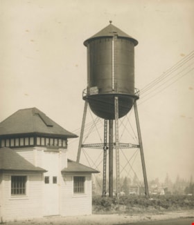
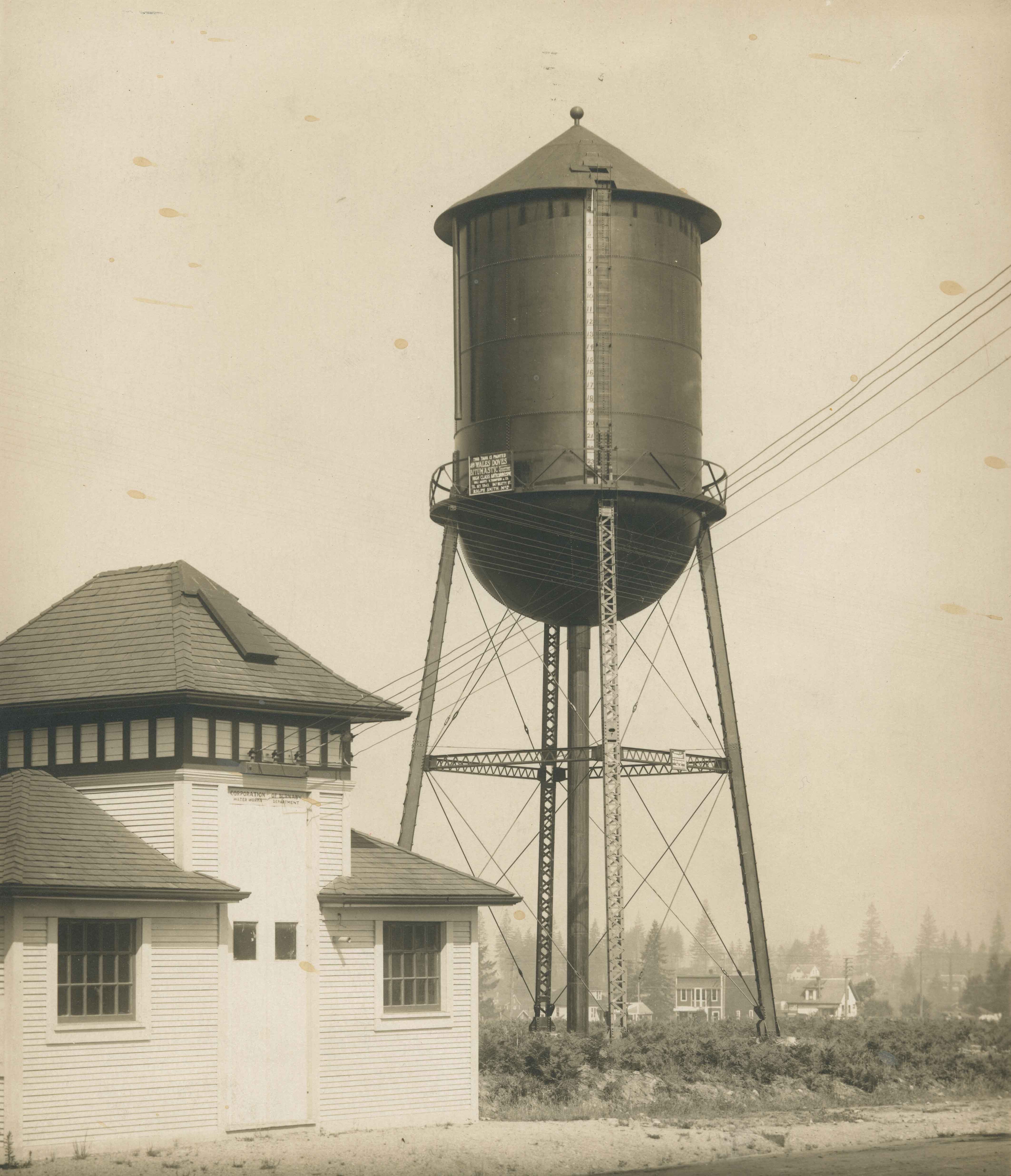
Water tank and pump house
https://search.heritageburnaby.ca/link/archivedescription34557
- Repository
- City of Burnaby Archives
- Date
- February 14, 1920
- Collection/Fonds
- Burnaby Historical Society fonds
- Description Level
- Item
- Physical Description
- 1 photograph : b&w ; 27.7 x 22.7 cm
- Scope and Content
- Photograph of the water tank and pump house at Central Park. A sign on the pump house reads, "Corporation of Burnaby / Water Works Department." A sign on the water tank reads, "This tank is painted with Wales Doves Bitumastic Solution / High Class Anti-Corrosive / Sales agents R. Thompson and Co. …
- Repository
- City of Burnaby Archives
- Date
- February 14, 1920
- Collection/Fonds
- Burnaby Historical Society fonds
- Subseries
- Photographs subseries
- Physical Description
- 1 photograph : b&w ; 27.7 x 22.7 cm
- Description Level
- Item
- Record No.
- 047-002
- Access Restriction
- No restrictions
- Reproduction Restriction
- No known restrictions
- Accession Number
- BHS2007-04
- Scope and Content
- Photograph of the water tank and pump house at Central Park. A sign on the pump house reads, "Corporation of Burnaby / Water Works Department." A sign on the water tank reads, "This tank is painted with Wales Doves Bitumastic Solution / High Class Anti-Corrosive / Sales agents R. Thompson and Co. / Tel. Sey. 5343, 847 Beatty St. / Ralph Smith Mgr." In the background, the Central Park Theatre is visible.
- Media Type
- Photograph
- Notes
- Title based on contents of photograph
- Stamp on back of photograph reads, "Feb. 14, 1920 / [illegible] Steel Co. Ltd."
- Geographic Access
- Central Park
- Imperial Street
- Street Address
- 3883 Imperial Street
- Historic Neighbourhood
- Central Park (Historic Neighbourhood)
- Planning Study Area
- Maywood Area
Images

Central Park
https://search.heritageburnaby.ca/link/archivedescription34862
- Repository
- City of Burnaby Archives
- Date
- 1920 (date of original), photographed 1985
- Collection/Fonds
- Burnaby Historical Society fonds
- Description Level
- Item
- Physical Description
- 1 photograph : b&w ; 8.8 x 11.3 cm
- Scope and Content
- Photograph of the Central Park entrance arch with the "Central Park" electric sign. An Interurban tram can be seen on the right. This photograph used to be hung at the Central Park branch of the Burnaby Public Library.
- Repository
- City of Burnaby Archives
- Date
- 1920 (date of original), photographed 1985
- Collection/Fonds
- Burnaby Historical Society fonds
- Subseries
- Evelyn Salisbury subseries
- Physical Description
- 1 photograph : b&w ; 8.8 x 11.3 cm
- Description Level
- Item
- Record No.
- 145-010
- Access Restriction
- No restrictions
- Reproduction Restriction
- No known restrictions
- Accession Number
- BHS1985-15
- Scope and Content
- Photograph of the Central Park entrance arch with the "Central Park" electric sign. An Interurban tram can be seen on the right. This photograph used to be hung at the Central Park branch of the Burnaby Public Library.
- Subjects
- Structures - Arches
- Advertising Medium - Signs and Signboards
- Geographic Features - Parks
- Transportation - Electric Railroads
- Media Type
- Photograph
- Notes
- Title based on contents of photograph
- Geographic Access
- Central Park
- Imperial Street
- Street Address
- 3883 Imperial Street
- Historic Neighbourhood
- Central Park (Historic Neighbourhood)
- Planning Study Area
- Maywood Area
Images

![Elgin Avenue farmhouse, [between 1920 and 1925] (date of original), copied 1986 thumbnail](/media/hpo/_Data/_Archives_Images/_Unrestricted/126/179-005.jpg?width=280)
Elgin Avenue farmhouse
https://search.heritageburnaby.ca/link/archivedescription35034
- Repository
- City of Burnaby Archives
- Date
- [between 1920 and 1925] (date of original), copied 1986
- Collection/Fonds
- Burnaby Historical Society fonds
- Description Level
- Item
- Physical Description
- 1 photograph : b&w ; 8.7 x 12.7 cm print
- Scope and Content
- Photograph of the exterior of an Elgin Avenue farmhouse and surrounding property. The farmhouse is at the left side of the photograph, and a chicken barn is at the right side. This may be 6389 Elgin Avenue.
- Repository
- City of Burnaby Archives
- Date
- [between 1920 and 1925] (date of original), copied 1986
- Collection/Fonds
- Burnaby Historical Society fonds
- Subseries
- Chamberlain family subseries
- Physical Description
- 1 photograph : b&w ; 8.7 x 12.7 cm print
- Description Level
- Item
- Record No.
- 179-005
- Access Restriction
- No restrictions
- Reproduction Restriction
- No known restrictions
- Accession Number
- BHS1986-27
- Scope and Content
- Photograph of the exterior of an Elgin Avenue farmhouse and surrounding property. The farmhouse is at the left side of the photograph, and a chicken barn is at the right side. This may be 6389 Elgin Avenue.
- Media Type
- Photograph
- Notes
- Title based on contents of photograph
- Geographic Access
- Elgin Avenue
- Street Address
- 6389 Elgin Avenue
- Historic Neighbourhood
- Central Park (Historic Neighbourhood)
- Planning Study Area
- Windsor Area
Images
![Elgin Avenue farmhouse, [between 1920 and 1925] (date of original), copied 1986 thumbnail](/media/hpo/_Data/_Archives_Images/_Unrestricted/126/179-005.jpg)
![Chamberlain Chicken Coop, [ca. 1920] (date of original), copied 1986 thumbnail](/media/hpo/_Data/_Archives_Images/_Unrestricted/126/179-006.jpg?width=280)
Chamberlain Chicken Coop
https://search.heritageburnaby.ca/link/archivedescription35035
- Repository
- City of Burnaby Archives
- Date
- [ca. 1920] (date of original), copied 1986
- Collection/Fonds
- Burnaby Historical Society fonds
- Description Level
- Item
- Physical Description
- 1 photograph : b&w ; 8.8 x 12.6 cm print
- Scope and Content
- Photograph of the exterior of the Chamberlain family chicken coop. The coop was originally a house. A man and three cows are seen outside it. This may be 6389 Elgin Avenue.
- Repository
- City of Burnaby Archives
- Date
- [ca. 1920] (date of original), copied 1986
- Collection/Fonds
- Burnaby Historical Society fonds
- Subseries
- Chamberlain family subseries
- Physical Description
- 1 photograph : b&w ; 8.8 x 12.6 cm print
- Description Level
- Item
- Record No.
- 179-006
- Access Restriction
- No restrictions
- Reproduction Restriction
- No known restrictions
- Accession Number
- BHS1986-27
- Scope and Content
- Photograph of the exterior of the Chamberlain family chicken coop. The coop was originally a house. A man and three cows are seen outside it. This may be 6389 Elgin Avenue.
- Subjects
- Animals - Cows
- Buildings - Agricultural
- Media Type
- Photograph
- Notes
- Title based on contents of photograph
- Street Address
- 6389 Elgin Avenue
- Historic Neighbourhood
- Central Park (Historic Neighbourhood)
- Planning Study Area
- Windsor Area
Images
![Chamberlain Chicken Coop, [ca. 1920] (date of original), copied 1986 thumbnail](/media/hpo/_Data/_Archives_Images/_Unrestricted/126/179-006.jpg)
![Jubilee Avenue, [192-] (date of original), copied 1986 thumbnail](/media/hpo/_Data/_Archives_Images/_Unrestricted/126/187-002.jpg?width=280)
Jubilee Avenue
https://search.heritageburnaby.ca/link/archivedescription35069
- Repository
- City of Burnaby Archives
- Date
- [192-] (date of original), copied 1986
- Collection/Fonds
- Burnaby Historical Society fonds
- Description Level
- Item
- Physical Description
- 1 photograph : b&w ; 11.4 x 7.1 cm
- Scope and Content
- Photograph of stores on Jubilee Avenue looking north from Imperial Street (later the location of Bonsor Park, 6550 Bonsor Avenue). Signs visible read; "Jubilee Drug Store," "Drugs," "Jubilee [Mercantile?] Co. / Groceries," "Nabob Tea," and "[Carvers or Corvers]." An accompanying description in the…
- Repository
- City of Burnaby Archives
- Date
- [192-] (date of original), copied 1986
- Collection/Fonds
- Burnaby Historical Society fonds
- Subseries
- Heyworth family subseries
- Physical Description
- 1 photograph : b&w ; 11.4 x 7.1 cm
- Description Level
- Item
- Record No.
- 187-002
- Access Restriction
- No restrictions
- Reproduction Restriction
- No known restrictions
- Accession Number
- BHS1986-38
- Scope and Content
- Photograph of stores on Jubilee Avenue looking north from Imperial Street (later the location of Bonsor Park, 6550 Bonsor Avenue). Signs visible read; "Jubilee Drug Store," "Drugs," "Jubilee [Mercantile?] Co. / Groceries," "Nabob Tea," and "[Carvers or Corvers]." An accompanying description in the accession file states that a man named Pat Flannagan ran the grocery.
- Media Type
- Photograph
- Notes
- Title based on contents of photograph
- Stamp on verso of photograph reads: "5272"
- Geographic Access
- Jubilee Avenue
- Bonsor Avenue
- Street Address
- 6550 Bonsor Avenue
- Historic Neighbourhood
- Central Park (Historic Neighbourhood)
- Planning Study Area
- Marlborough Area
Images
![Jubilee Avenue, [192-] (date of original), copied 1986 thumbnail](/media/hpo/_Data/_Archives_Images/_Unrestricted/126/187-002.jpg)
![G.R. Heyworth, [192-] (date of original), copied 1986 thumbnail](/media/hpo/_Data/_Archives_Images/_Unrestricted/126/187-004.jpg?width=280)
G.R. Heyworth
https://search.heritageburnaby.ca/link/archivedescription35071
- Repository
- City of Burnaby Archives
- Date
- [192-] (date of original), copied 1986
- Collection/Fonds
- Burnaby Historical Society fonds
- Description Level
- Item
- Physical Description
- 1 photograph : b&w ; 14.7 x 8.9 cm
- Scope and Content
- Photograph of G.R. Heyworth standing outside Jubilee Drug Store, Jubilee Avenue and Imperial Street (later the location of Bonsor Park, 6550 Bonsor Avenue). Signs read, "Jubilee Drug [Store] / G.R. [Heyworth]" and "Ask for Keystone Brand School Supplies." Magazines and school supplies are display…
- Repository
- City of Burnaby Archives
- Date
- [192-] (date of original), copied 1986
- Collection/Fonds
- Burnaby Historical Society fonds
- Subseries
- Heyworth family subseries
- Physical Description
- 1 photograph : b&w ; 14.7 x 8.9 cm
- Description Level
- Item
- Record No.
- 187-004
- Access Restriction
- No restrictions
- Reproduction Restriction
- No known restrictions
- Accession Number
- BHS1986-38
- Scope and Content
- Photograph of G.R. Heyworth standing outside Jubilee Drug Store, Jubilee Avenue and Imperial Street (later the location of Bonsor Park, 6550 Bonsor Avenue). Signs read, "Jubilee Drug [Store] / G.R. [Heyworth]" and "Ask for Keystone Brand School Supplies." Magazines and school supplies are displayed in the window. Note the dirt road.
- Media Type
- Photograph
- Notes
- Title based on contents of photograph
- Stamp on verso of photograph reads: "5580"
- Geographic Access
- Jubilee Avenue
- Bonsor Avenue
- Street Address
- 6550 Bonsor Avenue
- Historic Neighbourhood
- Central Park (Historic Neighbourhood)
- Planning Study Area
- Marlborough Area
Images
![G.R. Heyworth, [192-] (date of original), copied 1986 thumbnail](/media/hpo/_Data/_Archives_Images/_Unrestricted/126/187-004.jpg)
![Ada Smith and her friend, [1920] (date of original), copied 1986 thumbnail](/media/hpo/_Data/_Archives_Images/_Unrestricted/204/204-313.jpg?width=280)
Ada Smith and her friend
https://search.heritageburnaby.ca/link/archivedescription35455
- Repository
- City of Burnaby Archives
- Date
- [1920] (date of original), copied 1986
- Collection/Fonds
- Burnaby Historical Society fonds
- Description Level
- Item
- Physical Description
- 1 photograph : b&w ; 12.7 x 17.8 cm print
- Scope and Content
- Photograph of (right) Ada Smith and an unidentified friend. Ada was the daughter of James Smith and Agnes Smith, and lived in one of the first homes built at 6186 Royal Oak Road. This photograph was probably taken in the back yard of the family home.
- Repository
- City of Burnaby Archives
- Date
- [1920] (date of original), copied 1986
- Collection/Fonds
- Burnaby Historical Society fonds
- Subseries
- Pioneer Tales subseries
- Physical Description
- 1 photograph : b&w ; 12.7 x 17.8 cm print
- Description Level
- Item
- Record No.
- 204-313
- Access Restriction
- No restrictions
- Reproduction Restriction
- No known restrictions
- Accession Number
- BHS1988-03
- Scope and Content
- Photograph of (right) Ada Smith and an unidentified friend. Ada was the daughter of James Smith and Agnes Smith, and lived in one of the first homes built at 6186 Royal Oak Road. This photograph was probably taken in the back yard of the family home.
- Names
- Smith, Ada
- Media Type
- Photograph
- Notes
- Title based on contents of photograph
- Geographic Access
- Royal Oak Avenue
- Street Address
- 6186 Royal Oak Avenue
- Historic Neighbourhood
- Central Park (Historic Neighbourhood)
- Planning Study Area
- Windsor Area
Images
![Ada Smith and her friend, [1920] (date of original), copied 1986 thumbnail](/media/hpo/_Data/_Archives_Images/_Unrestricted/204/204-313.jpg)