
6410 Denbigh Avenue
https://search.heritageburnaby.ca/link/archivedescription98667
- Repository
- City of Burnaby Archives
- Date
- 2022
- Collection/Fonds
- Disappearing Burnaby collection
- Description Level
- Item
- Physical Description
- 1 photograph (jpeg) : col.
- Scope and Content
- Photograph of the exterior of a single-storey house located at 6410 Denbigh Avenue, taken from across the street at dusk. The house was constructed in 1949. Lights illuminate the front porch and the interior of one of the house's windows and there is a small amount of snow on the lawn in front of t…
- Repository
- City of Burnaby Archives
- Date
- 2022
- Collection/Fonds
- Disappearing Burnaby collection
- Physical Description
- 1 photograph (jpeg) : col.
- Description Level
- Item
- Record No.
- 634-014
- Access Restriction
- No restrictions
- Reproduction Restriction
- No restrictions
- Accession Number
- 2022-14
- Scope and Content
- Photograph of the exterior of a single-storey house located at 6410 Denbigh Avenue, taken from across the street at dusk. The house was constructed in 1949. Lights illuminate the front porch and the interior of one of the house's windows and there is a small amount of snow on the lawn in front of the house.
- Media Type
- Photograph
- Photographer
- Cheung, Nakita
- Notes
- Title taken from the associated blog post
- Associated blog post: https://disappearingburnaby.wordpress.com/2022/05/15/denbigh-ave/
- Geographic Access
- Denbigh Avenue
- Street Address
- 6410 Denbigh Avenue
- Historic Neighbourhood
- Central Park (Historic Neighbourhood)
- Planning Study Area
- Windsor Area
Images


6508 Silver Avenue
https://search.heritageburnaby.ca/link/archivedescription98678
- Repository
- City of Burnaby Archives
- Date
- 2022
- Collection/Fonds
- Disappearing Burnaby collection
- Description Level
- Item
- Physical Description
- 1 photograph (jpeg) : col.
- Scope and Content
- Photograph of the corner and side of the exterior of a concrete low-rise apartment building located at 6508 Silver Avenue. The photograph depicts the building at dusk. Some of the apartment windows are lit up from inside, and plant pots are lined up along the third-floor balcony. A chain link fence…
- Repository
- City of Burnaby Archives
- Date
- 2022
- Collection/Fonds
- Disappearing Burnaby collection
- Physical Description
- 1 photograph (jpeg) : col.
- Description Level
- Item
- Record No.
- 634-025
- Access Restriction
- No restrictions
- Reproduction Restriction
- No restrictions
- Accession Number
- 2022-14
- Scope and Content
- Photograph of the corner and side of the exterior of a concrete low-rise apartment building located at 6508 Silver Avenue. The photograph depicts the building at dusk. Some of the apartment windows are lit up from inside, and plant pots are lined up along the third-floor balcony. A chain link fence surrounds the backyard. The building was constructed in 1966.
- Media Type
- Photograph
- Photographer
- Cheung, Nakita
- Notes
- Title taken from the associated blog post
- Associated blog post: https://disappearingburnaby.wordpress.com/2022/06/30/brutalist/
- Geographic Access
- Silver Avenue
- Street Address
- 6508 Silver Avenue
- Historic Neighbourhood
- Central Park (Historic Neighbourhood)
- Planning Study Area
- Maywood Area
Images


6615 Telford Avenue
https://search.heritageburnaby.ca/link/archivedescription98674
- Repository
- City of Burnaby Archives
- Date
- 2022
- Collection/Fonds
- Disappearing Burnaby collection
- Description Level
- Item
- Physical Description
- 1 photograph (jpeg) : col.
- Scope and Content
- Photograph of the entrance, including the front steps and ramp, to a low-rise apartment building located at 6615 Telford Avenue. The building was constructed in 1964. The photograph depicts the building at night, and trees and bushes partially obscure the entrance. The building's lobby is illuminat…
- Repository
- City of Burnaby Archives
- Date
- 2022
- Collection/Fonds
- Disappearing Burnaby collection
- Physical Description
- 1 photograph (jpeg) : col.
- Description Level
- Item
- Record No.
- 634-021
- Access Restriction
- No restrictions
- Reproduction Restriction
- No restrictions
- Accession Number
- 2022-14
- Scope and Content
- Photograph of the entrance, including the front steps and ramp, to a low-rise apartment building located at 6615 Telford Avenue. The building was constructed in 1964. The photograph depicts the building at night, and trees and bushes partially obscure the entrance. The building's lobby is illuminated and the apartments' mailboxes are visible through the window.
- Media Type
- Photograph
- Photographer
- Cheung, Nakita
- Notes
- Title taken from the associated blog post
- Associated blog post: https://disappearingburnaby.wordpress.com/2022/06/09/martello-group/
- Geographic Access
- Telford Avenue
- Street Address
- 6615 Telford Avenue
- Historic Neighbourhood
- Central Park (Historic Neighbourhood)
- Planning Study Area
- Maywood Area
Images

6622 Willingdon
https://search.heritageburnaby.ca/link/archivedescription93741
- Repository
- City of Burnaby Archives
- Date
- 1989
- Collection/Fonds
- Grover, Elliott & Co. Ltd. fonds
- Description Level
- File
- Physical Description
- 14 photographs : col. negatives ; 35 mm + 3 photographs : col. ; 10 cm x 15 cm
- Scope and Content
- Photographs of the exterior of a three-storey apartment complex located at 6622 Willingdon Avenue, an unidentified industrial complex (Norland), and Heywood Park Place.
- Repository
- City of Burnaby Archives
- Date
- 1989
- Collection/Fonds
- Grover, Elliott & Co. Ltd. fonds
- Physical Description
- 14 photographs : col. negatives ; 35 mm + 3 photographs : col. ; 10 cm x 15 cm
- Description Level
- File
- Record No.
- 622-026
- Access Restriction
- No restrictions
- Reproduction Restriction
- No restrictions
- Accession Number
- 2017-39
- Scope and Content
- Photographs of the exterior of a three-storey apartment complex located at 6622 Willingdon Avenue, an unidentified industrial complex (Norland), and Heywood Park Place.
- Media Type
- Photograph
- Notes
- Transcribed title
- Title transcribed from print envelope photographs were originally housed in
- File no. 89-235-B
- Photographs 622-026-15 : 622-026-17 depict 6622 Willingdon Avenue
- Geographic Access
- Willingdon Avenue
- Street Address
- 6622 Willingdon Avenue
- Historic Neighbourhood
- Central Park (Historic Neighbourhood)
- Planning Study Area
- Maywood Area

6692 Dow Avenue
https://search.heritageburnaby.ca/link/archivedescription98662
- Repository
- City of Burnaby Archives
- Date
- 2022
- Collection/Fonds
- Disappearing Burnaby collection
- Description Level
- Item
- Physical Description
- 1 photograph (jpeg) : col.
- Scope and Content
- Photograph of the exterior of a two-storey apartment building located at 6692 Dow Avenue. The photograph depicts the building from across the street at night; the lobby and some of the apartment windows are lit up, with a bunch of balloons in one window, and a car is parked on the street in front o…
- Repository
- City of Burnaby Archives
- Date
- 2022
- Collection/Fonds
- Disappearing Burnaby collection
- Physical Description
- 1 photograph (jpeg) : col.
- Description Level
- Item
- Record No.
- 634-009
- Access Restriction
- No restrictions
- Reproduction Restriction
- No restrictions
- Accession Number
- 2022-14
- Scope and Content
- Photograph of the exterior of a two-storey apartment building located at 6692 Dow Avenue. The photograph depicts the building from across the street at night; the lobby and some of the apartment windows are lit up, with a bunch of balloons in one window, and a car is parked on the street in front of the building. The building was constructed in 1959.
- Media Type
- Photograph
- Photographer
- Cheung, Nakita
- Notes
- Title taken from the associated blog post
- Associated blog post: https://disappearingburnaby.wordpress.com/2022/03/01/dow-ave/
- Geographic Access
- Dow Avenue
- Street Address
- 6692 Dow Avenue
- Historic Neighbourhood
- Central Park (Historic Neighbourhood)
- Planning Study Area
- Maywood Area
Images


6700 Dow Avenue
https://search.heritageburnaby.ca/link/archivedescription98663
- Repository
- City of Burnaby Archives
- Date
- 2022
- Collection/Fonds
- Disappearing Burnaby collection
- Description Level
- Item
- Physical Description
- 1 photograph (jpeg) : col.
- Scope and Content
- Photograph of the entrance to an apartment building located at 6700 Dow Avenue. The photograph depicts the building at night; the lobby and stairs are illuminated by exterior and interior lights. The building was constructed in 1968.
- Repository
- City of Burnaby Archives
- Date
- 2022
- Collection/Fonds
- Disappearing Burnaby collection
- Physical Description
- 1 photograph (jpeg) : col.
- Description Level
- Item
- Record No.
- 634-010
- Access Restriction
- No restrictions
- Reproduction Restriction
- No restrictions
- Accession Number
- 2022-14
- Scope and Content
- Photograph of the entrance to an apartment building located at 6700 Dow Avenue. The photograph depicts the building at night; the lobby and stairs are illuminated by exterior and interior lights. The building was constructed in 1968.
- Media Type
- Photograph
- Photographer
- Cheung, Nakita
- Notes
- Title taken from the associated blog post
- Associated blog post: https://disappearingburnaby.wordpress.com/2022/03/29/no-pes/
- Geographic Access
- Dow Avenue
- Street Address
- 6700 Dow Avenue
- Historic Neighbourhood
- Central Park (Historic Neighbourhood)
- Planning Study Area
- Maywood Area
Images

![Ada Smith and her friend, [1920] (date of original), copied 1986 thumbnail](/media/hpo/_Data/_Archives_Images/_Unrestricted/204/204-313.jpg?width=280)
Ada Smith and her friend
https://search.heritageburnaby.ca/link/archivedescription35455
- Repository
- City of Burnaby Archives
- Date
- [1920] (date of original), copied 1986
- Collection/Fonds
- Burnaby Historical Society fonds
- Description Level
- Item
- Physical Description
- 1 photograph : b&w ; 12.7 x 17.8 cm print
- Scope and Content
- Photograph of (right) Ada Smith and an unidentified friend. Ada was the daughter of James Smith and Agnes Smith, and lived in one of the first homes built at 6186 Royal Oak Road. This photograph was probably taken in the back yard of the family home.
- Repository
- City of Burnaby Archives
- Date
- [1920] (date of original), copied 1986
- Collection/Fonds
- Burnaby Historical Society fonds
- Subseries
- Pioneer Tales subseries
- Physical Description
- 1 photograph : b&w ; 12.7 x 17.8 cm print
- Description Level
- Item
- Record No.
- 204-313
- Access Restriction
- No restrictions
- Reproduction Restriction
- No known restrictions
- Accession Number
- BHS1988-03
- Scope and Content
- Photograph of (right) Ada Smith and an unidentified friend. Ada was the daughter of James Smith and Agnes Smith, and lived in one of the first homes built at 6186 Royal Oak Road. This photograph was probably taken in the back yard of the family home.
- Names
- Smith, Ada
- Media Type
- Photograph
- Notes
- Title based on contents of photograph
- Geographic Access
- Royal Oak Avenue
- Street Address
- 6186 Royal Oak Avenue
- Historic Neighbourhood
- Central Park (Historic Neighbourhood)
- Planning Study Area
- Windsor Area
Images
![Ada Smith and her friend, [1920] (date of original), copied 1986 thumbnail](/media/hpo/_Data/_Archives_Images/_Unrestricted/204/204-313.jpg)
![Allen Sharpe's First Store on Kingsway, [192-] (date of original), copied 1992 thumbnail](/media/hpo/_Data/_Archives_Images/_Unrestricted/315/315-051.jpg?width=280)
Allen Sharpe's First Store on Kingsway
https://search.heritageburnaby.ca/link/archivedescription36696
- Repository
- City of Burnaby Archives
- Date
- [192-] (date of original), copied 1992
- Collection/Fonds
- Burnaby Historical Society fonds
- Description Level
- Item
- Physical Description
- 1 photograph : b&w ; 13 x 8.5 cm print
- Scope and Content
- Photograph of the exterior of Allen Sharpe's first store on Kingsway (at Kathleen Avenue), a sign shop and store that also sold groceries and Mrs. Rose Sharpe's hand-made linens. The Sharpes bought the property in 1919.
- Repository
- City of Burnaby Archives
- Date
- [192-] (date of original), copied 1992
- Collection/Fonds
- Burnaby Historical Society fonds
- Subseries
- Burnaby Centennial Anthology subseries
- Physical Description
- 1 photograph : b&w ; 13 x 8.5 cm print
- Description Level
- Item
- Record No.
- 315-051
- Access Restriction
- No restrictions
- Reproduction Restriction
- No known restrictions
- Accession Number
- BHS1994-04
- Scope and Content
- Photograph of the exterior of Allen Sharpe's first store on Kingsway (at Kathleen Avenue), a sign shop and store that also sold groceries and Mrs. Rose Sharpe's hand-made linens. The Sharpes bought the property in 1919.
- Names
- Sharpe Signs
- Media Type
- Photograph
- Notes
- Title based on contents of photograph
- Geographic Access
- Kingsway
- Kathleen Avenue
- Street Address
- 4360 Kingsway
- Historic Neighbourhood
- Central Park (Historic Neighbourhood)
- Planning Study Area
- Maywood Area
Images
![Allen Sharpe's First Store on Kingsway, [192-] (date of original), copied 1992 thumbnail](/media/hpo/_Data/_Archives_Images/_Unrestricted/315/315-051.jpg)
![Allen Sharpe's Gas Station on Kingsway, [192-] (date of original), copied 1992 thumbnail](/media/hpo/_Data/_Archives_Images/_Unrestricted/315/315-049.jpg?width=280)
Allen Sharpe's Gas Station on Kingsway
https://search.heritageburnaby.ca/link/archivedescription36694
- Repository
- City of Burnaby Archives
- Date
- [192-] (date of original), copied 1992
- Collection/Fonds
- Burnaby Historical Society fonds
- Description Level
- Item
- Physical Description
- 1 photograph : b&w ; 8.7 x 12.6 cm print
- Scope and Content
- Photograph of Allen Sharpe's gas station on Kingsway (at Kathleen Avenue) with a group of men standing in front. Mr. Sharpe is on the right wearing a cap and tie. Signs on the building read, "Sharpe Service Garage / Shell Gasoline / Motor Oil / Tires."
- Repository
- City of Burnaby Archives
- Date
- [192-] (date of original), copied 1992
- Collection/Fonds
- Burnaby Historical Society fonds
- Subseries
- Burnaby Centennial Anthology subseries
- Physical Description
- 1 photograph : b&w ; 8.7 x 12.6 cm print
- Description Level
- Item
- Record No.
- 315-049
- Access Restriction
- No restrictions
- Reproduction Restriction
- No known restrictions
- Accession Number
- BHS1994-04
- Scope and Content
- Photograph of Allen Sharpe's gas station on Kingsway (at Kathleen Avenue) with a group of men standing in front. Mr. Sharpe is on the right wearing a cap and tie. Signs on the building read, "Sharpe Service Garage / Shell Gasoline / Motor Oil / Tires."
- Names
- Sharpe Service Garage
- Media Type
- Photograph
- Notes
- Title based on contents of photograph
- Geographic Access
- Kingsway
- Street Address
- 4360 Kingsway
- Historic Neighbourhood
- Central Park (Historic Neighbourhood)
- Planning Study Area
- Maywood Area
Images
![Allen Sharpe's Gas Station on Kingsway, [192-] (date of original), copied 1992 thumbnail](/media/hpo/_Data/_Archives_Images/_Unrestricted/315/315-049.jpg)

Alta Vista Baptist Church Sunday School class
https://search.heritageburnaby.ca/link/archivedescription35611
- Repository
- City of Burnaby Archives
- Date
- 1928
- Collection/Fonds
- Burnaby Historical Society fonds
- Description Level
- Item
- Physical Description
- 1 photograph : b&w ; 12.7 x 17.8 cm print
- Scope and Content
- Photograph of members of the Alta Vista Baptist Church Sunday school class at the Jubilee Interurban train Station, on the way to a Picnic at Second Beach. Included in the photograph are, from left; Pearl Christian, Joy [last name unknown], Phyllis Smith, Ivy Smith, Dorothy Douglas, Grace Harrison,…
- Repository
- City of Burnaby Archives
- Date
- 1928
- Collection/Fonds
- Burnaby Historical Society fonds
- Subseries
- Pioneer Tales subseries
- Physical Description
- 1 photograph : b&w ; 12.7 x 17.8 cm print
- Description Level
- Item
- Record No.
- 204-469
- Access Restriction
- No restrictions
- Reproduction Restriction
- No known restrictions
- Accession Number
- BHS1988-03
- Scope and Content
- Photograph of members of the Alta Vista Baptist Church Sunday school class at the Jubilee Interurban train Station, on the way to a Picnic at Second Beach. Included in the photograph are, from left; Pearl Christian, Joy [last name unknown], Phyllis Smith, Ivy Smith, Dorothy Douglas, Grace Harrison, [unidentified]. Mrs. Nellie Davis [not pictured] taught this class.
- Names
- Alta Vista Baptist Church
- British Columbia Electric Railway Company
- Christian, Pearl
- Smith, Phyllis
- Smith, Ivy
- Douglas, Dorothy
- Harrison, Grace
- Media Type
- Photograph
- Notes
- Title based on contents of photograph
- Geographic Access
- Central Park Interurban line
- Historic Neighbourhood
- Central Park (Historic Neighbourhood)
- Planning Study Area
- Maywood Area
Images

![Annie King, [1921] (date of original), copied 1991 thumbnail](/media/hpo/_Data/_Archives_Images/_Unrestricted/370/370-327.jpg?width=280)
Annie King
https://search.heritageburnaby.ca/link/archivedescription37739
- Repository
- City of Burnaby Archives
- Date
- [1921] (date of original), copied 1991
- Collection/Fonds
- Burnaby Historical Society fonds
- Description Level
- Item
- Physical Description
- 1 photograph : b&w ; 3.1 x 3.9 cm print on contact sheet 20.3 x 26.6 cm
- Scope and Content
- Photograph of Annie King in the yard of her family home at 4242 Grange Street (old numbering).
- Repository
- City of Burnaby Archives
- Date
- [1921] (date of original), copied 1991
- Collection/Fonds
- Burnaby Historical Society fonds
- Subseries
- Burnaby Image Bank subseries
- Physical Description
- 1 photograph : b&w ; 3.1 x 3.9 cm print on contact sheet 20.3 x 26.6 cm
- Description Level
- Item
- Record No.
- 370-327
- Access Restriction
- No restrictions
- Reproduction Restriction
- No known restrictions
- Accession Number
- BHS1999-03
- Scope and Content
- Photograph of Annie King in the yard of her family home at 4242 Grange Street (old numbering).
- Names
- Ellis, Annie King
- Media Type
- Photograph
- Notes
- Title based on contents of photograph
- 1 b&w copy negative accompanying
- Negative has a pink cast
- Geographic Access
- Grange Street
- Street Address
- 4242 Grange Street
- Historic Neighbourhood
- Central Park (Historic Neighbourhood)
- Planning Study Area
- Maywood Area
Images
![Annie King, [1921] (date of original), copied 1991 thumbnail](/media/hpo/_Data/_Archives_Images/_Unrestricted/370/370-327.jpg)
![Annie King in May Day outfit, [1926] (date of original), copied 1991 thumbnail](/media/hpo/_Data/_Archives_Images/_Unrestricted/370/370-347.jpg?width=280)
Annie King in May Day outfit
https://search.heritageburnaby.ca/link/archivedescription37759
- Repository
- City of Burnaby Archives
- Date
- [1926] (date of original), copied 1991
- Collection/Fonds
- Burnaby Historical Society fonds
- Description Level
- Item
- Physical Description
- 1 photograph : b&w ; 3.9 x 2.6 cm print on contact sheet 20.5 x 26.4 cm
- Scope and Content
- Photograph of Annie King in her May Day outfit, standing at the side of 4242 Grange Street (old numbering), the King family home.
- Repository
- City of Burnaby Archives
- Date
- [1926] (date of original), copied 1991
- Collection/Fonds
- Burnaby Historical Society fonds
- Subseries
- Burnaby Image Bank subseries
- Physical Description
- 1 photograph : b&w ; 3.9 x 2.6 cm print on contact sheet 20.5 x 26.4 cm
- Description Level
- Item
- Record No.
- 370-347
- Access Restriction
- No restrictions
- Reproduction Restriction
- No known restrictions
- Accession Number
- BHS1999-03
- Scope and Content
- Photograph of Annie King in her May Day outfit, standing at the side of 4242 Grange Street (old numbering), the King family home.
- Subjects
- Events - May Day
- Clothing
- Names
- Ellis, Annie King
- Media Type
- Photograph
- Notes
- Title based on contents of photograph
- 1 b&w copy negative accompanying
- Negative has a pink cast
- Geographic Access
- Grange Street
- Historic Neighbourhood
- Central Park (Historic Neighbourhood)
- Planning Study Area
- Maywood Area
Images
![Annie King in May Day outfit, [1926] (date of original), copied 1991 thumbnail](/media/hpo/_Data/_Archives_Images/_Unrestricted/370/370-347.jpg)

Armitage family home
https://search.heritageburnaby.ca/link/archivedescription35775
- Repository
- City of Burnaby Archives
- Date
- 1920 (date of original), copied 1986
- Collection/Fonds
- Burnaby Historical Society fonds
- Description Level
- Item
- Physical Description
- 1 photograph : b&w ; 12.7 x 17.8 cm print
- Scope and Content
- Photograph of the Armitage family home at 3276 Grimmer Street (later renumbered 5496 Grimmer Street), on the corner of Grimmer and Kingsway in South Burnaby. This was the second Armitage home and the second house built on this lot, the first having burned down.
- Repository
- City of Burnaby Archives
- Date
- 1920 (date of original), copied 1986
- Collection/Fonds
- Burnaby Historical Society fonds
- Subseries
- Pioneer Tales subseries
- Physical Description
- 1 photograph : b&w ; 12.7 x 17.8 cm print
- Description Level
- Item
- Record No.
- 204-633
- Access Restriction
- No restrictions
- Reproduction Restriction
- No known restrictions
- Accession Number
- BHS1988-03
- Scope and Content
- Photograph of the Armitage family home at 3276 Grimmer Street (later renumbered 5496 Grimmer Street), on the corner of Grimmer and Kingsway in South Burnaby. This was the second Armitage home and the second house built on this lot, the first having burned down.
- Subjects
- Buildings - Residential - Houses
- Media Type
- Photograph
- Notes
- Title based on contents of photograph
- Geographic Access
- Grimmer Street
- Street Address
- 5496 Grimmer Street
- Historic Neighbourhood
- Central Park (Historic Neighbourhood)
- Planning Study Area
- Windsor Area
Images

![Arthur Lobley and friends, [192-] thumbnail](/media/hpo/_Data/_BVM_Images/1976/1976_0236_0002_001.jpg?width=280)
Arthur Lobley and friends
https://search.heritageburnaby.ca/link/museumdescription894
- Repository
- Burnaby Village Museum
- Date
- [192-]
- Collection/Fonds
- Burnaby Village Museum Photograph collection
- Description Level
- Item
- Physical Description
- 1 photograph : b&w ; 6.6 x 11.2 cm
- Scope and Content
- Photograph of people on the front steps of the home of Arthur Lobley located on Marlborough Avenue, off Kingsway. Arthur Lobley is sitting in the front, and the rest of the group are standing behind him. They are identified as (left to right) Mrs. A. Lobley (Dolly) in hat, Winnie Patterson, Emma Su…
- Repository
- Burnaby Village Museum
- Collection/Fonds
- Burnaby Village Museum Photograph collection
- Description Level
- Item
- Physical Description
- 1 photograph : b&w ; 6.6 x 11.2 cm
- Scope and Content
- Photograph of people on the front steps of the home of Arthur Lobley located on Marlborough Avenue, off Kingsway. Arthur Lobley is sitting in the front, and the rest of the group are standing behind him. They are identified as (left to right) Mrs. A. Lobley (Dolly) in hat, Winnie Patterson, Emma Sully, and Jimmy Fitzpatrick. Beside them, a dog, identified as "old Dan" is sitting and looking towards the group. An annotation on the back of the photo reads: "I will send you some snaps of the wedding if they come out O.K."
- History
- Arthur Lobley immigrated to Canada in 1892. He married Dora Cooke (identified as Mrs. A. Lobley in photograph), likely in England. Arthur worked for the CPR and the couple lived at 2619 Marlborough Avenue in Burnaby. Along with his brother, Charles, Arthur was an early resident of the Central Park neighbourhood of Burnaby. According to George Green's book, "History of Burnaby," pg. 134, the Lobleys were an early pioneer family in Burnaby. Arthur Lobley is credited for opening the Royal Oak Road to the tram station at Royal Oak in 1897. Dora's aunt, Emma Sully and her husband John Sully were lodgers at the Lobley house on Marlborough Street. Dora's cousin, Winnifred Davis Patterson was also a lodger until her marriage to Carl Anderson in 1940.
- Subjects
- Animals - Dogs
- Geographic Access
- Marlborough Avenue
- Kingsway
- Accession Code
- HV976.236.2
- Access Restriction
- No restrictions
- Reproduction Restriction
- No known restrictions
- Date
- [192-]
- Media Type
- Photograph
- Historic Neighbourhood
- Central Park (Historic Neighbourhood)
- Planning Study Area
- Marlborough Area
- Scan Resolution
- 600
- Scan Date
- 2023-06-27
Images
![Arthur Lobley and friends, [192-] thumbnail](/media/hpo/_Data/_BVM_Images/1976/1976_0236_0002_001.jpg)
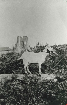
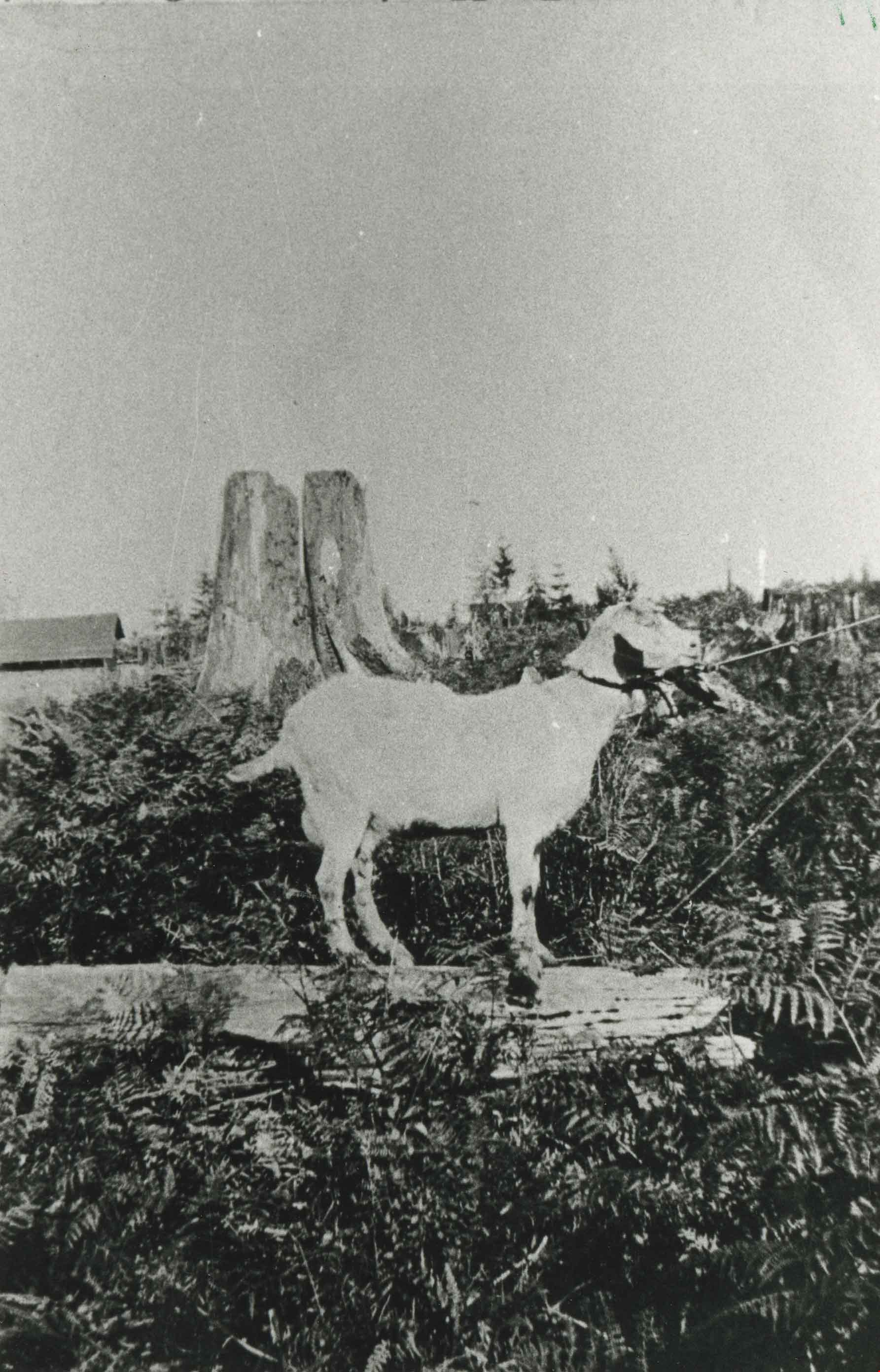
Beauty the goat
https://search.heritageburnaby.ca/link/archivedescription35259
- Repository
- City of Burnaby Archives
- Date
- 1923 (date of original), copied 1986
- Collection/Fonds
- Burnaby Historical Society fonds
- Description Level
- Item
- Physical Description
- 1 photograph : b&w ; 12.7 x 17.8 cm print
- Scope and Content
- Photograph of McMahon's pet goat, Beauty, on their Waltham Avenue "stump ranch" property, later numbered 6558 Waltham Avenue.
- Repository
- City of Burnaby Archives
- Date
- 1923 (date of original), copied 1986
- Collection/Fonds
- Burnaby Historical Society fonds
- Subseries
- Pioneer Tales subseries
- Physical Description
- 1 photograph : b&w ; 12.7 x 17.8 cm print
- Description Level
- Item
- Record No.
- 204-116
- Access Restriction
- No restrictions
- Reproduction Restriction
- No known restrictions
- Accession Number
- BHS1988-03
- Scope and Content
- Photograph of McMahon's pet goat, Beauty, on their Waltham Avenue "stump ranch" property, later numbered 6558 Waltham Avenue.
- Subjects
- Animals - Goats
- Media Type
- Photograph
- Notes
- Title based on contents of photograph
- Geographic Access
- Waltham Avenue
- Street Address
- 6558 Waltham Avenue
- Historic Neighbourhood
- Central Park (Historic Neighbourhood)
- Planning Study Area
- Windsor Area
Images
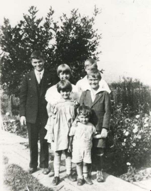
Bellinger and Baker children
https://search.heritageburnaby.ca/link/archivedescription35166
- Repository
- City of Burnaby Archives
- Date
- 1929 (date of original), copied 1986
- Collection/Fonds
- Burnaby Historical Society fonds
- Description Level
- Item
- Physical Description
- 1 photograph : b&w ; 12.7 x 17.8 cm print
- Scope and Content
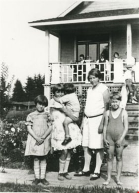
- Photograph of Bellinger children and friends. From left: Marion Bellinger, Christine Bellinger holding Robert "Bob" Bellinger, and two Baker children. Taken in front of Bellinger home at 6296 Earl Avenue, now called Pearl Avenue. Note the plank sidewalk.
- Repository
- City of Burnaby Archives
- Date
- 1929 (date of original), copied 1986
- Collection/Fonds
- Burnaby Historical Society fonds
- Subseries
- Pioneer Tales subseries
- Physical Description
- 1 photograph : b&w ; 12.7 x 17.8 cm print
- Description Level
- Item
- Record No.
- 204-023
- Access Restriction
- No restrictions
- Reproduction Restriction
- No known restrictions
- Accession Number
- BHS1988-03
- Scope and Content
- Photograph of Bellinger children and friends. From left: Marion Bellinger, Christine Bellinger holding Robert "Bob" Bellinger, and two Baker children. Taken in front of Bellinger home at 6296 Earl Avenue, now called Pearl Avenue. Note the plank sidewalk.
- Media Type
- Photograph
- Notes
- Title based on contents of photograph
- Geographic Access
- Pearl Avenue
- Street Address
- 6296 Earl Avenue
- Historic Neighbourhood
- Central Park (Historic Neighbourhood)
- Planning Study Area
- Windsor Area
Images

![Bellinger and Baker children, [1929 or 1930] (date of original), copied 1991 thumbnail](/media/hpo/_Data/_Archives_Images/_Unrestricted/370/370-063.jpg?width=280)
Bellinger and Baker children
https://search.heritageburnaby.ca/link/archivedescription37475
- Repository
- City of Burnaby Archives
- Date
- [1929 or 1930] (date of original), copied 1991
- Collection/Fonds
- Burnaby Historical Society fonds
- Description Level
- Item
- Physical Description
- 1 photograph : b&w ; 4.4 x 3.0 cm print on contact sheet 20.2 x 25.3 cm
- Scope and Content
- Photograph of five children standing on the board sidewalk in front of 2827 Earl Avenue (later 6296 Pearl Avenue). Left to right: Marion Bellinger, Christine Bellinger, Robert Bellinger, Barbara Baker, and Barbara's sister. Adults are seated on the porch behind them.
- Repository
- City of Burnaby Archives
- Date
- [1929 or 1930] (date of original), copied 1991
- Collection/Fonds
- Burnaby Historical Society fonds
- Subseries
- Burnaby Image Bank subseries
- Physical Description
- 1 photograph : b&w ; 4.4 x 3.0 cm print on contact sheet 20.2 x 25.3 cm
- Description Level
- Item
- Record No.
- 370-063
- Access Restriction
- No restrictions
- Reproduction Restriction
- Reproduce for fair dealing purposes only
- Accession Number
- BHS1999-03
- Scope and Content
- Photograph of five children standing on the board sidewalk in front of 2827 Earl Avenue (later 6296 Pearl Avenue). Left to right: Marion Bellinger, Christine Bellinger, Robert Bellinger, Barbara Baker, and Barbara's sister. Adults are seated on the porch behind them.
- Media Type
- Photograph
- Photographer
- Bellinger, Bernard
- Notes
- Title based on contents of photograph
- 1 b&w copy negative accompanying
- Geographic Access
- Pearl Avenue
- Street Address
- 6296 Pearl Avenue
- Historic Neighbourhood
- Central Park (Historic Neighbourhood)
- Planning Study Area
- Windsor Area
Images
![Bellinger and Baker children, [1929 or 1930] (date of original), copied 1991 thumbnail](/media/hpo/_Data/_Archives_Images/_Unrestricted/370/370-063.jpg)
Bellinger family
https://search.heritageburnaby.ca/link/archivedescription35167
- Repository
- City of Burnaby Archives
- Date
- 1929 (date of original), copied 1986
- Collection/Fonds
- Burnaby Historical Society fonds
- Description Level
- Item
- Physical Description
- 1 photograph : b&w ; 12.7 x 17.8 cm print
- Scope and Content
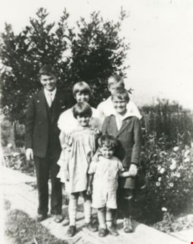
- Photograph of the Bellinger family children. Back row: Bernard Bellinger, Christine Bellinger and David Bellinger. Middle row: Marion Bellinger and James Bellinger. Front row: Robert "Bob" Bellinger. Taken in front of the Bellinger family home at 6296 Earl Avenue, now called Pearl Avenue.
- Repository
- City of Burnaby Archives
- Date
- 1929 (date of original), copied 1986
- Collection/Fonds
- Burnaby Historical Society fonds
- Subseries
- Pioneer Tales subseries
- Physical Description
- 1 photograph : b&w ; 12.7 x 17.8 cm print
- Description Level
- Item
- Record No.
- 204-024
- Access Restriction
- No restrictions
- Reproduction Restriction
- No known restrictions
- Accession Number
- BHS1988-03
- Scope and Content
- Photograph of the Bellinger family children. Back row: Bernard Bellinger, Christine Bellinger and David Bellinger. Middle row: Marion Bellinger and James Bellinger. Front row: Robert "Bob" Bellinger. Taken in front of the Bellinger family home at 6296 Earl Avenue, now called Pearl Avenue.
- Names
- Bellinger, Bernard
- Bellinger, Christine
- Bellinger, David
- Bellinger, James
- Bellinger, Marion
- Bellinger, Robert "Bob"
- Media Type
- Photograph
- Notes
- Title based on contents of photograph
- Geographic Access
- Pearl Avenue
- Street Address
- 6296 Earl Avenue
- Historic Neighbourhood
- Central Park (Historic Neighbourhood)
- Planning Study Area
- Windsor Area
Images

Bonsor Hall
https://search.heritageburnaby.ca/link/archivedescription38282
- Repository
- City of Burnaby Archives
- Date
- 1986
- Collection/Fonds
- Burnaby Historical Society fonds
- Description Level
- Item
- Physical Description
- 1 photograph : col. ; 10 x 13 cm
- Scope and Content
- Photograph of the Bonsor Hall (originally 6637 Fern Avenue). In the foreground, construction debris can be seen and the skytrain is visible in the background. A note with this photograph indicates that this building was originally the Burnaby School Board Office.
- Repository
- City of Burnaby Archives
- Date
- 1986
- Collection/Fonds
- Burnaby Historical Society fonds
- Subseries
- Photographs subseries
- Physical Description
- 1 photograph : col. ; 10 x 13 cm
- Description Level
- Item
- Record No.
- 386-001
- Access Restriction
- No restrictions
- Reproduction Restriction
- Reproduce for fair dealing purposes only
- Accession Number
- BHS2007-04
- Scope and Content
- Photograph of the Bonsor Hall (originally 6637 Fern Avenue). In the foreground, construction debris can be seen and the skytrain is visible in the background. A note with this photograph indicates that this building was originally the Burnaby School Board Office.
- Names
- Bonsor Hall
- Media Type
- Photograph
- Notes
- Title based on contents of photograph.
- Geographic Access
- Fern Avenue
- Historic Neighbourhood
- Central Park (Historic Neighbourhood)
- Planning Study Area
- Marlborough Area
Images

![Burnaby Girl Guides, [1914]-1969, predominant ca. 1920 (date of original), copied 2016 thumbnail](/media/hpo/_Data/_BVM_Images/2015/2015_0035_0164_folded.jpg?width=280)
Burnaby Girl Guides
https://search.heritageburnaby.ca/link/museumdescription4592
- Repository
- Burnaby Village Museum
- Date
- [1914]-1969, predominant ca. 1920 (date of original), copied 2016
- Collection/Fonds
- Burnaby Girl Guides fonds
- Description Level
- File
- Physical Description
- 1 scrapbook (textual records + 2 digital files : (pdfs) + 102 photographs : (tiffs))
- Scope and Content
- File consists of images and selected contents from a scrapbook with 38 double sided pages containing mostly photographs with some newspaper clippings, written material and emphemera including a page of badges and ribbons which reads "Enrolment & Membership Card of / Joan Bailey 1926 / 1st Burnaby" …
- Repository
- Burnaby Village Museum
- Collection/Fonds
- Burnaby Girl Guides fonds
- Description Level
- File
- Physical Description
- 1 scrapbook (textual records + 2 digital files : (pdfs) + 102 photographs : (tiffs))
- Scope and Content
- File consists of images and selected contents from a scrapbook with 38 double sided pages containing mostly photographs with some newspaper clippings, written material and emphemera including a page of badges and ribbons which reads "Enrolment & Membership Card of / Joan Bailey 1926 / 1st Burnaby" and an embroidered alphabet of the Morse Code. The third page of the scrapbook includes a four page chronology titled "History of Guiding - Burnaby / 1913 - 1960" compiled by Mrs. Dolly Weber, Mrs. J. Heaps, Miss Eileen Periton, Mrs. J. Albertson and D. Fowler. The scrapbook also includes an original letter and post-script from Lady Olave Baden-Powell to Mrs. Fowler dated November 5, 1961; a typewritten copy of: "TSOONA" / PROVINCIAL GUIDE CAMPSITE - ROSEDALE B.C." and a three page typewritten copy of "THE CAMPFIRE / Volume 1, No. 4 _ November 1935 _ Vancouver, B.C.". Many of the events documented in photographs [between 1914 and 1969] are identified on each page and read as the following: "Burnaby Brownies - Guides & Rangers" / "Early 1920" (1 photograph); "Ambulance / Display / 1st. Co."; "Girl Guide Rally - New Westminster and / Burnaby - June 16, 1923" (5 photographs); "Girl Guide Rally - New Westminster and / Burnaby - June 16, 1923" (5 photographs); "Burnaby Guides and / Brownies / June 17, 1923" (5 photographs); "April 1923" (1 photograph); "June 1923 / 2nd Burnaby Company" (1 photograph); "Burnaby May Day / 26.5.28"(2 photographs); "Sechelt 1929_ 2nd "B" Company" (2 photographs); "Leaders and Seconds / 2nd Burnaby / Grouse Mountain" (1 photograph); "Sechelt 1929 / Commandant Mrs. Peal" (1 photograph); "2nd Company / June 1930" (1 photograph); "1932 / 2nd Company at Rally / Municipal Hall Grounds" (1 photograph) ; "First Burnaby Folk Dancing team / Winners of the E.F.D. cup 1940--41-42" (1 photograph); "1st Burnaby Company / winners of Bessborough Shield / 1942 / Captain L. Crane" (1 photograph); "May 6th 1935 / Dedication of flag at Central Park" (1 photograph); "May Day Celebration / Burnaby B.C. May 6th 1935 / Stride Studios Photos" (1 photograph); "Mrs. Don Wilks / Mrs. Georgie / Runcie / Publicity Photo re- / Brownie / Training / 1958-60" (1 photograph); "Kathleen Anderson / about 1958-60?" (1 photograph); "1957 / Burnaby Camp Site / at / Wilson Creek" (1 photograph); "Work Party (1958)" (1 photograph); "Burnaby Camp Site / Spring 1958 / Cabins & Staff Houses / Dining Shelter / Cabins" (3 photographs); "Can. Girl Guide Assoc. - Provincial Leaders Conference / April 14-15/61 Civic Centre, Prince George, BC" (1 photograph) ; "June 8th, 1958 / Opening / Ceremonies / Burnaby Site / Wilson Creek / Camp Site" (4 photographs); 2 unidentified photographs [ca.1915] of a large group of Girl Guides gathered on the Pacific National Exhibition grounds (photo credit- Leonard Frank); 1 unidentified photograph of a group of Girl Guides gathered for a group portrait [ca.1914]; "Girl Guide Camp / Granthams / Landing / July 1923" (4 photographs); 4 unidentified photographs of girl guides gathered on the ship "Lady Evelyn" [ca. 1920]; "Burnaby Girl Guides" 1918; "First Burnaby Girl Guides 1920" (2 photographs on page); "2nd Co. 1923" (1 photograph) "1st Burnaby Co." [1923] (1 photograph); "Gypsy Scene - Concert / Mar 17, 1923 / Unveiling / War / Memorial / Edmonds / 1923" (3 photographs on page); "Faith Jacobson / 1961" (2 photographs); "Eve MacLean / 1961" (1 photograph); "Beverley Simkin of Montreal and Judy Robins / of the S.R.S. Royal Oak taken on the day they / sailed from Montreal for the Ranger Camp at / "Our Chalet" in Adelboden, Switzerland, May 1962" (1 photograph) and "Religion & Life Emblem / Diane Peters 11th Bby. Co. / Rev. G.W. Luetkehodeter / 1961" (2 photographs on one page).
- Names
- Girl Guides of Canada
- Accession Code
- BV015.35.164
- Access Restriction
- No restrictions
- Reproduction Restriction
- May be restricted by third party rights
- Date
- [1914]-1969, predominant ca. 1920 (date of original), copied 2016
- Media Type
- Photograph
- Textual Record
- Historic Neighbourhood
- Edmonds (Historic Neighbourhood)
- Central Park (Historic Neighbourhood)
- Planning Study Area
- Edmonds Area
- Maywood Area
- Notes
- Transcribed title
- Digital images were created of the scrapbook prior to selective retention of original records that were removed for conservation purposes
- Some textual records that were selected for retention have been described at file level under BV015.35.164: "Tsoona" Provincial Guide Campsite - Rosedale B.C." and Burnaby Girl Guides newsletter, "The Campfire" (November 1935)
- Photographs that were retained from scrapbook have been described at item level (BV015.35.221 to BV015.35.284)
- Some textual records and ephemera that were selected for retention have been described at item level (BV015.35.320, BV015.35.321, and BV015.35.334 to BV015.35.348).
Images
![Burnaby Girl Guides, [1914]-1969, predominant ca. 1920 (date of original), copied 2016 thumbnail](/media/hpo/_Data/_BVM_Images/2015/2015_0035_0164_folded.jpg)