Narrow Results By
Subject
- Advertising Medium - Signs and Signboards 1
- Animals - Cats 1
- Arts - Paintings 1
- Buildings - Commercial 4
- Buildings - Commercial - General Stores 2
- Buildings - Commercial - Stores 1
- Buildings - Commercial - Train Stations 1
- Buildings - Recreational - Community Halls 1
- Buildings - Religious - Churches 2
- Buildings - Residential - Houses 6
- Documentary Artifacts - Postcards 2
- Geographic Features - Roads 2

Central Park Neighbourhood
https://search.heritageburnaby.ca/link/landmark723
- Repository
- Burnaby Heritage Planning
- Associated Dates
- 1891-1904
- Heritage Value
- Central Park was one of the first and fastest-growing communities in Burnaby. Located along the electric tram line and the Vancouver Road (Kingsway), it was also chosen for a government settlement project referred to as the Central Park Small Holdings. The lands held by the Provincial Government were subdivided and sold around 1894 and by 1899 the settlement was large enough to warrant the construction of an Anglican Church there.
- Historic Neighbourhood
- Central Park (Historic Neighbourhood)
- Planning Study Area
- Maywood Area
Images


Central Park Neighbourhood
https://search.heritageburnaby.ca/link/landmark751
- Repository
- Burnaby Heritage Planning
- Associated Dates
- 1905-1924
- Heritage Value
- In 1906, Maxwell Smith, President of the Central Park Farmer's Institute gave a speech in which he commented on the growth of this district and its ideal location during the boom years after 1905. He said: "Central Park is destined to become the epicentre of a great commercial metropolis, when Vancouver and New Westminster will have both expanded and prospered until they meet and fill up the intervening distances with residences of a new city, greater than few can now imagine, even in their wildest flights of fancy...we are proud of the two cities that lie on either side of us but they are, but mere hamlets compared with the great city that is to be on this peninsula. The time is coming when there will be one vast city, one commercial metropolis, and Central Park will be the heart of it."
- Historic Neighbourhood
- Central Park (Historic Neighbourhood)
- Planning Study Area
- Maywood Area
Images


James & Agnes Smith Residence
https://search.heritageburnaby.ca/link/landmark601
- Repository
- Burnaby Heritage Planning
- Description
- Residential building.
- Associated Dates
- 1907
- Street View URL
- Google Maps Street View
- Repository
- Burnaby Heritage Planning
- Geographic Access
- Royal Oak Avenue
- Associated Dates
- 1907
- Description
- Residential building.
- Heritage Value
- During the Edwardian era, the western provinces were experiencing unprecedented population growth, and in response, in 1904 the Vancouver-based B.C. Mills, Timber and Trading Company patented a modular prefabricated building system that could be adapted to provide everything from modest one-room cottages to churches, schools and banks. Wall panels were assembled from the short mill ends of lumber and siding, until then just waste material that piled up in the millyard. These panels were bolted together on site, with the joints between the panels covered by distinctive vertical battens. Wall panels were assembled at the mill, pre-painted, and packaged with the other components and the instructions necessary to assemble the building. The disassembled building was then shipped to the waiting customer. As western settlements became established, labour and materials were more freely available and local construction companies could be more competitive in their costs. By 1910, this prefabricated system was rendered obsolete. The Smith Residence is a beautifully-preserved example of a B.C. Mills house, and is one of the models that featured a gambrel roof and a full open front verandah. This house was built by local contractor Mr. MacLean for James Smith, a ship’s engineer on the Empress of Japan, and his wife, Agnes. Agnes Smith continued to live here after her husband’s death and sold the house and property in the late 1920s with two of the acres being purchased by her daughter, Grace and husband Henry Pletcher to build a neighbouring house.
- Locality
- Central Park
- Historic Neighbourhood
- Central Park (Historic Neighbourhood)
- Planning Study Area
- Oakalla Area
- Area
- 1147.85
- Contributing Resource
- Building
- Ownership
- Private
- Street Address
- 6186 Royal Oak Avenue
- Street View URL
- Google Maps Street View
Images


Joseph Clarke House
https://search.heritageburnaby.ca/link/landmark505
- Repository
- Burnaby Heritage Planning
- Description
- The Joseph Clarke House is a two and one-half storey, wood-frame house, with shingle siding, a front-gabled roof and a full open front verandah. It is located on Jersey Avenue within the Central Park neighbourhood of Burnaby.
- Associated Dates
- 1909
- Formal Recognition
- Heritage Designation, Community Heritage Register
- Other Names
- Joseph & Ellen Clarke House, Clarke Residence
- Street View URL
- Google Maps Street View
- Repository
- Burnaby Heritage Planning
- Other Names
- Joseph & Ellen Clarke House, Clarke Residence
- Geographic Access
- Jersey Avenue
- Sandell Street
- Associated Dates
- 1909
- Formal Recognition
- Heritage Designation, Community Heritage Register
- Enactment Type
- By-law No. 11930
- Enactment Date
- 29/08/2005
- Description
- The Joseph Clarke House is a two and one-half storey, wood-frame house, with shingle siding, a front-gabled roof and a full open front verandah. It is located on Jersey Avenue within the Central Park neighbourhood of Burnaby.
- Heritage Value
- Built circa 1909 for Central Park farmer Joseph Clarke (1851-1936) and his wife, Ellen (1864-1938), this Edwardian-era farm house is valued for its vernacular design, which demonstrates the utilitarian nature of working-class housing during the boom years prior to the First World War. The Joseph Clarke House is additionally valued for its link with the development of the Central Park neighbourhood during the Edwardian era. The advent of the Central Park interurban rail line in 1892, operated by the B.C. Electric Company, connected the area to Vancouver and led to its suburban development. This is one of the oldest surviving houses in the Central Park neighbourhood. It was designated as a municipal heritage site in 2005 and rehabilitated as part of the adjacent multi-family townhouse and apartment redevelopment.
- Defining Elements
- Key elements that define the heritage character of the Joseph Clarke House include its: - location on Jersey Avenue in the Central Park neighbourhood - residential form, scale and massing as expressed by its two and one-half storey height with rectangular plan, front bay window and front-gabled roof - wood-frame construction - Edwardian era detailing such as the open front verandah, asymmetrical front entrance, glazed front door with sidelights and triangular eave brackets
- Historic Neighbourhood
- Central Park (Historic Neighbourhood)
- Planning Study Area
- Garden Village Area
- Function
- Primary Historic--Single Dwelling
- Primary Current--Single Dwelling
- Community
- Burnaby
- Cadastral Identifier
- P.I.D. 027-101-428
- Boundaries
- The Joseph Clarke House is comprised of a single residential lot located at 5575 Jersey Avenue, Burnaby.
- Area
- 2370
- Contributing Resource
- Building
- Ownership
- Private
- Documentation
- City of Burnaby Planning and Building Department, Heritage Site Files
- Names
- Clarke, Joseph
- Clarke, Ellen
- Street Address
- 5575 Jersey Avenue
- Street View URL
- Google Maps Street View
Images


St. John the Divine Anglican Church
https://search.heritageburnaby.ca/link/landmark514
- Repository
- Burnaby Heritage Planning
- Description
- St. John the Divine Anglican Church is a landmark wood-frame Gothic Revival church, with Gothic windows and spire. It is located on Kingsway, one of Burnaby’s main commercial thoroughfares, near the SkyTrain transit line and across the street from Central Park.
- Associated Dates
- 1905
- Formal Recognition
- Community Heritage Register
- Street View URL
- Google Maps Street View
- Repository
- Burnaby Heritage Planning
- Geographic Access
- Kingsway
- Associated Dates
- 1905
- Formal Recognition
- Community Heritage Register
- Enactment Type
- Council Resolution
- Enactment Date
- 09/06/2003
- Description
- St. John the Divine Anglican Church is a landmark wood-frame Gothic Revival church, with Gothic windows and spire. It is located on Kingsway, one of Burnaby’s main commercial thoroughfares, near the SkyTrain transit line and across the street from Central Park.
- Heritage Value
- St. John the Divine Anglican Church is valued as a symbol of the traditions of early Burnaby pioneers and as the oldest surviving church building in the city. Established in 1899, St. John was the first church in the community and was located at a prominent intersection of the old Vancouver-Westminster Road (now Kingsway) and the British Columbia Electric Railway’s interurban station at Central Park. This prominent intersection of the road and rail developed as the town centre of the Central Park district. The first St. John church was destroyed by fire, and was rebuilt at the same location in 1904-05. This church is additionally significant for its association with prominent local architect Joseph Henry Bowman (1864-1943) who emigrated from England in 1888. Bowman was a member of the parish, and designed both the first church and its subsequent replacement. Bowman’s prolific career embraced many stylistic changes and technological advances, and this church is a surviving example of one of his rare religious commissions. The design of the new church's nave and vestry was based on the Gothic Revival style of Christ Church Anglican in Surrey, B.C., which had been the former church of St. John’s incumbent Rev. William Bell. Evolving over time as the congregation grew, the church received a number of early additions, and in 1953 was substantially renovated and enlarged through a new design by Vancouver architect Ross Lort. The original church nave was separated from the tower and turned to allow for a large addition. The congregation relocated to a new church in 1998, and at that time removed the church's memorial windows, leaving behind a number of the original art glass windows installed in the 1920s. The church building was renovated in 2004-05, and surviving original elements were retained and restored, including of the original church tower and interior chancel ceiling. A valued feature of the building is the original cast iron church bell that remains in the tower. It was purchased by the children of the congregation in 1912, and in 1924 was rededicated on Armistice Day as a memorial to Burnaby resident Lt. James Donald McRae Reid, who died in the First World War.
- Defining Elements
- Key elements that define the heritage character of St. John the Divine Anglican Church include its: - location on the north side of Kingsway, opposite Central Park - ecclesiastical form, scale and massing as expressed by the offset tower and tall, gabled roof - tower with its original horizontal wooden drop siding, bellcast square roof with octagonal drum above and bellcast octagonal spire - cedar shingle roof cladding - metal cross at peak of spire - Gothic Revival details such as: Gothic lancet windows with leaded stained glass panels; Gothic entrance door at the base of the tower; pointed-arch louvers in the tower; and exterior gable end scissor-trusses - interior features such as wooden scissor-trusses with diagonal fir tongue and groove panelling on the ceiling above, fir tongue-and-groove panelling on the wall of the nave, and original cedar and fir pews and altar rails - cast iron bell in tower
- Historic Neighbourhood
- Central Park (Historic Neighbourhood)
- Planning Study Area
- Garden Village Area
- Architect
- Joesph Henry Bowman
- Function
- Primary Historic--Place of Worship
- Primary Current--Place of Worship
- Community
- Burnaby
- Cadastral Identifier
- 003-398-871
- Boundaries
- St. John the Divine Anglican Church is comprised of a single institutional lot located at 3891 Kingway, Burnaby.
- Area
- 3486.66
- Contributing Resource
- Building
- Ownership
- Private
- Street Address
- 3891 Kingsway
- Street View URL
- Google Maps Street View
Images


Thomas & Ellen Sanderson Residence
https://search.heritageburnaby.ca/link/landmark644
- Repository
- Burnaby Heritage Planning
- Description
- Residential building.
- Associated Dates
- 1905
- Street View URL
- Google Maps Street View
- Repository
- Burnaby Heritage Planning
- Geographic Access
- Inman Avenue
- Associated Dates
- 1905
- Description
- Residential building.
- Heritage Value
- The Sandersons were pioneer settlers in the Central Park area, arriving in Burnaby in 1904. Thomas Sanderson (1878-1936) was born in Morningside, Scotland and immigrated to British Columbia in 1899. In Vancouver in 1903, he married Ellen Jane Garvin (1883-1965), a native of Sherbrooke, Quebec. Thomas was chief of the Accounting Department at Hastings Mill, and served as Reeve of Burnaby in 1919 and 1920. One of his sons, Thomas, was a long-time teacher in Burnaby. The Sandersons’ house was built in 1905 as a small Edwardian bungalow but was extensively remodelled in the 1920s and is a fine example of the Craftsman style and today remains in good condition. Typical of the Late Craftsman style, the house has a front gabled roof, triangular eave brackets, tapered window surrounds and a mix of textural finishes, including shingles and lapped siding.
- Locality
- Central Park
- Historic Neighbourhood
- Central Park (Historic Neighbourhood)
- Planning Study Area
- Garden Village Area
- Area
- 884.53
- Contributing Resource
- Building
- Ownership
- Private
- Street Address
- 5457 Inman Avenue
- Street View URL
- Google Maps Street View
Images


![1st Div 1907 West Burnaby School, [1907] thumbnail](/media/hpo/_Data/_BVM_Images/2012/2012_0020_0002_001.jpg?width=280)
1st Div 1907 West Burnaby School
https://search.heritageburnaby.ca/link/museumdescription2939
- Repository
- Burnaby Village Museum
- Date
- [1907]
- Collection/Fonds
- Burnaby Village Museum Photograph collection
- Description Level
- Item
- Physical Description
- 1 photograph : b&w ; 13 x 8.2 cm
- Scope and Content
- Photograph of the First Division class for 1907 at West Burnaby School (later renamed Kingsway West School). There are two rows of students standing and one row of seated students. there is a male teacher standing on the left side of the group just beside a bicycle that is leaning against the build…
- Repository
- Burnaby Village Museum
- Collection/Fonds
- Burnaby Village Museum Photograph collection
- Description Level
- Item
- Physical Description
- 1 photograph : b&w ; 13 x 8.2 cm
- Material Details
- Handwritten in the photograph is "1st Div 1907 / West Burnaby School". The reverse side of the photograph is printed in a postcard format.
- Scope and Content
- Photograph of the First Division class for 1907 at West Burnaby School (later renamed Kingsway West School). There are two rows of students standing and one row of seated students. there is a male teacher standing on the left side of the group just beside a bicycle that is leaning against the building.
- Subjects
- Occupations - Teachers
- Persons - Students
- Names
- Kingsway West School
- Geographic Access
- Kingsway
- Street Address
- 4800 Kingsway
- Accession Code
- BV012.20.2
- Access Restriction
- No restrictions
- Reproduction Restriction
- No known restrictions
- Date
- [1907]
- Media Type
- Photograph
- Historic Neighbourhood
- Central Park (Historic Neighbourhood)
- Planning Study Area
- Maywood Area
- Scan Resolution
- 600
- Scan Date
- 13-Mar-2018
- Notes
- Title based on contents of photograph
Images
![1st Div 1907 West Burnaby School, [1907] thumbnail](/media/hpo/_Data/_BVM_Images/2012/2012_0020_0002_001.jpg)
![A. MacKenzie and Company Jubilee Store, [1907 or 1908] thumbnail](/media/hpo/_Data/_BVM_Images/1985/1985_0024_0001_001.jpg?width=280)
A. MacKenzie and Company Jubilee Store
https://search.heritageburnaby.ca/link/museumdescription159
- Repository
- Burnaby Village Museum
- Date
- [1907 or 1908]
- Collection/Fonds
- Burnaby Village Museum Photograph collection
- Description Level
- Item
- Physical Description
- 1 photograph : b&w ; 9.8 x 14.0 cm, mounted on cardboard 13.2 x 18.8 cm
- Scope and Content
- Photograph of the exterior of a store on the ground floor of a two-storey building, with a sign painted on the front face of the second floor. It reads, "A. MacKenzie & Co / Jubilee Store." There are two men in suits standing out in front of the display windows that show stacks of boxes and cans.…
- Repository
- Burnaby Village Museum
- Collection/Fonds
- Burnaby Village Museum Photograph collection
- Description Level
- Item
- Physical Description
- 1 photograph : b&w ; 9.8 x 14.0 cm, mounted on cardboard 13.2 x 18.8 cm
- Scope and Content
- Photograph of the exterior of a store on the ground floor of a two-storey building, with a sign painted on the front face of the second floor. It reads, "A. MacKenzie & Co / Jubilee Store." There are two men in suits standing out in front of the display windows that show stacks of boxes and cans. The lot around the building looks vacant, but fenced. There is a wagon drawn by a team of two horses parked or travelling towards the store on the right side of the photograph. The store was owned by Alexander MacKenzie, (1870-1949) who arrived in Vancouver in 1907. There is a discrepancy in the date of the photograph; the accession register dates the photograph 1909 while the donation form signed by the donor dates all the photographs in the accession as 1907 or 1908. Annotations on the bottom front of the card mount read: "Ralph Libby" and "Vancouver B.C." This store later became the Matheson and Sons Market.
- Geographic Access
- Kingsway
- Nelson Avenue
- Accession Code
- BV985.24.1
- Access Restriction
- No restrictions
- Reproduction Restriction
- No known restrictions
- Date
- [1907 or 1908]
- Media Type
- Photograph
- Historic Neighbourhood
- Central Park (Historic Neighbourhood)
- Planning Study Area
- Marlborough Area
- Scan Resolution
- 600
- Scan Date
- 2023-12-19
- Photographer
- Libby, Ralph
- Notes
- Title based on contents of photograph
Images
![A. MacKenzie and Company Jubilee Store, [1907 or 1908] thumbnail](/media/hpo/_Data/_BVM_Images/1985/1985_0024_0001_001.jpg)


A. MacKenzie & Co. Jubilee Store
https://search.heritageburnaby.ca/link/archivedescription36151
- Repository
- City of Burnaby Archives
- Date
- 1908
- Collection/Fonds
- Burnaby Historical Society fonds
- Description Level
- Item
- Physical Description
- 1 photograph : b&w ; 10 x 14 cm, mounted on cardboard 13 x 19 cm
- Scope and Content
- Photograph of A. MacKenzie & Co. Jubilee Store. There are two men in suits standing out in front of the store, infront of display windows that are lined with stacks of boxes and cans. The lot around the building looks vacant, but fenced. There is a wagon drawn by a team of two horses parked or trav…
- Repository
- City of Burnaby Archives
- Date
- 1908
- Collection/Fonds
- Burnaby Historical Society fonds
- Physical Description
- 1 photograph : b&w ; 10 x 14 cm, mounted on cardboard 13 x 19 cm
- Description Level
- Item
- Record No.
- 228-012
- Access Restriction
- No restrictions
- Reproduction Restriction
- No known restrictions
- Accession Number
- BHS1989-22
- Scope and Content
- Photograph of A. MacKenzie & Co. Jubilee Store. There are two men in suits standing out in front of the store, infront of display windows that are lined with stacks of boxes and cans. The lot around the building looks vacant, but fenced. There is a wagon drawn by a team of two horses parked or travelling towards the store on the right. The store was owned by Alexander MacKenzie, (1870-1949) who arrived in Vancouver in 1907. This store later became the Matheson and Sons Market.
- Media Type
- Photograph
- Photographer
- Libby, Ralph
- Notes
- Title based on contents of photograph
- 2 b&w copy negatives accompanying
- Notes on the bottom front of the card mount read: "Ralph Libby" and "Vancouver B.C."
- Historic Neighbourhood
- Central Park (Historic Neighbourhood)
- Planning Study Area
- Marlborough Area
Images

![Class at West Burnaby School, [between 1905 and 1915] thumbnail](/media/hpo/_Data/_BVM_Images/1990/199900020030.jpg?width=280)
Class at West Burnaby School
https://search.heritageburnaby.ca/link/museumdescription1342
- Repository
- Burnaby Village Museum
- Date
- [between 1905 and 1915]
- Collection/Fonds
- Burnaby Village Museum Photograph collection
- Description Level
- Item
- Physical Description
- 1 photograph : b&w ; 5.5 x 10 cm, mounted on black paper 8.5 x 12 cm
- Scope and Content
- Photograph of children in a classroom at West Burnaby (later renamed Kingsway West) School. Several girls are wearing big bows in their hair and a number of children are in sailor suits.
- Repository
- Burnaby Village Museum
- Collection/Fonds
- Burnaby Village Museum Photograph collection
- Description Level
- Item
- Physical Description
- 1 photograph : b&w ; 5.5 x 10 cm, mounted on black paper 8.5 x 12 cm
- Material Details
- Photograph is mounted on black paper; possibly cut out of a photographic album
- Scope and Content
- Photograph of children in a classroom at West Burnaby (later renamed Kingsway West) School. Several girls are wearing big bows in their hair and a number of children are in sailor suits.
- Names
- Kingsway West School
- Geographic Access
- Kingsway
- Street Address
- 4800 Kingsway
- Accession Code
- BV999.2.30
- Access Restriction
- No restrictions
- Reproduction Restriction
- May be restricted by third party rights
- Date
- [between 1905 and 1915]
- Media Type
- Photograph
- Historic Neighbourhood
- Central Park (Historic Neighbourhood)
- Planning Study Area
- Maywood Area
- Scan Resolution
- 600
- Scan Date
- 08-Jun-09
- Scale
- 100
- Notes
- Title based on contents of photograph
Images
![Class at West Burnaby School, [between 1905 and 1915] thumbnail](/media/hpo/_Data/_BVM_Images/1990/199900020030.jpg)
![Dallamore Family Home, [1900] (date of original), copied 1986 thumbnail](/media/hpo/_Data/_Archives_Images/_Unrestricted/204/204-130.jpg?width=280)
Dallamore Family Home
https://search.heritageburnaby.ca/link/archivedescription35273
- Repository
- City of Burnaby Archives
- Date
- [1900] (date of original), copied 1986
- Collection/Fonds
- Burnaby Historical Society fonds
- Description Level
- Item
- Physical Description
- 1 photograph : b&w ; 12.7 x 17.8 cm print
- Scope and Content
- Photograph of the Dallamore family home on Silver Avenue near the B.C. Electric interurban tracks. Grace Dallamore's grandparents, the Harmers, and her parents, the Dallamores, owned this entire block of land. This house was built ca. 1896 by F.L. Harmer, a carpenter who settled in Burnaby in 189…
- Repository
- City of Burnaby Archives
- Date
- [1900] (date of original), copied 1986
- Collection/Fonds
- Burnaby Historical Society fonds
- Subseries
- Pioneer Tales subseries
- Physical Description
- 1 photograph : b&w ; 12.7 x 17.8 cm print
- Description Level
- Item
- Record No.
- 204-130
- Access Restriction
- No restrictions
- Reproduction Restriction
- No known restrictions
- Accession Number
- BHS1988-03
- Scope and Content
- Photograph of the Dallamore family home on Silver Avenue near the B.C. Electric interurban tracks. Grace Dallamore's grandparents, the Harmers, and her parents, the Dallamores, owned this entire block of land. This house was built ca. 1896 by F.L. Harmer, a carpenter who settled in Burnaby in 1894.
- Media Type
- Photograph
- Notes
- Title based on contents of photograph
- Geographic Access
- Silver Avenue
- Street Address
- 6380 Silver Avenue
- Historic Neighbourhood
- Central Park (Historic Neighbourhood)
- Planning Study Area
- Maywood Area
Images
![Dallamore Family Home, [1900] (date of original), copied 1986 thumbnail](/media/hpo/_Data/_Archives_Images/_Unrestricted/204/204-130.jpg)
![Division II at West Burnaby School, [1906 or 1907] thumbnail](/media/hpo/_Data/_Archives_Images/_Unrestricted/001/034-002.jpg?width=280)
Division II at West Burnaby School
https://search.heritageburnaby.ca/link/archivedescription34520
- Repository
- City of Burnaby Archives
- Date
- [1906 or 1907]
- Collection/Fonds
- Burnaby Historical Society fonds
- Description Level
- Item
- Physical Description
- 1 photograph : b&w postcard ; 7.5 x 13 cm + 1 p.
- Scope and Content
- Photographic postcard of Division II at West Burnaby School (later renamed Kingsway West School) sitting and standing outside. Standing in the back row third from the left is Lillian Bond, beside her is [first name unknown] Barber, Eva Coburne, Mabel Ralph, [first name unknown] Bramble, George Robe…
- Repository
- City of Burnaby Archives
- Date
- [1906 or 1907]
- Collection/Fonds
- Burnaby Historical Society fonds
- Subseries
- Elsie B. Wilson subseries
- Physical Description
- 1 photograph : b&w postcard ; 7.5 x 13 cm + 1 p.
- Description Level
- Item
- Record No.
- 034-002
- Access Restriction
- No restrictions
- Reproduction Restriction
- No known restrictions
- Accession Number
- BHS2007-04
- Scope and Content
- Photographic postcard of Division II at West Burnaby School (later renamed Kingsway West School) sitting and standing outside. Standing in the back row third from the left is Lillian Bond, beside her is [first name unknown] Barber, Eva Coburne, Mabel Ralph, [first name unknown] Bramble, George Robertson, Mabel Rowlinson, unidentified, Georgina Bell, Bright Robertson and Fred Bond. Fourth from the left in the second row is Glen McMaster, sixth is Lois Rumble (later Wilson), beside her is Margaret Creamer, Gladys Bisset, Amy Sandell, unidentified, Elgin Robertson, unidentified and Bill Smith. Sitting in the front row, third from the left is Goldie Ralph, beside her is Edith Marten, unidentified, Jessie Robertson, [first name unknown] McMaster, Grace Marten, Elsie Wilson, Beatrice Barber, Dora Barber, Jean Ross and Dolly Smith. John Robertson is sitting on the ground, on the far left and Miss Annie Theresa Forrest is standing on the far left behind her students (next to her is a bicycle).
- Names
- Barber, Dora
- Bell, Georgina
- Bisset, Gladys
- Bond, Fred
- Bond, Lillian
- Coburne, Eva
- Creamer, Margaret
- Forrest, Annie Theresa
- Marten, Edith
- Marten, Grace
- McMaster, Glen
- Ralph, Goldie
- Ralph, Mabel
- Robertson, Bright
- Robertson, Elgin
- Robertson, George
- Robertson, Jessie
- Robertson, John
- Ross, Jean
- Rowlinson, Mabel
- Wilson, Lois Rumble
- Sandell, Amy
- Smith, Bill
- Smith, Dolly
- Wilson, Elsie
- Kingsway West School
- Media Type
- Photograph
- Photographer
- Barrowclough, G.A.
- Notes
- Title based on contents of photograph
- Printed by photographer on recto of photograph: "2nd Div. West Burnaby School / Barrowclough Cards"
- 1 page accompanying lists the individuals in the photograph as: "Back row, l to r: 3rd, Lillian Bond; 4th, [first name unknown] Barber; 5th, Eva Coburne; 6th, Mabel Ralph; 7th, [first name unknown] Bramble; 8th, George Robertson; 10th, Mabel Rowlinson; 12th, Georgina Bell; 13th Bright Robertson; and 14th, Fred Bond. Second row, l to r: 4th, Glen McMaster; 6th, Lois Rumble; 7th, Margaret Creamer; 8th, Gladys Bisset; 9th, Amy Sandell; 11th, Elgin Robertson; and 13th, Bill Smith. First row, l to r: 3rd, Goldie Ralph; 4th, Edith Marten; 6th, Jessie Robertson; 7th, [first name unknown] McMaster; 8th, Grace Marten; 9th, Elsie Wilson; 10th, Beatrice Barber; 11th, Dora Barber; 12th, Jean Ross; and 13th, Dolly Smith. Seated on ground, left to right: 1st, John Robertson."
- Geographic Access
- Kingsway
- Street Address
- 4800 Kingsway
- Historic Neighbourhood
- Central Park (Historic Neighbourhood)
- Planning Study Area
- Maywood Area
Images
![Division II at West Burnaby School, [1906 or 1907] thumbnail](/media/hpo/_Data/_Archives_Images/_Unrestricted/001/034-002.jpg)
![Division II at West Burnaby School, [1906 or 1907] thumbnail](/media/hpo/_Data/_BVM_Images/1990/199900020042.jpg?width=280)
Division II at West Burnaby School
https://search.heritageburnaby.ca/link/museumdescription1354
- Repository
- Burnaby Village Museum
- Date
- [1906 or 1907]
- Collection/Fonds
- Burnaby Village Museum Photograph collection
- Description Level
- Item
- Physical Description
- 1 photograph : sepia postcard ; 7.5 x 13 cm
- Scope and Content
- Photographic postcard of Division II at West Burnaby School (later renamed Kingsway West School) sitting and standing outside. Standing in the back on the far left is John Robertson, fourth from the left is Lillian Bond, beside her is [first name unknown] Barber, Eva Coburne, Mabel Ralph, [first na…
- Repository
- Burnaby Village Museum
- Collection/Fonds
- Burnaby Village Museum Photograph collection
- Description Level
- Item
- Physical Description
- 1 photograph : sepia postcard ; 7.5 x 13 cm
- Scope and Content
- Photographic postcard of Division II at West Burnaby School (later renamed Kingsway West School) sitting and standing outside. Standing in the back on the far left is John Robertson, fourth from the left is Lillian Bond, beside her is [first name unknown] Barber, Eva Coburne, Mabel Ralph, [first name unknown] Bramble, George Robertson, Mabel Rowlinson, unidentified, Georgina Bell, Bright Robertson and Fred Bond. Fourth from the left in the second row is Glen McMaster, sixth is Lois Rumble (later Wilson), beside her is Margaret Creamer, Gladys Bisset, Amy Sandell, unidentified, Elgin Robertson, unidentified and Bill Smith. Sitting in the front row, third from the left is Goldie Ralph, beside her is Edith Marten, unidentified, Jessie Robertson, [first name unknown] McMaster, Grace Marten, Elsie Wilson, Beatrice Barber, Dora Barber, Jean Ross and Dolly Smith. Miss Annie Theresa Forrest is standing on the far left behind her students (next to her is a partially visible bicycle).
- Subjects
- Occupations - Teachers
- Names
- Barber, Dora
- Bell, Georgina
- Bisset, Gladys
- Bond, Fred
- Bond, Lillian
- Coburne, Eva
- Creamer, Margaret
- Forrest, Annie Theresa
- Marten, Edith
- Marten, Grace
- McMaster, Glen
- Ralph, Goldie
- Ralph, Mabel
- Robertson, Bright
- Robertson, Elgin
- Robertson, George
- Robertson, Jessie
- Robertson, John
- Ross, Jean
- Rowlinson, Mabel
- Wilson, Lois Rumble
- Sandell, Amy
- Smith, Bill
- Smith, Dolly
- Wilson, Elsie
- Kingsway West School
- Geographic Access
- Kingsway
- Street Address
- 4800 Kingsway
- Accession Code
- BV999.2.42
- Access Restriction
- No restrictions
- Reproduction Restriction
- May be restricted by third party rights
- Date
- [1906 or 1907]
- Media Type
- Photograph
- Historic Neighbourhood
- Central Park (Historic Neighbourhood)
- Planning Study Area
- Maywood Area
- Related Material
- For another photograph of 2nd Division at West Burnaby School / Kingsway West School, see BV999.2.41
- Scan Resolution
- 600
- Scan Date
- 08-Jun-09
- Scale
- 100
- Photographer
- Barrowclough, George Alfred
- Notes
- Title based on contents of photograph
- Note in black ink on verso of photograph reads: "1907"
- Note in pencil on border on verso of photograph reads: "19 absent."
Images
![Division II at West Burnaby School, [1906 or 1907] thumbnail](/media/hpo/_Data/_BVM_Images/1990/199900020042.jpg)
Division II at West Burnaby School
https://search.heritageburnaby.ca/link/museumdescription4030
- Repository
- Burnaby Village Museum
- Date
- [1906 or 1907]
- Collection/Fonds
- Burnaby Village Museum Photograph collection
- Description Level
- Item
- Physical Description
- 1 photograph : sepia postcard ; 7.5 x 13 cm
- Scope and Content
- Photographic postcard of Division II at West Burnaby School (later renamed Kingsway West School) sitting and standing outside. Standing in the back on the far left is John Robertson, fourth from the left is Lillian Bond, beside her is [first name unknown] Barber, Eva Coburne, Mabel Ralph, [first na…
- Repository
- Burnaby Village Museum
- Collection/Fonds
- Burnaby Village Museum Photograph collection
- Description Level
- Item
- Physical Description
- 1 photograph : sepia postcard ; 7.5 x 13 cm
- Scope and Content
- Photographic postcard of Division II at West Burnaby School (later renamed Kingsway West School) sitting and standing outside. Standing in the back on the far left is John Robertson, fourth from the left is Lillian Bond, beside her is [first name unknown] Barber, Eva Coburne, Mabel Ralph, [first name unknown] Bramble, George Robertson, Mabel Rowlinson, unidentified, Georgina Bell, Bright Robertson and Fred Bond. Fourth from the left in the second row is Glen McMaster, sixth is Lois Rumble (later Wilson), beside her is Margaret Creamer, Gladys Bisset, Amy Sandell, unidentified, Elgin Robertson, unidentified and Bill Smith. Sitting in the front row, third from the left is Goldie Ralph, beside her is Edith Marten, unidentified, Jessie Robertson, [first name unknown] McMaster, Grace Marten, Elsie Wilson, Beatrice Barber, Dora Barber, Jean Ross and Dolly Smith. Miss Annie Theresa Forrest is standing on the far left behind her students (next to her is a partially visible bicycle).
- Subjects
- Occupations - Teachers
- Names
- Barber, Dora
- Bell, Georgina
- Bisset, Gladys
- Bond, Fred
- Bond, Lillian
- Coburne, Eva
- Creamer, Margaret
- Forrest, Annie Theresa
- Marten, Edith
- Marten, Grace
- McMaster, Glen
- Ralph, Goldie
- Ralph, Mabel
- Robertson, Bright
- Robertson, Elgin
- Robertson, George
- Robertson, Jessie
- Robertson, John
- Ross, Jean
- Rowlinson, Mabel
- Wilson, Lois Rumble
- Sandell, Amy
- Smith, Bill
- Smith, Dolly
- Wilson, Elsie
- Kingsway West School
- Geographic Access
- Kingsway
- Street Address
- 4800 Kingsway
- Accession Code
- BV017.8.1
- Access Restriction
- No restrictions
- Reproduction Restriction
- No known restrictions
- Date
- [1906 or 1907]
- Media Type
- Photograph
- Historic Neighbourhood
- Central Park (Historic Neighbourhood)
- Planning Study Area
- Maywood Area
- Related Material
- For another photograph of 2nd Division at West Burnaby School / Kingsway West School, see BV999.2.41
- Notes
- Title based on contents of photograph
- Note in black ink on verso of photograph reads: "1907"
- Note in black ink on border on verso of photograph reads: "19 pupils not here."
- Note in pencil on border on verso of photograph reads: "X 5 4."
- Note in pencil on recto of photograph reads: "47 +19".
- Note in black ink on recto of photograph reads: "Miss A.T. Forrest. / Burnaby.School. / B.C.".
![Dow, Fraser and Company Limited, [1900] (date of original), copied 1992 thumbnail](/media/hpo/_Data/_Archives_Images/_Unrestricted/315/315-072.jpg?width=280)
Dow, Fraser and Company Limited
https://search.heritageburnaby.ca/link/archivedescription36717
- Repository
- City of Burnaby Archives
- Date
- [1900] (date of original), copied 1992
- Collection/Fonds
- Burnaby Historical Society fonds
- Description Level
- Item
- Physical Description
- 1 photograph : b&w ; 7.7 x 10.6 cm print
- Scope and Content
- Photograph of the exterior of the Dow, Fraser & Co. Ltd. branch building on McKay Avenue with a man standing outside. Signs on the building state that it is a trust company and advertise real estate, loans, and fire insurance.
- Repository
- City of Burnaby Archives
- Date
- [1900] (date of original), copied 1992
- Collection/Fonds
- Burnaby Historical Society fonds
- Subseries
- Burnaby Centennial Anthology subseries
- Physical Description
- 1 photograph : b&w ; 7.7 x 10.6 cm print
- Description Level
- Item
- Record No.
- 315-072
- Access Restriction
- No restrictions
- Reproduction Restriction
- No known restrictions
- Accession Number
- BHS1994-04
- Scope and Content
- Photograph of the exterior of the Dow, Fraser & Co. Ltd. branch building on McKay Avenue with a man standing outside. Signs on the building state that it is a trust company and advertise real estate, loans, and fire insurance.
- Media Type
- Photograph
- Notes
- Title based on contents of photograph
- Item no. 315-071 is a closeup of this photograph
- Geographic Access
- McKay Avenue
- Willingdon Avenue
- Street Address
- 6100 Willingdon Avenue
- Historic Neighbourhood
- Central Park (Historic Neighbourhood)
- Planning Study Area
- Maywood Area
Images
![Dow, Fraser and Company Limited, [1900] (date of original), copied 1992 thumbnail](/media/hpo/_Data/_Archives_Images/_Unrestricted/315/315-072.jpg)
![Fern Brown, [between 1901 and 1920] thumbnail](/media/hpo/_Data/_Archives_Images/_Unrestricted/205/228-006.jpg?width=280)
Fern Brown
https://search.heritageburnaby.ca/link/archivedescription36145
- Repository
- City of Burnaby Archives
- Date
- [between 1901 and 1920]
- Collection/Fonds
- Burnaby Historical Society fonds
- Description Level
- Item
- Physical Description
- 1 photograph : sepia ; 7.5 x 10 cm + 1 p.
- Scope and Content
- Photograph of Fern Brown (nee Ablitt) sitting on the grass of her parent's property at the northeast corner of Kingsway and Nelson Avenue. She has a doll in a baby carriage with her and ribbons in her hair. The Hutton grocery store can be seen in the distance.
- Repository
- City of Burnaby Archives
- Date
- [between 1901 and 1920]
- Collection/Fonds
- Burnaby Historical Society fonds
- Physical Description
- 1 photograph : sepia ; 7.5 x 10 cm + 1 p.
- Description Level
- Item
- Record No.
- 228-006
- Access Restriction
- No restrictions
- Reproduction Restriction
- No known restrictions
- Accession Number
- BHS1989-22
- Scope and Content
- Photograph of Fern Brown (nee Ablitt) sitting on the grass of her parent's property at the northeast corner of Kingsway and Nelson Avenue. She has a doll in a baby carriage with her and ribbons in her hair. The Hutton grocery store can be seen in the distance.
- Subjects
- Toys - Dolls
- Names
- Brown, Fern
- Media Type
- Photograph
- Notes
- Title based on contents of photograph
- Page attached to verso of photograph gives a short history of Fern Brown
- Geographic Access
- Kingsway
- Nelson Avenue
- Historic Neighbourhood
- Central Park (Historic Neighbourhood)
- Planning Study Area
- Marlborough Area
Images
![Fern Brown, [between 1901 and 1920] thumbnail](/media/hpo/_Data/_Archives_Images/_Unrestricted/205/228-006.jpg)
![Grace McGhee, [1909] (date of original), copied 1986 thumbnail](/media/hpo/_Data/_Archives_Images/_Unrestricted/204/204-010.jpg?width=280)
Grace McGhee
https://search.heritageburnaby.ca/link/archivedescription35153
- Repository
- City of Burnaby Archives
- Date
- [1909] (date of original), copied 1986
- Collection/Fonds
- Burnaby Historical Society fonds
- Description Level
- Item
- Physical Description
- 1 photograph : b&w ; 12.7 x 17.8 cm print
- Scope and Content
- Photograph of Grace McGhee (nee George) at McKay station along the Central Park Interurban line.
- Repository
- City of Burnaby Archives
- Date
- [1909] (date of original), copied 1986
- Collection/Fonds
- Burnaby Historical Society fonds
- Subseries
- Pioneer Tales subseries
- Physical Description
- 1 photograph : b&w ; 12.7 x 17.8 cm print
- Description Level
- Item
- Record No.
- 204-010
- Access Restriction
- No restrictions
- Reproduction Restriction
- No known restrictions
- Accession Number
- BHS1988-03
- Scope and Content
- Photograph of Grace McGhee (nee George) at McKay station along the Central Park Interurban line.
- Media Type
- Photograph
- Notes
- Title based on contents of photograph
- Geographic Access
- McKay Avenue
- Central Park Interurban line
- Historic Neighbourhood
- Central Park (Historic Neighbourhood)
- Planning Study Area
- Maywood Area
Images
![Grace McGhee, [1909] (date of original), copied 1986 thumbnail](/media/hpo/_Data/_Archives_Images/_Unrestricted/204/204-010.jpg)
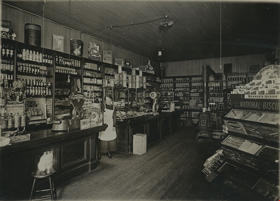
![Interior of a Kingsway Store, [190-] (date of original), copied 1976 thumbnail](/media/hpo/_Data/_BVM_Images/1976/1976_0153_0001_001.jpg?width=280)
Interior of a Kingsway Store
https://search.heritageburnaby.ca/link/museumdescription842
- Repository
- Burnaby Village Museum
- Date
- [190-] (date of original), copied 1976
- Collection/Fonds
- Burnaby Village Museum Photograph collection
- Description Level
- Item
- Physical Description
- 1 photograph : b&w ; 11.5 x 16.5 cm, mounted on card 17.5 x 22.5 cm
- Scope and Content
- Photograph of the interior of what has been identified by the accession register as a Kingsway Store. Inside the store, there is a woman wearing an apron standing by the counters who has been identified as Mrs. C.B. Button. Behind the counter, a large cash register can be seen. There are weights…
- Repository
- Burnaby Village Museum
- Collection/Fonds
- Burnaby Village Museum Photograph collection
- Description Level
- Item
- Physical Description
- 1 photograph : b&w ; 11.5 x 16.5 cm, mounted on card 17.5 x 22.5 cm
- Scope and Content
- Photograph of the interior of what has been identified by the accession register as a Kingsway Store. Inside the store, there is a woman wearing an apron standing by the counters who has been identified as Mrs. C.B. Button. Behind the counter, a large cash register can be seen. There are weights, various tin cans, Rennie's seeds, Christie's biscuits, etc. on display. There is a cat sitting on a stool in front of the counter. The interior has hardwood finishing on the floor, walls and ceiling.
- Geographic Access
- Kingsway
- Nelson Avenue
- Street Address
- 4920 Kingsway
- Accession Code
- HV976.153.1
- Access Restriction
- No restrictions
- Reproduction Restriction
- May be restricted by third party rights
- Date
- [190-] (date of original), copied 1976
- Media Type
- Photograph
- Historic Neighbourhood
- Central Park (Historic Neighbourhood)
- Planning Study Area
- Marlborough Area
- Scan Resolution
- 600
- Scan Date
- 2023-06-27
- Notes
- Title based on contents of photograph
Images
![Interior of a Kingsway Store, [190-] (date of original), copied 1976 thumbnail](/media/hpo/_Data/_BVM_Images/1976/1976_0153_0001_001.jpg)
![James Smith house, [1907] thumbnail](/media/hpo/_Data/_Archives_Images/_Unrestricted/126/137-001.jpg?width=280)
James Smith house
https://search.heritageburnaby.ca/link/archivedescription34808
- Repository
- City of Burnaby Archives
- Date
- [1907]
- Collection/Fonds
- Burnaby Historical Society fonds
- Description Level
- Item
- Physical Description
- 1 photograph : b&w ; 10.0 x 14.0 cm mounted on 17.7 x 22.cm cardboard
- Scope and Content
- Photograph of the exterior of the James Smith house, 6186 Royal Oak Avenue. A woman and two girls are seated on the porch stairs. The accession description states that the house is a B.C. Mills Prefab erected in 1907 by Mr. and Mrs. Smith.
- Repository
- City of Burnaby Archives
- Date
- [1907]
- Collection/Fonds
- Burnaby Historical Society fonds
- Subseries
- Grace Pletcher subseries
- Physical Description
- 1 photograph : b&w ; 10.0 x 14.0 cm mounted on 17.7 x 22.cm cardboard
- Description Level
- Item
- Record No.
- 137-001
- Access Restriction
- No restrictions
- Reproduction Restriction
- No known restrictions
- Accession Number
- BHS1985-06
- Scope and Content
- Photograph of the exterior of the James Smith house, 6186 Royal Oak Avenue. A woman and two girls are seated on the porch stairs. The accession description states that the house is a B.C. Mills Prefab erected in 1907 by Mr. and Mrs. Smith.
- Subjects
- Buildings - Residential - Houses
- Media Type
- Photograph
- Notes
- Title based on contents of photograph
- Annotations on the back of the cardboard read, "With love from Agnes" and "Mrs H Rolfe / Charles Rd. / South Portland / Maine."
- Geographic Access
- Royal Oak Avenue
- Street Address
- 6186 Royal Oak Avenue
- Historic Neighbourhood
- Central Park (Historic Neighbourhood)
- Planning Study Area
- Windsor Area
Images
![James Smith house, [1907] thumbnail](/media/hpo/_Data/_Archives_Images/_Unrestricted/126/137-001.jpg)

Jubilee Methodist Church
https://search.heritageburnaby.ca/link/archivedescription36018
- Repository
- City of Burnaby Archives
- Date
- 1909
- Collection/Fonds
- Burnaby Historical Society fonds
- Description Level
- Item
- Physical Description
- 1 photograph : sepia postcard ; 8 x 13 cm
- Scope and Content
- Photographic postcard of the Jubilee Methodist Church.
- Repository
- City of Burnaby Archives
- Date
- 1909
- Collection/Fonds
- Burnaby Historical Society fonds
- Subseries
- Ephemera subseries
- Physical Description
- 1 photograph : sepia postcard ; 8 x 13 cm
- Description Level
- Item
- Record No.
- 212-001
- Access Restriction
- No restrictions
- Reproduction Restriction
- No known restrictions
- Accession Number
- BHS1988-12
- Scope and Content
- Photographic postcard of the Jubilee Methodist Church.
- Media Type
- Photograph
- Notes
- Title based on contents of photograph
- Geographic Access
- Sussex Avenue
- Street Address
- 6050 Sussex Avenue
- Historic Neighbourhood
- Central Park (Historic Neighbourhood)
- Planning Study Area
- Marlborough Area
Images
