Memorial cards for Martha Love
https://search.heritageburnaby.ca/link/museumdescription10093
- Repository
- Burnaby Village Museum
- Date
- 1920
- Collection/Fonds
- Love family fonds
- Description Level
- File
- Physical Description
- 1 folder of textual records
- Scope and Content
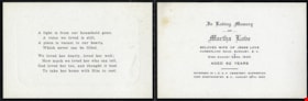
- File consists of a three memorial cards for Martha Love which read: "In Loving Memory / OF / Martha Love / BELOVED WIFE OF JESSE LOVE / CUMBERLAND ROAD, BURNABY, B.C. / Died August 24RD. 1920 / AGED 62 YEARS / INTERRED IN I.O.O.F. CEMETERY, SAPPERTON / NEW WESTMINSTER, B.C., AUGUST 26TH, 1920". A s…
- Repository
- Burnaby Village Museum
- Collection/Fonds
- Love family fonds
- Description Level
- File
- Physical Description
- 1 folder of textual records
- Scope and Content
- File consists of a three memorial cards for Martha Love which read: "In Loving Memory / OF / Martha Love / BELOVED WIFE OF JESSE LOVE / CUMBERLAND ROAD, BURNABY, B.C. / Died August 24RD. 1920 / AGED 62 YEARS / INTERRED IN I.O.O.F. CEMETERY, SAPPERTON / NEW WESTMINSTER, B.C., AUGUST 26TH, 1920". A short, religious poem is printed on the inside face of the card. "IN LOVING / MEMORY" with an image of a rose is printed on the front face of the card.
- History
- See extensive history of Love Family and Love farmhouse located at Burnaby Village Museum.
- Accession Code
- BV012.31.25
- Access Restriction
- No restrictions
- Reproduction Restriction
- No known restrictions
- Date
- 1920
- Media Type
- Textual Record
- Scan Resolution
- 600
- Scan Date
- 7-May-20
- Scale
- 100
- Notes
- Title based on content of file
Images

![Subdivision plans in New Westminster District Group 1 – Burnaby
, [1900-1910] thumbnail](/media/hpo/_Data/_BVM_Cartographic_Material/1977/1977_0093_0009a_001.jpg?width=280)
Subdivision plans in New Westminster District Group 1 – Burnaby
https://search.heritageburnaby.ca/link/museumdescription6978
- Repository
- Burnaby Village Museum
- Date
- [1900-1910]
- Collection/Fonds
- Burnaby Village Museum Map collection
- Description Level
- File
- Physical Description
- 4 plans : blueprint ink on paper mounted on 2 sides of cardboard 76 x 102 cm
- Scope and Content
- Item consists of a large board with two New Westminster District Gp 1 - subdivision plans mounted on one side and two New Westminster District Gp 1 - subdivision plans mounted on the other side. Side A: 1. Blueprint "Plan/ of Subdivisions / of portions / of / Lot 91, / Group 1 / New Westminster …
- Repository
- Burnaby Village Museum
- Collection/Fonds
- Burnaby Village Museum Map collection
- Description Level
- File
- Physical Description
- 4 plans : blueprint ink on paper mounted on 2 sides of cardboard 76 x 102 cm
- Material Details
- Scales [between 1:792 and 1:2376]
- Index number on edge of board reads: "9"
- Scope and Content
- Item consists of a large board with two New Westminster District Gp 1 - subdivision plans mounted on one side and two New Westminster District Gp 1 - subdivision plans mounted on the other side. Side A: 1. Blueprint "Plan/ of Subdivisions / of portions / of / Lot 91, / Group 1 / New Westminster Dist. / Scale 3 chs = 1 in / Map Nos 535 & 506". (Geographic location: Burnaby) 2. Blueprint "Plan / of / Subdivision of a Portion / of / Lot 28 / Group One / New Westminster Dist. / Scale 1 chs = 1 in / Map No 274". Lots are identified as "I / II / III / VI / V / IV ". The plan is bordered by First Avenue, Suburban Lands and Cemetery at the bottom, 13th Street at the top, Douglas Road to the west and 4th Street to the east. The plan is signed by "W. Thibaudeau". (Geographic location: Burnaby) Side B: 1. Blueprint "Plan / of the Subdivision of a Portion / of / Lot 29 / Group One / New Westminster District / Scale 1ch = 1 in / Map No 291 _ Subdivision 'L'". (Geographic location: Burnaby) 2. Blueprint " Plan of Subdivision / of / Lot 27 / Group One / New Westminster Dist. / Scale 3 chs = 1 in. / Map No. 697". (Geographic location: Burnaby)
- Accession Code
- HV977.93.9
- Access Restriction
- No restrictions
- Reproduction Restriction
- No known restrictions
- Date
- [1900-1910]
- Media Type
- Cartographic Material
- Scan Resolution
- 300
- Scale
- 72
- Notes
- Title based on contents of file
- Scale is measured in chains. (One chain equals 792 inches)
- The term "Lot" can also refer to a "District Lot”
Images
![Subdivision plans in New Westminster District Group 1 – Burnaby
, [1900-1910] thumbnail](/media/hpo/_Data/_BVM_Cartographic_Material/1977/1977_0093_0009a_001.jpg)
