Narrow Results By
Burnaby
https://search.heritageburnaby.ca/link/archivedescription65839
- Repository
- City of Burnaby Archives
- Date
- June 1977
- Collection/Fonds
- Burnaby Historical Society fonds
- Description Level
- Item
- Physical Description
- 1 map : col. ink on paper ; 77 x 55 cm folded to 28 x 19 cm
- Scope and Content
- Item is a map of Burnaby District Municipality, British Columbia, compiled by the Burnaby Planning Department. The map indicates locations of schools, parks, cemeteries, improved streets and private roads, etc.
- Repository
- City of Burnaby Archives
- Date
- June 1977
- Collection/Fonds
- Burnaby Historical Society fonds
- Subseries
- Municipal record subseries
- Physical Description
- 1 map : col. ink on paper ; 77 x 55 cm folded to 28 x 19 cm
- Material Details
- Scale : 1 cm = 1/8 of a mile
- Description Level
- Item
- Record No.
- 42694
- Accession Number
- BHS2007-04
- Scope and Content
- Item is a map of Burnaby District Municipality, British Columbia, compiled by the Burnaby Planning Department. The map indicates locations of schools, parks, cemeteries, improved streets and private roads, etc.
- Media Type
- Cartographic Material
Cemetery site - North Burnaby
https://search.heritageburnaby.ca/link/archivedescription910
- Repository
- City of Burnaby Archives
- Date
- 1913-1917
- Collection/Fonds
- City Council and Office of the City Clerk fonds
- Description Level
- File
- Physical Description
- Textual record and cartographic material
- Scope and Content
- File contains correspondence and reports pertaining to a proposed cemetery site in North Burnaby (DL 148). File also includes news clippings concerning same.
- Repository
- City of Burnaby Archives
- Date
- 1913-1917
- Collection/Fonds
- City Council and Office of the City Clerk fonds
- Physical Description
- Textual record and cartographic material
- Description Level
- File
- Record No.
- 2675
- Accession Number
- 2001-02
- Scope and Content
- File contains correspondence and reports pertaining to a proposed cemetery site in North Burnaby (DL 148). File also includes news clippings concerning same.
- Media Type
- Textual Record
- Cartographic Material
- Notes
- A "Map of Municipality of Burnaby, Aug. 21, 1913" and "Plan of Proposed Cemetery Site - Parts of DL 143 and 148" in map case.
postcard
https://search.heritageburnaby.ca/link/museumartifact48902
- Repository
- Burnaby Village Museum
- Accession Code
- BV005.74.1
- Description
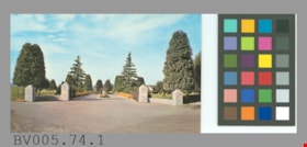
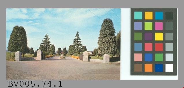
- Postcard, colour photo, glossy; horizontal; shows open gates at main entrance of cemetary, pillars, drive; trees, lawn, flowers visible beyond; on reverse in blue "OCEAN VIEW BURIAL PARK CO." "6790 Patterson Ave., S. Burnaby, B.C." "MAIN ENTRANCE" "Featuring some of the many pleasing floral displays which are established throughout the Cemetery. The entire Cemetery receives Endowed Care. Information supplied upon enquiry regarding prices of plots, cremation and mausoleum entombments."; at lower left, "Colour Photo by Dominion Photo Co., Vancouver, B.C."; up centre is "A Traveltime PRODUCT, MADE IN VANCOUVER, CANADA, BY GRANT-MANN LITHOGRAPHERS LTD."; at bottom, "C-478"; at upper right, "POST CARD" "ADDRESS", outline of rectangle "STAMP"; unused ; card is identical to BV005.74.2
- Object History
- This item was given to the donor when he was doing research for the Cemetery Tour, 2005.
- Classification
- Written Communication T&E - - Writing Media
- Object Term
- Postcard
- Marks/Labels
- Ocean View Burial Park Co. / 6790 Patterson Ave., S. Burnaby, BC / Main Entrance / featuring some of the many pleasing floral displays which are established throughout the cemetery
- Country Made
- Canada
- Province Made
- British Columbia
- Site/City Made
- Vancouver
- Title
- Ocean View Burial Park Co. C-478
- Names
- Dominion Photo Company
Images
Cemetery site (proposed) - Douglas Road and Edmonds Street
https://search.heritageburnaby.ca/link/archivedescription1067
- Repository
- City of Burnaby Archives
- Date
- 1916
- Collection/Fonds
- City Council and Office of the City Clerk fonds
- Description Level
- File
- Physical Description
- Textual record and cartographic material
- Scope and Content
- File contains correspondence and report on the proposal to create a cemetery site at Douglas Road and Edmonds Street. File also includes a linen plan of the area.
- Repository
- City of Burnaby Archives
- Date
- 1916
- Collection/Fonds
- City Council and Office of the City Clerk fonds
- Physical Description
- Textual record and cartographic material
- Description Level
- File
- Record No.
- 2854
- Accession Number
- 2001-02
- Scope and Content
- File contains correspondence and report on the proposal to create a cemetery site at Douglas Road and Edmonds Street. File also includes a linen plan of the area.
- Media Type
- Textual Record
- Cartographic Material
- Notes
- Plans/maps are located in file and have not been moved to map case.
postcard
https://search.heritageburnaby.ca/link/museumartifact45451
- Repository
- Burnaby Village Museum
- Accession Code
- BV003.26.3
- Description
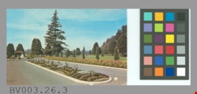
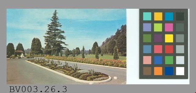
- Postcard, colour photo, glossy; horizontal; shows drive with flowerbeds, shrubs, trees, lawn behind, fountain; in blue on reverse, "OCEAN VIEW BURIAL PARK" "6790 Patterson Ave., S. Burnaby, B.C." "FLOWER BED -- MAIN ENTRANCE" "One of the many beautiful and unusual floral effects which is a feature throughout the entire Cemetery grounds."; at bottom left, "Colour Photo by Dominion Photo Co., Vancouver, B.C."; up centre, "A Traveltime PRODUCT, MADE IN VANCOUVER, CANADA, BY GRANT-MANN LITHOGRAPHERS LTD."; at bottom, "C-480"; at upper right, "POST CARD" "ADDRESS", outline of rectangle "STAMP"; unused; smudges on address side; one corner creased
- Object History
- Purchased from E-Bay, #2163154620.
- Classification
- Written Communication T&E - - Writing Media
- Object Term
- Postcard
- Country Made
- Canada
- Province Made
- British Columbia
- Site/City Made
- Vancouver
- Title
- Ocean View Burial Park C-480
- Names
- Dominion Photo Company
Images
postcard
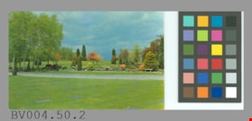
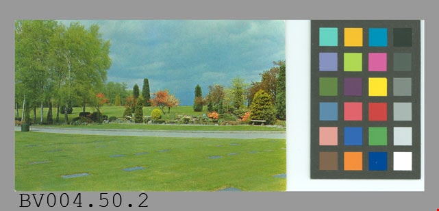
https://search.heritageburnaby.ca/link/museumartifact47196
- Repository
- Burnaby Village Museum
- Accession Code
- BV004.50.2
- Description
- Postcard: colour photo, glossy; horizontal; Forest Lawn cemetery; shows lawn, markers, path, trees, shrubs, flowers; on reverse, "Famous for the beauty and unusual design of its magnificent gardens Forest Lawn Memorial Park attracts thousands of visitors every year. It is located on the Grandview Highway at Royal Oak Avenue, only a few miles from downtown Vancouver, B.C."; at lower left, "Colour Photo by Dominion Photo Co."; up centre "A Traveltime PRODUCT, MADE IN VANCOUVER, CANADA, BY GRANT-MANN LITHOGRAPHERS LTD."; maple leaf logo at top "BUY CANADIAN"; at bottom "C-744"; at upper right, "POST CARD" "ADDRESS", outline of rectangle "STAMP"; unused; slight wear on corners
- Classification
- Written Communication T&E - - Writing Media
- Object Term
- Postcard
- Marks/Labels
- Forest Lawn Memorial Park / Grandview Highway / Royal Oak Avenue
- Country Made
- Canada
- Province Made
- British Columbia
- Site/City Made
- Vancouver
- Title
- Forest Lawn Memorial Park C-744
- Names
- Dominion Photo Company
Images
postcard
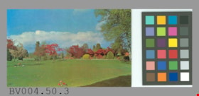
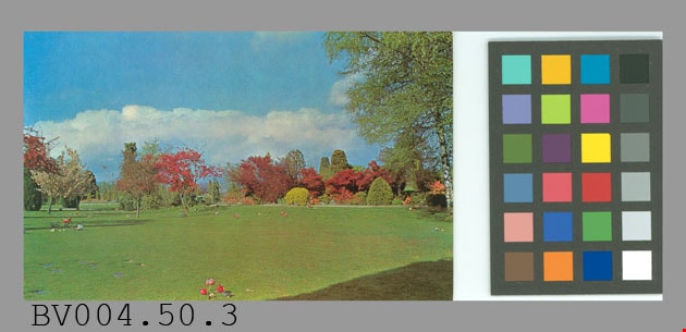
https://search.heritageburnaby.ca/link/museumartifact47197
- Repository
- Burnaby Village Museum
- Accession Code
- BV004.50.3
- Description
- Postcard, colour photo, glossy; horizontal; shows Forest Lawn cemetery, lawn with some markers visible, shrubs and trees in background; on reverse in blue, "Famous for the beauty and unusual design of its magnificent gardens, Forest Lawn Memorial Park attracts thousands of visitors every year. It is located on the Grandview Highway at Royal Oak Avenue, only a few miles from downtown Vancouver, B.C."; at bottom left, "Colour Photo by Dominion Photo Co."; up centre, "A Traveltime PRODUCT, MADE IN VANCOUVER, CANADA, BY GRANT-MANN LITHOGRAPHERS LTD."; maple leaf logo at top "BUY CANADIAN"; at bottom, "C-747"; at upper right, "POST CARD", with "ADDRESS" below; outline of rectangle at upper right corner, "STAMP"; some yellowish stains; corners are worn; creasing at top centre and wear; unused
- Classification
- Written Communication T&E - - Writing Media
- Object Term
- Postcard
- Marks/Labels
- Forest Lawn Memorial Park / Grandview Highway / Royal Oak Avenue
- Country Made
- Canada
- Province Made
- British Columbia
- Site/City Made
- Vancouver
- Title
- Famous for the beauty... Forest Lawn Memorial Park... C-747
- Names
- Dominion Photo Company
Images
postcard
https://search.heritageburnaby.ca/link/museumartifact48617
- Repository
- Burnaby Village Museum
- Accession Code
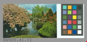
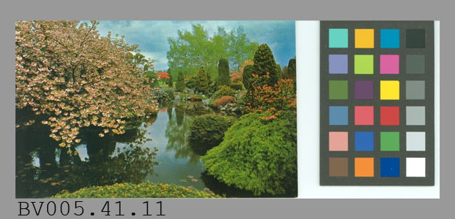
- BV005.41.11
- Description
- Postcard: colour photo, glossy; horizontal; Forest Lawn cemetery; shows flowering tree and shrubs, trees around lake; on reverse in blue, "Famous for the beauty and design of its magnificent rock gardens and its lovely ornamental trees, Forest Lawn Memorial Park is located on the Grandview Highway at Royal Oak Avenue, Vancouver, B.C."; at bottom left, "Colour Photo by Dominion Photo Co."; up centre, "A Traveltime PRODUCT, MADE IN VANCOUVER, CANADA, BY GRANT-MANN LITHOGRAPHERS LTD."; maple leaf logo at top "BUY CANADIAN"; at bottom, "C-745"; at upper right, "POST CARD" "ADDRESS"; outline of rectangle "STAMP"; unused; very slight wear on corners
- Classification
- Written Communication T&E - - Writing Media
- Object Term
- Postcard
- Marks/Labels
- Forest Lawn / Memorial Park is located on the Grandview Highway at / Royal Oak Avenue, Vancouver, B.C. / C745
- Country Made
- Canada
- Province Made
- British Columbia
- Site/City Made
- Vancouver
- Title
- Forest Lawn Memorial Park C-745
- Names
- Dominion Photo Company
Images
![Subdivision plans in New Westminster District Group 1 – Burnaby
, [1900-1910] thumbnail](/media/hpo/_Data/_BVM_Cartographic_Material/1977/1977_0093_0009a_001.jpg?width=280)
Subdivision plans in New Westminster District Group 1 – Burnaby
https://search.heritageburnaby.ca/link/museumdescription6978
- Repository
- Burnaby Village Museum
- Date
- [1900-1910]
- Collection/Fonds
- Burnaby Village Museum Map collection
- Description Level
- File
- Physical Description
- 4 plans : blueprint ink on paper mounted on 2 sides of cardboard 76 x 102 cm
- Scope and Content
- Item consists of a large board with two New Westminster District Gp 1 - subdivision plans mounted on one side and two New Westminster District Gp 1 - subdivision plans mounted on the other side. Side A: 1. Blueprint "Plan/ of Subdivisions / of portions / of / Lot 91, / Group 1 / New Westminster …
- Repository
- Burnaby Village Museum
- Collection/Fonds
- Burnaby Village Museum Map collection
- Description Level
- File
- Physical Description
- 4 plans : blueprint ink on paper mounted on 2 sides of cardboard 76 x 102 cm
- Material Details
- Scales [between 1:792 and 1:2376]
- Index number on edge of board reads: "9"
- Scope and Content
- Item consists of a large board with two New Westminster District Gp 1 - subdivision plans mounted on one side and two New Westminster District Gp 1 - subdivision plans mounted on the other side. Side A: 1. Blueprint "Plan/ of Subdivisions / of portions / of / Lot 91, / Group 1 / New Westminster Dist. / Scale 3 chs = 1 in / Map Nos 535 & 506". (Geographic location: Burnaby) 2. Blueprint "Plan / of / Subdivision of a Portion / of / Lot 28 / Group One / New Westminster Dist. / Scale 1 chs = 1 in / Map No 274". Lots are identified as "I / II / III / VI / V / IV ". The plan is bordered by First Avenue, Suburban Lands and Cemetery at the bottom, 13th Street at the top, Douglas Road to the west and 4th Street to the east. The plan is signed by "W. Thibaudeau". (Geographic location: Burnaby) Side B: 1. Blueprint "Plan / of the Subdivision of a Portion / of / Lot 29 / Group One / New Westminster District / Scale 1ch = 1 in / Map No 291 _ Subdivision 'L'". (Geographic location: Burnaby) 2. Blueprint " Plan of Subdivision / of / Lot 27 / Group One / New Westminster Dist. / Scale 3 chs = 1 in. / Map No. 697". (Geographic location: Burnaby)
- Accession Code
- HV977.93.9
- Access Restriction
- No restrictions
- Reproduction Restriction
- No known restrictions
- Date
- [1900-1910]
- Media Type
- Cartographic Material
- Scan Resolution
- 300
- Scale
- 72
- Notes
- Title based on contents of file
- Scale is measured in chains. (One chain equals 792 inches)
- The term "Lot" can also refer to a "District Lot”
Images
![Subdivision plans in New Westminster District Group 1 – Burnaby
, [1900-1910] thumbnail](/media/hpo/_Data/_BVM_Cartographic_Material/1977/1977_0093_0009a_001.jpg)
