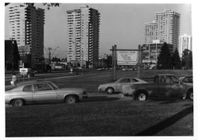
Highrises at Central Park
https://search.heritageburnaby.ca/link/archivedescription93690
- Repository
- City of Burnaby Archives
- Date
- June 4, 1978
- Collection/Fonds
- Burnaby Public Library Contemporary Visual Archive Project
- Description Level
- Item
- Physical Description
- 1 photograph : b&w ; 12.5 x 17.5 cm
- Scope and Content
- Photograph of high-rise apartment buildings next to Central Park. One of the apartments has a sign that reads "Central Park Place." A sign for Central Park is in the foreground on the edge of a grassy lawn and gravel road, where cars are parked. The photograph is taken facing east.
- Repository
- City of Burnaby Archives
- Date
- June 4, 1978
- Collection/Fonds
- Burnaby Public Library Contemporary Visual Archive Project
- Physical Description
- 1 photograph : b&w ; 12.5 x 17.5 cm
- Description Level
- Item
- Record No.
- 556-647
- Access Restriction
- No restrictions
- Reproduction Restriction
- Reproduce for fair dealing purposes only
- Accession Number
- 2017-57
- Scope and Content
- Photograph of high-rise apartment buildings next to Central Park. One of the apartments has a sign that reads "Central Park Place." A sign for Central Park is in the foreground on the edge of a grassy lawn and gravel road, where cars are parked. The photograph is taken facing east.
- Media Type
- Photograph
- Photographer
- Chapman, Fred
- Notes
- Title taken from project information form
- Accompanied by a project information form and 1 photograph (b&w negative ; 9.5 x 12.5 cm)
- BPL no. 95
- Geographic Access
- Central Park
- Patterson Avenue
- Kingsway
- Historic Neighbourhood
- Central Park (Historic Neighbourhood)
- Planning Study Area
- Cascade-Schou Area
Images
N.E. Corner Boundry [sic] Rd / CA Way
https://search.heritageburnaby.ca/link/archivedescription93759
- Repository
- City of Burnaby Archives
- Date
- May 27, 1992
- Collection/Fonds
- Grover, Elliott & Co. Ltd. fonds
- Description Level
- File
- Physical Description
- 25 photographs : col. negatives ; 35 mm
- Scope and Content
- Photographs of an undeveloped property located on the northeast corner of Boundary Road and Canada Way.
- Repository
- City of Burnaby Archives
- Date
- May 27, 1992
- Collection/Fonds
- Grover, Elliott & Co. Ltd. fonds
- Physical Description
- 25 photographs : col. negatives ; 35 mm
- Description Level
- File
- Record No.
- 622-044
- Access Restriction
- No restrictions
- Reproduction Restriction
- No restrictions
- Accession Number
- 2017-39
- Scope and Content
- Photographs of an undeveloped property located on the northeast corner of Boundary Road and Canada Way.
- Subjects
- Buildings - Residential - Houses
- Media Type
- Photograph
- Photographer
- Cameron, James
- Notes
- Transcribed title
- Title transcribed from envelope photographs were originally housed in
- File no. 92-189-B
- Geographic Access
- Boundary Road
- Canada Way
- Historic Neighbourhood
- Broadview (Historic Neighbourhood)
- Planning Study Area
- Cascade-Schou Area
