Narrow Results By
map
https://search.heritageburnaby.ca/link/museumartifact83653
- Repository
- Burnaby Village Museum
- Accession Code
- BV007.34.1
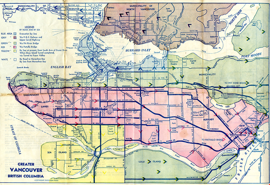
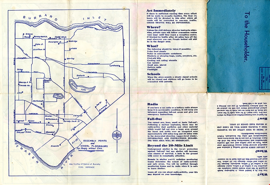
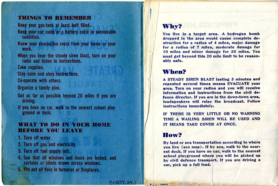
- Description
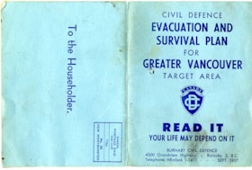
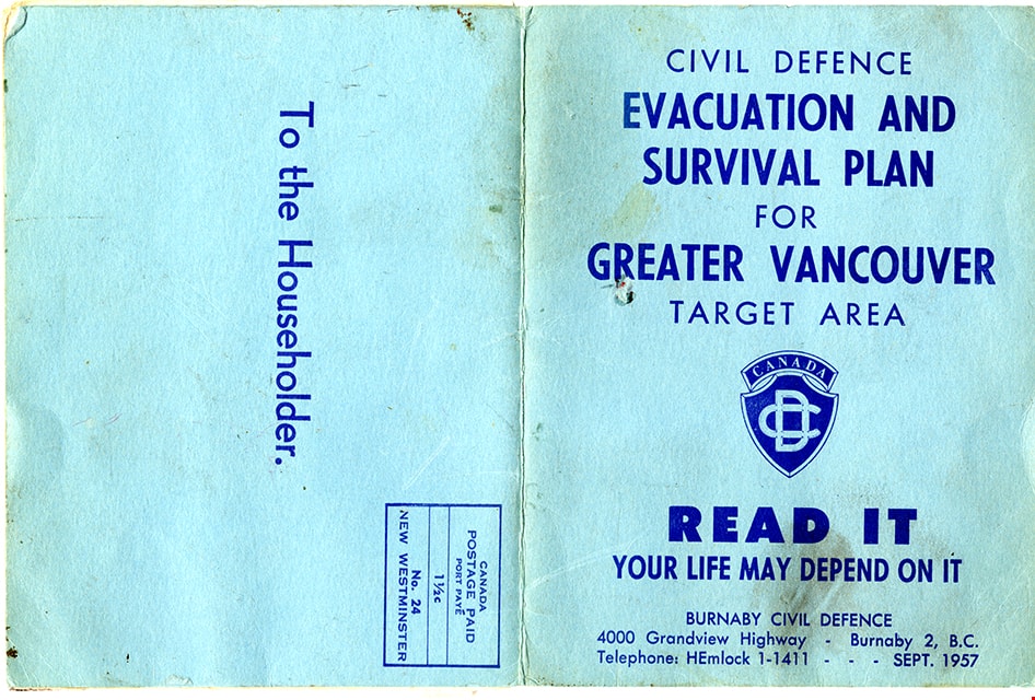
- Folded col. map within blue cover; printed both sides; Civil Defence Evacuation and Survival Plan - Map -- [1957] produced by Burnaby Civil Defence; title on front cover reads "CIVIL DEFENCE / EVACUATION AND SURVIVAL PLAN /FOR / GREATER VANCOUVER / TARGET AREA / READ IT / YOUR LIFE MAY DEPEND ON IT". Colour map inside is titled "GREATER / VANCOUVER / BRITISH COLUMBIA" and includes a legend with various evacuation routes by road and by sea; copyright Evergreen Press. Verso of map includes a map of Burnaby courtesy of District of Burnaby Civil Defence titled "ASSEMBLY POINTS / and / SCHOOL PLAYGROUNDS / for People without Cars" and detailed information about things to remember during an emergency evacuation.
- Object History
- Map was made available to citizens of Burnaby and was produced by Burnaby Civil Defence, 4000 Grandview Highway, Burnaby B.C.
- Category
- 08. Communication Artifacts
- Classification
- Documentary Artifacts - - Graphic Documents
- Object Term
- Cartograph, Map
- Colour
- Blue
- Measurements
- 30.5 x 34 cm folded to 15 x 11.5 cm
- Maker
- Evergreen Press Limited
- Country Made
- Canada
- Province Made
- British Columbia
- Publication Date
- Sept. 1957
- Names
- Burnaby Civil Defence
Images
map
https://search.heritageburnaby.ca/link/museumartifact87474
- Repository
- Burnaby Village Museum
- Accession Code
- BV015.35.83
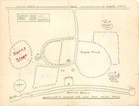
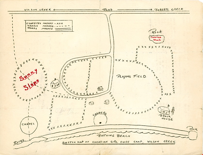
- Description
- map; "SKETCH MAP OF CANADIAN GIRL GUIDE CAMP, WILSON CREEK"; hand-drawn map shows locations of campsites, trails, roads, bathing beach, chapel, playing field, etc.; back of map has text in brown ink reading: "Over the hill and / down the valley" and Over the ill & do"
- Object History
- Map belonged to Dorothy Pitman who was a Girl Guide in the 1st Burnaby Company. She was known to be involved with guiding from 1919 to 1931. Textual records and photographs of the Pitman family, including one of Dorothy and her sister Gwen, are held by the City of Burnaby Archives. Dorothy and Gwen's parents, Ernest and Jean Pitman, owned McKay Dry Goods and Jubilee Dry Goods.
- Category
- 08. Communication Artifacts
- Classification
- Documentary Artifacts - - Graphic Documents
- Object Term
- Cartograph, Map
Images
Map
https://search.heritageburnaby.ca/link/museumartifact90944
- Repository
- Burnaby Village Museum
- Accession Code
- BV021.4.30
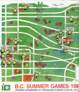
- Description
- BC Summer Games Cartoon Map of Burnaby. Location of sporting events are labeled with cartoon bees holding signs with flowers. BC Games logo is in the bottom right, with "B.C. SUMMER GAMES 1984 BURNABY B.C./ Opening Ceremonies at Swangaurd Stadium, 6:30 P.M. July 19th...Come Out and Join the the Fun!"
- Object History
- Item pertaining to BC Summer Games which took place in Burnaby July 19-22, 1984.
- Category
- 08. Communication Artifacts
- Classification
- Documentary Artifacts - - Graphic Documents
- Object Term
- Cartograph, Map
- Colour
- White
- Green
- Measurements
- 25 cm high x 35 cm wide
- Subjects
- Sports
- Recreational Activities
Images


map
https://search.heritageburnaby.ca/link/museumartifact91044
- Repository
- Burnaby Village Museum
- Accession Code
- BV020.5.1769
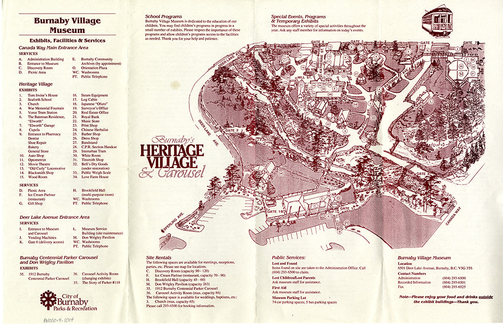
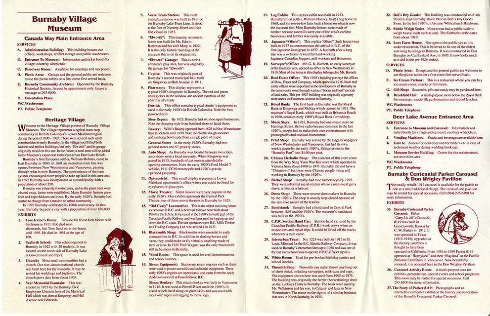
- Description
- Map; site Map printed on beige paper with burgundy ink; four section accordian fold; front includes site Map of Burnaby Village Museum with title "Burnaby's / HERITAGE / VILLAGE / & Carousel"; lists exhibits, facilities and services; back of Map includes detailed descriptions of services and exhibits along with three in line illustrations.
- Object History
- Item was found in Burnaby Village Museum printshop along with other Heritage Village / Burnaby Village Museum ephemera created between 1971 and 1990
- Category
- 08. Communication Artifacts
- Classification
- Documentary Artifacts - - Other Documents
- Object Term
- Cartograph, Map
- Measurements
- 28 x 43 cm
- Country Made
- Canada
- Province Made
- British Columbia
- Publication Date
- [1994]
- Subjects
- Documentary Artifacts
- Names
- Burnaby Village Museum
Images
map
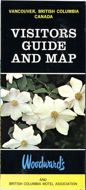
https://search.heritageburnaby.ca/link/museumartifact91126
- Repository
- Burnaby Village Museum
- Accession Code
- BV011.44.10
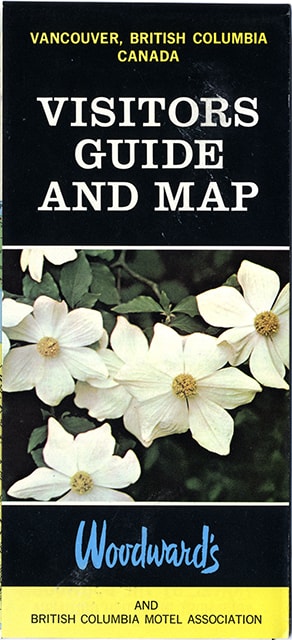
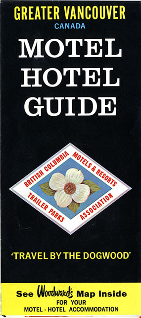
- Description
- map brochure; cover on one side reads "VANCOUVER, BRITISH COLUMBIA / CANADA / VISITORS / GUIDE / AND MAP" and the other side reads: "GREATER VANCOUVER / CANADA / MOTEL / HOTEL / GUIDE / TRAVEL BY THE DOGOOD'" and includes the logo for "British Columbia / Motels & Resorts / Trailer Parks / Association" with dogwood in centre. One side of fold-out includes map titled "Guide Map of Greater Vancouver / Woodwards" and includes inset map of Downtown Vancouver and Stanley Park and inset map of Lower Mainland and Fraser Valley Vancouver and Vicinity along with a list of Greater Vanouver Area Motels and Hotels. The other side of the fold-out includes colour adds for tourist sites and amenities in Greater Vancouver including Capilano Suspension bridge; Heritage Village, Burnaby, B.C.; MacMillan Planetarium; Bloedel Conservatory; Grouse Mountain; Gastown; The Ship of the Seven Seas restaurant and Woodwards stores and shopping centres. Map was published in the public interest by Woodward's (Lower Mainland) department stores; B.C. Motels and Resorts Association Branch "C" whose members appear on the map inside.
- Category
- 08. Communication Artifacts
- Classification
- Documentary Artifacts - - Graphic Documents
- Object Term
- Cartograph, Map
- Measurements
- 45.5 x 70 cm folded to 22.5 x 10 cm
- Country Made
- Canada
- Geographic Access
- Vancouver
Images