Narrow Results By
Subject
- Animals - Poultry 1
- Buildings - Heritage 3
- Buildings - Residential - Houses 7
- Buildings - Schools 3
- Businesses - Real Estate Agencies 1
- Documentary Artifacts - Postcards 1
- Geographic Features - Roads 3
- Land Clearing 1
- Musical Instruments 2
- Natural Phenomena - Snow 2
- Occupations - Teachers 1
- Organizations - Boys' Societies and Clubs 1
Person / Organization
- Armstrong Avenue School 5
- Barnes, Hannah Victoria "Girlie" Love 7
- Boy Scouts of Canada 1
- Brandrith, Benjamin Jefferson "Ben" 3
- Brandrith, Martha Dorothy “Dot” Love 10
- British Columbia Electric Railway Company 1
- Burnett, Geoffrey K. 2
- Clayton, Edith Annie Whiting 2
- Deacon, Charles 2
- Feedham, Phoebe Leonard Love 1
- Great Northern Railway 3
- Guppy, Jack 2
Love family home
https://search.heritageburnaby.ca/link/archivedescription35723
- Repository
- City of Burnaby Archives
- Date
- 1918 (date of original), copied 1986
- Collection/Fonds
- Burnaby Historical Society fonds
- Description Level
- Item
- Physical Description
- 1 photograph : b&w ; 12.7 x 17.8 cm print
- Scope and Content
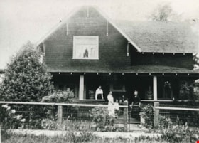
- Photograph of the Love family home at 1390 Cumberland Road (later renumbered 7651 Cumberland Street), East Burnaby. Identified: (right) Mrs. Martha Love (mother). In 1988, this house was moved to the site of the Burnaby Village Museum at Deer Lake Avenue, where it remains today.
- Repository
- City of Burnaby Archives
- Date
- 1918 (date of original), copied 1986
- Collection/Fonds
- Burnaby Historical Society fonds
- Subseries
- Pioneer Tales subseries
- Physical Description
- 1 photograph : b&w ; 12.7 x 17.8 cm print
- Description Level
- Item
- Record No.
- 204-581
- Access Restriction
- No restrictions
- Reproduction Restriction
- No known restrictions
- Accession Number
- BHS1988-03
- Scope and Content
- Photograph of the Love family home at 1390 Cumberland Road (later renumbered 7651 Cumberland Street), East Burnaby. Identified: (right) Mrs. Martha Love (mother). In 1988, this house was moved to the site of the Burnaby Village Museum at Deer Lake Avenue, where it remains today.
- Subjects
- Buildings - Residential - Houses
- Media Type
- Photograph
- Notes
- Title based on contents of photograph
- Geographic Access
- Cumberland Street
- Street Address
- 6501 Deer Lake Avenue
- Historic Neighbourhood
- East Burnaby (Historic Neighbourhood)
- Planning Study Area
- Cariboo-Armstrong Area
Images

Jesse and Martha Love
https://search.heritageburnaby.ca/link/archivedescription35724
- Repository
- City of Burnaby Archives
- Date
- 1918 (date of original), copied 1986
- Collection/Fonds
- Burnaby Historical Society fonds
- Description Level
- Item
- Physical Description
- 1 photograph : b&w ; 12.7 x 17.8 cm print
- Scope and Content
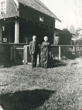
- Photograph of (left to right) Jesse Love (father) and Martha Love (mother) at their family home at 1390 Cumberland Road (later renumbered 7651 Cumberland Street), East Burnaby. In 1988, this house was moved to the site of the Burnaby Village Museum at Deer Lake Avenue, where it remains today.
- Repository
- City of Burnaby Archives
- Date
- 1918 (date of original), copied 1986
- Collection/Fonds
- Burnaby Historical Society fonds
- Subseries
- Pioneer Tales subseries
- Physical Description
- 1 photograph : b&w ; 12.7 x 17.8 cm print
- Description Level
- Item
- Record No.
- 204-582
- Access Restriction
- No restrictions
- Reproduction Restriction
- No known restrictions
- Accession Number
- BHS1988-03
- Scope and Content
- Photograph of (left to right) Jesse Love (father) and Martha Love (mother) at their family home at 1390 Cumberland Road (later renumbered 7651 Cumberland Street), East Burnaby. In 1988, this house was moved to the site of the Burnaby Village Museum at Deer Lake Avenue, where it remains today.
- Media Type
- Photograph
- Notes
- Title based on contents of photograph
- Geographic Access
- Cumberland Street
- Street Address
- 6501 Deer Lake Avenue
- Historic Neighbourhood
- East Burnaby (Historic Neighbourhood)
- Planning Study Area
- Cariboo-Armstrong Area
Images
![Martha and Jessie Love, [1918] thumbnail](/media/hpo/_Data/_Archives_Images/_Unrestricted/205/232-001.jpg?width=280)
Martha and Jessie Love
https://search.heritageburnaby.ca/link/archivedescription36204
- Repository
- City of Burnaby Archives
- Date
- [1918]
- Collection/Fonds
- Burnaby Historical Society fonds
- Description Level
- Item
- Physical Description
- 1 photograph : b&w ; 12.5 x 9 cm print
- Scope and Content
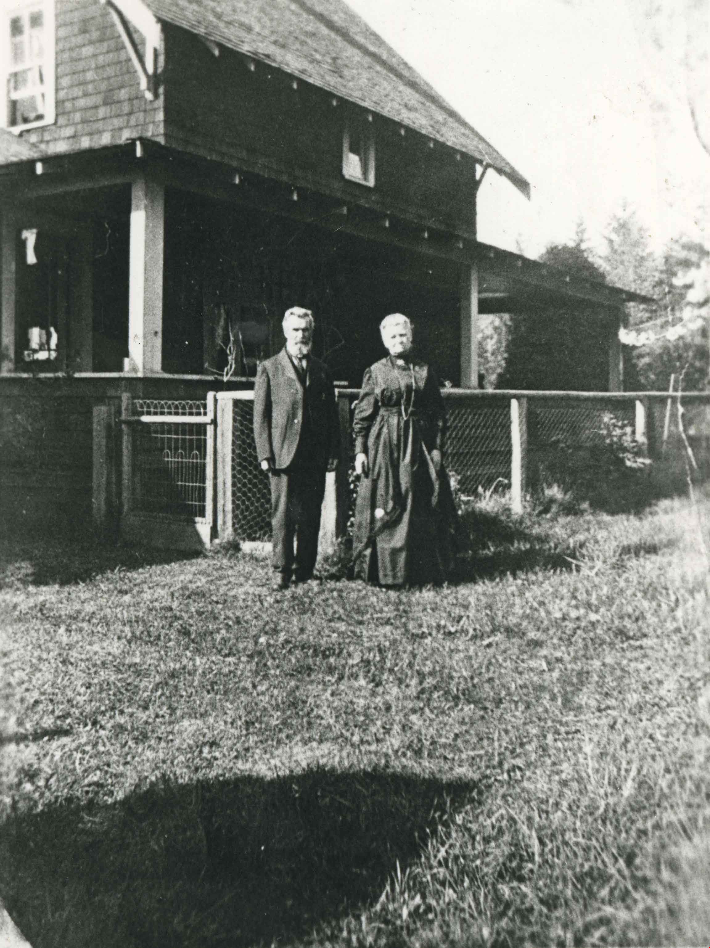
- Photograph of Martha and Jessie Love standing in their yard with blooming trees visible in the background.
- Repository
- City of Burnaby Archives
- Date
- [1918]
- Collection/Fonds
- Burnaby Historical Society fonds
- Subseries
- Love family subseries
- Physical Description
- 1 photograph : b&w ; 12.5 x 9 cm print
- Description Level
- Item
- Record No.
- 232-001
- Access Restriction
- No restrictions
- Reproduction Restriction
- No known restrictions
- Accession Number
- BHS1989-24
- Scope and Content
- Photograph of Martha and Jessie Love standing in their yard with blooming trees visible in the background.
- Media Type
- Photograph
- Notes
- Title based on contents of photograph
- 1 b&w copy negative accompanying
- Geographic Access
- Cumberland Street
- Street Address
- 6501 Deer Lake Avenue
- Historic Neighbourhood
- East Burnaby (Historic Neighbourhood)
- Planning Study Area
- Cariboo-Armstrong Area
Images
![Martha and Jessie Love, [1918] thumbnail](/media/hpo/_Data/_Archives_Images/_Unrestricted/205/232-001.jpg)
![Love farmhouse swing, [ca. 1918] (date of original), copied 1989 thumbnail](/media/hpo/_Data/_BVM_Images/2018/2018_0041_0192_001.jpg?width=280)
Love farmhouse swing
https://search.heritageburnaby.ca/link/museumdescription10012
- Repository
- Burnaby Village Museum
- Date
- [ca. 1918] (date of original), copied 1989
- Collection/Fonds
- Burnaby Village Museum fonds
- Description Level
- Item
- Physical Description
- 1 photograph : b&w negative ; 35 mm
- Scope and Content
- Photograph of an an unidentified woman sitting on a large wood framed swing with a group of unidentified children sitting at her feet.The swing is in the yard of the Love farmhouse. There is a tall tree to the right and several trees in the background, the ground is covered in tall grass.
- Repository
- Burnaby Village Museum
- Collection/Fonds
- Burnaby Village Museum fonds
- Series
- Jesse Love farmhouse series
- Subseries
- Love family photographs subseries
- Description Level
- Item
- Physical Description
- 1 photograph : b&w negative ; 35 mm
- Scope and Content
- Photograph of an an unidentified woman sitting on a large wood framed swing with a group of unidentified children sitting at her feet.The swing is in the yard of the Love farmhouse. There is a tall tree to the right and several trees in the background, the ground is covered in tall grass.
- Geographic Access
- Cumberland Street
- Street Address
- 7651 Cumberland Street
- Accession Code
- BV018.41.192
- Access Restriction
- No restrictions
- Reproduction Restriction
- May be restricted by third party rights
- Date
- [ca. 1918] (date of original), copied 1989
- Media Type
- Photograph
- Historic Neighbourhood
- East Burnaby (Historic Neighbourhood)
- Planning Study Area
- Cariboo-Armstrong Area
- Scan Resolution
- 2400
- Scan Date
- 4-Mar-2019
- Scale
- 100
- Notes
- Title based on contents of photograph
- 1 b&w copy print accompanying
Images
![Love farmhouse swing, [ca. 1918] (date of original), copied 1989 thumbnail](/media/hpo/_Data/_BVM_Images/2018/2018_0041_0192_001.jpg)
![John Leonard Love in uniform, [ca. 1915] (date of original), copied [2016] thumbnail](/media/hpo/_Data/_BVM_Images/2015/2015_0040_0045.jpg?width=280)
John Leonard Love in uniform
https://search.heritageburnaby.ca/link/museumdescription9998
- Repository
- Burnaby Village Museum
- Date
- [ca. 1915] (date of original), copied [2016]
- Collection/Fonds
- Esther Love Stanley fonds
- Description Level
- Item
- Physical Description
- 1 photograph (jpg)
- Scope and Content
- Photograph of John Leonard Love wearing a boy scout uniform and standing in front of a cherry tree in an orchard which may be on the grounds of the Love farmhouse.
- Repository
- Burnaby Village Museum
- Collection/Fonds
- Esther Love Stanley fonds
- Description Level
- Item
- Physical Description
- 1 photograph (jpg)
- Scope and Content
- Photograph of John Leonard Love wearing a boy scout uniform and standing in front of a cherry tree in an orchard which may be on the grounds of the Love farmhouse.
- Geographic Access
- Cumberland Street
- Street Address
- 7651 Cumberland Street
- Accession Code
- BV015.40.45
- Access Restriction
- No restrictions
- Reproduction Restriction
- No known restrictions
- Date
- [ca. 1915] (date of original), copied [2016]
- Media Type
- Photograph
- Historic Neighbourhood
- East Burnaby (Historic Neighbourhood)
- Planning Study Area
- Cariboo-Armstrong Area
- Scan Resolution
- 300
- Scan Date
- 09-Sep-18
- Notes
- Title based on annotations on digital file name
- Digital image created from orginal photograph by donor
Images
![John Leonard Love in uniform, [ca. 1915] (date of original), copied [2016] thumbnail](/media/hpo/_Data/_BVM_Images/2015/2015_0040_0045.jpg)

Armstrong Street School site
https://search.heritageburnaby.ca/link/museumdescription11133
- Repository
- Burnaby Village Museum
- Date
- 1915
- Collection/Fonds
- Ronald G. Scobbie collection
- Description Level
- Item
- Physical Description
- 1 survey plan : blueprint on paper ; 56 x 54 cm
- Scope and Content
- Survey plan of "Armstrong Street School Site / Burnaby Municipality" "Being a 2 acre portion of Lot 13 Group 1, & according to map 1722 which shows this as Lot E. Block 2 of subdivision of a portion, of Lot 13, Group 1, New Westminster District".
- Repository
- Burnaby Village Museum
- Collection/Fonds
- Ronald G. Scobbie collection
- Description Level
- Item
- Physical Description
- 1 survey plan : blueprint on paper ; 56 x 54 cm
- Material Details
- Scale 40 feet = 1 inch
- Scope and Content
- Survey plan of "Armstrong Street School Site / Burnaby Municipality" "Being a 2 acre portion of Lot 13 Group 1, & according to map 1722 which shows this as Lot E. Block 2 of subdivision of a portion, of Lot 13, Group 1, New Westminster District".
- Creator
- Burnett, Geoffrey K.
- Subjects
- Buildings - Schools
- Names
- Armstrong Avenue School
- Responsibility
- Burnett & McGugan, Engineers and Surveyors
- Geographic Access
- Armstrong Avenue
- Street Address
- 8757 Armstrong Avenue
- Accession Code
- BV003.83.12
- Access Restriction
- No restrictions
- Reproduction Restriction
- No known restrictions
- Date
- 1915
- Media Type
- Cartographic Material
- Historic Neighbourhood
- East Burnaby (Historic Neighbourhood)
- Planning Study Area
- Cariboo-Armstrong Area
- Scan Resolution
- 440
- Scan Date
- 22-Dec-2020
- Scale
- 100
- Notes
- Title based on contents of plan
- Note in black ink on verso of plan reads: "1746"
- Oath on plan reads: "I, Geoffrey K. Burnett...and did personally superintend the survey represented..." "Completed on the 18th day of March 1915"; signed by Geoffrey K. Burnett and notarized by "K.A. Eastman", sworn "...19th day of April 1915"; "Burnett and McGugan., B.C. Land Surveyors. Etc.. New Westminster, B.C.."
Zoomable Images

![Railway embankment, [1914] thumbnail](/media/hpo/_Data/_BVM_Images/1971/197200110004.jpg?width=280)
Railway embankment
https://search.heritageburnaby.ca/link/museumdescription1057
- Repository
- Burnaby Village Museum
- Date
- [1914]
- Collection/Fonds
- Burnaby Village Museum Photograph collection
- Description Level
- Item
- Physical Description
- 1 photograph : b&w glass negative ; 14.8 x 19.7 cm
- Scope and Content
- Photograph of a railway embankment. The railway is winding out of the picture frame with the road lined with electric posts running almost parallel to the rail tracks. An earlier catalogue record from 1988 notes that this is the view of the Great Northern Railway and cut along North Road just nort…
- Repository
- Burnaby Village Museum
- Collection/Fonds
- Burnaby Village Museum Photograph collection
- Description Level
- Item
- Physical Description
- 1 photograph : b&w glass negative ; 14.8 x 19.7 cm
- Scope and Content
- Photograph of a railway embankment. The railway is winding out of the picture frame with the road lined with electric posts running almost parallel to the rail tracks. An earlier catalogue record from 1988 notes that this is the view of the Great Northern Railway and cut along North Road just north of the Brunette River, looking southeast toward Coquitlam from Burnaby.
- Subjects
- Transportation - Rail
- Names
- Great Northern Railway
- Geographic Access
- North Road
- Accession Code
- HV972.11.4
- Access Restriction
- No restrictions
- Reproduction Restriction
- No known restrictions
- Date
- [1914]
- Media Type
- Photograph
- Planning Study Area
- Cariboo-Armstrong Area
- Related Material
- for another view of the same railway embankment, see HV972.11.2
- Scan Resolution
- 300
- Scan Date
- 14/8/2006
- Scale
- 100
- Notes
- Title based on contents of photograph
- 1 b&w contact print accompanying negative
Images
![Railway embankment, [1914] thumbnail](/media/hpo/_Data/_BVM_Images/1971/197200110004.jpg)
![Railway embankment, [1914] thumbnail](/media/hpo/_Data/_BVM_Images/1971/197200110002.jpg?width=280)
Railway embankment
https://search.heritageburnaby.ca/link/museumdescription3089
- Repository
- Burnaby Village Museum
- Date
- [1914]
- Collection/Fonds
- Burnaby Village Museum Photograph collection
- Description Level
- Item
- Physical Description
- 1 photograph : b&w glass negative ; 14.8 x 20.1 cm
- Scope and Content
- Photograph of a railway embankment. In the foreground is the railway, and in the midground a steep bluff, on top of which an unidentified man in a suit and a bowler hat is standing. There appears to be a road lined with electric posts close to where the man stands. An earlier catalogue record from…
- Repository
- Burnaby Village Museum
- Collection/Fonds
- Burnaby Village Museum Photograph collection
- Description Level
- Item
- Physical Description
- 1 photograph : b&w glass negative ; 14.8 x 20.1 cm
- Scope and Content
- Photograph of a railway embankment. In the foreground is the railway, and in the midground a steep bluff, on top of which an unidentified man in a suit and a bowler hat is standing. There appears to be a road lined with electric posts close to where the man stands. An earlier catalogue record from 1988 notes that this is the view of the Great Northern Railway just north of Brunette Creek on North Road. Also, it notes that the road running by the man is North Road.
- Names
- Great Northern Railway
- Geographic Access
- North Road
- Accession Code
- HV972.11.2
- Access Restriction
- No restrictions
- Reproduction Restriction
- No known restrictions
- Date
- [1914]
- Media Type
- Photograph
- Planning Study Area
- Cariboo-Armstrong Area
- Related Material
- for another view of the same railway embankment, see HV972.11.4
- Scan Resolution
- 300
- Scan Date
- 14/8/2006
- Scale
- 100
- Notes
- Title based on contents of photograph
- 1 b&w contact print accompanying negative
Images
![Railway embankment, [1914] thumbnail](/media/hpo/_Data/_BVM_Images/1971/197200110002.jpg)
![Great Northern Railway crossing, [1914] thumbnail](/media/hpo/_Data/_BVM_Images/1971/197200110009.jpg?width=280)
Great Northern Railway crossing
https://search.heritageburnaby.ca/link/museumdescription3095
- Repository
- Burnaby Village Museum
- Date
- [1914]
- Collection/Fonds
- Burnaby Village Museum Photograph collection
- Description Level
- Item
- Physical Description
- 1 photograph : b&w glass negative ; 20.2 x 15.8 cm
- Scope and Content
- Photograph of the Great Northern Railway crossing meeting a road that appears to have run parellel to the railway on a bluff. On the left side of the photograph is a small hut beside a sign that reads, "Railway Crossing." Two unidentified men are standing outside of the hut. An earlier catalogue re…
- Repository
- Burnaby Village Museum
- Collection/Fonds
- Burnaby Village Museum Photograph collection
- Description Level
- Item
- Physical Description
- 1 photograph : b&w glass negative ; 20.2 x 15.8 cm
- Material Details
- Inscribed on negative, and printed backwards on contact print, l.r. "G.N.RAILWAY......../SHEWI [rest of the word illegible] INTERSECTION). CROSSING.../ [illegible word] ROAD. LOOKING NORTH"
- Scope and Content
- Photograph of the Great Northern Railway crossing meeting a road that appears to have run parellel to the railway on a bluff. On the left side of the photograph is a small hut beside a sign that reads, "Railway Crossing." Two unidentified men are standing outside of the hut. An earlier catalogue record from 1988 notes that the crossing street is North Road, and the photograph was taken looking northwest into Burnaby. Inscribed on negative, lower right: "G.N. Railway /Shewi [rest of the word illegible] Intersection) Crossing / [illegible word] Road. Looking North."
- Names
- Great Northern Railway
- Geographic Access
- North Road
- Accession Code
- HV972.11.9
- Access Restriction
- No restrictions
- Reproduction Restriction
- No known restrictions
- Date
- [1914]
- Media Type
- Photograph
- Planning Study Area
- Cariboo-Armstrong Area
- Scan Resolution
- 300
- Scan Date
- 14/8/2006
- Scale
- 100
- Notes
- Title based on contents of photograph
- 1 b&w contact print accompanying negative
Images
![Great Northern Railway crossing, [1914] thumbnail](/media/hpo/_Data/_BVM_Images/1971/197200110009.jpg)
![Brunette Bridge, looking south, [1914] thumbnail](/media/hpo/_Data/_BVM_Images/1971/197200110021.jpg?width=280)
Brunette Bridge, looking south
https://search.heritageburnaby.ca/link/museumdescription3107
- Repository
- Burnaby Village Museum
- Date
- [1914]
- Collection/Fonds
- Burnaby Village Museum Photograph collection
- Description Level
- Item
- Physical Description
- 1 photograph : b&w glass negative ; 16.4 x 21.3 cm
- Scope and Content
- Photograph of North Road and the Brunette Bridge, looking south into New Westminster from Burnaby. By the northern end of the bridge, there is a pit being dug with shovels. A few houses can be seen on the southwest side of the bridge. The house furthest away is identified as the William Holmes hou…
- Repository
- Burnaby Village Museum
- Collection/Fonds
- Burnaby Village Museum Photograph collection
- Description Level
- Item
- Physical Description
- 1 photograph : b&w glass negative ; 16.4 x 21.3 cm
- Scope and Content
- Photograph of North Road and the Brunette Bridge, looking south into New Westminster from Burnaby. By the northern end of the bridge, there is a pit being dug with shovels. A few houses can be seen on the southwest side of the bridge. The house furthest away is identified as the William Holmes house (Burnaby's first settler to pre-empt property in Burnaby). All of the land on the right side of the road was purchased by William H. Holmes in 1860 (District Lot 1, Group 1, New Westminster District). A car is parked on the side of the road south of the bridge. The shorter ash tree south of the bridge is identified as the famous "Holmes Ash Tree" (also known as the "Moody tree").
- Accession Code
- HV972.11.21
- Access Restriction
- No restrictions
- Reproduction Restriction
- No known restrictions
- Date
- [1914]
- Media Type
- Photograph
- Planning Study Area
- Cariboo-Armstrong Area
- Related Material
- See also: William Holmes fonds
- Scan Resolution
- 300
- Scan Date
- 14/8/2006
- Scale
- 100
- Notes
- Title based on contents of photograph
- 1 b&w contact print accompanying negative
- Inscribed on the negative, lower left of the print: "Brunette Bridge / Looking South."
Images
![Brunette Bridge, looking south, [1914] thumbnail](/media/hpo/_Data/_BVM_Images/1971/197200110021.jpg)
![Thomas Robert Love with sisters, [between 1914 and 1918] thumbnail](/media/hpo/_Data/_BVM_Images/2022/2022_0032_0066_001.jpg?width=280)
Thomas Robert Love with sisters
https://search.heritageburnaby.ca/link/museumdescription19644
- Repository
- Burnaby Village Museum
- Date
- [between 1914 and 1918]
- Collection/Fonds
- Esther Love Stanley fonds
- Description Level
- Item
- Physical Description
- 1 photograph : b&w ; 10.5 x 8 cm
- Scope and Content
- Photograph of Thomas Robert "Bob" Love standing together with his youngest sister Hannah Victoria "Girlie" Love (Barnes) (second from right) and sisters Esther Love (Stanely) (far right) and Martha Dorothy "Dot" Love (Brandrith) (far left). Bob Love is wearing his World War I military uniform. The …
- Repository
- Burnaby Village Museum
- Collection/Fonds
- Esther Love Stanley fonds
- Description Level
- Item
- Physical Description
- 1 photograph : b&w ; 10.5 x 8 cm
- Scope and Content
- Photograph of Thomas Robert "Bob" Love standing together with his youngest sister Hannah Victoria "Girlie" Love (Barnes) (second from right) and sisters Esther Love (Stanely) (far right) and Martha Dorothy "Dot" Love (Brandrith) (far left). Bob Love is wearing his World War I military uniform. The group are standing outside the Love family farmhouse on Cumberland Road.
- Subjects
- Wars - World War, 1914-1918
- Names
- Love, Thomas "Bob" Robert
- Barnes, Hannah Victoria "Girlie" Love
- Stanley, Esther Love
- Brandrith, Martha Dorothy “Dot” Love
- Love Family
- Geographic Access
- Cumberland Street
- Street Address
- 7651 Cumberland Street
- Accession Code
- BV022.32.66
- Access Restriction
- No restrictions
- Reproduction Restriction
- No known restrictions
- Date
- [between 1914 and 1918]
- Media Type
- Photograph
- Historic Neighbourhood
- East Burnaby (Historic Neighbourhood)
- Planning Study Area
- Cariboo-Armstrong Area
- Scan Resolution
- 600
- Scan Date
- 2023-04-04
- Notes
- Title based on contents of photograph
- Photograph is part of Esther Love Stanley photograph album 1 (BV022.32.1)
- Note in white ink on page of album reads: "__ __GIRLIE__"
Images
![Thomas Robert Love with sisters, [between 1914 and 1918] thumbnail](/media/hpo/_Data/_BVM_Images/2022/2022_0032_0066_001.jpg)
![Thomas Robert Love, [between 1914 and 1918] thumbnail](/media/hpo/_Data/_BVM_Images/2022/2022_0032_0067_001.jpg?width=280)
Thomas Robert Love
https://search.heritageburnaby.ca/link/museumdescription19645
- Repository
- Burnaby Village Museum
- Date
- [between 1914 and 1918]
- Collection/Fonds
- Esther Love Stanley fonds
- Description Level
- Item
- Physical Description
- 1 photograph : b&w ; 10.5 x 8 cm
- Scope and Content
- Photograph of Thomas Robert "Bob" Love standing in garden outside the Love family home on Cumberland Road. Bob Love is wearing his World War I military uniform.
- Repository
- Burnaby Village Museum
- Collection/Fonds
- Esther Love Stanley fonds
- Description Level
- Item
- Physical Description
- 1 photograph : b&w ; 10.5 x 8 cm
- Scope and Content
- Photograph of Thomas Robert "Bob" Love standing in garden outside the Love family home on Cumberland Road. Bob Love is wearing his World War I military uniform.
- Subjects
- Wars - World War, 1914-1918
- Geographic Access
- Cumberland Street
- Street Address
- 7651 Cumberland Street
- Accession Code
- BV022.32.67
- Access Restriction
- No restrictions
- Reproduction Restriction
- No known restrictions
- Date
- [between 1914 and 1918]
- Media Type
- Photograph
- Historic Neighbourhood
- East Burnaby (Historic Neighbourhood)
- Planning Study Area
- Cariboo-Armstrong Area
- Related Material
- See albo BV022.32.546
- Scan Resolution
- 600
- Scan Date
- 2023-04-04
- Notes
- Title based on contents of photograph
- Photograph is part of Esther Love Stanley photograph album 1 (BV022.32.1)
Images
![Thomas Robert Love, [between 1914 and 1918] thumbnail](/media/hpo/_Data/_BVM_Images/2022/2022_0032_0067_001.jpg)
![Armstrong Avenue School, [1913] thumbnail](/media/hpo/_Data/_BVM_Images/1971/197100750001.jpg?width=280)
Armstrong Avenue School
https://search.heritageburnaby.ca/link/museumdescription26
- Repository
- Burnaby Village Museum
- Date
- [1913]
- Collection/Fonds
- Burnaby Village Museum Photograph collection
- Description Level
- Item
- Physical Description
- 1 photograph : b&w ; 11.2 x 15.8 cm mounted on cardboard 19.9 x 25.1 cm
- Scope and Content
- Photograph of school children with their teacher, who is standing to the right of the picture. An annotation on the back and an earlier catalogue record from 1971 indicates that the donor identified the photograph as the first class at Armstrong Avenue School, 1913, with Miss L. Crake as the teache…
- Repository
- Burnaby Village Museum
- Collection/Fonds
- Burnaby Village Museum Photograph collection
- Description Level
- Item
- Physical Description
- 1 photograph : b&w ; 11.2 x 15.8 cm mounted on cardboard 19.9 x 25.1 cm
- Scope and Content
- Photograph of school children with their teacher, who is standing to the right of the picture. An annotation on the back and an earlier catalogue record from 1971 indicates that the donor identified the photograph as the first class at Armstrong Avenue School, 1913, with Miss L. Crake as the teacher. However, the first two-room Armstrong Avenue School was built in 1911 with Miss Lilly Mackenzie as the teacher. The present Armstrong school was built in 1955 with eleven classrooms. Later additions to the school occurred in 1962 (two classrooms), 1964 (four classrooms), 1967 (four classrooms), and 1969 (four classrooms). Annotation in blue ballpoint pen on back of photographs reads, "1st class of Armstrong Ave School. 1913 / Miss L Crake teacher."
- History
- The first Armstrong Avenue School was built in 1911 and it consisted of two rooms. The present school was built in 1955 with 11 classrooms. Additions: 1962 - two classrooms, 1964 - four classrooms, 1967 - four classrooms.
- Subjects
- Sports - Lacrosse
- Occupations - Teachers
- Names
- Armstrong Avenue School
- Geographic Access
- Armstrong Avenue
- Street Address
- 8757 Armstrong Avenue
- Accession Code
- HV971.75.1
- Access Restriction
- No restrictions
- Reproduction Restriction
- No known restrictions
- Date
- [1913]
- Media Type
- Photograph
- Historic Neighbourhood
- East Burnaby (Historic Neighbourhood)
- Planning Study Area
- Cariboo-Armstrong Area
- Scan Resolution
- 600
- Scan Date
- 2023-03-21
- Notes
- Title based on contents of photograph
Images
![Armstrong Avenue School, [1913] thumbnail](/media/hpo/_Data/_BVM_Images/1971/197100750001.jpg)
![House at Buena Vista, [between 1912 and 1925] thumbnail](/media/hpo/_Data/_BVM_Images/1984/1984_0051_0017_001.jpg?width=280)
House at Buena Vista
https://search.heritageburnaby.ca/link/museumdescription245
- Repository
- Burnaby Village Museum
- Date
- [between 1912 and 1925]
- Collection/Fonds
- Burnaby Village Museum Photograph collection
- Description Level
- Item
- Physical Description
- 1 photograph : b&w ; 7.2 x 9.7 cm
- Scope and Content
- Photograph of a house with a large porch and a log fence with a gateway in the centre. There is a cobblestone pathway, and two women and a man, standing on the porch. According to the accession register, the location of the house is at Buena Vista, Burnaby, between 1912 and 1925.
- Repository
- Burnaby Village Museum
- Collection/Fonds
- Burnaby Village Museum Photograph collection
- Description Level
- Item
- Physical Description
- 1 photograph : b&w ; 7.2 x 9.7 cm
- Scope and Content
- Photograph of a house with a large porch and a log fence with a gateway in the centre. There is a cobblestone pathway, and two women and a man, standing on the porch. According to the accession register, the location of the house is at Buena Vista, Burnaby, between 1912 and 1925.
- Subjects
- Buildings - Residential - Houses
- Accession Code
- HV984.51.17
- Access Restriction
- No restrictions
- Reproduction Restriction
- May be restricted by third party rights
- Date
- [between 1912 and 1925]
- Media Type
- Photograph
- Historic Neighbourhood
- East Burnaby (Historic Neighbourhood)
- Planning Study Area
- Cariboo-Armstrong Area
- Related Material
- To see another photograph of the house, see HV984.51.19 and .29
- Scan Resolution
- 600
- Scan Date
- 2023-10-10
- Notes
- Title based on contents of photograph
Images
![House at Buena Vista, [between 1912 and 1925] thumbnail](/media/hpo/_Data/_BVM_Images/1984/1984_0051_0017_001.jpg)
![Two women in a garden, [between 1912 and 1925] thumbnail](/media/hpo/_Data/_BVM_Images/1984/1984_0051_0018_001.jpg?width=280)
Two women in a garden
https://search.heritageburnaby.ca/link/museumdescription246
- Repository
- Burnaby Village Museum
- Date
- [between 1912 and 1925]
- Collection/Fonds
- Burnaby Village Museum Photograph collection
- Description Level
- Item
- Physical Description
- 1 photograph : b&w ; 6.2 x 8.5 cm
- Scope and Content
- Photograph of two middle aged women in a garden standing by rose bushes. They are wearing light coloured blouses with long skirts. One of them is wearing a hat. There appears to be a patio or a gazebo in the back behind the women. According to the accession register, the location is at Buena Vi…
- Repository
- Burnaby Village Museum
- Collection/Fonds
- Burnaby Village Museum Photograph collection
- Description Level
- Item
- Physical Description
- 1 photograph : b&w ; 6.2 x 8.5 cm
- Scope and Content
- Photograph of two middle aged women in a garden standing by rose bushes. They are wearing light coloured blouses with long skirts. One of them is wearing a hat. There appears to be a patio or a gazebo in the back behind the women. According to the accession register, the location is at Buena Vista, Burnaby, between 1912 and 1925.
- Subjects
- Plants - Flowers
- Accession Code
- HV984.51.18
- Access Restriction
- No restrictions
- Reproduction Restriction
- No known restrictions
- Date
- [between 1912 and 1925]
- Media Type
- Photograph
- Historic Neighbourhood
- East Burnaby (Historic Neighbourhood)
- Planning Study Area
- Cariboo-Armstrong Area
- Scan Resolution
- 600
- Scan Date
- 2023-10-10
- Notes
- Title based on contents of photograph
Images
![Two women in a garden, [between 1912 and 1925] thumbnail](/media/hpo/_Data/_BVM_Images/1984/1984_0051_0018_001.jpg)
![House at Buena Vista, Burnaby, [between 1912 and 1925] thumbnail](/media/hpo/_Data/_BVM_Images/1984/1984_0051_0019_001.jpg?width=280)
House at Buena Vista, Burnaby
https://search.heritageburnaby.ca/link/museumdescription247
- Repository
- Burnaby Village Museum
- Date
- [between 1912 and 1925]
- Collection/Fonds
- Burnaby Village Museum Photograph collection
- Description Level
- Item
- Physical Description
- 1 photograph : sepia ; 11.4 x 7.0 cm
- Scope and Content
- Photograph of a house with a large porch area. The house looks like it was renovated with a window put in on the second floor, The stairs, patio and the lawn in front are covered in snow. According to the accession register, the location of the house is at Buena Vista, Burnaby, between 1912 and 192…
- Repository
- Burnaby Village Museum
- Collection/Fonds
- Burnaby Village Museum Photograph collection
- Description Level
- Item
- Physical Description
- 1 photograph : sepia ; 11.4 x 7.0 cm
- Scope and Content
- Photograph of a house with a large porch area. The house looks like it was renovated with a window put in on the second floor, The stairs, patio and the lawn in front are covered in snow. According to the accession register, the location of the house is at Buena Vista, Burnaby, between 1912 and 1925.
- Accession Code
- HV984.51.19
- Access Restriction
- No restrictions
- Reproduction Restriction
- No known restrictions
- Date
- [between 1912 and 1925]
- Media Type
- Photograph
- Historic Neighbourhood
- East Burnaby (Historic Neighbourhood)
- Planning Study Area
- Cariboo-Armstrong Area
- Related Material
- To see another photograph of the house, see HV984.51.17 and .29
- Scan Resolution
- 600
- Scan Date
- 2023-10-10
- Notes
- Title based on contents of photograph
Images
![House at Buena Vista, Burnaby, [between 1912 and 1925] thumbnail](/media/hpo/_Data/_BVM_Images/1984/1984_0051_0019_001.jpg)
![Emily at Buena Vista, [between 1912 and 1925] thumbnail](/media/hpo/_Data/_BVM_Images/1984/1984_0051_0020_001.jpg?width=280)
Emily at Buena Vista
https://search.heritageburnaby.ca/link/museumdescription248
- Repository
- Burnaby Village Museum
- Date
- [between 1912 and 1925]
- Collection/Fonds
- Burnaby Village Museum Photograph collection
- Description Level
- Item
- Physical Description
- 1 photograph : sepia ; 11.5 x 7.0 cm
- Scope and Content
- Photograph of a middle aged woman standing in front of a house. She is wearing a shirt with flower emboridering at the bottom left hand corner with a long pleated skirt, and a hat. The annotation on the back of the photograph identifies her as "Emily." According to the accession register, the loca…
- Repository
- Burnaby Village Museum
- Collection/Fonds
- Burnaby Village Museum Photograph collection
- Description Level
- Item
- Physical Description
- 1 photograph : sepia ; 11.5 x 7.0 cm
- Scope and Content
- Photograph of a middle aged woman standing in front of a house. She is wearing a shirt with flower emboridering at the bottom left hand corner with a long pleated skirt, and a hat. The annotation on the back of the photograph identifies her as "Emily." According to the accession register, the location of the house is at Buena Vista, Burnaby, between 1912 and 1925. Stamped on the back of the photograph: "Better Pictures / NuGloss / Photo Finish / Vancouver Drug Co."
- Accession Code
- HV984.51.20
- Access Restriction
- No restrictions
- Reproduction Restriction
- No known restrictions
- Date
- [between 1912 and 1925]
- Media Type
- Photograph
- Historic Neighbourhood
- East Burnaby (Historic Neighbourhood)
- Planning Study Area
- Cariboo-Armstrong Area
- Related Material
- For another photograph of the woman identified as Emily in this accession, see HV984.51.22
- Scan Resolution
- 600
- Scan Date
- 2023-10-10
- Notes
- Title based on contents of photograph
Images
![Emily at Buena Vista, [between 1912 and 1925] thumbnail](/media/hpo/_Data/_BVM_Images/1984/1984_0051_0020_001.jpg)
![Woman with a parasol, [between 1912 and 1925] thumbnail](/media/hpo/_Data/_BVM_Images/1984/1984_0051_0021_001.jpg?width=280)
Woman with a parasol
https://search.heritageburnaby.ca/link/museumdescription249
- Repository
- Burnaby Village Museum
- Date
- [between 1912 and 1925]
- Collection/Fonds
- Burnaby Village Museum Photograph collection
- Description Level
- Item
- Physical Description
- 1 photograph : b&w ; 11.3 x 6.8 cm
- Scope and Content
- Photograph of a woman holding a parasol that looks like a Japanese paper umbrella, and wearing a long light coloured dress, and holding flowers in her left hand. She has a watch on her left wrist. According to the accession register, the location of the house is at Buena Vista, Burnaby, between 191…
- Repository
- Burnaby Village Museum
- Collection/Fonds
- Burnaby Village Museum Photograph collection
- Description Level
- Item
- Physical Description
- 1 photograph : b&w ; 11.3 x 6.8 cm
- Scope and Content
- Photograph of a woman holding a parasol that looks like a Japanese paper umbrella, and wearing a long light coloured dress, and holding flowers in her left hand. She has a watch on her left wrist. According to the accession register, the location of the house is at Buena Vista, Burnaby, between 1912 and 1925. Stamped on the back of the photograph: "Printed by / Camera & Arts Ltd ./ 610 Glen St / Van[rest of the word unclear]" and "07."
- Accession Code
- HV984.51.21
- Access Restriction
- No restrictions
- Reproduction Restriction
- No known restrictions
- Date
- [between 1912 and 1925]
- Media Type
- Photograph
- Historic Neighbourhood
- East Burnaby (Historic Neighbourhood)
- Planning Study Area
- Cariboo-Armstrong Area
- Scan Resolution
- 600
- Scan Date
- 2023-10-10
- Notes
- Title based on contents of photograph
Images
![Woman with a parasol, [between 1912 and 1925] thumbnail](/media/hpo/_Data/_BVM_Images/1984/1984_0051_0021_001.jpg)
![Woman standing in a garden, [between 1912 and 1925] thumbnail](/media/hpo/_Data/_BVM_Images/1984/1984_0051_0022_001.jpg?width=280)
Woman standing in a garden
https://search.heritageburnaby.ca/link/museumdescription250
- Repository
- Burnaby Village Museum
- Date
- [between 1912 and 1925]
- Collection/Fonds
- Burnaby Village Museum Photograph collection
- Description Level
- Item
- Physical Description
- 1 photograph : sepia ; 11.5 x 7.0 cm
- Scope and Content
- Photograph of a middle aged woman standing in a garden beside a house. She is wearing a long light coloured dress and a hat. The annotation on the back of the photograph identifies her as "Emily." According to the accession register, the location is at Buena Vista, Burnaby, between 1912 and 1925.…
- Repository
- Burnaby Village Museum
- Collection/Fonds
- Burnaby Village Museum Photograph collection
- Description Level
- Item
- Physical Description
- 1 photograph : sepia ; 11.5 x 7.0 cm
- Material Details
- stamped on verso, c. "
- Scope and Content
- Photograph of a middle aged woman standing in a garden beside a house. She is wearing a long light coloured dress and a hat. The annotation on the back of the photograph identifies her as "Emily." According to the accession register, the location is at Buena Vista, Burnaby, between 1912 and 1925. Stamped on the back of the photo: "Better Pictures / NuGloss / Photo Finish / Vancouver Drug Co. Limited" and "141."
- Accession Code
- HV984.51.22
- Access Restriction
- No restrictions
- Reproduction Restriction
- No known restrictions
- Date
- [between 1912 and 1925]
- Media Type
- Photograph
- Historic Neighbourhood
- East Burnaby (Historic Neighbourhood)
- Planning Study Area
- Cariboo-Armstrong Area
- Related Material
- For another photograph of the woman identified as Emily in this accession, see HV984.51.20
- Scan Resolution
- 600
- Scan Date
- 2023-10-10
- Notes
- Title based on contents of photograph
Images
![Woman standing in a garden, [between 1912 and 1925] thumbnail](/media/hpo/_Data/_BVM_Images/1984/1984_0051_0022_001.jpg)
![Woman standing on a field at Buena Vista, [between 1912 and 1925] thumbnail](/media/hpo/_Data/_BVM_Images/1984/1984_0051_0023_001.jpg?width=280)
Woman standing on a field at Buena Vista
https://search.heritageburnaby.ca/link/museumdescription251
- Repository
- Burnaby Village Museum
- Date
- [between 1912 and 1925]
- Collection/Fonds
- Burnaby Village Museum Photograph collection
- Description Level
- Item
- Physical Description
- 1 photograph : sepia ; 11.5 x 7.0 cm
- Scope and Content
- Photograph of a woman standing in a a bed of flowers in a field. There appears to be hills with sparse vegetation behind her. She is wearing an overcoat with a belt around the waist, gloves and a hat. She is holding a purse in her left hand. The accession register identifies the woman as "Emily." …
- Repository
- Burnaby Village Museum
- Collection/Fonds
- Burnaby Village Museum Photograph collection
- Description Level
- Item
- Physical Description
- 1 photograph : sepia ; 11.5 x 7.0 cm
- Scope and Content
- Photograph of a woman standing in a a bed of flowers in a field. There appears to be hills with sparse vegetation behind her. She is wearing an overcoat with a belt around the waist, gloves and a hat. She is holding a purse in her left hand. The accession register identifies the woman as "Emily." According to the accession register, the location is at Buena Vista, Burnaby, from between 1912 and 1925. Stamped on the back of the photograph: "Better Pictures / NuGloss / Photo Finish / Vancouver Drug Co." and "680."
- Subjects
- Plants - Flowers
- Accession Code
- HV984.51.23
- Access Restriction
- No restrictions
- Reproduction Restriction
- No known restrictions
- Date
- [between 1912 and 1925]
- Media Type
- Photograph
- Historic Neighbourhood
- East Burnaby (Historic Neighbourhood)
- Planning Study Area
- Cariboo-Armstrong Area
- Scan Resolution
- 600
- Scan Date
- 2023-10-10
- Notes
- Title based on contents of photograph
Images
![Woman standing on a field at Buena Vista, [between 1912 and 1925] thumbnail](/media/hpo/_Data/_BVM_Images/1984/1984_0051_0023_001.jpg)