Narrow Results By
![Lee's Benevolent Association of Canada, [between 1968 and 1972], copied 2021 thumbnail](/media/hpo/_Data/_BVM_Images/2021/2021_0018_0007_001.jpg?width=280)
Lee's Benevolent Association of Canada
https://search.heritageburnaby.ca/link/museumdescription16723
- Repository
- Burnaby Village Museum
- Date
- [between 1968 and 1972], copied 2021
- Collection/Fonds
- Quon Lip Lee fonds
- Description Level
- Item
- Physical Description
- 1 photograph (tiff)
- Scope and Content
- Photograph of members of the Lee's Benevolent Association of Canada taken during the installation ceremony of the asset management department. Members identified include; Quon Lip Lee (front row, second from left), Henry Lok Tin Lee (second row, fourth from the right) and Ron Bick Lee (front row, …
- Repository
- Burnaby Village Museum
- Collection/Fonds
- Quon Lip Lee fonds
- Description Level
- Item
- Physical Description
- 1 photograph (tiff)
- Scope and Content
- Photograph of members of the Lee's Benevolent Association of Canada taken during the installation ceremony of the asset management department. Members identified include; Quon Lip Lee (front row, second from left), Henry Lok Tin Lee (second row, fourth from the right) and Ron Bick Lee (front row, fourth from the right). The photo was likely taken prior to 1972, in the association's original building located at 131 East Pender Street. In 1972, the building was almost completely destroyed by fire and rebuilt in 1973 behind the newly restored original facade.
- Geographic Access
- Vancouver
- Accession Code
- BV021.18.7
- Access Restriction
- No restrictions
- Reproduction Restriction
- May be restricted by third party rights
- Date
- [between 1968 and 1972], copied 2021
- Media Type
- Photograph
- Scan Resolution
- 600
- Scan Date
- April 8, 2021
- Scale
- 100
- Notes
- Title based on contents of photograph
- Chinese characters written in black ink, appear on the mattboard surrounding the photograph
Images
![Lee's Benevolent Association of Canada, [between 1968 and 1972], copied 2021 thumbnail](/media/hpo/_Data/_BVM_Images/2021/2021_0018_0007_001.jpg)
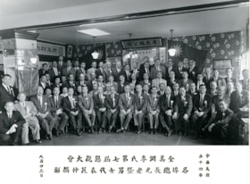
Lee's Benevolent Association of Canada
https://search.heritageburnaby.ca/link/museumdescription16724
- Repository
- Burnaby Village Museum
- Date
- 22 Aug. 1965, copied 2021
- Collection/Fonds
- Quon Lip Lee fonds
- Description Level
- Item
- Physical Description
- 1 photograph (tiff)
- Scope and Content
- Photograph of members of the Lee's Benevolent Association of Canada during the 7th Lee's Association North American Conference on August 22, 1965. Members identified include; Quon Lip Lee (second row from the back, sixth from the right) and Ron Bick Lee (front row, seventh from the left).
- Repository
- Burnaby Village Museum
- Collection/Fonds
- Quon Lip Lee fonds
- Description Level
- Item
- Physical Description
- 1 photograph (tiff)
- Scope and Content
- Photograph of members of the Lee's Benevolent Association of Canada during the 7th Lee's Association North American Conference on August 22, 1965. Members identified include; Quon Lip Lee (second row from the back, sixth from the right) and Ron Bick Lee (front row, seventh from the left).
- Geographic Access
- Vancouver
- Accession Code
- BV021.18.8
- Access Restriction
- No restrictions
- Reproduction Restriction
- May be restricted by third party rights
- Date
- 22 Aug. 1965, copied 2021
- Media Type
- Photograph
- Scan Resolution
- 600
- Scan Date
- April 8, 2021
- Scale
- 100
- Notes
- Title based on contents of photograph
- Chinese characters appear on the recto below the photograph
Images


Subdivision plans in New Westminster District Group 1 – Burnaby, Vancouver and map - Canada Department of Mines
https://search.heritageburnaby.ca/link/museumdescription6994
- Repository
- Burnaby Village Museum
- Date
- 1890-1909
- Collection/Fonds
- Burnaby Village Museum Map collection
- Description Level
- File
- Physical Description
- 1 plan : graphite on paper + 2 plans : black ink on paper + 1 map : col. on paper mounted on 2 sides of cardboard 76 x 102 cm
- Scope and Content
- Item consists of a large board with one New Westminster District subdivision plan mounted on one side and two New Westminster District subdivision plans and one colour map mounted on the other side. Side A: 1. "Plan / of Subdivision of / Blocks 2, 3, 4, 5, 6 / Lot 77 / Group 1 / New Westminster D…
- Repository
- Burnaby Village Museum
- Collection/Fonds
- Burnaby Village Museum Map collection
- Description Level
- File
- Physical Description
- 1 plan : graphite on paper + 2 plans : black ink on paper + 1 map : col. on paper mounted on 2 sides of cardboard 76 x 102 cm
- Material Details
- Scales 1:720 and 1:1200 and 1:.00001578
- Scope and Content
- Item consists of a large board with one New Westminster District subdivision plan mounted on one side and two New Westminster District subdivision plans and one colour map mounted on the other side. Side A: 1. "Plan / of Subdivision of / Blocks 2, 3, 4, 5, 6 / Lot 77 / Group 1 / New Westminster District / BC. / Scale 100 feet = 1 inch", "Deposited 8th day / of April 1890 / Mowileg [sic] / Dist. Regt". Plan is drawn in graphite with annotations: "AB_Parts_lettered_are_lots_in / the_different_subdivisions" / "Owners: / James E. Hall / P.S.Cabilan [sic] by his attorney Joseph Hall / Joseph Hall / Eliza J. Shannon / John Harrison"; "This plan is correct and is prepared under the / provisions of the Land Registry Act" ; signed by: "Gordon Herman & Burwell / Dominion & Provincial Land Surveryors / Vancouver March 19th/90" . Plan is initialed by: "RB" [sic] (in blue pencil crayon) and measures: 99.5 x 65 cm (Geographic location: Burnaby) Side B: 1. Map titled "Canada / Department of Mines / Geological Survey Branch" / "Hon.W Templeton, Minister / A.P. Low, Deputy Minister / R.W. Brock, Acting Director", Vol. XXXI, Plate I / Compiled under the direction of / James White, F.R.G.S. Geographer /Dep. of Interior". Note above map reads: "To illustrate Mr. James Barrowman's report as Delegate at the Excursion - meeting of the Canadian Mining Institute", "The instiitution of Mining Engineers / Transactions 1908 - 1909", "The Mining Institute of Scotland / Transactions 1908-1909". Map identifies minerals and includes a Legend and Scale: 100 miles = 1 inch 2. "Plan / of Subdivision of / Lot 4 / of Subdivision of / Lot 87. Gr. 1 / New Westminster District / Scale 60' = 1in." Plan is initialed by: "RB" [sic] along with a note "also Board / 48" (in blue pencil crayon) (Geographic location: Burnaby) 3. Plan of "Lot 335 / G. 1" west of Boundary Road and north of River Road - Vancouver. (Geographic location: Vancouver)
- Publisher
- The Mining Institute of Scotland
- Geographic Access
- Vancouver
- Accession Code
- HV977.93.25
- Access Restriction
- No restrictions
- Reproduction Restriction
- No known restrictions
- Date
- 1890-1909
- Media Type
- Cartographic Material
- Scan Resolution
- 300
- Scale
- 72
- Notes
- Title based on contents of file
- Scale is measured in feet and miles.
- The term "Lot" often refers to "District Lot"
Images


![Burnaby Rangers, [between 1960 and 1968] thumbnail](/media/hpo/_Data/_BVM_Images/2016/2016_0049_0113_001.jpg?width=280)
Burnaby Rangers
https://search.heritageburnaby.ca/link/museumdescription5220
- Repository
- Burnaby Village Museum
- Date
- [between 1960 and 1968]
- Collection/Fonds
- Burnaby Girl Guides fonds
- Description Level
- Item
- Physical Description
- 1 photograph : col. ; 9 x 12.5 cm
- Scope and Content
- Photograph of an unidentified group of Burnaby Rangers dressed in uniforms on a beach in Vancouver (could be Vanier Park) looking across to the Vancouver city skyline. Mrs. Isabelle Roper, Burnaby Area Commissioner is dressed in uniform and standing on the far left.
- Repository
- Burnaby Village Museum
- Collection/Fonds
- Burnaby Girl Guides fonds
- Description Level
- Item
- Physical Description
- 1 photograph : col. ; 9 x 12.5 cm
- Scope and Content
- Photograph of an unidentified group of Burnaby Rangers dressed in uniforms on a beach in Vancouver (could be Vanier Park) looking across to the Vancouver city skyline. Mrs. Isabelle Roper, Burnaby Area Commissioner is dressed in uniform and standing on the far left.
- Geographic Access
- Vancouver
- Accession Code
- BV016.49.113
- Access Restriction
- No restrictions
- Date
- [between 1960 and 1968]
- Media Type
- Photograph
- Notes
- Title based on content of photograph
Images
![Burnaby Rangers, [between 1960 and 1968] thumbnail](/media/hpo/_Data/_BVM_Images/2016/2016_0049_0113_001.jpg)
![Mary Davis and her mother Edith Finney, [between 1950 and 1960] thumbnail](/media/hpo//_Data/_BVM_Images/2017/2017_0050_0004_001.jpg?width=280)
Mary Davis and her mother Edith Finney
https://search.heritageburnaby.ca/link/museumdescription4938
- Repository
- Burnaby Village Museum
- Date
- [between 1950 and 1960]
- Collection/Fonds
- Burnaby Village Museum Photograph collection
- Description Level
- Item
- Physical Description
- 1 photograph : sepia ; 11.5 x 8 cm
- Scope and Content
- Mary Davis and her mother Edith Finney walking hand and hand down a busy commercial street.
- Repository
- Burnaby Village Museum
- Collection/Fonds
- Burnaby Village Museum Photograph collection
- Description Level
- Item
- Physical Description
- 1 photograph : sepia ; 11.5 x 8 cm
- Scope and Content
- Mary Davis and her mother Edith Finney walking hand and hand down a busy commercial street.
- History
- Mary Davis was born February 3, 1910 in Stafford, England to Sam and Edith Finney and came to Canada as a child. Her family settled in Saskatchewan. She married her first husband, Clifford Reynolds Hamilton in 1940 in Rossland BC and was subsequently divorced in 1949 in Vancouver BC. She moved to Burnaby somtime between 1940 and the mid-1950's. Mary owned Davis Confectionary with her second husband (presumably named Davis) at the corner of Beresford and MacPherson. The store acted as a grocery store and also a drug store. Mary and her husband owned the store in the 1950's /1960's. Mary passed away in 2001, and had no children. Photograph was taken by famous Vancouver street photographer Foncie Pulice. Foncie began working as a street photographer in 1934 and retired in 1979. Foncie died in 2003.
- Names
- Finney, Edith
- Davis, Mary
- Geographic Access
- Vancouver
- Accession Code
- BV017.50.4
- Access Restriction
- No restrictions
- Reproduction Restriction
- May be restricted by third party rights
- Date
- [between 1950 and 1960]
- Media Type
- Photograph
- Scan Resolution
- 600
- Scan Date
- 12-Jun-2018
- Photographer
- Pulice, Foncie
- Notes
- Title base on contents of photograph
- Stamped on verso: "FONCIE'S FOTOS/ 505 GRANVILLE ST./ VANCOUVER, B.C."
Images
![Mary Davis and her mother Edith Finney, [between 1950 and 1960] thumbnail](/media/hpo//_Data/_BVM_Images/2017/2017_0050_0004_001.jpg)