Narrow Results By
Subject
- Advertising Medium - Signs and Signboards 4
- Aerial Photographs 11
- Agricultural Tools and Equipment 2
- Agriculture - Farms 6
- Animals - Dogs 1
- Arts 2
- Buildings - Commercial - Grocery Stores 1
- Buildings - Commercial - Malls 9
- Buildings - Commercial - Restaurants 1
- Buildings - Commercial - Stores 2
- Buildings - Commercial - Train Stations 1
- Buildings - Recreational - Gymnasiums 1

Lougheed Highway
https://search.heritageburnaby.ca/link/archivedescription79940
- Repository
- City of Burnaby Archives
- Date
- July, 1976
- Collection/Fonds
- Burnaby Public Library Contemporary Visual Archive Project
- Description Level
- Item
- Physical Description
- 1 photograph : b&w ; 11 x 16 cm mounted on cardboard
- Scope and Content
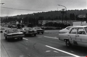
- Photograph shows an aerial view looking east along Lougheed Highway at Salish Court Towers with the Cariboo Shopping Centre in the background.
- Repository
- City of Burnaby Archives
- Date
- July, 1976
- Collection/Fonds
- Burnaby Public Library Contemporary Visual Archive Project
- Physical Description
- 1 photograph : b&w ; 11 x 16 cm mounted on cardboard
- Description Level
- Item
- Record No.
- 556-511
- Access Restriction
- No restrictions
- Reproduction Restriction
- Reproduce for fair dealing purposes only
- Accession Number
- 2013-13
- Scope and Content
- Photograph shows an aerial view looking east along Lougheed Highway at Salish Court Towers with the Cariboo Shopping Centre in the background.
- Media Type
- Photograph
- Photographer
- Gardiner, Robert
- Notes
- Scope note taken directly from BPL photograph description.
- 1 b&w copy negative : 10 x 12.5 cm accompanying
- Geographic Access
- Lougheed Highway
- Historic Neighbourhood
- Burquitlam (Historic Neighbourhood)
- Planning Study Area
- Cameron Area
Images

North Road
https://search.heritageburnaby.ca/link/archivedescription79983
- Repository
- City of Burnaby Archives
- Date
- September 22, 1976
- Collection/Fonds
- Burnaby Public Library Contemporary Visual Archive Project
- Description Level
- Item
- Physical Description
- 1 photograph : b&w ; 11 x 16 cm mounted on cardboard
- Scope and Content
- Photograph shows a view of North Road looking southwest toward Burnaby from Austin Road.
- Repository
- City of Burnaby Archives
- Date
- September 22, 1976
- Collection/Fonds
- Burnaby Public Library Contemporary Visual Archive Project
- Physical Description
- 1 photograph : b&w ; 11 x 16 cm mounted on cardboard
- Description Level
- Item
- Record No.
- 556-539
- Access Restriction
- No restrictions
- Reproduction Restriction
- Reproduce for fair dealing purposes only
- Accession Number
- 2013-13
- Scope and Content
- Photograph shows a view of North Road looking southwest toward Burnaby from Austin Road.
- Media Type
- Photograph
- Photographer
- Campbell, Peg
- Notes
- Scope note taken directly from BPL photograph description.
- 1 b&w copy negative : 10 x 12.5 cm accompanying
- Geographic Access
- North Road
- Historic Neighbourhood
- Burquitlam (Historic Neighbourhood)
- Planning Study Area
- Cameron Area
Images

Construction of MacInnis Place
https://search.heritageburnaby.ca/link/archivedescription45401
- Repository
- City of Burnaby Archives
- Date
- 1975
- Collection/Fonds
- Columbian Newspaper collection
- Description Level
- Item
- Physical Description
- 1 photograph : b&w ; 21 x 14.5 cm
- Scope and Content
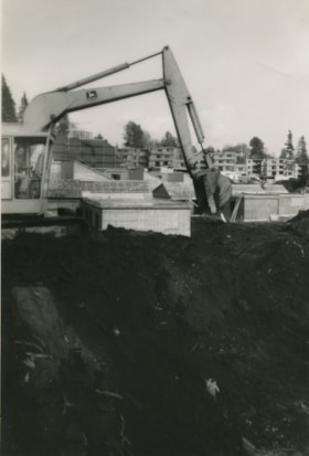
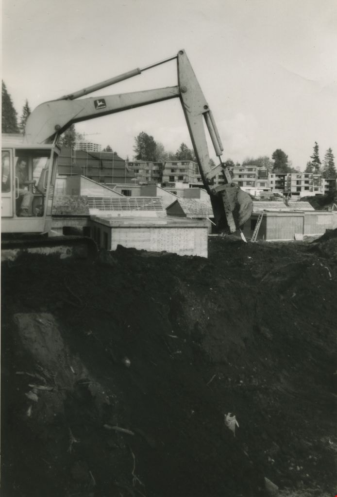
- Photograph of caterpiliar operator Casey Logan moving a large pile of earth to build a sound barrier for the British Columbia government housing project at MacInnis Place.
- Repository
- City of Burnaby Archives
- Date
- 1975
- Collection/Fonds
- Columbian Newspaper collection
- Physical Description
- 1 photograph : b&w ; 21 x 14.5 cm
- Description Level
- Item
- Record No.
- 480-296
- Access Restriction
- No restrictions
- Reproduction Restriction
- Reproduce for fair dealing purposes only
- Accession Number
- 2003-02
- Scope and Content
- Photograph of caterpiliar operator Casey Logan moving a large pile of earth to build a sound barrier for the British Columbia government housing project at MacInnis Place.
- Names
- MacInnis Place
- Media Type
- Photograph
- Notes
- Title based on contents of photograph
- Newspaper clipping attached to verso of photograph reads: "BIG BARRIER Mountain of earth is moved by 'cat' operator Casey Logan to build a sound barrier for the new B.C. government housing project at MacInnis Place in Burnaby."
- Geographic Access
- Keswick Avenue
- Historic Neighbourhood
- Burquitlam (Historic Neighbourhood)
- Planning Study Area
- Cameron Area
Images
Grace MacInnis
https://search.heritageburnaby.ca/link/archivedescription45402
- Repository
- City of Burnaby Archives
- Date
- May 1975
- Collection/Fonds
- Columbian Newspaper collection
- Description Level
- Item
- Physical Description
- 1 photograph : b&w ;19.5 x 14 cm
- Scope and Content
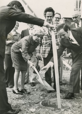
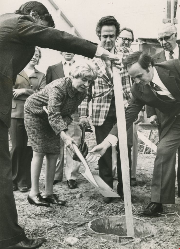
- Photograph of former Member of Parliament Grace MacInnis burying the time capsule at the official sod turning Friday for the government -owned MacInnis housing complex. Housing Minister Lorne Nicolson and Member of the Legislative Assembly Gordon Dowding were also in attendance.
- Repository
- City of Burnaby Archives
- Date
- May 1975
- Collection/Fonds
- Columbian Newspaper collection
- Physical Description
- 1 photograph : b&w ;19.5 x 14 cm
- Description Level
- Item
- Record No.
- 480-297
- Access Restriction
- No restrictions
- Reproduction Restriction
- No restrictions
- Accession Number
- 2003-02
- Scope and Content
- Photograph of former Member of Parliament Grace MacInnis burying the time capsule at the official sod turning Friday for the government -owned MacInnis housing complex. Housing Minister Lorne Nicolson and Member of the Legislative Assembly Gordon Dowding were also in attendance.
- Subjects
- Officials - Elected Officials
- Media Type
- Photograph
- Photographer
- King, Basil
- Notes
- Title based on contents of photograph
- Newspaper clipping attached to verso of photograph reads: "Former MP Grace MacInnis buries the time capsule at the official sod turning Friday for the government -owned MacInnis housing complex on Government Road [sic] in Burnaby. Keeping a close eye on the ceremony are Housing Minister Lorne Nicolson and MLA Gordon Dowding, speaker of the House. The complex is to be called MacInnes Place and is a B.C. government comprehensive housing project."
- Geographic Access
- Keswick Avenue
- Historic Neighbourhood
- Burquitlam (Historic Neighbourhood)
- Planning Study Area
- Cameron Area
Images
Lougheed Village high-rises
https://search.heritageburnaby.ca/link/archivedescription56669
- Repository
- City of Burnaby Archives
- Date
- April 1975
- Collection/Fonds
- Columbian Newspaper collection
- Description Level
- Item
- Physical Description
- 1 photograph : b&w ; 13.5 x 19 cm
- Scope and Content
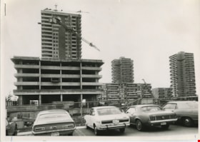
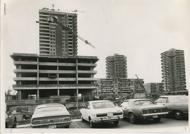
- Photograph of the construction of two high-rise towers in Lougheed Village.
- Repository
- City of Burnaby Archives
- Date
- April 1975
- Collection/Fonds
- Columbian Newspaper collection
- Physical Description
- 1 photograph : b&w ; 13.5 x 19 cm
- Description Level
- Item
- Record No.
- 480-1252
- Access Restriction
- No restrictions
- Reproduction Restriction
- Reproduce for fair dealing purposes only
- Accession Number
- 2003-02
- Scope and Content
- Photograph of the construction of two high-rise towers in Lougheed Village.
- Subjects
- Buildings - Residential - Apartments
- Names
- Lougheed Village
- Media Type
- Photograph
- Notes
- Title based on contents of photograph
- Newspaper clipping attached to verso of photograph reads: "GOING UP AND UP - Hive of concrete construction activity is at the Lougheed Village where construction of two more high-rise towers is well underway in the already built-up high-density area around Lougheed Mall. Tower nearer completion is 24 storeys high."
- Historic Neighbourhood
- Burquitlam (Historic Neighbourhood)
- Planning Study Area
- Cameron Area
Images
Proposed Condominium Apartments - Erickson/Bartlett/Cameron Area (Rezoning Reference # 28/74) Community Plan Area "G"
https://search.heritageburnaby.ca/link/councilreport26603
- Repository
- City of Burnaby Archives
- Report ID
- 19801
- Meeting Date
- 8-Jul-1974
- Format
- Council - Manager's Report
- Manager's Report No.
- 49
- Item No.
- 13
- Collection/Fonds
- City Council and Office of the City Clerk fonds
- Repository
- City of Burnaby Archives
- Report ID
- 19801
- Meeting Date
- 8-Jul-1974
- Format
- Council - Manager's Report
- Manager's Report No.
- 49
- Item No.
- 13
- Collection/Fonds
- City Council and Office of the City Clerk fonds
Documents

Cystic Fibrosis fundraiser
https://search.heritageburnaby.ca/link/archivedescription45447
- Repository
- City of Burnaby Archives
- Date
- September 1973
- Collection/Fonds
- Columbian Newspaper collection
- Description Level
- Item
- Physical Description
- 1 photograph : b&w ; 16.5 x 19.5 cm
- Scope and Content
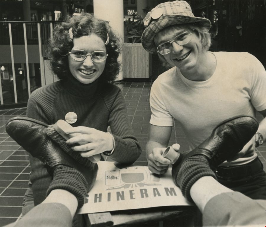
- Photograph of Columbian photographer Basil King getting his shoes shined by British Columbia Institute of Technology students Kathy McLeod and Russ Carmichael at Lougheed mall (now Lougheed Town Centre). This was part of the Cystic Fibrosis fundraiser known as Shinerama.
- Repository
- City of Burnaby Archives
- Date
- September 1973
- Collection/Fonds
- Columbian Newspaper collection
- Physical Description
- 1 photograph : b&w ; 16.5 x 19.5 cm
- Description Level
- Item
- Record No.
- 480-342
- Access Restriction
- No restrictions
- Reproduction Restriction
- No restrictions
- Accession Number
- 2003-02
- Scope and Content
- Photograph of Columbian photographer Basil King getting his shoes shined by British Columbia Institute of Technology students Kathy McLeod and Russ Carmichael at Lougheed mall (now Lougheed Town Centre). This was part of the Cystic Fibrosis fundraiser known as Shinerama.
- Names
- British Columbia Institute of Technology
- Lougheed Town Centre
- King, Basil
- McLeod, Kathy
- Carmichael, Russ
- Media Type
- Photograph
- Photographer
- King, Basil
- Notes
- Title based on contents of photograph
- Newspaper clipping attached to verso of photograph reads: "The shoes in need of a shine are Columbian photographer Basil King's. The cheerful shiners at Lougheed mall today are Kathy McLeod and Russ Carmichael. The occasion: Shinerama '73. Hundreds of B.C. Institute of Technology students are on the job at Lower Mainland shopping centres, raising funds for cystic fibrosis research."
- Geographic Access
- North Road
- Austin Road
- Historic Neighbourhood
- Burquitlam (Historic Neighbourhood)
- Planning Study Area
- Cameron Area
Images
Bylaw Number: 5713 - Expropriation Abandonment Bylaw No 1, 1970
https://search.heritageburnaby.ca/link/bylaw18657
- Repository
- Legislative Services
- Bylaw Number
- 5713
- Final Adoption
- 1970 May 25
- Format
- Bylaws - Adopted
- Collection/Fonds
- City Council and Office of the City Clerk fonds
- Repository
- Legislative Services
- Bylaw Number
- 5713
- Final Adoption
- 1970 May 25
- Format
- Bylaws - Adopted
- Collection/Fonds
- City Council and Office of the City Clerk fonds
Documents

Burquitlam Neighbourhood
https://search.heritageburnaby.ca/link/landmark734
- Repository
- Burnaby Heritage Planning
- Repository
- Burnaby Heritage Planning
- Heritage Value
- Burnaby's first non-Native settler, William Holmes, selected land near the Brunette River on which to build his home in 1860. From this beginning, the neighbourhood of Burquitlam developed, fostered by its proximity to the North Road trail which linked it to New Westminster. In 1906, the Burquitlam Post Office opened and in 1910 the Hamilton Road school opened to serve the growing population of children in the area.
- Historic Neighbourhood
- Burquitlam (Historic Neighbourhood)
- Planning Study Area
- Cameron Area
- Lyndhurst Area
Images

Burquitlam Neighbourhood
https://search.heritageburnaby.ca/link/landmark757
- Repository
- Burnaby Heritage Planning
- Associated Dates
- 1905-1924
- Heritage Value
- In 1921, the pamphlet "Beautiful Burnaby" was produced and it described the Burquitlam neighbourhood as such: "No part of Burnaby has more consistently laboured to advance its prosperity than Burquitlam. Enterprise and intelligence has hewn homes from the forest and developed land into highly productive gardens and poultry ranches. Burquitlam is the growing suburb to the north of the City of New Westminster. It is reached by the Sapperton carline direct from Edmonds being only a few minutes ride from New Westminster market. It is also served by the B.C.E.R. Burnaby Lake line and adjoins on the best golf links in Greater Vancouver."
- Historic Neighbourhood
- Burquitlam (Historic Neighbourhood)
- Planning Study Area
- Cameron Area
- Lyndhurst Area
Images

Cameron Neighbourhood
https://search.heritageburnaby.ca/link/landmark824
- Repository
- Burnaby Heritage Planning
- Associated Dates
- 1955-2008
- Heritage Value
- The Cameron Neighbourhood falls within the Lougheed Town Centre area - one of four Town Centres in Burnaby. The Cameron Neighbourhood - while containing significant high-density residential components - is also home to the Town Centre's office and commercial core. The Lougheed Mall is situated in this neighbourhood, which is served by the Millennium Line SkyTrain.
- Historic Neighbourhood
- Burquitlam (Historic Neighbourhood)
- Planning Study Area
- Cameron Area
Images


Opening of Lougheed Mall
https://search.heritageburnaby.ca/link/archivedescription37401
- Repository
- City of Burnaby Archives
- Date
- September 1969
- Collection/Fonds
- Burnaby Historical Society fonds
- Description Level
- Item
- Physical Description
- 1 photograph : b&w ; 17.9 x 23 cm
- Scope and Content
- Photograph of Burnaby Mayor Robert Prittie, with Miss PNE, Patsy McPhee, cutting the ribbon at the opening of Lougheed Mall (now Lougheed Town Centre).
- Repository
- City of Burnaby Archives
- Date
- September 1969
- Collection/Fonds
- Burnaby Historical Society fonds
- Subseries
- Robert Prittie subseries
- Physical Description
- 1 photograph : b&w ; 17.9 x 23 cm
- Description Level
- Item
- Record No.
- 368-002
- Access Restriction
- No restrictions
- Reproduction Restriction
- Reproduce for fair dealing purposes only
- Accession Number
- BHS1999-01
- Scope and Content
- Photograph of Burnaby Mayor Robert Prittie, with Miss PNE, Patsy McPhee, cutting the ribbon at the opening of Lougheed Mall (now Lougheed Town Centre).
- Media Type
- Photograph
- Photographer
- LeBlanc, Don
- Notes
- Title based on contents of photograph
- Geographic Access
- Austin Road
- Street Address
- 9855 Austin Avenue
- Historic Neighbourhood
- Burquitlam (Historic Neighbourhood)
- Planning Study Area
- Cameron Area
Images

Bylaw Number: 5406 - Expropriation Bylaw No 7, 1968
https://search.heritageburnaby.ca/link/bylaw18963
- Repository
- Legislative Services
- Bylaw Number
- 5406
- Final Adoption
- 1968 Sep 23
- Format
- Bylaws - Adopted
- Collection/Fonds
- City Council and Office of the City Clerk fonds
- Repository
- Legislative Services
- Bylaw Number
- 5406
- Final Adoption
- 1968 Sep 23
- Format
- Bylaws - Adopted
- Collection/Fonds
- City Council and Office of the City Clerk fonds
Documents

Cameron Elementary School
https://search.heritageburnaby.ca/link/landmark833
- Repository
- Burnaby Heritage Planning
- Geographic Access
- Erickson Drive
- Associated Dates
- 1965
- Heritage Value
- The increasing density of housing around the Lougheed Shopping Centre area resulted in a spike in enrolment at Lyndhurst Elementary School. As a result, in 1965, Cameron Road Elementary was built to alleviate overcrowding issues. The school opened with 151 pupils. The school was expanded in 1969 when three classrooms were added and again in 1971 when eights more rooms and a library were built.
- Historic Neighbourhood
- Burquitlam (Historic Neighbourhood)
- Planning Study Area
- Cameron Area
- Street Address
- 9540 Erickson Drive
- Street View URL
- Google Maps Street View
Images

Aerial photograph of Burnaby and Coquitlam
https://search.heritageburnaby.ca/link/archivedescription84912
- Repository
- City of Burnaby Archives
- Date
- 1963
- Collection/Fonds
- Allan Amundsen collection
- Description Level
- Item
- Physical Description
- 1 photograph : b&w ; 22.5 x 22.5 cm
- Scope and Content
- Aerial photograph of Burnaby and Coquitlam with North Road running through the centre.
- Repository
- City of Burnaby Archives
- Date
- 1963
- Collection/Fonds
- Allan Amundsen collection
- Physical Description
- 1 photograph : b&w ; 22.5 x 22.5 cm
- Description Level
- Item
- Record No.
- 561-030
- Access Restriction
- In Archives only
- Reproduction Restriction
- No reproduction permitted
- Accession Number
- 2014-08
- Scope and Content
- Aerial photograph of Burnaby and Coquitlam with North Road running through the centre.
- Subjects
- Aerial Photographs
- Media Type
- Photograph
- Photographer
- Province of British Columbia
- Notes
- Title based on contents of photograph
- This photo is indentified as BC5062:21 and connects with B.C. air photograph BC5062:22 to the west and BC5062:70 to the east
- Historic Neighbourhood
- Burquitlam (Historic Neighbourhood)
- Planning Study Area
- Cameron Area
- Lyndhurst Area
- Cariboo-Armstrong Area
Aerial photograph of Burnaby
https://search.heritageburnaby.ca/link/archivedescription84913
- Repository
- City of Burnaby Archives
- Date
- 1963
- Collection/Fonds
- Allan Amundsen collection
- Description Level
- Item
- Physical Description
- 1 photograph : b&w ; 22.5 x 22.5 cm
- Scope and Content
- Aerial photograph of East Burnaby up to North Road and south of the Trans Canada Highway.
- Repository
- City of Burnaby Archives
- Date
- 1963
- Collection/Fonds
- Allan Amundsen collection
- Physical Description
- 1 photograph : b&w ; 22.5 x 22.5 cm
- Description Level
- Item
- Record No.
- 561-031
- Access Restriction
- In Archives only
- Reproduction Restriction
- No reproduction permitted
- Accession Number
- 2014-08
- Scope and Content
- Aerial photograph of East Burnaby up to North Road and south of the Trans Canada Highway.
- Subjects
- Aerial Photographs
- Media Type
- Photograph
- Photographer
- Province of British Columbia
- Notes
- Title based on contents of photograph
- This photo is indentified as BC5062:70 and connects with B.C. air photograph BC5062:21 to the west and BC5062:71 to the east
- Historic Neighbourhood
- East Burnaby (Historic Neighbourhood)
- Planning Study Area
- Cameron Area
- Cariboo-Armstrong Area
Aerial photograph of Burnaby and Coquitlam
https://search.heritageburnaby.ca/link/archivedescription84914
- Repository
- City of Burnaby Archives
- Date
- 1963
- Collection/Fonds
- Allan Amundsen collection
- Description Level
- Item
- Physical Description
- 1 photograph : b&w ; 22.5 x 22.5 cm
- Scope and Content
- Aerial photograph of East Burnaby and Coquitlam with North Road running through the centre.
- Repository
- City of Burnaby Archives
- Date
- 1963
- Collection/Fonds
- Allan Amundsen collection
- Physical Description
- 1 photograph : b&w ; 22.5 x 22.5 cm
- Description Level
- Item
- Record No.
- 561-032
- Access Restriction
- In Archives only
- Reproduction Restriction
- No reproduction permitted
- Accession Number
- 2014-08
- Scope and Content
- Aerial photograph of East Burnaby and Coquitlam with North Road running through the centre.
- Subjects
- Aerial Photographs
- Media Type
- Photograph
- Photographer
- Province of British Columbia
- Notes
- Title based on contents of photograph
- This photo is indentified as BC5062:71 and connects with B.C. air photograph BC5062:70 to the west
- Historic Neighbourhood
- East Burnaby (Historic Neighbourhood)
- Planning Study Area
- Cameron Area
- Cariboo-Armstrong Area
![Stiglish family dog, [196-] (date of original), digitally copied 2013 thumbnail](/media/hpo/_Data/_Archives_Images/_Unrestricted/550/552-001.jpg?width=280)
Stiglish family dog
https://search.heritageburnaby.ca/link/archivedescription77187
- Repository
- City of Burnaby Archives
- Date
- [196-] (date of original), digitally copied 2013
- Collection/Fonds
- Stiglish family fonds
- Description Level
- Item
- Physical Description
- 1 photograph : b&w copy-print ; 9 x 9 cm
- Scope and Content
- Photograph of Dinah, the Stiglish family's Rough Collie on the family property (this property included the F.J. Stiglish mushroom farm). Mushroom houses are visible in the background.
- Repository
- City of Burnaby Archives
- Date
- [196-] (date of original), digitally copied 2013
- Collection/Fonds
- Stiglish family fonds
- Physical Description
- 1 photograph : b&w copy-print ; 9 x 9 cm
- Description Level
- Item
- Record No.
- 552-001
- Access Restriction
- No restrictions
- Reproduction Restriction
- Reproduce for fair dealing purposes only
- Accession Number
- 2013-07
- Scope and Content
- Photograph of Dinah, the Stiglish family's Rough Collie on the family property (this property included the F.J. Stiglish mushroom farm). Mushroom houses are visible in the background.
- Subjects
- Agriculture - Farms
- Animals - Dogs
- Names
- Stiglish, F.J. "Jack"
- Media Type
- Photograph
- Notes
- Title based on contents of photograph
- Note in blue ink on verso of photograph reads: "F.J. Stiglish mushroom farm / 3782 Keswick Ave / Burnaby 3 / before changed address 1050 Keswick Ave / probably 1960s / mushroom houses in background garage with a suite above it, used for parties."
- Original spelling of surname was "Stiglich"
- Geographic Access
- Keswick Avenue
- Street Address
- 3782 Keswick Avenue
- Historic Neighbourhood
- Burquitlam (Historic Neighbourhood)
- Planning Study Area
- Cameron Area
Images
![Stiglish family dog, [196-] (date of original), digitally copied 2013 thumbnail](/media/hpo/_Data/_Archives_Images/_Unrestricted/550/552-001.jpg)
![Mushroom farm houses, [196-] (date of original), digitally copied 2013 thumbnail](/media/hpo/_Data/_Archives_Images/_Unrestricted/550/552-002.jpg?width=280)
Mushroom farm houses
https://search.heritageburnaby.ca/link/archivedescription77188
- Repository
- City of Burnaby Archives
- Date
- [196-] (date of original), digitally copied 2013
- Collection/Fonds
- Stiglish family fonds
- Description Level
- Item
- Physical Description
- 1 photograph : b&w copy-print ; 9 x 9 cm
- Scope and Content
- Photograph of the mushroom farm houses on the Stiglish family property (this property included the F.J. Stiglish mushroom farm).
- Repository
- City of Burnaby Archives
- Date
- [196-] (date of original), digitally copied 2013
- Collection/Fonds
- Stiglish family fonds
- Physical Description
- 1 photograph : b&w copy-print ; 9 x 9 cm
- Description Level
- Item
- Record No.
- 552-002
- Access Restriction
- No restrictions
- Reproduction Restriction
- Reproduce for fair dealing purposes only
- Accession Number
- 2013-07
- Scope and Content
- Photograph of the mushroom farm houses on the Stiglish family property (this property included the F.J. Stiglish mushroom farm).
- Subjects
- Agriculture - Farms
- Names
- Stiglish, F.J. "Jack"
- Media Type
- Photograph
- Notes
- Title based on contents of photograph
- Note in blue ink on verso of photograph reads: "mushroom farm houses / F.J. Stiglish mushroom farm / 3782 Keswick Ave / Burnaby 3 / previous 1050 Keswick Ave /1960s"
- Original spelling of surname was "Stiglich"
- Geographic Access
- Keswick Avenue
- Street Address
- 3782 Keswick Avenue
- Historic Neighbourhood
- Burquitlam (Historic Neighbourhood)
- Planning Study Area
- Cameron Area
Images
![Mushroom farm houses, [196-] (date of original), digitally copied 2013 thumbnail](/media/hpo/_Data/_Archives_Images/_Unrestricted/550/552-002.jpg)
![Trailers on the Stiglish property, [196-] (date of original), digitally copied 2013 thumbnail](/media/hpo/_Data/_Archives_Images/_Unrestricted/550/552-007.jpg?width=280)
Trailers on the Stiglish property
https://search.heritageburnaby.ca/link/archivedescription77193
- Repository
- City of Burnaby Archives
- Date
- [196-] (date of original), digitally copied 2013
- Collection/Fonds
- Stiglish family fonds
- Description Level
- Item
- Physical Description
- 1 photograph : b&w copy-print ; 9 x 9 cm
- Scope and Content
- Photograph of the overflow of Jehovah Witness convention goers staying on the Stiglish property because the four acre trailer park, in Coquitlam, British Columbia that Jack Stiglish owned, was full.
- Repository
- City of Burnaby Archives
- Date
- [196-] (date of original), digitally copied 2013
- Collection/Fonds
- Stiglish family fonds
- Physical Description
- 1 photograph : b&w copy-print ; 9 x 9 cm
- Description Level
- Item
- Record No.
- 552-007
- Access Restriction
- No restrictions
- Reproduction Restriction
- Reproduce for fair dealing purposes only
- Accession Number
- 2013-07
- Scope and Content
- Photograph of the overflow of Jehovah Witness convention goers staying on the Stiglish property because the four acre trailer park, in Coquitlam, British Columbia that Jack Stiglish owned, was full.
- Names
- Stiglish, F.J. "Jack"
- Media Type
- Photograph
- Notes
- Title based on contents of photograph
- Note in blue ink on verso of photograph reads: "father owned four acre Trailer Court in Coquitlam / Jehovah Witness convention overflow from trailer park"
- Original spelling of surname was "Stiglich"
- Geographic Access
- Keswick Avenue
- Street Address
- 3782 Keswick Avenue
- Historic Neighbourhood
- Burquitlam (Historic Neighbourhood)
- Planning Study Area
- Cameron Area
Images
![Trailers on the Stiglish property, [196-] (date of original), digitally copied 2013 thumbnail](/media/hpo/_Data/_Archives_Images/_Unrestricted/550/552-007.jpg)