Narrow Results By
Subject
- Agriculture - Farms 4
- Buildings - Residential - Houses 4
- Buildings - Schools 1
- Education 1
- First Nations reserves - British Columbia 1
- Geographic Features - Lakes and Ponds 3
- Geographic Features - Roads 1
- Indigenous peoples - Indian Territory 1
- Migration 1
- Persons - South Asian Canadians 1
- Sports 1
- Sports - Football 1
Person / Organization
- Burnaby Central Secondary School 1
- Ceperley, Grace 1
- Douglas Road School 2
- Dowad, Kathleen "Kay" 1
- Dowad, Martha Elias Shaheen 1
- Dowad, Naomi "Mamie" David 1
- Dowad, Norman W. "Norm" 1
- Dowad, Samuel Esper "Sam" 1
- Dowad, Wilfred "Wilf" 1
- Fraser Valley Nurseries 2
- Hill, Louis Claude "Claude" 1
- McMurray, Murdoch 1
![B.R. Hill house, [1910] thumbnail](/media/hpo/_Data/_BVM_Images/1976/1976_0051_0001_001.jpg?width=280)
B.R. Hill house
https://search.heritageburnaby.ca/link/museumdescription740
- Repository
- Burnaby Village Museum
- Date
- [1910]
- Collection/Fonds
- Burnaby Village Museum Photograph collection
- Description Level
- Item
- Physical Description
- 1 photograph : b&w photogravure ; 8.1 x 10.7 cm
- Scope and Content
- Photograph is photogravure printed on paper of a house on the side of a path. The area appears wooded. The inscription and the accession register identify the house as the residence of Mr. and Mrs. B.R. Hill on Douglas Road, built about 1892, with an addition to the house built about 1905.
- Repository
- Burnaby Village Museum
- Collection/Fonds
- Burnaby Village Museum Photograph collection
- Description Level
- Item
- Physical Description
- 1 photograph : b&w photogravure ; 8.1 x 10.7 cm
- Material Details
- An annotation in pencil is written on the back of the photograph
- Scope and Content
- Photograph is photogravure printed on paper of a house on the side of a path. The area appears wooded. The inscription and the accession register identify the house as the residence of Mr. and Mrs. B.R. Hill on Douglas Road, built about 1892, with an addition to the house built about 1905.
- Subjects
- Buildings - Residential - Houses
- Geographic Access
- Canada Way
- Douglas Road
- Street Address
- 4990 Canada Way
- Accession Code
- HV976.51.1
- Access Restriction
- No restrictions
- Reproduction Restriction
- May be restricted by third party rights
- Date
- [1910]
- Media Type
- Photograph
- Historic Neighbourhood
- Burnaby Lake (Historic Neighbourhood)
- Planning Study Area
- Douglas-Gilpin Area
- Scan Resolution
- 600
- Scan Date
- 2023-06-20
- Notes
- Title based on contents of photograph
Images
![B.R. Hill house, [1910] thumbnail](/media/hpo/_Data/_BVM_Images/1976/1976_0051_0001_001.jpg)
![Deer Lake, [1914] thumbnail](/media/hpo/_Data/_BVM_Images/1971/197200110006.jpg?width=280)
Deer Lake
https://search.heritageburnaby.ca/link/museumdescription3092
- Repository
- Burnaby Village Museum
- Date
- [1914]
- Collection/Fonds
- Burnaby Village Museum Photograph collection
- Description Level
- Item
- Physical Description
- 1 photograph : b&w glass negative ; 16.0 x 20.9 cm
- Scope and Content
- Photograph of the north shore of Deer Lake looking northwest. According to a 1988 catalogue record, visible is the T.O. Townley house, "Deerholme," and the Gardener's cottage (marred by a stain). Ceperley's "Fairacres" is also visible to the extreme right of the contact print, including a boathous…
- Repository
- Burnaby Village Museum
- Collection/Fonds
- Burnaby Village Museum Photograph collection
- Description Level
- Item
- Physical Description
- 1 photograph : b&w glass negative ; 16.0 x 20.9 cm
- Scope and Content
- Photograph of the north shore of Deer Lake looking northwest. According to a 1988 catalogue record, visible is the T.O. Townley house, "Deerholme," and the Gardener's cottage (marred by a stain). Ceperley's "Fairacres" is also visible to the extreme right of the contact print, including a boathouse on the shore which can be seen on the centre of the print.
- Geographic Access
- Price Street
- Deer Lake
- Street Address
- 6110 Price Street
- Accession Code
- HV972.11.6
- Access Restriction
- No restrictions
- Reproduction Restriction
- No known restrictions
- Date
- [1914]
- Media Type
- Photograph
- Historic Neighbourhood
- Burnaby Lake (Historic Neighbourhood)
- Planning Study Area
- Morley-Buckingham Area
- Related Material
- For other shots of the Deer Lake in the same accession, see HV972.11.16 and HV972.11.18
- Scan Resolution
- 300
- Scan Date
- 14/8/2006
- Scale
- 100
- Notes
- Title based on contents of photograph
- 1 b&w contact print accompanying negative
Images
![Deer Lake, [1914] thumbnail](/media/hpo/_Data/_BVM_Images/1971/197200110006.jpg)

Deer Lake
https://search.heritageburnaby.ca/link/museumdescription3102
- Repository
- Burnaby Village Museum
- Date
- 1914
- Collection/Fonds
- Burnaby Village Museum Photograph collection
- Description Level
- Item
- Physical Description
- 1 photograph : b&w glass negative ; 16.0 x 20.9 cm
- Scope and Content
- Photograph of Deer Lake. An earlier catalogue record from 1988 notes that the view is of the north shore of Deer Lake, looking northeast. Also noted is that the Hart's boathouse is in view at the mouth of Deer Lake Brook, and that the Anderson and Mathers houses on can be seen on Deer Lake Avenue
- Repository
- Burnaby Village Museum
- Collection/Fonds
- Burnaby Village Museum Photograph collection
- Description Level
- Item
- Physical Description
- 1 photograph : b&w glass negative ; 16.0 x 20.9 cm
- Scope and Content
- Photograph of Deer Lake. An earlier catalogue record from 1988 notes that the view is of the north shore of Deer Lake, looking northeast. Also noted is that the Hart's boathouse is in view at the mouth of Deer Lake Brook, and that the Anderson and Mathers houses on can be seen on Deer Lake Avenue
- Geographic Access
- Deer Lake Avenue
- Deer Lake Brook
- Street Address
- 6490 Deer Lake Avenue
- 6344 Deer Lake Avenue
- 6450 Deer Lake Avenue
- Accession Code
- HV972.11.16
- Access Restriction
- No restrictions
- Reproduction Restriction
- No known restrictions
- Date
- 1914
- Media Type
- Photograph
- Historic Neighbourhood
- Burnaby Lake (Historic Neighbourhood)
- Planning Study Area
- Douglas-Gilpin Area
- Related Material
- For other shots of the Deer Lake in the same accession, see HV972.11.6 and HV972.11.18
- Scan Resolution
- 300
- Scan Date
- 14/8/2006
- Scale
- 100
- Notes
- Title based on contents of photograph
- 1 b&w contact print accompanying negative
Images

![Deer Lake, [1914] thumbnail](/media/hpo/_Data/_BVM_Images/1971/197200110018.jpg?width=280)
Deer Lake
https://search.heritageburnaby.ca/link/museumdescription3104
- Repository
- Burnaby Village Museum
- Date
- [1914]
- Collection/Fonds
- Burnaby Village Museum Photograph collection
- Description Level
- Item
- Physical Description
- 1 photograph : b&w glass negative ; 16.4 x 21.2 cm
- Scope and Content
- Photograph of the north shore of Deer Lake as seen from the south shore. According to an earlier 1988 catalogue record, in view from left to right are: H.T. Ceperley's "Fairacres," The Mathers "Altnadene," and the Anderson house on the hill. On shoreline are the Hart's boathouse and beach cottage…
- Repository
- Burnaby Village Museum
- Collection/Fonds
- Burnaby Village Museum Photograph collection
- Description Level
- Item
- Physical Description
- 1 photograph : b&w glass negative ; 16.4 x 21.2 cm
- Scope and Content
- Photograph of the north shore of Deer Lake as seen from the south shore. According to an earlier 1988 catalogue record, in view from left to right are: H.T. Ceperley's "Fairacres," The Mathers "Altnadene," and the Anderson house on the hill. On shoreline are the Hart's boathouse and beach cottage and the Woodward's boathouse.
- Geographic Access
- Deer Lake Avenue
- Street Address
- 6490 Deer Lake Avenue
- 6344 Deer Lake Avenue
- Accession Code
- HV972.11.18
- Access Restriction
- No restrictions
- Reproduction Restriction
- No known restrictions
- Date
- [1914]
- Media Type
- Photograph
- Historic Neighbourhood
- Burnaby Lake (Historic Neighbourhood)
- Planning Study Area
- Lakeview-Mayfield Area
- Related Material
- For other shots of the Deer Lake in the same accession, see HV972.11.6 and HV972.11.16
- Scan Resolution
- 300
- Scan Date
- 14/8/2006
- Scale
- 100
- Notes
- Title based on contents of photograph
- 1 b&w contact print accompanying negative
Images
![Deer Lake, [1914] thumbnail](/media/hpo/_Data/_BVM_Images/1971/197200110018.jpg)
![Deer Lake Drive, [1918] thumbnail](/media/hpo/_Data/_BVM_Images/1972/1972_0051_0012_001.jpg?width=280)
Deer Lake Drive
https://search.heritageburnaby.ca/link/museumdescription1085
- Repository
- Burnaby Village Museum
- Date
- [1918]
- Collection/Fonds
- Burnaby Village Museum Photograph collection
- Description Level
- Item
- Physical Description
- 1 photograph : b&w ; 12.9 x 32.9 cm
- Scope and Content
- Photograph is a panorama of Deer Lake Drive, including the Ceperley mansion and the surrounding grounds of the home to the left of the picture. The photograph, taken from the water tower, with Burnaby Lake in the background. In the midground, following the horizon line, power poles can be seen. Far…
- Repository
- Burnaby Village Museum
- Collection/Fonds
- Burnaby Village Museum Photograph collection
- Description Level
- Item
- Physical Description
- 1 photograph : b&w ; 12.9 x 32.9 cm
- Scope and Content
- Photograph is a panorama of Deer Lake Drive, including the Ceperley mansion and the surrounding grounds of the home to the left of the picture. The photograph, taken from the water tower, with Burnaby Lake in the background. In the midground, following the horizon line, power poles can be seen. Farm lands are visible leading down to the homes of the Andersons. An annotation on the back of the photo in pencil reads, "Deer Lake Dr." and an annotation in blue pen reads, "1918."
- Geographic Access
- Deer Lake Drive
- Deer Lake Avenue
- Street Address
- 6344 Deer Lake Avenue
- Accession Code
- HV972.51.12
- Access Restriction
- No restrictions
- Reproduction Restriction
- No known restrictions
- Date
- [1918]
- Media Type
- Photograph
- Historic Neighbourhood
- Burnaby Lake (Historic Neighbourhood)
- Planning Study Area
- Douglas-Gilpin Area
- Scan Resolution
- 600
- Scan Date
- 2023-04-04
Images
![Deer Lake Drive, [1918] thumbnail](/media/hpo/_Data/_BVM_Images/1972/1972_0051_0012_001.jpg)

Douglas Road School site
https://search.heritageburnaby.ca/link/museumdescription11136
- Repository
- Burnaby Village Museum
- Date
- April 19, 1915
- Collection/Fonds
- Ronald G. Scobbie collection
- Description Level
- Item
- Physical Description
- 1 survey plan : blueprint on paper ; 56 x 54 cm
- Scope and Content
- Survey plan of "Douglas Road School Site / Burnaby Municipality" "Being Lot 21, of Blocks 1-5 inc. 11 & 12 of the subd. of north half of Lot 80, Group 1, New Westminster District".
- Repository
- Burnaby Village Museum
- Collection/Fonds
- Ronald G. Scobbie collection
- Description Level
- Item
- Physical Description
- 1 survey plan : blueprint on paper ; 56 x 54 cm
- Material Details
- Scale 40 feet = 1 inch
- Scope and Content
- Survey plan of "Douglas Road School Site / Burnaby Municipality" "Being Lot 21, of Blocks 1-5 inc. 11 & 12 of the subd. of north half of Lot 80, Group 1, New Westminster District".
- Creator
- McGugan, Donald Johnston
- Subjects
- Buildings - Schools
- Names
- Douglas Road School
- Responsibility
- Burnett & McGugan, Engineers and Surveyors
- Geographic Access
- Canada Way
- Street Address
- 4861 Canada Way
- Accession Code
- BV003.83.15
- Access Restriction
- No restrictions
- Reproduction Restriction
- No known restrictions
- Date
- April 19, 1915
- Media Type
- Cartographic Material
- Historic Neighbourhood
- Burnaby Lake (Historic Neighbourhood)
- Planning Study Area
- Douglas-Gilpin Area
- Scan Resolution
- 440
- Scan Date
- 22-Dec-2020
- Scale
- 100
- Notes
- Title based on contents of plan
- Note in black ink on verso of plan reads: "1747"
- Oath on plan reads: "I, D.G. McGugan..." "...and did person- ally superintend the survey..." "...completed on the 3rd day of April 1915"; signed by D.J. McGugan, notarized by "H.A. Eastman", sworn "...19th day of April 1915" "Burnett and McGugan" "B.C. Land Surveyors Etc. New Westminster, B.C.."
Images

![Fraser Valley Nurseries, [191-?] (date of original), copied 1977 thumbnail](/media/hpo/_Data/_BVM_Images/1977/1977_0099_0017_001.jpg?width=280)
Fraser Valley Nurseries
https://search.heritageburnaby.ca/link/museumdescription575
- Repository
- Burnaby Village Museum
- Date
- [191-?] (date of original), copied 1977
- Collection/Fonds
- Burnaby Village Museum Photograph collection
- Description Level
- Item
- Physical Description
- 1 photograph : b&w ; 20.32 x 25.4 cm
- Scope and Content
- Photograph of the grounds of the Fraser Valley Nurseries. The grounds are fenced with wire and wooden posts.There is a large sign on the left of the photograph that reads "The Fraser Valley Nurseries, Ltd." There are a few barns or sheds on the nursery grounds. Behind the nursery can be seen a la…
- Repository
- Burnaby Village Museum
- Collection/Fonds
- Burnaby Village Museum Photograph collection
- Description Level
- Item
- Physical Description
- 1 photograph : b&w ; 20.32 x 25.4 cm
- Scope and Content
- Photograph of the grounds of the Fraser Valley Nurseries. The grounds are fenced with wire and wooden posts.There is a large sign on the left of the photograph that reads "The Fraser Valley Nurseries, Ltd." There are a few barns or sheds on the nursery grounds. Behind the nursery can be seen a large body of water, most likely Burnaby Lake. The accession register and the inscription on the photograph identify the location as just off Douglas Road (now Canada Way). The annotation on the back of the photograph reads: "Located off Canada Way."
- Subjects
- Agriculture - Farms
- Names
- Fraser Valley Nurseries
- Geographic Access
- Douglas Road
- Canada Way
- Nursery Street
- Burnaby Lake
- Accession Code
- HV977.99.17
- Access Restriction
- No restrictions
- Reproduction Restriction
- May be restricted by third party rights
- Date
- [191-?] (date of original), copied 1977
- Media Type
- Photograph
- Historic Neighbourhood
- Burnaby Lake (Historic Neighbourhood)
- Planning Study Area
- Lakeview-Mayfield Area
- Related Material
- For the right side of the two part panorama of the nurseries, see HV977.99.19
- Scan Resolution
- 600
- Scan Date
- 2023-07-11
- Notes
- Title based on contents of photograph
Images
![Fraser Valley Nurseries, [191-?] (date of original), copied 1977 thumbnail](/media/hpo/_Data/_BVM_Images/1977/1977_0099_0017_001.jpg)
![Fraser Valley Nurseries, [191-?] (date of original), copied 1977 thumbnail](/media/hpo/_Data/_BVM_Images/1977/1977_0099_0019_001.jpg?width=280)
Fraser Valley Nurseries
https://search.heritageburnaby.ca/link/museumdescription577
- Repository
- Burnaby Village Museum
- Date
- [191-?] (date of original), copied 1977
- Collection/Fonds
- Burnaby Village Museum Photograph collection
- Description Level
- Item
- Physical Description
- 1 photograph : b&w ; 20.2 x 25.2 cm print
- Scope and Content
- Photograph of the grounds of the Fraser Valley Nurseries. The grounds are fenced with wire and wooden posts. There are a few barns or sheds on the nursery grounds. Behind the nursery can be seen a large body of water, most likely Burnaby Lake. The accession register identifies the location as j…
- Repository
- Burnaby Village Museum
- Collection/Fonds
- Burnaby Village Museum Photograph collection
- Description Level
- Item
- Physical Description
- 1 photograph : b&w ; 20.2 x 25.2 cm print
- Scope and Content
- Photograph of the grounds of the Fraser Valley Nurseries. The grounds are fenced with wire and wooden posts. There are a few barns or sheds on the nursery grounds. Behind the nursery can be seen a large body of water, most likely Burnaby Lake. The accession register identifies the location as just off Douglas Road (now Canada Way). An annotation on the back of the photo reads: "View Fraser Valley Nurseries."
- Subjects
- Agriculture - Farms
- Names
- Fraser Valley Nurseries
- Geographic Access
- Douglas Road
- Canada Way
- Nursery Street
- Burnaby Lake
- Accession Code
- HV977.99.19
- Access Restriction
- No restrictions
- Reproduction Restriction
- May be restricted by third party rights
- Date
- [191-?] (date of original), copied 1977
- Media Type
- Photograph
- Historic Neighbourhood
- Burnaby Lake (Historic Neighbourhood)
- Planning Study Area
- Lakeview-Mayfield Area
- Related Material
- For the left side of the two part panorama of the nurseries, see HV977.99.17
- Scan Resolution
- 600
- Scan Date
- 2023-07-11
- Notes
- Title based on contents of photograph
Images
![Fraser Valley Nurseries, [191-?] (date of original), copied 1977 thumbnail](/media/hpo/_Data/_BVM_Images/1977/1977_0099_0019_001.jpg)
![In front of the house, [1919] thumbnail](/media/hpo/_Data/_BVM_Images/1974/197500330003au.jpg?width=280)
In front of the house
https://search.heritageburnaby.ca/link/museumdescription3530
- Repository
- Burnaby Village Museum
- Date
- [1919]
- Collection/Fonds
- Burnaby Village Museum Photograph collection
- Description Level
- Item
- Physical Description
- 1 photograph : sepia ; 13 x 8 cm
- Scope and Content
- Photograph of four unidentifiable people standing in front of Tom Irvine's house.
- Repository
- Burnaby Village Museum
- Collection/Fonds
- Burnaby Village Museum Photograph collection
- Description Level
- Item
- Physical Description
- 1 photograph : sepia ; 13 x 8 cm
- Material Details
- Photograph is extremely blurred due to camera shake, causing the four individuals in the photograph to become unidentifiable
- Scope and Content
- Photograph of four unidentifiable people standing in front of Tom Irvine's house.
- Geographic Access
- Laurel Street
- Accession Code
- HV975.33.3au
- Access Restriction
- No restrictions
- Date
- [1919]
- Media Type
- Photograph
- Historic Neighbourhood
- Burnaby Lake (Historic Neighbourhood)
- Planning Study Area
- Ardingley-Sprott Area
- Scan Resolution
- 600
- Scan Date
- 2/2/2010
- Scale
- 100
- Notes
- Title based on contents of photograph
- Image from personal photograph album of Tom "Tommy" Irvine (HV975.33.3)
Images
![In front of the house, [1919] thumbnail](/media/hpo/_Data/_BVM_Images/1974/197500330003au.jpg)
Interview with Norman Dowad
https://search.heritageburnaby.ca/link/museumdescription19638
- Repository
- Burnaby Village Museum
- Date
- [1890-2023] (interview content), interviewed 14 Aug. 2023
- Collection/Fonds
- Burnaby Village Museum fonds
- Description Level
- Item
- Physical Description
- 1 sound recording (wav) (61 min., 37 sec.) + 1 sound recording (mp3) (61 min., 37 sec.)
- Scope and Content
- Item consists of a recording of an oral history interview with Norman Dowad conducted by Burnaby Village Museum Registrar, Eric Damer on August 14, 2023. 00:00:00 – 00:14:38 Norm shares biographical information about himself and background information on the Dowad family. Norm conveys information …
- Repository
- Burnaby Village Museum
- Collection/Fonds
- Burnaby Village Museum fonds
- Series
- Museum Oral Histories series
- Subseries
- Many Voices Project Interviews subseries
- Description Level
- Item
- Physical Description
- 1 sound recording (wav) (61 min., 37 sec.) + 1 sound recording (mp3) (61 min., 37 sec.)
- Material Details
- Interviewer: Eric Damer Interviewee: Norman Dowad Location of Interview: Burnaby Village Museum Interview Date: August 14, 2023 Total Number of tracks: 1 Total Length of all Tracks: 01:14:37 Digital master recording (wav) was converted to mp3 for access on Heritage Burnaby
- Scope and Content
- Item consists of a recording of an oral history interview with Norman Dowad conducted by Burnaby Village Museum Registrar, Eric Damer on August 14, 2023. 00:00:00 – 00:14:38 Norm shares biographical information about himself and background information on the Dowad family. Norm conveys information about his grandfather Samuel Dowad's immigration to Canada and his father Wilfred Dowad's military service and successes as a property developer. 00:14:39 – 00:17:26 Norm provides background information on his mother’s side of the family. 00:17:27 – 00:31:36 Norm talks about his childhood, growing up in the Deer Lake neighbourhood, his early education in Burnaby and sports that he played. 00:31:37 – 00:39:59 Norm talks about his educational experiences attending Simon Fraser University, University of British Columbia and Osgoode Hall law school and information regarding his law career. 00:40:00 – 00:45:03 Norm reflects on his childhood growing up in Burnaby and on his experiences and relationships as a student and in his career as a lawyer. 00:45:04 – 01:01:37 Norm talks about his siblings and shares information about family property development projects as well as career and business successes. In closing he talks about research that he’s done through Archives Canada on his grandfather Sam Dowad and father Wilfred Dowad.
- History
- Interviewee biography: Norm Dowad was born in Burnaby, December 1948 to parents Wilfred “Wilf” (1925-2011) and Cherry Dowad. His father, Wilfred (1925-2011) was born in Winnipeg to parents Samuel “Sam” (Salim in Arabic) Esper Dowad (1895-1969) and Martha (Shaheen) Dowad (1894-1955). Sam and Martha Dowad were both born in a province of the Ottoman Empire which is now present day Lebanon. In 1912, while trying to immigrate to Canada, several of Sam’s relatives including his mother died tragically as steerage passengers on the ill fated Titanic. In 1913, at the age of 18 years, Sam immigrated to Canada to join other family members who'd already arrived here safely. As a new immigrant in Canada, Sam worked with other Labanese immigrants in Saskatchewan, Manitoba and the United States. In December 1921, Sam's wife, Martha immigrated to Canada arriving by ship in St. John, New Brunswick. Sam and Martha established their home in Winnipeg where they began to start a family. Their first two children died in infancy and son Wilfred was born in 1925 and daughter Kathleen was born in 1926. While living in Winnipeg, Sam worked as a grocer and in the 1930’s he got work as a farmer in a nearby town. In 1943, Wilf joined the Royal Canadian Naval Volunteer Reserve (RCVNR) and served as a gunner on merchant ships during World War II. In 1945, while Wilf was away serving, his parents, Sam and Martha moved to Burnaby. After discharge in 1945, Wilf joined his parents in Burnaby, began working at Fraser Mills and commenced his studies in construction and drafting. In 1949, with his father’s help Wilf acquired a lot next door to his parents’ home and built his first apartment block. After Martha died in 1954, Sam moved to Kelowna where he bought an orchard. Sam remarried in 1957 to Naomi “Mamie” (David) Dowad (1899-1978) who was also from a Lebanese family. Sam and Mamie lived in Kelowna until the mid 1960s when they moved to White Rock. While living in Burnaby, Wilf met and married Cherry Piggott and the couple had six children; Norm, Bruce, Michael, Kathie, Phil and Tom. In 1955, Wilfred Dowad established "W. Dowad Ltd." and over the years he was successful in developing and subdividing land to build housing and commercial developments in Burnaby, New Westminster and Vancouver. Wilf was the first president of the Burnaby Winter club and was an active member of the Junior Chamber of Commerce holding office at the local, provincial and national level. In 1970, Wilf purchased 238 acres of land bordering the Sḵwx̱wú7mesh River and relocated there the following year. While living in Sḵwx̱wú7mesh, Wilf became actively engaged in local business and community affairs. Wilf was later remarried to Grethe Dowad and he died in Sḵwx̱wú7mesh in 2011.Wilf's six children are the sole owners of "W.Dowad Ltd." and his daughter, Kathie Smillie is the president and CEO. While growing up in Burnaby, Norm Dowad attended Schou Street School, Douglas Road School, Kensington School and graduated from Burnaby Central Secondary School. Following graduation from high school, Norm attended Simon Fraser University for one year, travelled in Europe, attended University of British Columbia and obtained his law degree from Osgoode Hall at York University. Norman has been practicing law for 49 years and has his own law practice that he operates out of Vancouver. Interviewer biography: Eric Damer is a Burnaby Village Museum Interpreter, Museum Registrar, Researcher and Blacksmith. Eric pounded hot steel for the first time in 1977 in junior high. Fifteen years later, he joined Burnaby Village Museum where he has smithed for three decades. He also provides historical research for museum exhibits and special projects. Outside the museum, Eric is a social historian with a special interest in educational history.
- Creator
- Burnaby Village Museum
- Subjects
- Agriculture - Farms
- Education
- Persons - South Asian Canadians
- Migration
- Sports
- Sports - Football
- Wars - World War, 1939-1945
- Names
- Dowad, Norman W. "Norm"
- Dowad, Samuel Esper "Sam"
- Dowad, Wilfred "Wilf"
- Dowad, Naomi "Mamie" David
- Dowad, Martha Elias Shaheen
- Dowad, Kathleen "Kay"
- Rideout, Dr. John Anthony
- Burnaby Central Secondary School
- Douglas Road School
- W. Dowad Limited
- Responsibility
- Damer, Eric
- Geographic Access
- Buckingham Avenue
- Deer Lake
- Street Address
- 5533 Buckingham Avenue
- Accession Code
- BV023.16.16
- Access Restriction
- No restrictions
- Reproduction Restriction
- No known restrictions
- Date
- [1890-2023] (interview content), interviewed 14 Aug. 2023
- Media Type
- Sound Recording
- Historic Neighbourhood
- Burnaby Lake (Historic Neighbourhood)
- Planning Study Area
- Morley-Buckingham Area
- Notes
- Title based on contents of item
- Transcription available
Documents
Audio Tracks
Interview with Norman Dowad, [1890-2023] (interview content), interviewed 14 Aug. 2023
Interview with Norman Dowad, [1890-2023] (interview content), interviewed 14 Aug. 2023
https://search.heritageburnaby.ca/media/hpo/_Data/_BVM_Sound_Recordings/Oral_Histories/2023_0016_0016_002.mp3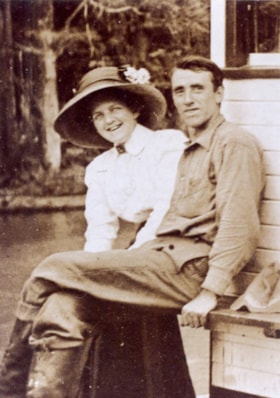
Jack and Sarah Waplington
https://search.heritageburnaby.ca/link/museumdescription5076
- Repository
- Burnaby Village Museum
- Date
- 1911
- Collection/Fonds
- Waplington family fonds
- Description Level
- Item
- Physical Description
- 1 photograph : col. copy print 13 x 9.5 cm
- Scope and Content
- Photograph of Jack and Sara Waplington who were married in 1911. Sarah is wearing a white blouse and a large hat with a floral corrsage on top while Jack is wearing a dark coloured shirt, pants and high topped boots. Both are seated outside an unidentified building.
- Repository
- Burnaby Village Museum
- Collection/Fonds
- Waplington family fonds
- Description Level
- Item
- Physical Description
- 1 photograph : col. copy print 13 x 9.5 cm
- Scope and Content
- Photograph of Jack and Sara Waplington who were married in 1911. Sarah is wearing a white blouse and a large hat with a floral corrsage on top while Jack is wearing a dark coloured shirt, pants and high topped boots. Both are seated outside an unidentified building.
- Geographic Access
- Deer Lake
- Deer Lake Avenue
- Accession Code
- BV016.46.53
- Access Restriction
- No restrictions
- Reproduction Restriction
- No known restrictions
- Date
- 1911
- Media Type
- Photograph
- Historic Neighbourhood
- Burnaby Lake (Historic Neighbourhood)
- Planning Study Area
- Morley-Buckingham Area
- Scan Resolution
- 600
- Scan Date
- 13-Aug-2018
- Notes
- Title based on contents of photograph
- Note in blue ink on verso of photograph reads: "Frances L's parents / Sara and Jack Waplington"
- Photograph is part of Photograph album BV016.46.52
Images
![Ladies at Fairacres, [1913] (date of original), copied 1978 thumbnail](/media/hpo/_Data/_BVM_Images/1977/197900340001.jpg?width=280)
Ladies at Fairacres
https://search.heritageburnaby.ca/link/museumdescription437
- Repository
- Burnaby Village Museum
- Date
- [1913] (date of original), copied 1978
- Collection/Fonds
- Burnaby Village Museum Photograph collection
- Description Level
- Item
- Physical Description
- 2 photographs : b&w ; 20.3 x 25.2 cm prints
- Scope and Content
- Photograph of a group of ladies standing in front of the Fairacres Mansion. Grace Ceperley is in the front, with one hand on her hip and the other hand holding a kerchief.
- Repository
- Burnaby Village Museum
- Collection/Fonds
- Burnaby Village Museum Photograph collection
- Description Level
- Item
- Physical Description
- 2 photographs : b&w ; 20.3 x 25.2 cm prints
- Scope and Content
- Photograph of a group of ladies standing in front of the Fairacres Mansion. Grace Ceperley is in the front, with one hand on her hip and the other hand holding a kerchief.
- Names
- Ceperley, Grace
- Geographic Access
- Deer Lake Avenue
- Street Address
- 6344 Deer Lake Avenue
- Accession Code
- HV979.34.1
- Access Restriction
- No restrictions
- Reproduction Restriction
- No known restrictions
- Date
- [1913] (date of original), copied 1978
- Media Type
- Photograph
- Historic Neighbourhood
- Burnaby Lake (Historic Neighbourhood)
- Planning Study Area
- Douglas-Gilpin Area
- Scan Resolution
- 600
- Scan Date
- 2023-09-12
- Notes
- Title based on contents of photograph
Images
![Ladies at Fairacres, [1913] (date of original), copied 1978 thumbnail](/media/hpo/_Data/_BVM_Images/1977/197900340001.jpg)
![Mathers house, [1912] (date of original), copied 1985 thumbnail](/media/hpo/_Data/_BVM_Images/1985/1985_0057_0001_001.jpg?width=280)
Mathers house
https://search.heritageburnaby.ca/link/museumdescription166
- Repository
- Burnaby Village Museum
- Date
- [1912] (date of original), copied 1985
- Collection/Fonds
- Burnaby Village Museum Photograph collection
- Description Level
- Item
- Physical Description
- 1 photograph : b&w ; 20.2 x 25.2 cm print
- Scope and Content
- Photograph of the Mathers house in 1912. There is a family (perhaps the W.J. Mathers family) sitting on the stone-walled patio. Note the electric power pole to the right side of the photograph located close to the house. The house is now part of the Deer Lake Park Complex and is used for various ar…
- Repository
- Burnaby Village Museum
- Collection/Fonds
- Burnaby Village Museum Photograph collection
- Description Level
- Item
- Physical Description
- 1 photograph : b&w ; 20.2 x 25.2 cm print
- Scope and Content
- Photograph of the Mathers house in 1912. There is a family (perhaps the W.J. Mathers family) sitting on the stone-walled patio. Note the electric power pole to the right side of the photograph located close to the house. The house is now part of the Deer Lake Park Complex and is used for various artistic and cultural activities. According to a note prepared by Kathleen and Eileen Mather, the house otherwise known as "Altnadene" was built in 1911-1912 for Mr. and Mrs. W.J. Mathers of New Westminster by architect F.W. Macey who lived on Douglas Road. The house was occupied by the family from late-1912 until mid-1935. The original photographs have been taken by professional photographers.
- Subjects
- Buildings - Residential - Houses
- Geographic Access
- Deer Lake Avenue
- Street Address
- 6490 Deer Lake Avenue
- Accession Code
- BV985.57.1
- Access Restriction
- No restrictions
- Reproduction Restriction
- No known restrictions
- Date
- [1912] (date of original), copied 1985
- Media Type
- Photograph
- Historic Neighbourhood
- Burnaby Lake (Historic Neighbourhood)
- Planning Study Area
- Douglas-Gilpin Area
- Scan Resolution
- 600
- Scan Date
- 2023-12-19
- Notes
- Title based on contents of photograph
Images
![Mathers house, [1912] (date of original), copied 1985 thumbnail](/media/hpo/_Data/_BVM_Images/1985/1985_0057_0001_001.jpg)
![Mathers house, [1913 or 1916] (date of original), copied 1985 thumbnail](/media/hpo/_Data/_BVM_Images/1985/1985_0057_0002_001.jpg?width=280)
Mathers house
https://search.heritageburnaby.ca/link/museumdescription167
- Repository
- Burnaby Village Museum
- Date
- [1913 or 1916] (date of original), copied 1985
- Collection/Fonds
- Burnaby Village Museum Photograph collection
- Description Level
- Item
- Physical Description
- 1 photograph : b&w ; 20.2 x 25.2 cm print
- Scope and Content
- Photograph of the Mathers house with two children on the stone-walled patio and a girl on the lawn. The house is now part of the Deer Lake Park Complex and is used for various artistic and cultural activities. According to a note prepared by Kathleen and Eileen Mathers, the house otherwise known as…
- Repository
- Burnaby Village Museum
- Collection/Fonds
- Burnaby Village Museum Photograph collection
- Description Level
- Item
- Physical Description
- 1 photograph : b&w ; 20.2 x 25.2 cm print
- Scope and Content
- Photograph of the Mathers house with two children on the stone-walled patio and a girl on the lawn. The house is now part of the Deer Lake Park Complex and is used for various artistic and cultural activities. According to a note prepared by Kathleen and Eileen Mathers, the house otherwise known as "Altnadene" was built in 1911-1912 for Mr. and Mrs. W.J. Mathers of New Westminster by architect F.W. Macey who lived on Douglas Road. The house was occupied by the family from late-1912 until mid-1935. he original photographs have been taken by professional photographers. The accession register dates the photograph ca. 1913 while the inscription dates it 1916. An annotation on the back of the photograph reads: "Altnadara [sic] 1916."
- Subjects
- Buildings - Residential - Houses
- Geographic Access
- Deer Lake Avenue
- Street Address
- 6490 Deer Lake Avenue
- Accession Code
- BV985.57.2
- Access Restriction
- No restrictions
- Reproduction Restriction
- No known restrictions
- Date
- [1913 or 1916] (date of original), copied 1985
- Media Type
- Photograph
- Historic Neighbourhood
- Burnaby Lake (Historic Neighbourhood)
- Planning Study Area
- Douglas-Gilpin Area
- Scan Resolution
- 600
- Scan Date
- 2023-12-19
- Notes
- Title based on contents of photograph
Images
![Mathers house, [1913 or 1916] (date of original), copied 1985 thumbnail](/media/hpo/_Data/_BVM_Images/1985/1985_0057_0002_001.jpg)
![Murdoch McMurray and his team of horses, [1911] (date of original), copied 1976 thumbnail](/media/hpo/_Data/_BVM_Images//1976/1976_0041_0003_001.jpg?width=280)
Murdoch McMurray and his team of horses
https://search.heritageburnaby.ca/link/museumdescription713
- Repository
- Burnaby Village Museum
- Date
- [1911] (date of original), copied 1976
- Collection/Fonds
- Burnaby Village Museum Photograph collection
- Description Level
- Item
- Physical Description
- 1 photograph : b&w ; 20.2 x 25.3 cm print
- Scope and Content
- Photograph of Murdoch McMurray driving a team of horses reined to a cart on Douglas Road, near Still Creek. An accompanying note identifies the photograph as: "Mr. McMurray with his first team of horses (picture was taken in 1911) hauling crushed rock on Douglas Road when it was being macadamized …
- Repository
- Burnaby Village Museum
- Collection/Fonds
- Burnaby Village Museum Photograph collection
- Description Level
- Item
- Physical Description
- 1 photograph : b&w ; 20.2 x 25.3 cm print
- Scope and Content
- Photograph of Murdoch McMurray driving a team of horses reined to a cart on Douglas Road, near Still Creek. An accompanying note identifies the photograph as: "Mr. McMurray with his first team of horses (picture was taken in 1911) hauling crushed rock on Douglas Road when it was being macadamized from 10th Ave. to Boundary Road. This portion of the road was near Still Creek. (Fred McPherson was Municipal Engineer at this time.)"
- Names
- McMurray, Murdoch
- Geographic Access
- Douglas Road
- Accession Code
- HV976.41.3
- Access Restriction
- No restrictions
- Reproduction Restriction
- May be restricted by third party rights
- Date
- [1911] (date of original), copied 1976
- Media Type
- Photograph
- Historic Neighbourhood
- Burnaby Lake (Historic Neighbourhood)
- Planning Study Area
- Dawson-Delta Area
- Ardingley-Sprott Area
- Scan Resolution
- 600
- Scan Date
- 2023-06-13
- Notes
- Title based on contents of photograph
Images
![Murdoch McMurray and his team of horses, [1911] (date of original), copied 1976 thumbnail](/media/hpo/_Data/_BVM_Images//1976/1976_0041_0003_001.jpg)
![Subdivision plans in New Westminster District Group 1 – Burnaby
, [1893-1910] thumbnail](/media/hpo/_Data/_BVM_Cartographic_Material/1977/1977_0093_0016a_001.jpg?width=280)
Subdivision plans in New Westminster District Group 1 – Burnaby
https://search.heritageburnaby.ca/link/museumdescription6985
- Repository
- Burnaby Village Museum
- Date
- [1893-1910]
- Collection/Fonds
- Burnaby Village Museum Map collection
- Description Level
- File
- Physical Description
- 4 plans : blueprint ink on paper mounted on 2 sides of cardboard 76 x 102 cm
- Scope and Content
- Item consists of a large board of two New Westminster District Gp 1 - subdivision plans mounted on one side and two New Westminster District Gp 1 - subdivision plans mounted on the other side. Side A: 1. Blueprint "Plan / of Subdivision / of / Lot 6 / Group One / New Westminster District / Scale…
- Repository
- Burnaby Village Museum
- Collection/Fonds
- Burnaby Village Museum Map collection
- Description Level
- File
- Physical Description
- 4 plans : blueprint ink on paper mounted on 2 sides of cardboard 76 x 102 cm
- Material Details
- Scales [between 1:1584 and 1:3960]
- Index number on edge of board reads: "16"
- Scope and Content
- Item consists of a large board of two New Westminster District Gp 1 - subdivision plans mounted on one side and two New Westminster District Gp 1 - subdivision plans mounted on the other side. Side A: 1. Blueprint "Plan / of Subdivision / of / Lot 6 / Group One / New Westminster District / Scale 5 chs = 1 in. / Map No 748" (Geographic location: Burnaby) 2. Blueprint "Plan / of Subdivision / of a Portion / of / Lot 29 / Group One / New Westminster Dist. / Scale 2 chs = 1 in. / Map No." Name identified in Block H is "Reichenbach" (Geographic location: Burnaby) Side B: 1. Blueprint "Plan / of Subdivision / of North 1/2 of Lot 80 / Group One / New Westminster District / Scale 3 chs = 1 in. / Map No 719" Plan is signed by: "Garden, Hermon & Burwell P.L.S. / Vancouver Jan. 23rd, 1893" (Geographic location: Burnaby) 2. Blueprint "Plan / of Subdivision / of Lot 79, Gr.1 / New Westminster Dist. / Scale 4 chas = 1 in. / Map No 536" Plan is signed by "Garden Hermon & Burwell / Provincial Land Surveyors". (Geographic location: Burnaby)
- Creator
- Garden, Hermon and Burwell
- Accession Code
- HV977.93.16
- Access Restriction
- No restrictions
- Reproduction Restriction
- No known restrictions
- Date
- [1893-1910]
- Media Type
- Cartographic Material
- Historic Neighbourhood
- Edmonds (Historic Neighbourhood)
- Burnaby Lake (Historic Neighbourhood)
- Planning Study Area
- Douglas-Gilpin Area
- Edmonds Area
- Cameron Area
- Scan Resolution
- 300
- Scale
- 72
- Notes
- Title based on contents of file
- Scale is measured in chains. (One chain equals 792 inches)
- The term "Lot" can also refer to a "District Lot”
Images
![Subdivision plans in New Westminster District Group 1 – Burnaby
, [1893-1910] thumbnail](/media/hpo/_Data/_BVM_Cartographic_Material/1977/1977_0093_0016a_001.jpg)

![Survey and Subdivision plans in New Westminster District Group 1 and Group 2 – Vancouver, ʷməθkʷəy̓əm (Musqueam) Indian Reserve, Burnaby, Surrey
, [1910-1911] thumbnail](/media/hpo/_Data/_BVM_Cartographic_Material/1977/1977_0093_0017_001.jpg?width=280)
Survey and Subdivision plans in New Westminster District Group 1 and Group 2 – Vancouver, ʷməθkʷəy̓əm (Musqueam) Indian Reserve, Burnaby, Surrey
https://search.heritageburnaby.ca/link/museumdescription6986
- Repository
- Burnaby Village Museum
- Date
- [1910-1911]
- Collection/Fonds
- Burnaby Village Museum Map collection
- Description Level
- File
- Physical Description
- 9 plans : 4 plans : blueprint ink on paper + 4 plans : black ink on paper + 1 plan : graphite on paper mounted on 2 sides of cardboard 76 x 102 cm
- Scope and Content
- File consists of a large board of three survey plans in New Westminster District Group 1 mounted on one side and six survey and subdivision plans of District Lot 85, New Westminster District Group 1 mounted on the other side. Side A: 1. Plan : blueprint on paper ; 30.5 x 80 cm. Title reads: "Fras…
- Repository
- Burnaby Village Museum
- Collection/Fonds
- Burnaby Village Museum Map collection
- Description Level
- File
- Physical Description
- 9 plans : 4 plans : blueprint ink on paper + 4 plans : black ink on paper + 1 plan : graphite on paper mounted on 2 sides of cardboard 76 x 102 cm
- Material Details
- Scales vary (One chain equals 792 inches)
- Indexed number on tape on edge of board reads "17"
- Scope and Content
- File consists of a large board of three survey plans in New Westminster District Group 1 mounted on one side and six survey and subdivision plans of District Lot 85, New Westminster District Group 1 mounted on the other side. Side A: 1. Plan : blueprint on paper ; 30.5 x 80 cm. Title reads: "Fraser River Bridge / Plan of South Approach". Plan covers area of land north of the Fraser River and Great Northern Railway with approach for a bridge running through the "ʷməθkʷəy̓əm (Musqueam) Indian Reserve" (ʷməθkʷəy̓əm (Musqueam) First Nation) and lots marked as Dominion Government and the east half of Lot 2 identified as "C. F. Brown" "Plan 851". Plan is identified as "Plan 851 / traced / Mar. 17, 1911". (Geographic location in Vancouver) Scale: 100 feet = 1 inch, Signed by Albert J. Hill / P.L.S." 2. Plan : blueprint on paper ; 36.5 x 35 cm (no title). Includes three plans of lots on the east and west sides of North Road. Note on bottom of blueprint reads: "I.E.B. McKay Surveyor General - hereby certify / that this is a correct tracing from the field / notes of the Royal Engineers on file in the / Lands Department / E.B. McKay (signature) / Surveyor General / Victoria B.C. April 11th 1911" . Plan in top left titled "Page 11 / Vol. 1. / R.E. Notes" covers District Lots east of North Road including Lot 5, Lot 7, Lot 41, Lot 9 and Lot 107 in Coquitlam. Plan in top right corner titled "Page 17 / Vol. 1. / R.E. Notes" covers District Lots east of North Road including Lot 104, Lot 54, Lot 105, Lot 55, Lot 106, Lot 9 and Lot 107 in Coquitlam and Port Moody. Plan in lower left corner titled "Page 15 / Vol. 1 / R.E. Notes" covers District Lots west of North Road including Lot 147, Lot 148, Lot 100, Lot 15 in Burnaby. 3. Plan : blue print on paper ; 29.5 x 41.5 cm. (no formal title). Plan of the North 1/2 of Section 18. Plan covers area in the "North 1/2 of Sec.18 B.5 N RGE 1 W" and "Sec. 18 B.5 N. RGE 1 W" bordered by Section 7, Section 13, Section 17 and Section 19. Bon Accord Road runs through Sec. 18. The plan is signed by surveryor "I.H. Neville Smith... C.E.B.C.L.S. / Mar. 26th 1910" and signed by "Ludwig Pillath". (Geographic location: Surrey) Side B: 1. Plan : blueprint on paper ; 43.5 x 49.5 cm. Title reads: "Plan / of Subdivision / of a Portion / of / Lot 85 / Group One / New Westminster District. Plan covers portion of land east of Deer Lake and Pole Line Road (Sperling Avenue) and south of Hastings Road in District Lot 85 in Burnaby with section 4 and a portion of section 2 coloured in red. Plan is signed by "Albert J. Hill, B.C.L.S." Plan is initialed by: "RB" [sic] (in blue pencil crayon) Scale: 4 chains = 1 inch 2. Plaln : black black ink on linen ; 39 x 37 cm. Title reads: "L.C. Hill's Property, / Burnaby". Plan covers a triangular portion of land east of Pole Line Road (Sperling Avenue) and south of Hastings Road in District Lot 85 in Burnaby. Plan is intitaled by "RB" [sic] (in blue pencil crayon). Scale: 3 chains = 1 mile 3. Plan : graphite on paper ; 23 x 17 cm. Title reads: "Portion of Lot 85 / Gr.1". Plan covers portion of land north east of Deer Lake and west of Pole Line Road (now Sperling Avenue) in District Lot 85 in Burnaby. Plan is stamped in red ink: "Albert J. Hill, Civil Engineer". Plan is initialed by: "RB" [sic] (in blue pencil crayon). Scale: 1 chain = 1 inch 4. Plan : black ink on linen ; 16 x 19 cm. Title reads: "Lot 85". Plan covers the intersection of Pole Line Road (Sperling Avenue) and Hastings Road at the north west section of District Lot 79 and District Lot 85 in Burnaby. Plan is stamped: "A.J. Hill, Civil Engineer" with identitifed in blue pencil crayon. 5. Plan : black ink on paper ; 28.5 x 37 cm. (no formal title) Plan covers an area of land, west of Pole Line Road (Sperling Avenue) and south of Deer Lake in District Lot 85 in Burnaby. Plan is initialed by: "RB" [sic] (in blue pencil crayon) 6. Plan : black ink on paper ; 21 x 34 cm (no formal title). Plan covers an area of land, west of Pole Line Road (Sperling Avenue) and south of Deer Lake in District Lot 85 in Burnaby. Plan is initialed by: "RB" [sic] (in blue pencil crayon)
- Accession Code
- HV977.93.17
- Access Restriction
- No restrictions
- Reproduction Restriction
- No known restrictions
- Date
- [1910-1911]
- Media Type
- Cartographic Material
- Historic Neighbourhood
- Burnaby Lake (Historic Neighbourhood)
- Burquitlam (Historic Neighbourhood)
- Planning Study Area
- Morley-Buckingham Area
- Douglas-Gilpin Area
- Scan Resolution
- 600
- Scan Date
- 2023-06-26
- Notes
- Title based on contents of file
- Scale is measured in chains and feet. (One chain equals 792 inches).
- The term "Lot" also refers to a "District Lot”
- Some plans are stamped: "Albert J. Hill, Civil Engineer / and / Provincial Land Surveyor, / New Westminster, / B.C." and intialed: "RB" [sic]
Zoomable Images
![Survey and Subdivision plans in New Westminster District Group 1 and Group 2 – Vancouver, ʷməθkʷəy̓əm (Musqueam) Indian Reserve, Burnaby, Surrey
, [1910-1911] thumbnail](/media/hpo/_Data/_BVM_Cartographic_Material/1977/1977_0093_0017_003_seadragon/1977_0093_0017_003.jpg?w=280)
Survey and Subdivision plans in New Westminster District Group 1 and Group 2 – Vancouver, ʷməθkʷəy̓əm (Musqueam) Indian Reserve, Burnaby, Surrey , [1910-1911]
Zoom into Image