Narrow Results By
Decade
- 2020s 2
- 2010s 24
- 2000s 200
- 1990s 527
- 1980s 906
- 1970s 1036
- 1960s 949
- 1950s 1016
- 1940s
- 1930s 1039
- 1920s 1295
- 1910s 899
- 1900s 295
- 1890s 105
- 1880s 21
- 1870s 13
- 1860s 13
- 1850s 7
- 1840s 5
- 1830s 4
- 1820s 4
- 1810s 3
- 1800s 3
- 1790s 2
- 1780s 2
- 1770s 2
- 1760s 2
- 1750s 2
- 1740s 2
- 1730s 2
- 1720s 2
- 1710s 2
- 1700s 2
- 1690s 2
- 1680s 2
- 1670s 1
- 1660s 1
- 1650s 1
- 1640s 1
- 1630s 1
- 1620s 1
- 1610s 1
- 1600s 1
- 1590s 1
- 1580s 1
- 1570s 1
- 1560s 1
- 1550s 1
- 1540s 1
- 1530s 1
- 1520s 1
- 1510s 1
- 1500s 1
- 1490s 1
- 1480s 1
Subject
- Accidents - Automobile Accidents 1
- Advertising Medium - Signs and Signboards 6
- Aerial Photographs 4
- Agricultural Tools and Equipment - Cultivators 1
- Agricultural Tools and Equipment - Gardening Equipment 1
- Agriculture - Farms 1
- Agriculture - Fruit and Berries 1
- Agriculture - Poultry 1
- Animals - Birds 1
- Animals - Cats 2
- Animals - Cows 1
- Animals - Dogs 26

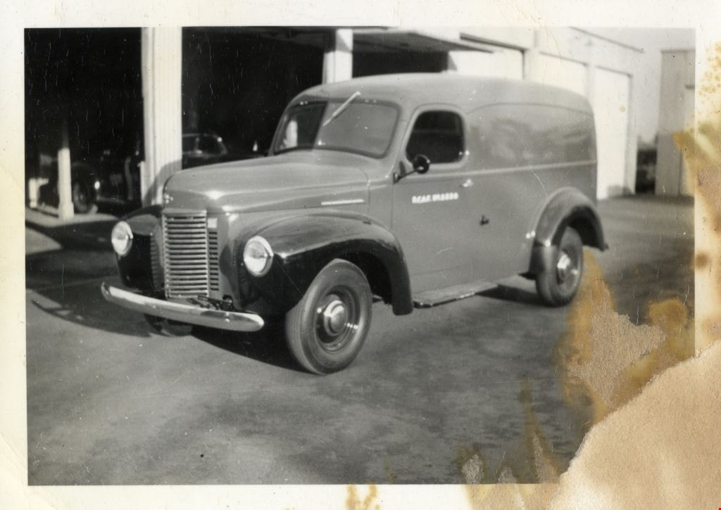
1941 International panel truck
https://search.heritageburnaby.ca/link/archivedescription63956
- Repository
- City of Burnaby Archives
- Date
- 1941
- Collection/Fonds
- Burnaby Historical Society fonds
- Description Level
- Item
- Physical Description
- 1 photograph : b&w ; 6.3 x 8.8 cm
- Scope and Content
- Photograph of a "new" 1941 International panel truck.
- Repository
- City of Burnaby Archives
- Date
- 1941
- Collection/Fonds
- Burnaby Historical Society fonds
- Subseries
- Bancroft family subseries
- Physical Description
- 1 photograph : b&w ; 6.3 x 8.8 cm
- Description Level
- Item
- Record No.
- 507-003
- Access Restriction
- No restrictions
- Reproduction Restriction
- No known restrictions
- Accession Number
- BHS2004-06
- Scope and Content
- Photograph of a "new" 1941 International panel truck.
- Subjects
- Transportation - Automobiles
- Media Type
- Photograph
- Notes
- Title based on contents of photograph
- Note in pencil on verso of photograph reads: "a new 1941 International panel that is stored here"
Images
1946 Data from the Burnaby Town Planning Commission
https://search.heritageburnaby.ca/link/archivedescription58085
- Repository
- City of Burnaby Archives
- Date
- 1946-1947
- Collection/Fonds
- Burnaby Historical Society fonds
- Description Level
- Item
- Physical Description
- 1 report
- Scope and Content
- Item is a report of "1946 Data from the Burnaby Town Planning Commission" compiled by H. Nolan MacPherson. ("MR. B.A. EAGLES" is written on the front cover underneath the title). Affixed to the inside back cover of the report are a series of maps, and loosely contained inside the report are two pap…
- Repository
- City of Burnaby Archives
- Date
- 1946-1947
- Collection/Fonds
- Burnaby Historical Society fonds
- Subseries
- Eagles family subseries
- Physical Description
- 1 report
- Description Level
- Item
- Record No.
- MSS055-036
- Accession Number
- BHS1991-18
- Scope and Content
- Item is a report of "1946 Data from the Burnaby Town Planning Commission" compiled by H. Nolan MacPherson. ("MR. B.A. EAGLES" is written on the front cover underneath the title). Affixed to the inside back cover of the report are a series of maps, and loosely contained inside the report are two papers - one is a letter introducing the report and the other is the agenda for the meeting at which the report would be discussed.
- Media Type
- Textual Record
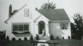
![2224 Antrim Avenue, [1940] (date of original), copied 1991 thumbnail](/media/hpo/_Data/_Archives_Images/_Unrestricted/370/370-602.jpg?width=280)
2224 Antrim Avenue
https://search.heritageburnaby.ca/link/archivedescription38015
- Repository
- City of Burnaby Archives
- Date
- [1940] (date of original), copied 1991
- Collection/Fonds
- Burnaby Historical Society fonds
- Description Level
- Item
- Physical Description
- 1 photograph : b&w ; 2.3 x 3.2 cm print on contact sheet 20.6 x 26.9 cm
- Scope and Content
- Photograph of the side of the house at 2224 Antrim Avenue (later renumbered 6957 Antrim Avenue).
- Repository
- City of Burnaby Archives
- Date
- [1940] (date of original), copied 1991
- Collection/Fonds
- Burnaby Historical Society fonds
- Subseries
- Burnaby Image Bank subseries
- Physical Description
- 1 photograph : b&w ; 2.3 x 3.2 cm print on contact sheet 20.6 x 26.9 cm
- Description Level
- Item
- Record No.
- 370-602
- Access Restriction
- No restrictions
- Reproduction Restriction
- No known restrictions
- Accession Number
- BHS1999-03
- Scope and Content
- Photograph of the side of the house at 2224 Antrim Avenue (later renumbered 6957 Antrim Avenue).
- Media Type
- Photograph
- Notes
- Title based on contents of photograph
- 1 b&w copy negative accompanying
- Negative has a pink cast
- Geographic Access
- Antrim Avenue
- Street Address
- 6957 Antrim Avenue
- Historic Neighbourhood
- Central Park (Historic Neighbourhood)
- Planning Study Area
- Windsor Area
Images
![2224 Antrim Avenue, [1940] (date of original), copied 1991 thumbnail](/media/hpo/_Data/_Archives_Images/_Unrestricted/370/370-602.jpg)
![2224 Antrim Avenue, [1940] (date of original), copied 1991 thumbnail](/media/hpo/_Data/_Archives_Images/_Unrestricted/370/370-603.jpg?width=280)
2224 Antrim Avenue
https://search.heritageburnaby.ca/link/archivedescription38016
- Repository
- City of Burnaby Archives
- Date
- [1940] (date of original), copied 1991
- Collection/Fonds
- Burnaby Historical Society fonds
- Description Level
- Item
- Physical Description
- 1 photograph : b&w ; 2.7 x 4.6 cm print on contact sheet 20.6 x 26.9 cm
- Scope and Content
- Photograph of the backyard of 2224 Antrim Avenue (later renumbered 6957 Antrim Avenue). A woman is standing in the yard.
- Repository
- City of Burnaby Archives
- Date
- [1940] (date of original), copied 1991
- Collection/Fonds
- Burnaby Historical Society fonds
- Subseries
- Burnaby Image Bank subseries
- Physical Description
- 1 photograph : b&w ; 2.7 x 4.6 cm print on contact sheet 20.6 x 26.9 cm
- Description Level
- Item
- Record No.
- 370-603
- Access Restriction
- No restrictions
- Reproduction Restriction
- No known restrictions
- Accession Number
- BHS1999-03
- Scope and Content
- Photograph of the backyard of 2224 Antrim Avenue (later renumbered 6957 Antrim Avenue). A woman is standing in the yard.
- Subjects
- Buildings - Residential - Houses
- Media Type
- Photograph
- Notes
- Title based on contents of photograph
- 1 b&w copy negative accompanying
- Negative has a pink cast
- Geographic Access
- Antrim Avenue
- Street Address
- 6957 Antrim Avenue
- Historic Neighbourhood
- Central Park (Historic Neighbourhood)
- Planning Study Area
- Windsor Area
Images
![2224 Antrim Avenue, [1940] (date of original), copied 1991 thumbnail](/media/hpo/_Data/_Archives_Images/_Unrestricted/370/370-603.jpg)
![2924 Silver Avenue, [1941] (date of original), copied 1991 thumbnail](/media/hpo/_Data/_Archives_Images/_Unrestricted/370/370-333.jpg?width=280)
2924 Silver Avenue
https://search.heritageburnaby.ca/link/archivedescription37745
- Repository
- City of Burnaby Archives
- Date
- [1941] (date of original), copied 1991
- Collection/Fonds
- Burnaby Historical Society fonds
- Description Level
- Item
- Physical Description
- 1 photograph : b&w ; 2.6 x 4.6 cm print on contact sheet 20.3 x 26.6 cm
- Scope and Content
- Photograph of 2924 Silver Ave (later renumbered 6113 Silver Avenue), taken form across the street.
- Repository
- City of Burnaby Archives
- Date
- [1941] (date of original), copied 1991
- Collection/Fonds
- Burnaby Historical Society fonds
- Subseries
- Burnaby Image Bank subseries
- Physical Description
- 1 photograph : b&w ; 2.6 x 4.6 cm print on contact sheet 20.3 x 26.6 cm
- Description Level
- Item
- Record No.
- 370-333
- Access Restriction
- No restrictions
- Reproduction Restriction
- No known restrictions
- Accession Number
- BHS1999-03
- Scope and Content
- Photograph of 2924 Silver Ave (later renumbered 6113 Silver Avenue), taken form across the street.
- Subjects
- Buildings - Residential - Houses
- Media Type
- Photograph
- Notes
- Title based on contents of photograph
- 1 b&w copy negative accompanying
- Negative has a pink cast
- Geographic Access
- Silver Avenue
- Street Address
- 6113 Silver Avenue
- Historic Neighbourhood
- Central Park (Historic Neighbourhood)
- Planning Study Area
- Maywood Area
Images
![2924 Silver Avenue, [1941] (date of original), copied 1991 thumbnail](/media/hpo/_Data/_Archives_Images/_Unrestricted/370/370-333.jpg)
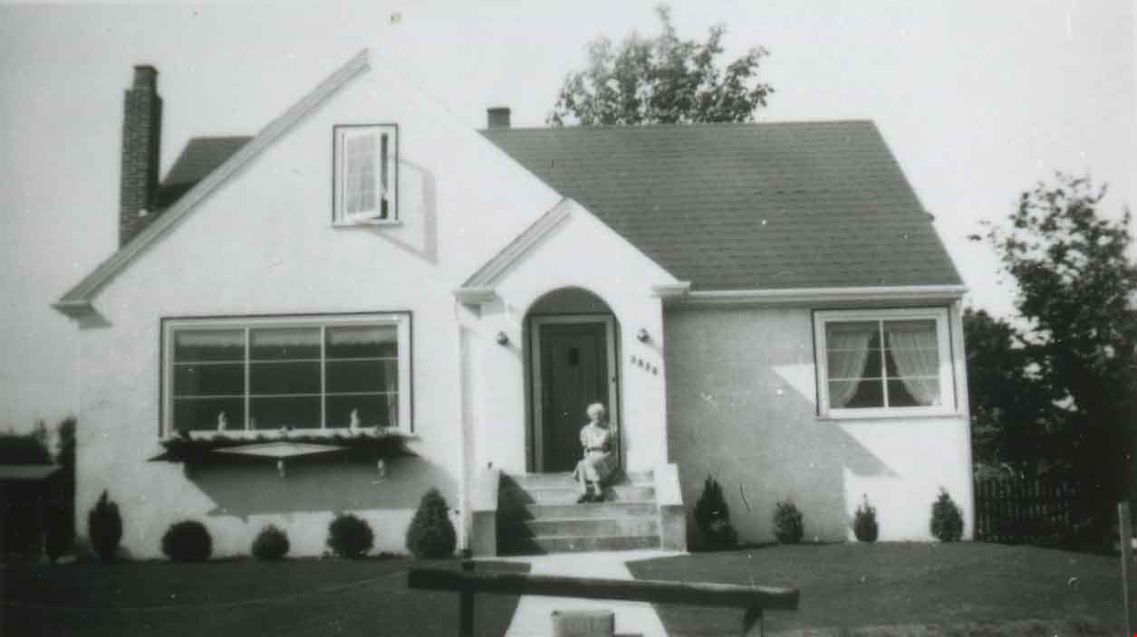
3830 Hazel Street
https://search.heritageburnaby.ca/link/archivedescription38159
- Repository
- City of Burnaby Archives
- Date
- 1945 (date of original), copied 1991
- Collection/Fonds
- Burnaby Historical Society fonds
- Description Level
- Item
- Physical Description
- 1 photograph : b&w ; 3.0 x 5.3 cm print on contact sheet 20.1 x 26.3 cm
- Scope and Content
- Photograph of 3830 Hazel Street (later renumbered 4662 Hazel Street) during the summer. A woman, probably Mrs. R.W. MacPhaden, is seated on the front steps.
- Repository
- City of Burnaby Archives
- Date
- 1945 (date of original), copied 1991
- Collection/Fonds
- Burnaby Historical Society fonds
- Subseries
- Burnaby Image Bank subseries
- Physical Description
- 1 photograph : b&w ; 3.0 x 5.3 cm print on contact sheet 20.1 x 26.3 cm
- Description Level
- Item
- Record No.
- 370-746
- Access Restriction
- No restrictions
- Reproduction Restriction
- No known restrictions
- Accession Number
- BHS1999-03
- Scope and Content
- Photograph of 3830 Hazel Street (later renumbered 4662 Hazel Street) during the summer. A woman, probably Mrs. R.W. MacPhaden, is seated on the front steps.
- Subjects
- Buildings - Residential - Houses
- Media Type
- Photograph
- Notes
- Title based on contents of photograph
- 1 b&w copy negative accompanying
- Negative has a pink cast
- Geographic Access
- Hazel Street
- Street Address
- 4662 Hazel Street
- Historic Neighbourhood
- Central Park (Historic Neighbourhood)
- Planning Study Area
- Marlborough Area
Images
![3830 Hazel Street, [ca. 1945] (date of original), copied 1991 thumbnail](/media/hpo/_Data/_Archives_Images/_Unrestricted/370/370-747.jpg?width=280)
3830 Hazel Street
https://search.heritageburnaby.ca/link/archivedescription38160
- Repository
- City of Burnaby Archives
- Date
- [ca. 1945] (date of original), copied 1991
- Collection/Fonds
- Burnaby Historical Society fonds
- Description Level
- Item
- Physical Description
- 1 photograph : b&w ; 3.0 x 5.4 cm print on contact sheet 20.1 x 26.3 cm
- Scope and Content
- Photograph of the view from 3830 Hazel Street (later renumbered 4662 Hazel Street) in the snow. Spud Murphy's car, a Desoto, can be seen in the street and the George family's house is in the background.
- Repository
- City of Burnaby Archives
- Date
- [ca. 1945] (date of original), copied 1991
- Collection/Fonds
- Burnaby Historical Society fonds
- Subseries
- Burnaby Image Bank subseries
- Physical Description
- 1 photograph : b&w ; 3.0 x 5.4 cm print on contact sheet 20.1 x 26.3 cm
- Description Level
- Item
- Record No.
- 370-747
- Access Restriction
- No restrictions
- Reproduction Restriction
- No known restrictions
- Accession Number
- BHS1999-03
- Scope and Content
- Photograph of the view from 3830 Hazel Street (later renumbered 4662 Hazel Street) in the snow. Spud Murphy's car, a Desoto, can be seen in the street and the George family's house is in the background.
- Media Type
- Photograph
- Notes
- Title based on contents of photograph
- 1 b&w copy negative accompanying
- Negative has a pink cast
- Geographic Access
- Hazel Street
- Street Address
- 4662 Hazel Street
- Historic Neighbourhood
- Central Park (Historic Neighbourhood)
- Planning Study Area
- Marlborough Area
Images
![3830 Hazel Street, [ca. 1945] (date of original), copied 1991 thumbnail](/media/hpo/_Data/_Archives_Images/_Unrestricted/370/370-747.jpg)
![4200 Block Cambridge Street, [1940] (date of original), copied 1991 thumbnail](/media/hpo/_Data/_Archives_Images/_Unrestricted/370/370-408.jpg?width=280)
4200 Block Cambridge Street
https://search.heritageburnaby.ca/link/archivedescription37820
- Repository
- City of Burnaby Archives
- Date
- [1940] (date of original), copied 1991
- Collection/Fonds
- Burnaby Historical Society fonds
- Description Level
- Item
- Physical Description
- 1 photograph : b&w ; 3.9 x 2.6 cm print on contact sheet 20.3 x 26.4 cm
- Scope and Content
- Photograph of a dog on the sidewalk of the 4200 block of Cambridge Street. The photograph was taken facing east, and Capitol Hill is visible in the background.
- Repository
- City of Burnaby Archives
- Date
- [1940] (date of original), copied 1991
- Collection/Fonds
- Burnaby Historical Society fonds
- Subseries
- Burnaby Image Bank subseries
- Physical Description
- 1 photograph : b&w ; 3.9 x 2.6 cm print on contact sheet 20.3 x 26.4 cm
- Description Level
- Item
- Record No.
- 370-408
- Access Restriction
- No restrictions
- Reproduction Restriction
- No known restrictions
- Accession Number
- BHS1999-03
- Scope and Content
- Photograph of a dog on the sidewalk of the 4200 block of Cambridge Street. The photograph was taken facing east, and Capitol Hill is visible in the background.
- Media Type
- Photograph
- Notes
- Title based on contents of photograph
- 1 b&w copy negative accompanying
- Negative has a pink cast
- Geographic Access
- Cambridge Street
- Historic Neighbourhood
- Vancouver Heights (Historic Neighbourhood)
- Planning Study Area
- Burnaby Heights Area
Images
![4200 Block Cambridge Street, [1940] (date of original), copied 1991 thumbnail](/media/hpo/_Data/_Archives_Images/_Unrestricted/370/370-408.jpg)
![4200 Block Cambridge Street, [1940] (date of original), copied 1991 thumbnail](/media/hpo/_Data/_Archives_Images/_Unrestricted/370/370-409.jpg?width=280)
4200 Block Cambridge Street
https://search.heritageburnaby.ca/link/archivedescription37821
- Repository
- City of Burnaby Archives
- Date
- [1940] (date of original), copied 1991
- Collection/Fonds
- Burnaby Historical Society fonds
- Description Level
- Item
- Physical Description
- 1 photograph : b&w ; 3.9 x 2.6 cm print on contact sheet 20.3 x 26.4 cm
- Scope and Content
- Photograph of a dog sitting beside the sidewalk on the 4200 block of Cambridge Street.
- Repository
- City of Burnaby Archives
- Date
- [1940] (date of original), copied 1991
- Collection/Fonds
- Burnaby Historical Society fonds
- Subseries
- Burnaby Image Bank subseries
- Physical Description
- 1 photograph : b&w ; 3.9 x 2.6 cm print on contact sheet 20.3 x 26.4 cm
- Description Level
- Item
- Record No.
- 370-409
- Access Restriction
- No restrictions
- Reproduction Restriction
- No known restrictions
- Accession Number
- BHS1999-03
- Scope and Content
- Photograph of a dog sitting beside the sidewalk on the 4200 block of Cambridge Street.
- Subjects
- Animals - Dogs
- Media Type
- Photograph
- Notes
- Title based on contents of photograph
- 1 b&w copy negative accompanying
- Negative has a pink cast
- Geographic Access
- Cambridge Street
- Historic Neighbourhood
- Vancouver Heights (Historic Neighbourhood)
- Planning Study Area
- Burnaby Heights Area
Images
![4200 Block Cambridge Street, [1940] (date of original), copied 1991 thumbnail](/media/hpo/_Data/_Archives_Images/_Unrestricted/370/370-409.jpg)
![4200 Block Cambridge Street, [ca. 1940] (date of original), copied 1991 thumbnail](/media/hpo/_Data/_Archives_Images/_Unrestricted/370/370-410.jpg?width=280)
4200 Block Cambridge Street
https://search.heritageburnaby.ca/link/archivedescription37822
- Repository
- City of Burnaby Archives
- Date
- [ca. 1940] (date of original), copied 1991
- Collection/Fonds
- Burnaby Historical Society fonds
- Description Level
- Item
- Physical Description
- 1 photograph : b&w ; 3.9 x 2.6 cm print on contact sheet 20.3 x 26.4 cm
- Scope and Content
- Photograph of a dog standing beside the sidewalk on the 4200 block of Cambridge Street. The back of a car can be seen on the right, and the road can be seen in the background.
- Repository
- City of Burnaby Archives
- Date
- [ca. 1940] (date of original), copied 1991
- Collection/Fonds
- Burnaby Historical Society fonds
- Subseries
- Burnaby Image Bank subseries
- Physical Description
- 1 photograph : b&w ; 3.9 x 2.6 cm print on contact sheet 20.3 x 26.4 cm
- Description Level
- Item
- Record No.
- 370-410
- Access Restriction
- No restrictions
- Reproduction Restriction
- No known restrictions
- Accession Number
- BHS1999-03
- Scope and Content
- Photograph of a dog standing beside the sidewalk on the 4200 block of Cambridge Street. The back of a car can be seen on the right, and the road can be seen in the background.
- Subjects
- Animals - Dogs
- Media Type
- Photograph
- Notes
- Title based on contents of photograph
- 1 b&w copy negative accompanying
- Negative has a pink cast
- Geographic Access
- Cambridge Street
- Historic Neighbourhood
- Vancouver Heights (Historic Neighbourhood)
- Planning Study Area
- Burnaby Heights Area
Images
![4200 Block Cambridge Street, [ca. 1940] (date of original), copied 1991 thumbnail](/media/hpo/_Data/_Archives_Images/_Unrestricted/370/370-410.jpg)
![5165 Sperling Avenue construction, [1941 or 1942] (date of original), copied 1991 thumbnail](/media/hpo/_Data/_Archives_Images/_Unrestricted/370/370-550.jpg?width=280)
5165 Sperling Avenue construction
https://search.heritageburnaby.ca/link/archivedescription37963
- Repository
- City of Burnaby Archives
- Date
- [1941 or 1942] (date of original), copied 1991
- Collection/Fonds
- Burnaby Historical Society fonds
- Description Level
- Item
- Physical Description
- 1 photograph : b&w ; 2.6 x 3.7 cm print on contact sheet 20.7 x 26.2 cm
- Scope and Content
- Photograph of the house of the Montague Moore family under construction at 5165 Sperling Avenue.
- Repository
- City of Burnaby Archives
- Date
- [1941 or 1942] (date of original), copied 1991
- Collection/Fonds
- Burnaby Historical Society fonds
- Subseries
- Burnaby Image Bank subseries
- Physical Description
- 1 photograph : b&w ; 2.6 x 3.7 cm print on contact sheet 20.7 x 26.2 cm
- Description Level
- Item
- Record No.
- 370-550
- Access Restriction
- No restrictions
- Reproduction Restriction
- No known restrictions
- Accession Number
- BHS1999-03
- Scope and Content
- Photograph of the house of the Montague Moore family under construction at 5165 Sperling Avenue.
- Media Type
- Photograph
- Notes
- Title based on contents of photograph
- 1 b&w copy negative accompanying
- Geographic Access
- Sperling Avenue
- Street Address
- 5165 Sperling Avenue
- Historic Neighbourhood
- Burnaby Lake (Historic Neighbourhood)
- Planning Study Area
- Morley-Buckingham Area
Images
![5165 Sperling Avenue construction, [1941 or 1942] (date of original), copied 1991 thumbnail](/media/hpo/_Data/_Archives_Images/_Unrestricted/370/370-550.jpg)
![5165 Sperling Avenue construction, [1941 or 1942] (date of original), copied 1991 thumbnail](/media/hpo/_Data/_Archives_Images/_Unrestricted/370/370-551.jpg?width=280)
5165 Sperling Avenue construction
https://search.heritageburnaby.ca/link/archivedescription37964
- Repository
- City of Burnaby Archives
- Date
- [1941 or 1942] (date of original), copied 1991
- Collection/Fonds
- Burnaby Historical Society fonds
- Description Level
- Item
- Physical Description
- 1 photograph : b&w ; 2.6 x 3.7 cm print on contact sheet 20.7 x 26.2 cm
- Scope and Content
- Photograph of the house of the Montague Moore family under construction at 5165 Sperling Avenue. Other houses on the street can be seen to the right, and the road can be seen in the foreground.
- Repository
- City of Burnaby Archives
- Date
- [1941 or 1942] (date of original), copied 1991
- Collection/Fonds
- Burnaby Historical Society fonds
- Subseries
- Burnaby Image Bank subseries
- Physical Description
- 1 photograph : b&w ; 2.6 x 3.7 cm print on contact sheet 20.7 x 26.2 cm
- Description Level
- Item
- Record No.
- 370-551
- Access Restriction
- No restrictions
- Reproduction Restriction
- No known restrictions
- Accession Number
- BHS1999-03
- Scope and Content
- Photograph of the house of the Montague Moore family under construction at 5165 Sperling Avenue. Other houses on the street can be seen to the right, and the road can be seen in the foreground.
- Media Type
- Photograph
- Notes
- Title based on contents of photograph
- 1 b&w copy negative accompanying
- Geographic Access
- Sperling Avenue
- Street Address
- 5165 Sperling Avenue
- Historic Neighbourhood
- Burnaby Lake (Historic Neighbourhood)
- Planning Study Area
- Morley-Buckingham Area
Images
![5165 Sperling Avenue construction, [1941 or 1942] (date of original), copied 1991 thumbnail](/media/hpo/_Data/_Archives_Images/_Unrestricted/370/370-551.jpg)
![6100 Block Kathleen Avenue, [1943 or 1944] (date of original), copied 1991 thumbnail](/media/hpo/_Data/_Archives_Images/_Unrestricted/370/370-241.jpg?width=280)
6100 Block Kathleen Avenue
https://search.heritageburnaby.ca/link/archivedescription37653
- Repository
- City of Burnaby Archives
- Date
- [1943 or 1944] (date of original), copied 1991
- Collection/Fonds
- Burnaby Historical Society fonds
- Description Level
- Item
- Physical Description
- 1 photograph : b&w ; 3.1 x 4.5 cm print on contact sheet 20.2 x 25.3 cm
- Scope and Content
- Photograph taken looking north on Kathleen Avenue from the 6100 block of Kathleen Avenue after a snowfall.
- Repository
- City of Burnaby Archives
- Date
- [1943 or 1944] (date of original), copied 1991
- Collection/Fonds
- Burnaby Historical Society fonds
- Subseries
- Burnaby Image Bank subseries
- Physical Description
- 1 photograph : b&w ; 3.1 x 4.5 cm print on contact sheet 20.2 x 25.3 cm
- Description Level
- Item
- Record No.
- 370-241
- Access Restriction
- No restrictions
- Reproduction Restriction
- No known restrictions
- Accession Number
- BHS1999-03
- Scope and Content
- Photograph taken looking north on Kathleen Avenue from the 6100 block of Kathleen Avenue after a snowfall.
- Media Type
- Photograph
- Notes
- Title based on contents of photograph
- 1 b&w copy negative accompanying
- Negative has a pink cast
- Geographic Access
- Kathleen Avenue
- Historic Neighbourhood
- Central Park (Historic Neighbourhood)
- Planning Study Area
- Maywood Area
Images
![6100 Block Kathleen Avenue, [1943 or 1944] (date of original), copied 1991 thumbnail](/media/hpo/_Data/_Archives_Images/_Unrestricted/370/370-241.jpg)
![6113 Silver Avenue, [between 1945 and 1949] (date of original), copied 1991 thumbnail](/media/hpo/_Data/_Archives_Images/_Unrestricted/370/370-357.jpg?width=280)
6113 Silver Avenue
https://search.heritageburnaby.ca/link/archivedescription37769
- Repository
- City of Burnaby Archives
- Date
- [between 1945 and 1949] (date of original), copied 1991
- Collection/Fonds
- Burnaby Historical Society fonds
- Description Level
- Item
- Physical Description
- 1 photograph : b&w ; 2.7 x 3.9 cm print on contact sheet 20.3 x 26.2 cm
- Scope and Content
- Photograph of 6113 Silver Avenue, the Ellis family home, in the snow.
- Repository
- City of Burnaby Archives
- Date
- [between 1945 and 1949] (date of original), copied 1991
- Collection/Fonds
- Burnaby Historical Society fonds
- Subseries
- Burnaby Image Bank subseries
- Physical Description
- 1 photograph : b&w ; 2.7 x 3.9 cm print on contact sheet 20.3 x 26.2 cm
- Description Level
- Item
- Record No.
- 370-357
- Access Restriction
- No restrictions
- Reproduction Restriction
- No known restrictions
- Accession Number
- BHS1999-03
- Scope and Content
- Photograph of 6113 Silver Avenue, the Ellis family home, in the snow.
- Media Type
- Photograph
- Notes
- Title based on contents of photograph
- 1 b&w copy negative accompanying
- Negative has a pink cast
- Geographic Access
- Silver Avenue
- Street Address
- 6113 Silver Avenue
- Historic Neighbourhood
- Central Park (Historic Neighbourhood)
- Planning Study Area
- Maywood Area
Images
![6113 Silver Avenue, [between 1945 and 1949] (date of original), copied 1991 thumbnail](/media/hpo/_Data/_Archives_Images/_Unrestricted/370/370-357.jpg)
![6113 Silver Avenue, [1948 or 1949] (date of original), copied 1991 thumbnail](/media/hpo/_Data/_Archives_Images/_Unrestricted/370/370-369.jpg?width=280)
6113 Silver Avenue
https://search.heritageburnaby.ca/link/archivedescription37781
- Repository
- City of Burnaby Archives
- Date
- [1948 or 1949] (date of original), copied 1991
- Collection/Fonds
- Burnaby Historical Society fonds
- Description Level
- Item
- Physical Description
- 1 photograph : b&w ; 2.8 x 4.2 cm print on contact sheet 20.3 x 27.0 cm
- Scope and Content
- Photograph of fire damage at the side of 6113 Silver Avenue, the Ellis family home. A ladder is leaning against the side of the house, and a person can be seen in the window.
- Repository
- City of Burnaby Archives
- Date
- [1948 or 1949] (date of original), copied 1991
- Collection/Fonds
- Burnaby Historical Society fonds
- Subseries
- Burnaby Image Bank subseries
- Physical Description
- 1 photograph : b&w ; 2.8 x 4.2 cm print on contact sheet 20.3 x 27.0 cm
- Description Level
- Item
- Record No.
- 370-369
- Access Restriction
- No restrictions
- Reproduction Restriction
- No known restrictions
- Accession Number
- BHS1999-03
- Scope and Content
- Photograph of fire damage at the side of 6113 Silver Avenue, the Ellis family home. A ladder is leaning against the side of the house, and a person can be seen in the window.
- Subjects
- Buildings - Residential - Houses
- Media Type
- Photograph
- Notes
- Title based on contents of photograph
- 1 b&w copy negative accompanying
- Negative has a pink cast
- Geographic Access
- Silver Avenue
- Street Address
- 6113 Silver Avenue
- Historic Neighbourhood
- Central Park (Historic Neighbourhood)
- Planning Study Area
- Maywood Area
Images
![6113 Silver Avenue, [1948 or 1949] (date of original), copied 1991 thumbnail](/media/hpo/_Data/_Archives_Images/_Unrestricted/370/370-369.jpg)
![6113 Silver Avenue addition, [1947] (date of original), copied 1991 thumbnail](/media/hpo/_Data/_Archives_Images/_Unrestricted/370/370-367.jpg?width=280)
6113 Silver Avenue addition
https://search.heritageburnaby.ca/link/archivedescription37779
- Repository
- City of Burnaby Archives
- Date
- [1947] (date of original), copied 1991
- Collection/Fonds
- Burnaby Historical Society fonds
- Description Level
- Item
- Physical Description
- 1 photograph : b&w ; 2.5 x 3.6 cm print on contact sheet 20.3 x 26.2 cm
- Scope and Content
- Photograph of the construction of an addition to 6113 Silver Avenue, the Ellis family home. Three people are sitting on the roof of the house.
- Repository
- City of Burnaby Archives
- Date
- [1947] (date of original), copied 1991
- Collection/Fonds
- Burnaby Historical Society fonds
- Subseries
- Burnaby Image Bank subseries
- Physical Description
- 1 photograph : b&w ; 2.5 x 3.6 cm print on contact sheet 20.3 x 26.2 cm
- Description Level
- Item
- Record No.
- 370-367
- Access Restriction
- No restrictions
- Reproduction Restriction
- No known restrictions
- Accession Number
- BHS1999-03
- Scope and Content
- Photograph of the construction of an addition to 6113 Silver Avenue, the Ellis family home. Three people are sitting on the roof of the house.
- Media Type
- Photograph
- Notes
- Title based on contents of photograph
- 1 b&w copy negative accompanying
- Negative has a pink cast
- Geographic Access
- Silver Avenue
- Street Address
- 6113 Silver Avenue
- Historic Neighbourhood
- Central Park (Historic Neighbourhood)
- Planning Study Area
- Maywood Area
Images
![6113 Silver Avenue addition, [1947] (date of original), copied 1991 thumbnail](/media/hpo/_Data/_Archives_Images/_Unrestricted/370/370-367.jpg)
![6113 Silver Avenue addition, [1947] (date of original), copied 1991 thumbnail](/media/hpo/_Data/_Archives_Images/_Unrestricted/370/370-368.jpg?width=280)
6113 Silver Avenue addition
https://search.heritageburnaby.ca/link/archivedescription37780
- Repository
- City of Burnaby Archives
- Date
- [1947] (date of original), copied 1991
- Collection/Fonds
- Burnaby Historical Society fonds
- Description Level
- Item
- Physical Description
- 1 photograph : b&w ; 2.5 x 3.6 cm print on contact sheet 20.3 x 26.2 cm
- Scope and Content
- Photograpm of the completed construction of an addition to 6113 Silver Avenue, the Ellis family home. Another house and car can be seen to the left.
- Repository
- City of Burnaby Archives
- Date
- [1947] (date of original), copied 1991
- Collection/Fonds
- Burnaby Historical Society fonds
- Subseries
- Burnaby Image Bank subseries
- Physical Description
- 1 photograph : b&w ; 2.5 x 3.6 cm print on contact sheet 20.3 x 26.2 cm
- Description Level
- Item
- Record No.
- 370-368
- Access Restriction
- No restrictions
- Reproduction Restriction
- No known restrictions
- Accession Number
- BHS1999-03
- Scope and Content
- Photograpm of the completed construction of an addition to 6113 Silver Avenue, the Ellis family home. Another house and car can be seen to the left.
- Media Type
- Photograph
- Notes
- Title based on contents of photograph
- 1 b&w copy negative accompanying
- Negative has a pink cast
- Geographic Access
- Silver Avenue
- Street Address
- 6113 Silver Avenue
- Historic Neighbourhood
- Central Park (Historic Neighbourhood)
- Planning Study Area
- Maywood Area
Images
![6113 Silver Avenue addition, [1947] (date of original), copied 1991 thumbnail](/media/hpo/_Data/_Archives_Images/_Unrestricted/370/370-368.jpg)
![6595 Deer Lake Drive, [1948] (date of original), copied 1991 thumbnail](/media/hpo/_Data/_Archives_Images/_Unrestricted/370/370-565.jpg?width=280)
6595 Deer Lake Drive
https://search.heritageburnaby.ca/link/archivedescription37978
- Repository
- City of Burnaby Archives
- Date
- [1948] (date of original), copied 1991
- Collection/Fonds
- Burnaby Historical Society fonds
- Description Level
- Item
- Physical Description
- 1 photograph : b&w ; 2.7 x 4.8 cm print on contact sheet 20.7 x 26.2 cm
- Scope and Content
- Photograph of a house at 6595 Deer Lake Drive. Deer Lake can be seen in the background
- Repository
- City of Burnaby Archives
- Date
- [1948] (date of original), copied 1991
- Collection/Fonds
- Burnaby Historical Society fonds
- Subseries
- Burnaby Image Bank subseries
- Physical Description
- 1 photograph : b&w ; 2.7 x 4.8 cm print on contact sheet 20.7 x 26.2 cm
- Description Level
- Item
- Record No.
- 370-565
- Access Restriction
- No restrictions
- Reproduction Restriction
- No known restrictions
- Accession Number
- BHS1999-03
- Scope and Content
- Photograph of a house at 6595 Deer Lake Drive. Deer Lake can be seen in the background
- Subjects
- Buildings - Residential - Houses
- Media Type
- Photograph
- Notes
- Title based on contents of photograph
- 1 b&w copy negative accompanying
- Geographic Access
- Deer Lake
- Deer Lake Drive
- Street Address
- 6595 Deer Lake Drive
- Historic Neighbourhood
- Burnaby Lake (Historic Neighbourhood)
- Planning Study Area
- Morley-Buckingham Area
Images
![6595 Deer Lake Drive, [1948] (date of original), copied 1991 thumbnail](/media/hpo/_Data/_Archives_Images/_Unrestricted/370/370-565.jpg)

6671 Halifax Street
https://search.heritageburnaby.ca/link/archivedescription97965
- Repository
- City of Burnaby Archives
- Date
- 1946
- Collection/Fonds
- Burnaby Historical Society fonds
- Description Level
- Item
- Physical Description
- 1 photograph : b&w. ; 7 cm x 12 cm
- Scope and Content
- Photograph of the newly-built Easthope family house at 6671 Halifax Street.
- Repository
- City of Burnaby Archives
- Date
- 1946
- Collection/Fonds
- Burnaby Historical Society fonds
- Subseries
- Easthope family subseries
- Physical Description
- 1 photograph : b&w. ; 7 cm x 12 cm
- Description Level
- Item
- Record No.
- 451-032
- Access Restriction
- No restrictions
- Reproduction Restriction
- No restrictions
- Accession Number
- BHS2003-06
- Scope and Content
- Photograph of the newly-built Easthope family house at 6671 Halifax Street.
- Subjects
- Buildings - Residential - Houses
- Media Type
- Photograph
- Notes
- Title based on contents of photograph
- Note in black ink on verso of photograph reads: "6671 Halifax St. 1946"
- Geographic Access
- Halifax Street
- Street Address
- 6671 Halifax Street
- Historic Neighbourhood
- Lochdale (Historic Neighbourhood)
- Planning Study Area
- Lochdale Area
Images

6711 Somers Street, Lochdale
https://search.heritageburnaby.ca/link/archivedescription63165
- Repository
- City of Burnaby Archives
- Date
- July 26, 1943
- Collection/Fonds
- Burnaby Historical Society fonds
- Description Level
- Item
- Physical Description
- 1 architectural floor plan : ink on tracing paper ; 25 x 31.5 cm
- Scope and Content
- Item is an architectural floor plan of the house at 6711 Somers Street in Lochdale, District Lot 132 Block 137. This lot was the property of George and Dorothy May Easthope (later renamed 6711 Halifax Street).
- Repository
- City of Burnaby Archives
- Date
- July 26, 1943
- Collection/Fonds
- Burnaby Historical Society fonds
- Subseries
- Easthope family subseries
- Physical Description
- 1 architectural floor plan : ink on tracing paper ; 25 x 31.5 cm
- Description Level
- Item
- Record No.
- MSS105-001
- Accession Number
- BHS2003-06
- Scope and Content
- Item is an architectural floor plan of the house at 6711 Somers Street in Lochdale, District Lot 132 Block 137. This lot was the property of George and Dorothy May Easthope (later renamed 6711 Halifax Street).
- Media Type
- Textual Record