Narrow Results By
Decade
- 2020s 153
- 2010s 211
- 2000s 241
- 1990s 653
- 1980s 612
- 1970s 1011
- 1960s 313
- 1950s 393
- 1940s 580
- 1930s 547
- 1920s 482
- 1910s 484
- 1900s 407
- 1890s
- 1880s 26
- 1870s 14
- 1860s 12
- 1850s 5
- 1840s 3
- 1830s 3
- 1820s 3
- 1810s 3
- 1800s
- 1790s 3
- 1780s 3
- 1770s 3
- 1760s 3
- 1750s 3
- 1740s 3
- 1730s 3
- 1720s 3
- 1710s 3
- 1700s 3
- 1690s 3
- 1680s 3
- 1670s 3
- 1660s 3
- 1650s 3
- 1640s 3
- 1630s 3
- 1620s 3
- 1610s 3
- 1600s 3
- 1520s 1
Subject
- Adornment - Jewelry 2
- Agriculture - Farms 1
- Buildings - Commercial - Grocery Stores 1
- Buildings - Commercial - Stores 1
- Buildings Components - Fireplaces 1
- Buildings - Heritage 1
- Buildings - Industrial - Factories 1
- Buildings - Industrial - Saw Mills 1
- Buildings - Residential - Houses 4
- Celebrations - Jubilee 1
- Ceremonies - Graduations 1
- Clothing 5
![Soldiers and nurse in front of a military tent, [1899 or 1900] thumbnail](/media/hpo/_Data/_BVM_Images/1974/197400470041.jpg?width=280)
Soldiers and nurse in front of a military tent
https://search.heritageburnaby.ca/link/museumdescription3059
- Repository
- Burnaby Village Museum
- Date
- [1899 or 1900]
- Collection/Fonds
- Burnaby Village Museum Photograph collection
- Description Level
- Item
- Physical Description
- 1 photograph : b&w ; 7.0 x 10.0 cm mounted on cardboard 12.6 x 15.9 cm
- Scope and Content
- Photograph of a group of unidentified soliders and an unidentified nurse standing in front of a military tent. Three men are seated on a bench, and three other men are standing behind them. One of the standing men is wounded and holding himself on crutches. An number "15" is in front of the tent…
- Repository
- Burnaby Village Museum
- Collection/Fonds
- Burnaby Village Museum Photograph collection
- Description Level
- Item
- Physical Description
- 1 photograph : b&w ; 7.0 x 10.0 cm mounted on cardboard 12.6 x 15.9 cm
- Scope and Content
- Photograph of a group of unidentified soliders and an unidentified nurse standing in front of a military tent. Three men are seated on a bench, and three other men are standing behind them. One of the standing men is wounded and holding himself on crutches. An number "15" is in front of the tent. According to the gift form signed by the donor, the photograph is thought to be taken in South Africa when when H. Niebergall was serving there.
- Accession Code
- HV974.47.41
- Access Restriction
- No restrictions
- Reproduction Restriction
- No known restrictions
- Date
- [1899 or 1900]
- Media Type
- Photograph
- Scan Resolution
- 600
- Scan Date
- 2023-04-25
- Notes
- Title based on contents of photograph
Images
![Soldiers and nurse in front of a military tent, [1899 or 1900] thumbnail](/media/hpo/_Data/_BVM_Images/1974/197400470041.jpg)
Leonard Love
https://search.heritageburnaby.ca/link/museumdescription9861
- Repository
- Burnaby Village Museum
- Date
- 1899 (date of original)-2008
- Collection/Fonds
- Burnaby Village Museum fonds
- Description Level
- File
- Physical Description
- 2 cm of textual records
- Scope and Content
- File consists of vital statistical, biographical and historical information about Leonard Love and family. Records include copies of vital statistics, interview notes, a newspaper clipping on the BC Society of Model Engineers at BVM, correspondence from descendents of Leonard Love and their memori…
- Repository
- Burnaby Village Museum
- Collection/Fonds
- Burnaby Village Museum fonds
- Series
- Jesse Love farmhouse series
- Subseries
- Love farmhouse research files subseries
- Description Level
- File
- Physical Description
- 2 cm of textual records
- Scope and Content
- File consists of vital statistical, biographical and historical information about Leonard Love and family. Records include copies of vital statistics, interview notes, a newspaper clipping on the BC Society of Model Engineers at BVM, correspondence from descendents of Leonard Love and their memories of the Love family and time spent in the farmhouse and an obituary for Gordon Wesley Love. Leonard Love was born in 1899, married Jenny Kennedy in 1922 and is the son of Jesse Love and Martha Love (nee Leonard).
- Names
- Love, John Leonard
- Accession Code
- BV018.41.72
- Access Restriction
- Subject to FIPPA
- Reproduction Restriction
- Reproductions subject to FIPPA
- Date
- 1899 (date of original)-2008
- Media Type
- Textual Record
- Notes
- Title based on content of file
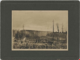
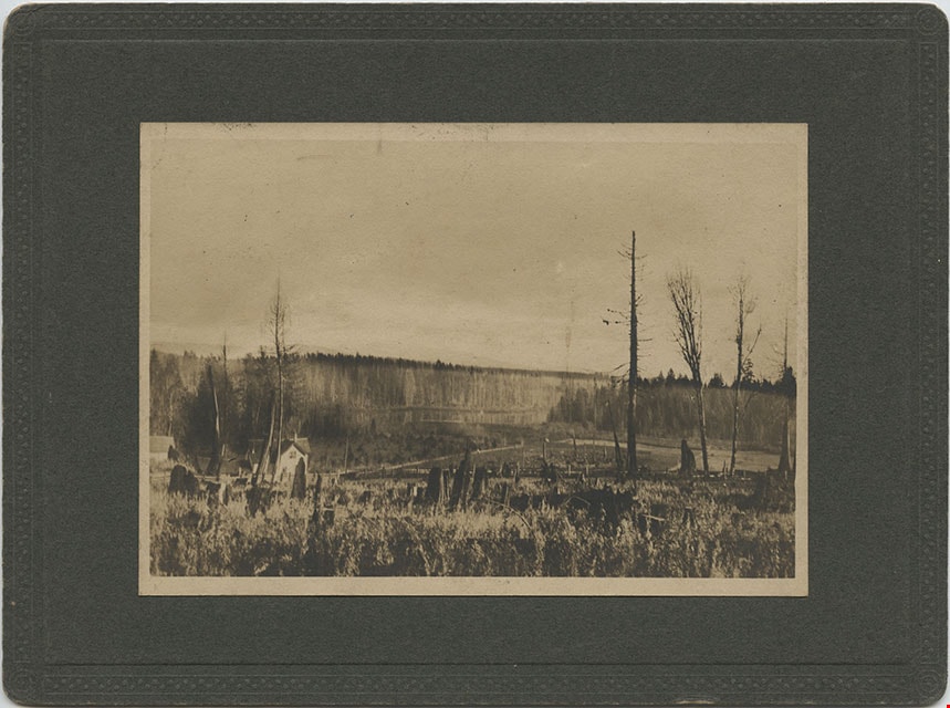
Looking from Woodlunds towards Burnaby Lake in 1899
https://search.heritageburnaby.ca/link/museumdescription992
- Repository
- Burnaby Village Museum
- Date
- 1899
- Collection/Fonds
- Burnaby Village Museum Photograph collection
- Description Level
- Item
- Physical Description
- 1 photograph : sepia photogravure ; 9.8 x 13.9 cm, mounted on cardboard 14.5 x 19.7 cm
- Scope and Content
- Photograph taken from "Woodlunds." Annotations in ink on the back of the card read, "Mr & Mrs G. Every-Clayton/ with Mr Haszard's/ wishes for a very/ Happy Xmas/ 1899" and "Looking from Woodlands / towards Burnaby Lake in 1899." Later annotation in blue ballpoint pen read, "Woodlunds the residence…
- Repository
- Burnaby Village Museum
- Collection/Fonds
- Burnaby Village Museum Photograph collection
- Description Level
- Item
- Physical Description
- 1 photograph : sepia photogravure ; 9.8 x 13.9 cm, mounted on cardboard 14.5 x 19.7 cm
- Scope and Content
- Photograph taken from "Woodlunds." Annotations in ink on the back of the card read, "Mr & Mrs G. Every-Clayton/ with Mr Haszard's/ wishes for a very/ Happy Xmas/ 1899" and "Looking from Woodlands / towards Burnaby Lake in 1899." Later annotation in blue ballpoint pen read, "Woodlunds the residence of Mr. Geo. Every-Clayton stood on the site of the present Centennial Pavilion, which when originally built was the residence of Mr. and Mrs. H.T. Ceperley. The proceeds from its sale was used to prepare the Ceperley playground in Stanley Park. The house in the left centre was that of Mr. and Mrs. Bernard R. Hill demolished to make way for entrance to Expressway."
- Names
- Every-Clayton, George
- Geographic Access
- Burnaby Lake
- Accession Code
- HV973.40.6
- Access Restriction
- No restrictions
- Reproduction Restriction
- No known restrictions
- Date
- 1899
- Media Type
- Photograph
- Scan Resolution
- 600
- Scan Date
- 2023-05-09
- Scale
- 100
- Notes
- Title based on contents of photograph
Images

Pioneer Days interviews September 22, 1971 - Track 2
https://search.heritageburnaby.ca/link/oralhistory267
- Repository
- City of Burnaby Archives
- Date Range
- 1899-1905
- Length
- 0:06:43
- Summary
- This portion of the recording includes Ada Evelyn (Lewis) Groves memories of her family life during the early days of Burnaby. She mentions the East Burnaby Fruit Farm (her family's farm) and the George Leaf General Store. She also talks about her brothers and her father, the first typesetter for t…
- Repository
- City of Burnaby Archives
- Summary
- This portion of the recording includes Ada Evelyn (Lewis) Groves memories of her family life during the early days of Burnaby. She mentions the East Burnaby Fruit Farm (her family's farm) and the George Leaf General Store. She also talks about her brothers and her father, the first typesetter for the Columbian newspaper. Ada is being interviewed in front of an audience at Heritage Village (now Burnaby Village Museum).
- Date Range
- 1899-1905
- Length
- 0:06:43
- Geographic Access
- 12th Avenue
- Historic Neighbourhood
- East Burnaby (Historic Neighbourhood)
- Planning Study Area
- Edmonds Area
- Interview Date
- September 22, 1971
- Scope and Content
- Recording is of interviews with Lillian May (Davies) Jones, Ada Evelyn (Lewis) Groves, Lillian Frederica (Lewis) Porter, and Elsie Wilson during the Pioneer Days celebration at Heritage Village (now Burnaby Village Museum) on September 22, 1971. Major themes discussed are: personal memories and occupations of interviewees family members.
- Biographical Notes
- Lillian May Davies was born June 28, 1891 to George and Rachel (Mills) Davies. She was one of four children. George Davies married Rachel Mills September 12, 1888 in Winnipeg and headed west to make their home. George’s brother Richard Davies had already bought property at the corner of 16th Street and 3rd Avenue (now 12th Avenue) when Rachel and George moved in and built a house next door. George Davies went to work for Gilley Bros. Logging Co. in Burnaby. Lillian May Davies married John Henry Jones on July 29, 1909 at the Methodist Church in Burnaby which had opened only a few weeks before (the Joneses were the first couple to be married there). Their reception was held in the Davies’ family garden. On June 3, 1910, Lillian and John’s first child, Arnold Jones was born. In 1919 they adopted their second child, John Sheldon Jones whose birth parents had died of influenza. John and Lillian built a home on the lot next to Lillian’s parents and lived there for forty-eight years. After her husband’s death in 1956, Lillian moved one lot over and remained living there for over twenty years. Lillian May (Davies) Jones died in Surrey on June 24, 1981 at the age of eighty-nine for over twenty years. Lillian May (Davies) Jones died in Surrey on June 24, 1981 at the age of eighty-nine. Ada Evelyn Lewis was born on September 11, 1899. She was one of nine Lewis children. Ada's father came to Victoria BC from San Francisco. He met his wife in Victoria and moved to New Westminster where he was a typesetter on the first edition of the Columbian newspaper. He continued to work for the Columbian until his retirement. Her family owned the East Burnaby Fruit Farm at 17th Avenue between 2nd and 4th Street where they harvested apples, plums and pears. Ada attended East Burnaby School in 1905 and remembers being a pupil of Miss Draper. Ada E. Lewis married and became Mrs. Ada Evelyn Groves. Lillian Frederica “Lillie” Lewis was born in 1896 to William Henry and Emma (Smith) Lewis at the family farm at 4th Street and 18th Avenue. The family grew to nine, eldest to youngest; Albert, Lizzie, Minnie, Walter, Ernest, Lillie and Evelyn. Lillie’s mother, Emma (Smith) had the distinction of being the first girl of European descent to be born at Fort Victoria. Lillie’s father, William Henry Lewis helped to print the very first edition of the Vancouver Province in 1898. Lillie attended Douglas Road School and remembers being a pupil of Ellen Lister. Lillian Frederica “Lillie” Lewis married Bertie Blaine Porter at Lulu Island on November 7, 1918. They lived in Vancouver for a short time before returning to Burnaby to raise their four children. For most of his working life Bert operated a steam roller for the municipality. Lillian Frederica (Lewis) Porter died May 18, 1988 at the age of ninety-two. Elsie Wilson was born August 16, 1898 to Annie and her second husband William Wilson. Annie’s first husband Samuel W Walmsley died December 20, 1895 at the age of thirty-five, leaving Annie a widow at twenty-seven with two young children Annie age four and Samuel age six. Annie Walmsley married her second husband William Wilson on April 17, 1897. Elsie attended West Burnaby public school (later Kingsway West elementary) and remembers picking raspberries at various Burnaby farms for seven seasons.
- Total Tracks
- 4
- Total Length
- 0:24:19
- Interviewee Name
- Jones, Lillian May Davies
- Wilson, Elsie
- Porter, Lillie Lewis
- Groves, Ada Evelyn Lewis
- Interview Location
- Burnaby Village Museum, Burnaby
- Collection/Fonds
- Burnaby Historical Society fonds
- Subseries
- Oral history subseries
- Transcript Available
- None
- Media Type
- Sound Recording
- Web Notes
- Interview was digitized in 2010 allowing it to be accessible on Heritage Burnaby. The digitization project was initiated by the Community Heritage Commission with support from City of Burnaby Council and the BC History Digitization Program of the Irving K. Barber Learning Centre, University of British Columbia. It was recognized by the Heritage Society of BC with an award in 2012.
Audio Tracks
Track two of recording of Pioneer Days interviews
Track two of recording of Pioneer Days interviews
https://search.heritageburnaby.ca/media/hpo/_Data/_Archives_Oral_Histories/_Unrestricted/MSS137-020/MSS137-020_Track_2.mp3Pioneer Days interviews September 22, 1971 - Track 4
https://search.heritageburnaby.ca/link/oralhistory269
- Repository
- City of Burnaby Archives
- Date Range
- 1899-1910
- Length
- 0:03:26
- Summary
- This portion of the recording includes Elise Wilson's memories of her family life during the early days of Burnaby, mentioning her mother Annie Walmsley Wilson. Elsie is being interviewed in front of an audience at Heritage Village (now Burnaby Village Museum). The audience briefly discusses Burnab…
- Repository
- City of Burnaby Archives
- Summary
- This portion of the recording includes Elise Wilson's memories of her family life during the early days of Burnaby, mentioning her mother Annie Walmsley Wilson. Elsie is being interviewed in front of an audience at Heritage Village (now Burnaby Village Museum). The audience briefly discusses Burnaby's early water supply.
- Date Range
- 1899-1910
- Length
- 0:03:26
- Names
- Wilson, Annie Walmsley
- Subjects
- Public Services - Utilities
- Interview Date
- September 22, 1971
- Scope and Content
- Recording is of interviews with Lillian May (Davies) Jones, Ada Evelyn (Lewis) Groves, Lillian Frederica (Lewis) Porter, and Elsie Wilson during the Pioneer Days celebration at Heritage Village (now Burnaby Village Museum) on September 22, 1971. Major themes discussed are: personal memories and occupations of interviewees family members.
- Biographical Notes
- Lillian May Davies was born June 28, 1891 to George and Rachel (Mills) Davies. She was one of four children. George Davies married Rachel Mills September 12, 1888 in Winnipeg and headed west to make their home. George’s brother Richard Davies had already bought property at the corner of 16th Street and 3rd Avenue (now 12th Avenue) when Rachel and George moved in and built a house next door. George Davies went to work for Gilley Bros. Logging Co. in Burnaby. Lillian May Davies married John Henry Jones on July 29, 1909 at the Methodist Church in Burnaby which had opened only a few weeks before (the Joneses were the first couple to be married there). Their reception was held in the Davies’ family garden. On June 3, 1910, Lillian and John’s first child, Arnold Jones was born. In 1919 they adopted their second child, John Sheldon Jones whose birth parents had died of influenza. John and Lillian built a home on the lot next to Lillian’s parents and lived there for forty-eight years. After her husband’s death in 1956, Lillian moved one lot over and remained living there for over twenty years. Lillian May (Davies) Jones died in Surrey on June 24, 1981 at the age of eighty-nine for over twenty years. Lillian May (Davies) Jones died in Surrey on June 24, 1981 at the age of eighty-nine. Ada Evelyn Lewis was born on September 11, 1899. She was one of nine Lewis children. Ada's father came to Victoria BC from San Francisco. He met his wife in Victoria and moved to New Westminster where he was a typesetter on the first edition of the Columbian newspaper. He continued to work for the Columbian until his retirement. Her family owned the East Burnaby Fruit Farm at 17th Avenue between 2nd and 4th Street where they harvested apples, plums and pears. Ada attended East Burnaby School in 1905 and remembers being a pupil of Miss Draper. Ada E. Lewis married and became Mrs. Ada Evelyn Groves. Lillian Frederica “Lillie” Lewis was born in 1896 to William Henry and Emma (Smith) Lewis at the family farm at 4th Street and 18th Avenue. The family grew to nine, eldest to youngest; Albert, Lizzie, Minnie, Walter, Ernest, Lillie and Evelyn. Lillie’s mother, Emma (Smith) had the distinction of being the first girl of European descent to be born at Fort Victoria. Lillie’s father, William Henry Lewis helped to print the very first edition of the Vancouver Province in 1898. Lillie attended Douglas Road School and remembers being a pupil of Ellen Lister. Lillian Frederica “Lillie” Lewis married Bertie Blaine Porter at Lulu Island on November 7, 1918. They lived in Vancouver for a short time before returning to Burnaby to raise their four children. For most of his working life Bert operated a steam roller for the municipality. Lillian Frederica (Lewis) Porter died May 18, 1988 at the age of ninety-two. Elsie Wilson was born August 16, 1898 to Annie and her second husband William Wilson. Annie’s first husband Samuel W Walmsley died December 20, 1895 at the age of thirty-five, leaving Annie a widow at twenty-seven with two young children Annie age four and Samuel age six. Annie Walmsley married her second husband William Wilson on April 17, 1897. Elsie attended West Burnaby public school (later Kingsway West elementary) and remembers picking raspberries at various Burnaby farms for seven seasons.
- Total Tracks
- 4
- Total Length
- 0:24:19
- Interviewee Name
- Jones, Lillian May Davies
- Wilson, Elsie
- Porter, Lillie Lewis
- Groves, Ada Evelyn Lewis
- Interview Location
- Burnaby Village Museum, Burnaby
- Collection/Fonds
- Burnaby Historical Society fonds
- Subseries
- Oral history subseries
- Transcript Available
- None
- Media Type
- Sound Recording
- Web Notes
- Interview was digitized in 2010 allowing it to be accessible on Heritage Burnaby. The digitization project was initiated by the Community Heritage Commission with support from City of Burnaby Council and the BC History Digitization Program of the Irving K. Barber Learning Centre, University of British Columbia. It was recognized by the Heritage Society of BC with an award in 2012.
Audio Tracks
Track four of recording of Pioneer Days interviews
Track four of recording of Pioneer Days interviews
https://search.heritageburnaby.ca/media/hpo/_Data/_Archives_Oral_Histories/_Unrestricted/MSS137-020/MSS137-020_Track_4.mp3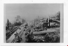
Aftermath of Great Fire of New Westminster, 1898
https://search.heritageburnaby.ca/link/museumdescription4781
- Repository
- Burnaby Village Museum
- Date
- 1898
- Collection/Fonds
- Burnaby Village Museum Photograph collection
- Description Level
- Item
- Physical Description
- 1 photograph : b&w ; 8.8 x 12.7 cm ; copy print
- Scope and Content
- Brick ruins of buildings on either side of a street with people, wagons and horses. Street runs top to bottom on left hand side of photograph.
- Repository
- Burnaby Village Museum
- Collection/Fonds
- Burnaby Village Museum Photograph collection
- Description Level
- Item
- Physical Description
- 1 photograph : b&w ; 8.8 x 12.7 cm ; copy print
- Material Details
- "Columbian files 1971" written on verso in black pen. ""FIRE" NEW WESTMINSTER SEPT. 1898." written on verso in pencil.
- Scope and Content
- Brick ruins of buildings on either side of a street with people, wagons and horses. Street runs top to bottom on left hand side of photograph.
- History
- Part of a set of photographs from the Columbian Newspaper, which operated out of New Westminster under this name starting in 1900 until its dissolution in 1988. Photographs found in the collection of the Burnaby Village are dated 1971.
- Other Title Information
- title based on content and note on verso of photograph
- Accession Code
- BV018.19.7
- Access Restriction
- No restrictions
- Reproduction Restriction
- May be restricted by third party rights
- Date
- 1898
- Media Type
- Photograph
- Scan Resolution
- 600
- Scan Date
- 24-04-2018
Images

![Survey and Subdivision plans in New Westminster District Group 1 & Group 2 - Port Moody, Surrey
, [1898-1910] thumbnail](/media/hpo/_Data/_BVM_Cartographic_Material/1977/1977_0093_0073_001.jpg?width=280)
Survey and Subdivision plans in New Westminster District Group 1 & Group 2 - Port Moody, Surrey
https://search.heritageburnaby.ca/link/museumdescription7042
- Repository
- Burnaby Village Museum
- Date
- [1898-1910]
- Collection/Fonds
- Burnaby Village Museum Map collection
- Description Level
- File
- Physical Description
- 10 plans : graphite and ink on paper and linen; various sizes mounted on 2 sides of cardboard 76 x 102 cm
- Scope and Content
- File consists of a large board with four plans in New Westminster District mounted on one side and six plans mounted on the other side. Side A: 1. Plan : black ink and graphite on paper ; 46.5 x 37.5 cm. Title reads: "Bon Accord Hatchery / Sec 6 B5N R1W". Signed by Albert J. Hill P.L.S. August 1…
- Repository
- Burnaby Village Museum
- Collection/Fonds
- Burnaby Village Museum Map collection
- Description Level
- File
- Physical Description
- 10 plans : graphite and ink on paper and linen; various sizes mounted on 2 sides of cardboard 76 x 102 cm
- Material Details
- Scales vary (One chain equals 792 inches)
- Indexed number on tape on edge of board reads "73"
- Scope and Content
- File consists of a large board with four plans in New Westminster District mounted on one side and six plans mounted on the other side. Side A: 1. Plan : black ink and graphite on paper ; 46.5 x 37.5 cm. Title reads: "Bon Accord Hatchery / Sec 6 B5N R1W". Signed by Albert J. Hill P.L.S. August 12, 1903. Plan covers land identified as Section 6, Section 7, Located along the south shore of the Fraser River in Port Mann (Geographic location: Surrey). 2. Plan : black ink and graphite on paper ; 36 x 31 cm. Title reads: "Survey of Portions of Sec. 20 B5N R2W". Plan is stamped in red ink: "Albert J. Hill, Civil Engineer". Scale 4 chains = 1 inch. 3. Plan : black ink on linen ; 14 x 23 cm. Title reads:"Port Moody". Plan covers sections in Lot 191 (District Lot 191) bordered by Burrard Inlet to the west and Lot 235 and Lot 233 to the south. Streets identified include Water Street, Beauregard Street, Yonge Street, Clinton Street and Oxford Street. 4. Plan: graphite and ink on paper ; 43.5 x 64.5 cm. Title reads: "Sketch Plan Approved by Council [sic] / _[sic]1898". (No identifying geographic landmarks provided) Side B: 1. Plan : graphite on paper ; 53.5 x 31 cm. Title reads: "Plan of Lot 13, Gr. II, N.W. Dist". Sketch plan covers area along the Fraser River in District Lot 13, New Westminster District, Group 2. District Lot 13 is bordered by District Lot 14 (to the west) and Lot 12 (to the east). Natural geographic features within District Lot 13 are noted as "dense brush and fallen timber / sallal / rough spruce and cedar / swamp / fine alder / sallal / fine alder bottom land / fine brook". Scale: 3 chains = 1 inch (Geographic location: Surrey) 2. Plan : black ink on paper ; 50.5 x 34.5 cm. Title reads: "Indian Reserve / Opposite / New Westminster". Plan covers area on the south shore of the Fraser River in New Westminster District Group 2 in an area known as Brownsville. Lots are identified as District Lots 1, 2, 3, 4, 18, 17 and 8 and Sections A and B. Two areas of land are noted as "Indian Reserve"; one 6.3 acre parcel and one 104.25 acre parcel, both within District Lot 1. Note on plan reads: "N.B. this plan shows reserves and adjacent properties as they are on the ground". (Geographic location: Surrey) 3. Plan : black and col. ink on paper ; 19.5 x 31.5 cm. Title reads: "Bon Accord Road". Plan shows elevation. "Average section 10 feet = 1 inch". Plan is stamped in red ink: "Albert J. Hill, Civil Engineer and Provincial Land Surveyor, New Westminster, B.C." (Geographic location: Surrey) 4. Plan : black and col. ink on linen ; 16.5 x 25.5 cm. (no formal title) Plan covers area of Section 35, south of Yale Wagon Road and east of Quible Road. Plan is signed by "Albert J. Hill / B.C.L.S." (Geographic location: Surrey) 5. Plan: black and col. ink on linen ; 22.5 x 22.5 cm. (no formal title) Plan covers area between Yale Road and Townline Road in Surrey. Scale: 4 chains = 1 inch. Plan is signed by Albert J. Hill B.C.L.S. [190-] (Geographic location: Surrey) 6. Plan : graphite on paper ; 24 x 54 cm. (no formal title) Plan covers sectioned areas along Bon Accord Road. Sections are identified as " Sec. 8 / T.F. Patterson"; "Sec. 9 / Russell"; "Elliott_Burnett_Crean / Sec. 16"; "Dom. Govt. / Sec. 17". (Geographic location: Surrey, beneath the Port Mann bridge)
- Names
- ʷməθkʷəy̓əm (Musqueam)
- Accession Code
- HV977.93.73
- Access Restriction
- No restrictions
- Reproduction Restriction
- No known restrictions
- Date
- [1898-1910]
- Media Type
- Cartographic Material
- Scan Resolution
- 600
- Scan Date
- 2023-06-26
- Notes
- Title based on contents of file
- Note re plan 2B: The sight of Brownsville was also the former site of the Qayqayt First Nation and one of the main summer villages of the Kwantlen and ʷməθkʷəy̓əm (Musqueam) peoples
Zoomable Images
![Survey and Subdivision plans in New Westminster District Group 1 & Group 2 - Port Moody, Surrey
, [1898-1910] thumbnail](/media/hpo/_Data/_BVM_Cartographic_Material/1977/1977_0093_0073_003_seadragon/1977_0093_0073_003.jpg?w=280)
Survey and Subdivision plans in New Westminster District Group 1 & Group 2 - Port Moody, Surrey , [1898-1910]
Zoom into Image
![Survey and Subdivision plans in New Westminster District Group 2 - Surrey, Delta
, [1898-1910] thumbnail](/media/hpo/_Data/_BVM_Cartographic_Material/1977/1977_0093_0078_001.jpg?width=280)
Survey and Subdivision plans in New Westminster District Group 2 - Surrey, Delta
https://search.heritageburnaby.ca/link/museumdescription7047
- Repository
- Burnaby Village Museum
- Date
- [1898-1910]
- Collection/Fonds
- Burnaby Village Museum Map collection
- Description Level
- File
- Physical Description
- 10 plans : graphite and ink on paper and linen; various sizes mounted on 2 sides of cardboard 76 x 102 cm
- Scope and Content
- File consists of a large board with four plans in New Westminster District mounted on one side and six plans mounted on the other side. Side A: 1. Plan : black ink on paper with colour (no formal title). Plan covers area in New Westminster District, Group 2 situated along the south shore of the …
- Repository
- Burnaby Village Museum
- Collection/Fonds
- Burnaby Village Museum Map collection
- Description Level
- File
- Physical Description
- 10 plans : graphite and ink on paper and linen; various sizes mounted on 2 sides of cardboard 76 x 102 cm
- Material Details
- Scales vary
- Indexed number on tape on edge of board reads "78"
- Scope and Content
- File consists of a large board with four plans in New Westminster District mounted on one side and six plans mounted on the other side. Side A: 1. Plan : black ink on paper with colour (no formal title). Plan covers area in New Westminster District, Group 2 situated along the south shore of the Fraser River identified as "Indian Reserve / Turner 1868" situated in District Lot 1 between District Lot 2 identified as "Mohun's Line" and "Herring's Line" bordered by lots B and A. Includes note "see plan of subdivision of Lots 3 & 4 Gr. 2". (Geographic location: Surrey) 2. Plan : graphite on paper ; Title reads: "B5N R2W, Sec.26_Sec. 28 / Sec. 35_Sec.36". Plan covers a 60 acre parcel in Sec. 35 with Yale wagon road to the south. Scale: 6 chains = 1 inch (Geographic location: Surrey) 3. Plan : black ink on paper ; Title reads: "Survey for Proposed Highway in Indian Reserve Surrey". Plan covers area of land to the northwest of Lot 2 along the shore of the Fraser River and identfies route of proposed highway, proposed tramway as well at the Great Northern Railway and bridge. Scale: 2 chains = 1 inch 4. Plan : black ink on red lined graphing paper ; Title reads: "Sketch Plan Showing Section of Great Northern R. of W. at Point of Crossing of Proposed Ditch". Plan covers area of Lot 2 in New Westminster District, Group 2. (Surrey) Scale: 1 inch = 5 feet. (Geographic location: Surrey) Side B: 1. Plan : black ink on paper ; Title reads: "Plan of Subdivision of a Portion of Section 13, TP2, Surrey Municipality, New Westminster District, B.C.". Plan covers land bordered by Coast Meridian Road (to the east), Bose Road (to the south) and Pike Road (to the west). Surveyed for D.S. Bayners, Nov. 24, 1908. Scale: 5 chains= 1 inch 2. Plan : black ink on linen with colour ; Title reads: "Traverse of the Waterline in front of Lots 3 and 4, Group 2, New Westminster District with G.N. Railway Right of Way". Plan covers area along the southern shore of the Fraser River with a road crossing the Great Northern Railway and leading to a wharf. Scale: 100 feet = 1 inch (Geographic location: Surrey) 3. Plan : black ink on paper ; Title reads: "Survey of the South Boundary of Sec. 12, Township 2, New Westminster District". Plan covers area south of Bose Road and west of Coast Meridean Road and north of McClellen Road. Scale: 400 feet = 1 inch. Sec.12 (Geographic location: Surrey) 4. Plan : graphite on paper ; Title reads: "Plan of Subdivisioin of a part of S.E. 1/4 of Sec. 7, TP 8". Plan covers area of Section 7 in New Westminster District, Group 2, Township 8. Streets are identified running through lot including, Langley Ave., Robinson Ave, Melrose Ave., Hawthorne Ave., Broadway, Bond Ave., Mable Ave., Breene Ave. and McLelland Ave. and Clover Valley Road. Scale: 200 feet = 1 inch. Note in black ink reads: See Bd. 166 for blue print. (Geographic location: Surrey) 5. Plan : graphite on linen ; Title reads: "Sec.20, B5N R2W". Plan covers area north of Yale Road and is subdivided into parts identified as A, B, C, D, E, and unknown. (Geographic location: Surrey) 6. Plan : black ink and graphite on paper ; (no formal title) Plan covers lots surveyed along Ladner Road identified as A, B and Lots 13, 12 and 11. [Geographic location: Delta]
- Accession Code
- HV977.93.78
- Access Restriction
- No restrictions
- Reproduction Restriction
- No known restrictions
- Date
- [1898-1910]
- Media Type
- Cartographic Material
- Scan Resolution
- 600
- Scan Date
- 2023-06-26
- Notes
- Title based on contents of file
- Note re plans 1A & 3A: The sight of Brownsville was also the former site of the Qayqayt First Nation and one of the main summer villages of the Kwantlen and ʷməθkʷəy̓əm (Musqueam) peoples
- Scale is measured in chains and feet. (One chain equals 792 inches)
Zoomable Images
![Survey and Subdivision plans in New Westminster District Group 2 - Surrey, Delta
, [1898-1910] thumbnail](/media/hpo/_Data/_BVM_Cartographic_Material/1977/1977_0093_0078_003_seadragon/1977_0093_0078_003.jpg?w=280)
Survey and Subdivision plans in New Westminster District Group 2 - Surrey, Delta , [1898-1910]
Zoom into Image
Millway family fonds
https://search.heritageburnaby.ca/link/archivedescription97224
- Repository
- City of Burnaby Archives
- Date
- 1898-1986
- Collection/Fonds
- Millway family fonds
- Description Level
- Fonds
- Physical Description
- 4.5 cm. of textual records + 8 photographs (1 b&w , 18.5 x 23.5 cm ; 2 col. , 15 x 10 cm ; 5 col. , 10 x 30.5 cm) + 1 audio disc (66 min., 47 sec).
- Scope and Content
- Fonds consists of material collected and complied by Reginald and Betty Millway.
- Repository
- City of Burnaby Archives
- Date
- 1898-1986
- Collection/Fonds
- Millway family fonds
- Physical Description
- 4.5 cm. of textual records + 8 photographs (1 b&w , 18.5 x 23.5 cm ; 2 col. , 15 x 10 cm ; 5 col. , 10 x 30.5 cm) + 1 audio disc (66 min., 47 sec).
- Description Level
- Fonds
- Accession Number
- 2011-05
- Scope and Content
- Fonds consists of material collected and complied by Reginald and Betty Millway.
- History
- Reginald E. "Reg" Millway was born on December 20, 1915, at Milton Regis in the County of Kent. He graduated from London University (via Regent Street Polytechnic) and was appointed to the Air Ministry Technical Division in 1937, where he remained throughout World War II. Due to a hearing impairment he was unable to join the services and instead joined the Home Guard and served on fire bomb patrol in central London. Betty was born November 16, 1916, and married Reginald Millway in 1940. Together they had four daughters: Catherine; Penelope “Penny”; Jennifer; and Francis “Fran” (later Malcolm). Reginald left Britain with his family in March of 1948. They were on the last voyage of the Acquitania to Halifax, took a parlour car in a C.N. train to New Westminster and took up residence in South Burnaby. After two or three years, Reginald had established his own business, Marine Electronics. When the United Flower Growers Cooperative formed in the late 1950s, Reginald helped them assemble property at Roseberry and Marine Way in cooperation with the Director of Planning. A large auditorium was built there and Reginald helped them design, manufacture and install a complete electronic system. Modifications and additions have occurred along the way to the point that it is handling millions of dollars worth of flowers annually and it is the largest operation of its kind in Canada. Reginald ran in the Burnaby elections of 1957. Newly elected Mayor Alan Emmot offered him the chairmanship of the Zoning Board of Appeal (later the Board of Variance). He remained continuously chairman for the next 35 years. In 1962, Reginald joined the Rotary Club of Burnaby. He served as president in 1969 and remained a member for over 45 years. Betty was an accomplished writer and was the recipient of the 1984 Canadian Author’s Association Allan Sagster Award for long and meritorious service. Reginald was an early member of the Burnaby Historical Society and served as its president for three terms. He and Blythe Eagles went to Loughborough, England, on behalf of the Society to locate and clean up the site of Robert Burnaby's grave. Reginald was also on the committee that acquired the property and organised the establishment of the Burnaby Village Museum. Betty developed Robert Burnaby's family tree for the Historical Society and in the process made many contacts with prominent citizens of the Loughborough area, including the executive controller of the area, who introduced the Millways to the Mayor and Council. This formed the groundwork for a close relationship which Mayor Bill Lewarne formerly developed as a SisterCity relationship in 1985. The Millways were longstanding members of the Burnaby Beautification Committee and their garden was featured in Gardens West in the 1998 November/December issue. Betty died on July 21, 2005. Reginald died on November 7, 2010.
- Media Type
- Photograph
- Textual Record
- Sound Recording
- Notes
- Title based on contents of fonds
- MSS157, PC 353
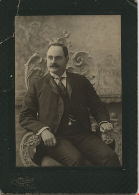
David M. McLean
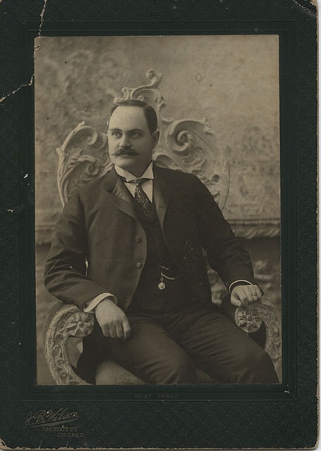
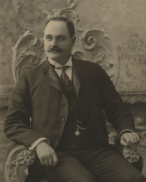
https://search.heritageburnaby.ca/link/museumdescription392
- Repository
- Burnaby Village Museum
- Date
- December 1898
- Collection/Fonds
- Burnaby Village Museum Photograph collection
- Description Level
- Item
- Physical Description
- 1 photograph : b&w ; 13.34 x 18.42 cm
- Scope and Content
- Photograph of David M. McLean from Chicago, taken in a photographic studio. He is seated on a chair with floral motif backing. He has a moustache, and is wearing a suit with a vest with a pocket watch hanging from his vest pocket. His tie is patterned with strings and dots, and he is wearing cuffli…
- Repository
- Burnaby Village Museum
- Collection/Fonds
- Burnaby Village Museum Photograph collection
- Description Level
- Item
- Physical Description
- 1 photograph : b&w ; 13.34 x 18.42 cm
- Material Details
- printed on the card mount, recto, l.l. "J. B. Wilson/ 389 STATE ST./ CHICAGO", b. "BEST GRADE." inscribed in blue ink, verso, t. " "A Merry Xmas" 1898/ David M McLean/ Chicago"
- The photograph is mounted on a card supplied by the photo studio. The card mount is bent at u.l. corner
- Scope and Content
- Photograph of David M. McLean from Chicago, taken in a photographic studio. He is seated on a chair with floral motif backing. He has a moustache, and is wearing a suit with a vest with a pocket watch hanging from his vest pocket. His tie is patterned with strings and dots, and he is wearing cufflinks. His relationship to the donor and to Burnaby is not known.
- Names
- McLean, David M
- Accession Code
- HV983.42.132
- Reproduction Restriction
- No known restrictions
- Date
- December 1898
- Media Type
- Photograph
- Scan Resolution
- 600
- Scan Date
- 2023-11-21
- Photographer
- Wilson, J.B.
- Notes
- Title based on contents of photograph
Images
Millway family subseries
https://search.heritageburnaby.ca/link/archivedescription66632
- Repository
- City of Burnaby Archives
- Date
- 1898-1986
- Collection/Fonds
- Burnaby Historical Society fonds
- Description Level
- Subseries
- Physical Description
- Textual records and 1 photograph
- Scope and Content
- Subseries consists of material created and collected by Reginald and Betty Millway, including a map of the Municipal of Burnaby and research on Robert Burnaby.
- Repository
- City of Burnaby Archives
- Date
- 1898-1986
- Collection/Fonds
- Burnaby Historical Society fonds
- Subseries
- Millway family subseries
- Physical Description
- Textual records and 1 photograph
- Description Level
- Subseries
- Accession Number
- BHS1997-12
- BHS1999-11
- Scope and Content
- Subseries consists of material created and collected by Reginald and Betty Millway, including a map of the Municipal of Burnaby and research on Robert Burnaby.
- History
- Reginald E. "Reg" Millway was born on December 20, 1915 at Milton Regis in the County of Kent. He graduated from London University via Regent Street Polytechnic and was appointed to the Air Ministry Technical Division in 1937, where he remained throughout World War II. Due to a hearing impairment he was unable to join the services and instead joined the Home Guard and served on fire bomb patrol in central London. Betty was born November 16, 1916. She married Reginald in 1940. Together they had four daughters: Catherine, Penelope “Penny”, Jennifer and Francis “Fran”. The Millways left Britain in March 1948. They sailed on the last voyage of the Acquitania to Halifax, and then took a parlour car in a C.N. train to New Westminster and took up residence in South Burnaby. After two or three years, Reginald had established his own business, Marine Electronics. When the United Flower Growers Cooperative formed in the late 1950s, Reginald helped them assemble property at Roseberry and Marine Way in cooperation with the Director of Planning. A large auditorium was built there and Reginald helped them design, manufacture and install a complete electronic system. Modifications and additions have occurred along the way to the point that it is handling millions of dollars worth of flowers annually and it is the largest operation of its kind in Canada. Reginald Millway ran in the Burnaby elections of 1957. Newly elected Mayor Alan Emmot offered him the chairmanship of the Zoning Board of Appeal (later the Board of Variance). He remained chairman for the next 35 years. In 1962, he joined the Rotary Club of Burnaby; he served as president of the club in 1969 and was a member for over 45 years. Reginald was also an early member of the Burnaby Historical Society. He served as its president for three terms. He and Blythe Eagles went to Loughborough, England, on behalf of the Society to locate and clean up the site of Robert Burnaby's grave. Reginald was also on the committee that acquired the property and organised the establishment of the Burnaby Village Museum. Betty Millway was an accomplished writer and received the 1984 Canadian Author’s Association Allan Sagster Award for long and meritorious service. She developed Robert Burnaby's family tree for the Historical Society and in the process made many contacts with prominent citizens of Loughborough, including the executive controller of the area, who introduced the Millways to the Mayor and Council. This formed the groundwork for a close relationship which Mayor Bill Lewarne formerly developed as a Sister City relationship in 1985. The Millways were longstanding members of the Burnaby Beautification Committee and their garden was featured in Gardens West in the 1998 November/December issue. Betty Millway died July 21, 2005. Reginald E. Millway died November 7, 2010.
- Media Type
- Photograph
- Textual Record
- Notes
- Title based on contents of subseries
- PC353, MSS157

Map of South Western Part of British Columbia
https://search.heritageburnaby.ca/link/museumdescription8688
- Repository
- Burnaby Village Museum
- Date
- 1897
- Collection/Fonds
- Burnaby Village Museum Map collection
- Description Level
- Item
- Physical Description
- 1 map : col. ink on paper ; 68 x 88 cm
- Scope and Content
- Item consists of a "MAP OF THE SOUTH-WESTERN PART OF BRITISH COLUMBIA”. Map identifies geographic land districts of New Westminster District; Coast District; Lillooet District; Yale District, Kamloops Division, Yale Division and districts on Vancouver Island. Map also includes the northern portions…
- Repository
- Burnaby Village Museum
- Collection/Fonds
- Burnaby Village Museum Map collection
- Description Level
- Item
- Physical Description
- 1 map : col. ink on paper ; 68 x 88 cm
- Material Details
- Scale [1:633600]
- Scope and Content
- Item consists of a "MAP OF THE SOUTH-WESTERN PART OF BRITISH COLUMBIA”. Map identifies geographic land districts of New Westminster District; Coast District; Lillooet District; Yale District, Kamloops Division, Yale Division and districts on Vancouver Island. Map also includes the northern portions of the State of Washington below the 49th parallel.
- Publisher
- The Colonist Litho Victoria B.C.
- Responsibility
- Martin, George Bohun
- Accession Code
- BV993.12.12
- Access Restriction
- No restrictions
- Reproduction Restriction
- No known restrictions
- Date
- 1897
- Media Type
- Cartographic Material
- Scan Resolution
- 600
- Scan Date
- 2023-08-17
- Notes
- Transcribed title
- Scale equals 1 inch to 10 miles
- "Compiled and drawn by direction of the Honouable G.B. Martin, Chief Commissioner of Lands and Works, Victoria, B.C."
- Signed by Surveyor General "Tom Kains"
Zoomable Images

![Douglas Road, [1897] (date of original), copied 1978 thumbnail](/media/hpo/_Data/_BVM_Images/1978/1978_0001_0001_001.jpg?width=280)
Douglas Road
https://search.heritageburnaby.ca/link/museumdescription447
- Repository
- Burnaby Village Museum
- Date
- [1897] (date of original), copied 1978
- Collection/Fonds
- Burnaby Village Museum Photograph collection
- Description Level
- Item
- Physical Description
- 1 photograph : b&w ; 20.2 x 25.2 cm print
- Scope and Content
- Photograph of Douglas Road (later renamed in part Canada Way), near Stanley Street. To the right is the Sprott family property, where a few wooden buildings are visible in the cleared area. Charles Sprott, head of the Sprott family, was an important Burnaby politician who was continuously elected t…
- Repository
- Burnaby Village Museum
- Collection/Fonds
- Burnaby Village Museum Photograph collection
- Description Level
- Item
- Physical Description
- 1 photograph : b&w ; 20.2 x 25.2 cm print
- Scope and Content
- Photograph of Douglas Road (later renamed in part Canada Way), near Stanley Street. To the right is the Sprott family property, where a few wooden buildings are visible in the cleared area. Charles Sprott, head of the Sprott family, was an important Burnaby politician who was continuously elected to serve in the municiality as councillor from 1895 to 1903 and as Reeve from 1904 to 1905.
- Subjects
- Geographic Features - Roads
- Land Clearing
- Geographic Access
- Douglas Road
- Canada Way
- Stanley Street
- Accession Code
- HV978.1.1
- Access Restriction
- No restrictions
- Reproduction Restriction
- No known restrictions
- Date
- [1897] (date of original), copied 1978
- Media Type
- Photograph
- Historic Neighbourhood
- Burnaby Lake (Historic Neighbourhood)
- Planning Study Area
- Lakeview-Mayfield Area
- Scan Resolution
- 600
- Scan Date
- 2023-07-25
- Notes
- Title based on contents of photograph
Images
![Douglas Road, [1897] (date of original), copied 1978 thumbnail](/media/hpo/_Data/_BVM_Images/1978/1978_0001_0001_001.jpg)
![B.C. Sugar Refinery Picnic, [1897] thumbnail](/media/hpo/_Data/_BVM_Images/1976/1976_0036_0029_001.jpg?width=280)
B.C. Sugar Refinery Picnic
https://search.heritageburnaby.ca/link/museumdescription667
- Repository
- Burnaby Village Museum
- Date
- [1897]
- Collection/Fonds
- Burnaby Village Museum Photograph collection
- Description Level
- Item
- Physical Description
- 1 photograph : b&w ; 17 x 38 cm
- Scope and Content
- Photograph of a large group picnic. Banners tied between two trees behind the group read "B.C.S.[last letter obscured by an individual] 6th ANNUAL PICNIC" and "ROGERS' GOLDEN SYRUP." It is speculated that this photograph is of the British Columbia Sugar Refining Company's (sixth annual) picnic.
- Repository
- Burnaby Village Museum
- Collection/Fonds
- Burnaby Village Museum Photograph collection
- Description Level
- Item
- Physical Description
- 1 photograph : b&w ; 17 x 38 cm
- Scope and Content
- Photograph of a large group picnic. Banners tied between two trees behind the group read "B.C.S.[last letter obscured by an individual] 6th ANNUAL PICNIC" and "ROGERS' GOLDEN SYRUP." It is speculated that this photograph is of the British Columbia Sugar Refining Company's (sixth annual) picnic.
- Subjects
- Recreational Activities - Picnics
- Accession Code
- HV976.36.29
- Access Restriction
- No restrictions
- Reproduction Restriction
- No known restrictions
- Date
- [1897]
- Media Type
- Photograph
- Scan Resolution
- 300
- Scan Date
- 17/8/2006
- Scale
- 100
- Photographer
- Dominion Photo Studio
- Notes
- Title based on contents of photograph
Images
![B.C. Sugar Refinery Picnic, [1897] thumbnail](/media/hpo/_Data/_BVM_Images/1976/1976_0036_0029_001.jpg)
![Claude Hill in front of log pile, [1897] thumbnail](/media/hpo/_Data/_BVM_Images/1973/1973_0040_0002_001.jpg?width=280)
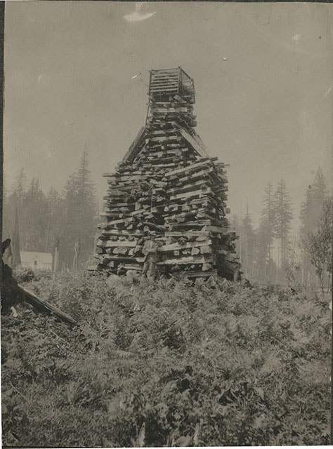
Claude Hill in front of log pile
https://search.heritageburnaby.ca/link/museumdescription989
- Repository
- Burnaby Village Museum
- Date
- [1897]
- Collection/Fonds
- Burnaby Village Museum Photograph collection
- Description Level
- Item
- Physical Description
- 1 photograph : sepia ; 9.6 x 7.1 cm mounted on cardboard 14.9 x 12.5 cm
- Scope and Content
- Photograph of a large stack of wood prepared for a bonfire on a hill. The bonfire stack is towering over a man who stands in front of it with his arms crossed and wearing a hat. There is a house seen in the background to the left of the photograph. The photograph is identified by the acquisition…
- Repository
- Burnaby Village Museum
- Collection/Fonds
- Burnaby Village Museum Photograph collection
- Description Level
- Item
- Physical Description
- 1 photograph : sepia ; 9.6 x 7.1 cm mounted on cardboard 14.9 x 12.5 cm
- Scope and Content
- Photograph of a large stack of wood prepared for a bonfire on a hill. The bonfire stack is towering over a man who stands in front of it with his arms crossed and wearing a hat. There is a house seen in the background to the left of the photograph. The photograph is identified by the acquisition record and inscription on the back as Queen Victoria's Jubilee bonfire. There is a discrepancy in the records as to who the man is. Some have identified him as Bernard Hill, others, as Mr. L.C. Hill. An annotation on th back of the photo reads, "1897/ Queen Victorias Jubilee/ Bonfire prepared by Mr LC Hill/ just above what is now Deer/ Lake Ave and below the/ present Centennial Pavilion."
- Subjects
- Celebrations - Jubilee
- Geographic Access
- Deer Lake
- Accession Code
- HV973.40.2
- Access Restriction
- No restrictions
- Reproduction Restriction
- No known restrictions
- Date
- [1897]
- Media Type
- Photograph
- Historic Neighbourhood
- Burnaby Lake (Historic Neighbourhood)
- Related Material
- For another photograph of the bonfire prepared by L. C. Hill, see photograph HV976.139.49
- Scan Resolution
- 600
- Scan Date
- 2023-05-09
- Scale
- 100
- Notes
- Title based on contents of photograph
Images
![Claude Hill in front of log pile, [1897] thumbnail](/media/hpo/_Data/_BVM_Images/1973/1973_0040_0002_001.jpg)
![Brookfield, [1896] thumbnail](/media/hpo/_Data/_BVM_Images/1973/1973_0040_0001_001.jpg?width=280)
Brookfield
https://search.heritageburnaby.ca/link/museumdescription988
- Repository
- Burnaby Village Museum
- Date
- [1896]
- Collection/Fonds
- Burnaby Village Museum Photograph collection
- Description Level
- Item
- Physical Description
- 1 photograph : b&w ; 12.1 x 17.7 cm
- Scope and Content
- Photograph of the house built about 1894 that Louis Claud Hill called "Brookfield." Mr. Hill was married that year to Annie Sara Kendrick, and they took up residence in the house until 1906 when they sold the property and built a new home in the vicinity of Buckingham and Sperling. Brookfield was…
- Repository
- Burnaby Village Museum
- Collection/Fonds
- Burnaby Village Museum Photograph collection
- Description Level
- Item
- Physical Description
- 1 photograph : b&w ; 12.1 x 17.7 cm
- Scope and Content
- Photograph of the house built about 1894 that Louis Claud Hill called "Brookfield." Mr. Hill was married that year to Annie Sara Kendrick, and they took up residence in the house until 1906 when they sold the property and built a new home in the vicinity of Buckingham and Sperling. Brookfield was still on the property when the Burnaby Village Museum was planned in 1971 as Heritage Village, but it was torn down to make room for other buildings on the site. An acquisition record notes that this house stood immediately behind the Elworth House, and Colonel Peers' (the donor) mother was born in this house in 1898. Annotations on the back of the photo read, "1896 'Brookfield'" and "The residence of Mr.+Mrs. LC Hill, the first residence on the site of Heritage Court. It stood immediately behind what is now called the Manor House. Built about 1894."
- Subjects
- Buildings - Residential - Houses
- Geographic Access
- Deer Lake Avenue
- Street Address
- 6501 Deer Lake Avenue
- Accession Code
- HV973.40.1
- Access Restriction
- No restrictions
- Reproduction Restriction
- No known restrictions
- Date
- [1896]
- Media Type
- Photograph
- Historic Neighbourhood
- Burnaby Lake (Historic Neighbourhood)
- Planning Study Area
- Morley-Buckingham Area
- Scan Resolution
- 600
- Scan Date
- 2023-05-09
- Scale
- 100
- Notes
- Title based on contents of photograph
Images
![Brookfield, [1896] thumbnail](/media/hpo/_Data/_BVM_Images/1973/1973_0040_0001_001.jpg)

Brookfield
https://search.heritageburnaby.ca/link/archivedescription39520
- Repository
- City of Burnaby Archives
- Date
- 1896
- Collection/Fonds
- Peers Family and Hill Family fonds
- Description Level
- Item
- Physical Description
- 1 photograph : b&w ; 11.5 x 16.1 cm on page 21.5 x 28 cm (pasted in album)
- Scope and Content
- Photograph of the home of Claude Hill in the Burnaby Lake district. It was known as Brookfield. The property is the current site of the Burnaby Village Museum.
- Repository
- City of Burnaby Archives
- Date
- 1896
- Collection/Fonds
- Peers Family and Hill Family fonds
- Physical Description
- 1 photograph : b&w ; 11.5 x 16.1 cm on page 21.5 x 28 cm (pasted in album)
- Description Level
- Item
- Record No.
- 477-839
- Access Restriction
- No restrictions
- Reproduction Restriction
- No known restrictions
- Accession Number
- 2007-12
- Scope and Content
- Photograph of the home of Claude Hill in the Burnaby Lake district. It was known as Brookfield. The property is the current site of the Burnaby Village Museum.
- Subjects
- Buildings - Residential - Houses
- Media Type
- Photograph
- Notes
- Title based on contents of photograph
- Geographic Access
- Deer Lake Avenue
- Street Address
- 6501 Deer Lake Avenue
- Historic Neighbourhood
- Burnaby Lake (Historic Neighbourhood)
- Planning Study Area
- Morley-Buckingham Area
Images

![Brookfield, [1896] thumbnail](/media/hpo/_Data/_Archives_Images/_Unrestricted/477/477-945.jpg?width=280)
Brookfield
https://search.heritageburnaby.ca/link/archivedescription66232
- Repository
- City of Burnaby Archives
- Date
- [1896]
- Collection/Fonds
- Peers Family and Hill Family fonds
- Description Level
- Item
- Physical Description
- 1 photograph : b&w ; 9.5 x 13 cm
- Scope and Content
- Photograph of the first home of Claude Hill in the Burnaby Lake district. It was known as Brookfield. This was the birthplace of Kitty Hill. The property is the current site of the Burnaby Village Museum.
- Repository
- City of Burnaby Archives
- Date
- [1896]
- Collection/Fonds
- Peers Family and Hill Family fonds
- Physical Description
- 1 photograph : b&w ; 9.5 x 13 cm
- Description Level
- Item
- Record No.
- 477-945
- Access Restriction
- No restrictions
- Reproduction Restriction
- No known restrictions
- Accession Number
- 2007-12
- Scope and Content
- Photograph of the first home of Claude Hill in the Burnaby Lake district. It was known as Brookfield. This was the birthplace of Kitty Hill. The property is the current site of the Burnaby Village Museum.
- Subjects
- Buildings - Residential - Houses
- Media Type
- Photograph
- Notes
- Title based on contents of photograph
- Note on verso reads "1902"
- Geographic Access
- Deer Lake Avenue
- Street Address
- 6501 Deer Lake Avenue
- Historic Neighbourhood
- Burnaby Lake (Historic Neighbourhood)
- Planning Study Area
- Morley-Buckingham Area
Images
![Brookfield, [1896] thumbnail](/media/hpo/_Data/_Archives_Images/_Unrestricted/477/477-945.jpg)
The History Guard slide presentation
https://search.heritageburnaby.ca/link/museumdescription13077
- Repository
- Burnaby Village Museum
- Date
- [1895-1979] (dates of originals), copied [198-]
- Collection/Fonds
- Century Park Museum Association fonds
- Description Level
- File
- Physical Description
- 89 photographs : col. slides ; 35 mm
- Scope and Content
- File consists of a series of eighty nine slides that were used for a Heritage Village educational presentation titled "The History Guard". The slides are copies of historic images of Burnaby that were accompanied by a narrative sound recording. In the recording, narrator "John Stable" pontificates…
- Repository
- Burnaby Village Museum
- Collection/Fonds
- Century Park Museum Association fonds
- Description Level
- File
- Physical Description
- 89 photographs : col. slides ; 35 mm
- Scope and Content
- File consists of a series of eighty nine slides that were used for a Heritage Village educational presentation titled "The History Guard". The slides are copies of historic images of Burnaby that were accompanied by a narrative sound recording. In the recording, narrator "John Stable" pontificates about his role as the guard for history at Burnaby Village and shares historical information about Burnaby, heritage buildings, the Interurban tram, roads, transporation and how Burnaby transformed over time. Images include views of Heritage Village buildings and exhibits, Ceperley house, the Gilley Brothers logging, the Interurban tram, historic maps, roads, street scenes and the BC Tel building.
- Names
- Burnaby Village Museum
- Accession Code
- BV020.5.717
- Access Restriction
- No restrictions
- Reproduction Restriction
- May be restricted by third party rights
- Date
- [1895-1979] (dates of originals), copied [198-]
- Media Type
- Photograph
- Notes
- Title based on contents of file
- For recordings of the History Guard See- BV020.5.714; BV020.5.715; BV020.5.716
- For Script of Slide presentation see - BV020.5.1840

Louis Claude Hill home "Brookfield"
https://search.heritageburnaby.ca/link/landmark725
- Repository
- Burnaby Heritage Planning
- Geographic Access
- Deer Lake Avenue
- Associated Dates
- 1894
- Heritage Value
- In 1894, Burnaby pioneer L. Claude Hill built this home near the shore of Deer Lake. Mr. Hill was married that year to Annie Sara Kenrick, and they took up residence in the house until 1906 when they sold the property and built a new home in the vicinity of Buckingham and Sperling. Brookfield was still on the property when the Burnaby Village Museum was planned in 1971 as Heritage Village, but it was removed to make room for other buildings on the site. In 1894, Claude discovered a midden on his farm and recovered many artifacts. In 2002, his descendants donated this valuable collection to the Museum.
- Historic Neighbourhood
- Burnaby Lake (Historic Neighbourhood)
- Planning Study Area
- Morley-Buckingham Area
- Street Address
- 6501 Deer Lake Avenue
Images
