Narrow Results By
![Interior of Model Grocery, [1914] date of original, copied [1973] thumbnail](/media/hpo/_Data/_BVM_Images/1973/1973_0098_0003_001.jpg?width=280)
Interior of Model Grocery
https://search.heritageburnaby.ca/link/museumdescription1007
- Repository
- Burnaby Village Museum
- Date
- [1914] date of original, copied [1973]
- Collection/Fonds
- Burnaby Village Museum Photograph collection
- Description Level
- Item
- Physical Description
- 1 photograph : b&w copy negative ; 10 x 12 cm
- Scope and Content
- Photograph of the interior of the Model Grocery store that stood at 2nd Street and 15th Ave, Burnaby. Three men (employees) are standing among the display of goods. An annotation on the back of the photograph identifies them as, left to right, Bill Moore, James Scott and Bill Hay. Some of the pr…
- Repository
- Burnaby Village Museum
- Collection/Fonds
- Burnaby Village Museum Photograph collection
- Description Level
- Item
- Physical Description
- 1 photograph : b&w copy negative ; 10 x 12 cm
- Scope and Content
- Photograph of the interior of the Model Grocery store that stood at 2nd Street and 15th Ave, Burnaby. Three men (employees) are standing among the display of goods. An annotation on the back of the photograph identifies them as, left to right, Bill Moore, James Scott and Bill Hay. Some of the products in view are fresh vegetables and fruits, White Swan Soaps, Robin Hood Porridge Oats, Royal Crown Soaps, Salada tea.
- Geographic Access
- 2nd Street
- 15th Avenue
- Accession Code
- HV973.98.3
- Access Restriction
- No restrictions
- Reproduction Restriction
- May be restricted by third party rights
- Date
- [1914] date of original, copied [1973]
- Media Type
- Photograph
- Historic Neighbourhood
- East Burnaby (Historic Neighbourhood)
- Planning Study Area
- Second Street Area
- Related Material
- According to catalogue record from 1976 and inscription on the back of the photograph, a taped interview with James Scott and Write up about the store are available in the BVM files.
- Scan Resolution
- 600
- Scan Date
- 2023-05-16
- Notes
- Title based on contents of photograph
- The photograph is a master print from negative HV973.98.4.
- Related materials: According to an annotation on the back of the photograph, a taped interview with James Scott [from 1975?] and a write-up about this store are in the Burnaby Village Museum archives
- 20.2 x 25.2 cm print
Images
![Interior of Model Grocery, [1914] date of original, copied [1973] thumbnail](/media/hpo/_Data/_BVM_Images/1973/1973_0098_0003_001.jpg)
![Model Grocery, [1914] (date of original), copied [1973] thumbnail](/media/hpo/_Data/_BVM_Images/1973/1973_0098_0001_001.jpg?width=280)
Model Grocery
https://search.heritageburnaby.ca/link/museumdescription3069
- Repository
- Burnaby Village Museum
- Date
- [1914] (date of original), copied [1973]
- Collection/Fonds
- Burnaby Village Museum Photograph collection
- Description Level
- Item
- Physical Description
- 1 photograph : b&w ; 20.1 x 25.1 cm print
- Scope and Content
- Photograph of Bill Hay (on left) and James Scott standing at the front entrance to the Model Grocery Store, situated at 2nd Street and 15th Avenue in Burnaby. The store has wooden shiplap siding all around and a peaked roof with a tall false front with a wide cornice at the top. The righthand side …
- Repository
- Burnaby Village Museum
- Collection/Fonds
- Burnaby Village Museum Photograph collection
- Description Level
- Item
- Physical Description
- 1 photograph : b&w ; 20.1 x 25.1 cm print
- Scope and Content
- Photograph of Bill Hay (on left) and James Scott standing at the front entrance to the Model Grocery Store, situated at 2nd Street and 15th Avenue in Burnaby. The store has wooden shiplap siding all around and a peaked roof with a tall false front with a wide cornice at the top. The righthand side of the eaves show, and the details of the gutter and downspout are clearly visible. The bottom front of the building is all one store. Display windows fill the front in three sections. On the extreme left and right are two wide windows. In the centre is another narrower window. Between these windows are two doors, set in about five feet. A canvas awning (furled) spans the store over the windows. Inside the windows, displays are visible. In the right hand window are stacks of tinned goods. In the centre, flats of fruit set up to face outwards. In the left window is a large display of White Swan soap. Below the right and left windows are small enamelled signs advertising Fleischman's Yeast. No other sign or advertising is visible on the exterior. In the right hand doorway is a display of washboard and corn brooms. A canvas covered horse drawn delivery wagon with a "308 6th St. Model Grocery" sign is positioned to the right rear of the store.
- Geographic Access
- 2nd Street
- 15th Avenue
- Accession Code
- HV973.98.1
- Access Restriction
- No restrictions
- Reproduction Restriction
- May be restricted by third party rights
- Date
- [1914] (date of original), copied [1973]
- Media Type
- Photograph
- Historic Neighbourhood
- East Burnaby (Historic Neighbourhood)
- Planning Study Area
- Second Street Area
- Related Material
- According to catalogue record from 1976, a taped interview with James Scott and Write up about the store are available in the BVM files.
- Scan Resolution
- 600
- Scan Date
- 2023-05-16
- Notes
- Title based on contents of photograph
- See HV973.98.2 for original negative associated with this copy print
- Related materials: According to a note with the photograph, a taped interview with James Scott (1975) and a write-up about this store are in the Burnaby Village Museum archives
Images
![Model Grocery, [1914] (date of original), copied [1973] thumbnail](/media/hpo/_Data/_BVM_Images/1973/1973_0098_0001_001.jpg)
![Home of Richard and Clara Thorpe, [1911] thumbnail](/media/hpo/_Data/_BVM_Images/1990/199900610001.jpg?width=280)
Home of Richard and Clara Thorpe
https://search.heritageburnaby.ca/link/museumdescription1507
- Repository
- Burnaby Village Museum
- Date
- [1911]
- Collection/Fonds
- Burnaby Village Museum Photograph collection
- Description Level
- Item
- Physical Description
- 1 photograph : b&w ; 10x 14 cm, mounted on card 15 x 22.5 cm
- Scope and Content
- Photograph of the home of Richard and Clara Thorpe. Nancy Davis Allard is standing, holding baby Dorothy Thorp (later Spain) upright in a buggy at the foot of the stairs. Two unidentified woman are also visible sitting at the top of the stairs.
- Repository
- Burnaby Village Museum
- Collection/Fonds
- Burnaby Village Museum Photograph collection
- Description Level
- Item
- Physical Description
- 1 photograph : b&w ; 10x 14 cm, mounted on card 15 x 22.5 cm
- Scope and Content
- Photograph of the home of Richard and Clara Thorpe. Nancy Davis Allard is standing, holding baby Dorothy Thorp (later Spain) upright in a buggy at the foot of the stairs. Two unidentified woman are also visible sitting at the top of the stairs.
- Subjects
- Buildings - Residential - Houses
- Geographic Access
- Boundary Road
- Burke Street
- Accession Code
- BV999.61.1
- Access Restriction
- No restrictions
- Date
- [1911]
- Media Type
- Photograph
- Historic Neighbourhood
- Central Park (Historic Neighbourhood)
- Planning Study Area
- Garden Village Area
- Scan Resolution
- 600
- Scan Date
- 09-Jun-09
- Scale
- 100
- Notes
- Title based on contents of photograph
- Note in blue ink on verso of photograph reads: "Home of Richard and/ Clara Thorp - about 1911./ Built in 1907. Boundary/ & Burke St. - Burnaby/ I'm in the buggy, held upright by my/ dear friend Nance -"
Images
![Home of Richard and Clara Thorpe, [1911] thumbnail](/media/hpo/_Data/_BVM_Images/1990/199900610001.jpg)

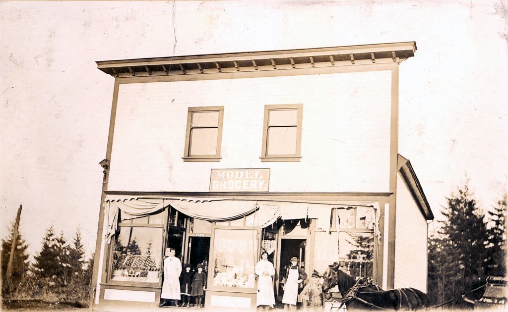
Model Grocery store
https://search.heritageburnaby.ca/link/museumdescription2651
- Repository
- Burnaby Village Museum
- Date
- 1916 (date of original)
- Collection/Fonds
- Burnaby Village Museum Photograph collection
- Description Level
- Item
- Physical Description
- 1 photograph : sepia ; 300 ppi
- Scope and Content
- Photograph of the Model Grocery store in East Burnaby.
- Repository
- Burnaby Village Museum
- Collection/Fonds
- Burnaby Village Museum Photograph collection
- Description Level
- Item
- Physical Description
- 1 photograph : sepia ; 300 ppi
- Scope and Content
- Photograph of the Model Grocery store in East Burnaby.
- Names
- Model Grocery
- Geographic Access
- 2nd Street
- 15th Avenue
- Accession Code
- BV004.115.26
- Access Restriction
- No restrictions
- Date
- 1916 (date of original)
- Media Type
- Photograph
- Historic Neighbourhood
- East Burnaby (Historic Neighbourhood)
- Planning Study Area
- Second Street Area
- Notes
- Title based on contents of photograph
Images
![Survey and Subdivision plans in New Westminster District Group 1 – Burnaby, [1905-1917] thumbnail](/media/hpo/_Data/_BVM_Cartographic_Material/1977/1977_0093_0022a_001.jpg?width=280)
Survey and Subdivision plans in New Westminster District Group 1 – Burnaby
https://search.heritageburnaby.ca/link/museumdescription6991
- Repository
- Burnaby Village Museum
- Date
- [1905-1917]
- Collection/Fonds
- Burnaby Village Museum Map collection
- Description Level
- File
- Physical Description
- 12 plans : 6 black ink on paper + 2 black & col. ink on paper + 4 graphite on paper
- Scope and Content
- Item consists of a large board of six New Westminster District subdivision plans mounted on one side and six New Westminster District subdivision plans mounted on the other side. Side A: 1. Plan drawn in graphite with markings in black ink "Surveyed for Mr. W. Wilson / Paterson Stat. B.C.E.R." . …
- Repository
- Burnaby Village Museum
- Collection/Fonds
- Burnaby Village Museum Map collection
- Description Level
- File
- Physical Description
- 12 plans : 6 black ink on paper + 2 black & col. ink on paper + 4 graphite on paper
- Material Details
- Scales [between 1:360 and 1:3168]
- Index number on edge of board reads: "22"
- Scope and Content
- Item consists of a large board of six New Westminster District subdivision plans mounted on one side and six New Westminster District subdivision plans mounted on the other side. Side A: 1. Plan drawn in graphite with markings in black ink "Surveyed for Mr. W. Wilson / Paterson Stat. B.C.E.R." . Plan includes subdivision of lots situated between B.C.E. Railway and Vancouver Road (Kingsway). (Geographic location: Burnaby) 2. Subdivision plan (no title) drawn in black ink with annotations in graphite. Plan covers District Lots 2, 4 and 6, west of North Road. Plan is stamped: "Albert J. Hill, Civil Engineer / and / Provincial Land Surveyor, / New Westminster, / B.C. (Geographic location: Burnaby) 3. Plan of "Portion of Municipality" with intials "RB" [sic] (handwritten in blue crayon). Plan covers the area north east of the City of New Westminster including District Lots 11, 13, 14, 12, 1 and 2. Plan is stamped: "Albert J. Hill, Civil Engineer / and / Provincial Land Surveyor, / New Westminster, / B.C. (Geographic location: Burnaby) 4."Plan / of Subdivision of / N.W.1/4 Lot 175 / Group 1 New West. Dist. / B.C. / Scale 4 chs = 1 in. " Plan is stamped: "Albert J. Hill, Civil Engineer / and / Provincial Land Surveyor, / New Westminster, / B.C. and initialed : "RB" [sic] (in blue pencil crayon) (Geographic location: Burnaby) 5. "Subdivision / of a Portion of / Lot 15 Group 1 / New Westminster Dist. / Scale 4 chs = 1 in". Plan provides numbered sudivisions - Lots 1 to 15 of District Lot 15 in red ink. (Geographic location: Burnaby) 6. Plan of "Central Park & / Vicinity" Plan includes subdivisions of District Lot 153 east of Central Park District Lot 151 and subdivision of District Lot 36 and 49 west of Boundary Road (Vancouver). Plan is stamped: "Albert J. Hill, Civil Engineer / and / Provincial Land Surveyor, / New Westminster, / B.C. and initialed : "RB" [sic] (in blue pencil crayon). (Geographic location: Burnaby) Side B: 1. Subdivision plan (no title) drawn in black ink. Plan identifies lots between Vancouver Road (Yale Road is crossed out and replaced with Vancouver Road) and B.C.E. Railway. "Scale 2 chs = 1 in" (Geographic location: Burnaby) 2. Plan of "Subdivision Lot 1 / Lot 69 Gr. 1 / Scale 30' = 1 " " Plan identifies Boundary Road, Still Creek and a Road Allowance between District Lot 118 and District Lot 69. Plan was "Surveyed for Burnaby Mun. Council / March 11th 1908 / G.K.B." (Geographic location: Burnaby) 3. Plan drawn in black ink (no title) showing a subdivision in Lot 25 with names "Newcomb", "Debeck" and "Armstrong" along with roads identified as Third Street, Cumberland Street, Armstrong Street and Cariboo [sic] Street and including Lots 27, 11 and 13.Plan is stamped: "Albert J. Hill, Civil Engineer / and / Provincial Land Surveyor, / New Westminster, / B.C. and initialed : "RB" [sic] (in blue pencil crayon). (Geographic location: Burnaby) 4. Handrawn subdivision plan in graphite titled: "Lot 13, Gr.1" with intials "RB" [sic] (handwritten in blue crayon). Plan is bordered by Armstrong Street (Lot 11, G.1), Cumberland St. (Lot 25, G.1) and Tenth Avenue (City Boundary). The plan is singed by "Albert J. Hill / P.L.S." and one of the subdivided lots is identified with the name: "W. Karrymann". (Geographic location: Burnaby) 5. Handrawn sketch in graphite titled: "Lot 88, Gr.1" with intials "RB" [sic] (handwritten in blue crayon). Plan appears to be a draft of a subdivision plan of a portion of District Lot 88 along Cumberland Road. The plan is signed: "16/7/17 _W.F. Draper [sic] / B.C.L.S." (Geographic location: Burnaby) 6. "Plan / of Subdivision / of Blocks 61, 62 and 2 / Lot 30 / Group 1 / N.W. Dist. / Scale 1ch = 1 in". Plan is intialed by: "PB" with a note: "Also see board 2 / for duplicate" (handwritten in blue crayon). (Geographic location: Burnaby)
- Creator
- Hill, Albert James
- Geographic Access
- Boundary Road
- Kingsway
- Cumberland Street
- Accession Code
- HV977.93.22
- Access Restriction
- No restrictions
- Reproduction Restriction
- No known restrictions
- Date
- [1905-1917]
- Media Type
- Cartographic Material
- Historic Neighbourhood
- Central Park (Historic Neighbourhood)
- Scan Resolution
- 300
- Scale
- 100
- Notes
- Title based on contents of file
- Scale is measured in chains and feet. (One chain equals 792 inches)
- The term "Lot" can also refer to a "District Lot”
- Some plans are stamped: "Albert J. Hill, Civil Engineer / and / Provincial Land Surveyor, / New Westminster, / B.C." and intialed: "RB" [sic]
Images
![Survey and Subdivision plans in New Westminster District Group 1 – Burnaby, [1905-1917] thumbnail](/media/hpo/_Data/_BVM_Cartographic_Material/1977/1977_0093_0022a_001.jpg)
