Narrow Results By
Subject
- Buildings - Civic - Museums 4
- Buildings - Residential 1
- Buildings - Residential - Houses 1
- Businesses - Real Estate Agencies 1
- Documentary Artifacts - Architectural Drawings 2
- Documentary Artifacts - Maps 1
- Exhibitions 1
- First Nations reserves - British Columbia 10
- Geographic Features - Forests 1
- Geographic Features - Roads 1
- Indigenous peoples - Indian Territory 8
Creator
- Bekins Moving and Storage Company Limited 1
- British Columbia Underwriters' Association 10
- Burnett, Geoffrey K. 1
- City Map and White Print Co. 1
- Coast Map and Blue Print Co. 1
- Dominion Map and Blueprint Co. 2
- Donald R. Erb and Associates Architects 1
- Draper, William Nelson 1
- Garden, Hermon and Burwell 3
- Garden, Hermon & Burwell 1
- Gauvreau, Narcisse B. 1
- Government of British Columbia - Department of Lands and Works 1
![Burnaby Village Museum - Presentation drawing, [1985] thumbnail](/media/hpo/_Data/_BVM_Architectural_Drawings/2019_0052_0091_001.jpg?width=280)
Burnaby Village Museum - Presentation drawing
https://search.heritageburnaby.ca/link/museumdescription11755
- Repository
- Burnaby Village Museum
- Date
- [1985]
- Collection/Fonds
- Century Park Museum Association fonds
- Description Level
- Item
- Physical Description
- 1 drawing : b&w print mounted on foamcore board 48 x 75 cm
- Scope and Content
- Item consists of a presentation drawing for proposed Burnaby Village Museum Expansion. (drawing is untitled). The drawing provides an overhead view of the site.
- Repository
- Burnaby Village Museum
- Collection/Fonds
- Century Park Museum Association fonds
- Description Level
- Item
- Physical Description
- 1 drawing : b&w print mounted on foamcore board 48 x 75 cm
- Scope and Content
- Item consists of a presentation drawing for proposed Burnaby Village Museum Expansion. (drawing is untitled). The drawing provides an overhead view of the site.
- Names
- Burnaby Village Museum
- Accession Code
- BV019.52.91
- Access Restriction
- No restrictions
- Reproduction Restriction
- May be restricted by third party rights
- Date
- [1985]
- Media Type
- Architectural Drawing
- Notes
- Title based on contents of drawing
Images
![Burnaby Village Museum - Presentation drawing, [1985] thumbnail](/media/hpo/_Data/_BVM_Architectural_Drawings/2019_0052_0091_001.jpg)
![Burnaby Village Museum - side street, [1985] thumbnail](/media/hpo/_Data/_BVM_Architectural_Drawings/2019_0052_0174_001.jpg?width=280)
Burnaby Village Museum - side street
https://search.heritageburnaby.ca/link/museumdescription17539
- Repository
- Burnaby Village Museum
- Date
- [1985]
- Collection/Fonds
- Century Park Museum Association fonds
- Description Level
- Item
- Physical Description
- 1 drawing : b&w print hand col. (pencil crayons) on paper 46 x 58 cm ; mounted on foamcore board 71 x 58 cm
- Scope and Content
- Item consists of a presentation drawing for the proposed Burnaby Village Museum Expansion. Title at bottom of drawing "Side Street". Illustration shows buildings on either side of a street with a four people walking down the centre of the road. A building on the right includes inscription on window…
- Repository
- Burnaby Village Museum
- Collection/Fonds
- Century Park Museum Association fonds
- Description Level
- Item
- Physical Description
- 1 drawing : b&w print hand col. (pencil crayons) on paper 46 x 58 cm ; mounted on foamcore board 71 x 58 cm
- Scope and Content
- Item consists of a presentation drawing for the proposed Burnaby Village Museum Expansion. Title at bottom of drawing "Side Street". Illustration shows buildings on either side of a street with a four people walking down the centre of the road. A building on the right includes inscription on windows reading "Village Hardware" and a building on the left appears to be a blacksmith shop.
- Subjects
- Buildings - Civic - Museums
- Names
- Burnaby Village Museum
- Accession Code
- BV019.52.174
- Access Restriction
- No restrictions
- Reproduction Restriction
- May be restricted by third party rights
- Date
- [1985]
- Media Type
- Architectural Drawing
- Notes
- Title based on contents of drawing
Images
![Burnaby Village Museum - side street, [1985] thumbnail](/media/hpo/_Data/_BVM_Architectural_Drawings/2019_0052_0174_001.jpg)
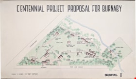
Centennial Project Proposal for Burnaby
https://search.heritageburnaby.ca/link/museumdescription11751
- Repository
- Burnaby Village Museum
- Date
- 1970
- Collection/Fonds
- Burnaby Centennial '71 Committee collection
- Description Level
- Item
- Physical Description
- 1 architectural drawing : black marker and pencil hand col. (pencil crayons) ; 58 x 1012 cm
- Scope and Content
- Item consists of a presentation drawing titled "Centennial Project Proposal for Burnaby" "Drawing 1". Site plan drawing of the future site of Heritage Village.
- Repository
- Burnaby Village Museum
- Collection/Fonds
- Burnaby Centennial '71 Committee collection
- Description Level
- Item
- Physical Description
- 1 architectural drawing : black marker and pencil hand col. (pencil crayons) ; 58 x 1012 cm
- Material Details
- Scale 3 inches = 100 Feet (approx)
- Scope and Content
- Item consists of a presentation drawing titled "Centennial Project Proposal for Burnaby" "Drawing 1". Site plan drawing of the future site of Heritage Village.
- Subjects
- Buildings - Civic - Museums
- Names
- Burnaby Village Museum
- Accession Code
- BV019.52.87
- Access Restriction
- No restrictions
- Reproduction Restriction
- May be restricted by third party rights
- Date
- 1970
- Media Type
- Architectural Drawing
- Notes
- Transcribed title from drawing
- Drawing is signed "Visti - 70"
Images

![Centennial Project Proposal for Burnaby, [1971] thumbnail](/media/hpo/_Data/_BVM_Architectural_Drawings/2019_0052_0175_001.jpg?width=280)
Centennial Project Proposal for Burnaby
https://search.heritageburnaby.ca/link/museumdescription17542
- Repository
- Burnaby Village Museum
- Date
- [1971]
- Collection/Fonds
- Burnaby Centennial '71 Committee collection
- Description Level
- Item
- Physical Description
- 1 architectural drawing : black ink with col. on board ; 57.5 x 101.5 cm
- Scope and Content
- Item consists of a presentation drawing titled "Centennial Project Proposal for Burnaby - Drawing 2". Drawing includes concept illustrations identified as "Museum Bldg" and "Entrance and Maintenance Bldg". This proposal was part of the Burnaby Centennial '71 Committee's commemorative project for "H…
- Repository
- Burnaby Village Museum
- Collection/Fonds
- Burnaby Centennial '71 Committee collection
- Description Level
- Item
- Physical Description
- 1 architectural drawing : black ink with col. on board ; 57.5 x 101.5 cm
- Scope and Content
- Item consists of a presentation drawing titled "Centennial Project Proposal for Burnaby - Drawing 2". Drawing includes concept illustrations identified as "Museum Bldg" and "Entrance and Maintenance Bldg". This proposal was part of the Burnaby Centennial '71 Committee's commemorative project for "Heritage Village". Elworth house is identified as the "Museum Bldg". The illustration was created by Rudy Kovach of "Hopping/Kovach/Grinnell" Design consultants.
- Accession Code
- BV019.52.175
- Access Restriction
- No restrictions
- Reproduction Restriction
- May be restricted by third party rights
- Date
- [1971]
- Media Type
- Architectural Drawing
- Scan Resolution
- 72
- Scan Date
- 2021-11-10
- Notes
- Title based on contents of drawing
- See also photograph BV005.54.789
Images
![Centennial Project Proposal for Burnaby, [1971] thumbnail](/media/hpo/_Data/_BVM_Architectural_Drawings/2019_0052_0175_001.jpg)

Heritage Park - Contract 2 - original site plan and buildings
https://search.heritageburnaby.ca/link/museumdescription11678
- Repository
- Burnaby Village Museum
- Date
- June 1971
- Collection/Fonds
- Burnaby Centennial '71 Committee collection
- Description Level
- File
- Physical Description
- 6 architectural drawings : blackline prints ; 61 x 92 cm
- Scope and Content
- File consists of architectural drawings of Heritage Park covering Contracts number one, two and three. Plans are titled: "Heritage Park / for the Burnaby Centennial Committee / Contract 2 / Job no. 71-006", drawings "A-1 / Site Plan"; "A-2 / Floor Plan / of Buildings / I.G.H. & Q / Contract No. 2";…
- Repository
- Burnaby Village Museum
- Collection/Fonds
- Burnaby Centennial '71 Committee collection
- Description Level
- File
- Physical Description
- 6 architectural drawings : blackline prints ; 61 x 92 cm
- Material Details
- Scales differ
- Scope and Content
- File consists of architectural drawings of Heritage Park covering Contracts number one, two and three. Plans are titled: "Heritage Park / for the Burnaby Centennial Committee / Contract 2 / Job no. 71-006", drawings "A-1 / Site Plan"; "A-2 / Floor Plan / of Buildings / I.G.H. & Q / Contract No. 2"; "A-3 / Elevations / Contract No. 2"; "A-4 / Elevation, / Section & / Details / Contract No. 2"; "A-5 / Building / Sections / Contract No. 2" ; "Structural / Details / Contract No. 2". Site plan includes proposed buildings within Heritage Village identified as: Building A (Admission Gate and entrance); Building B (Baker house); Buildng C (Baker house garage); Building D (Bandstand); Building E (Gas Station); Buildng F (Fire Hall); Building G (East side of Hill Street including Print Shop, Bicycle Shop, General Store, Buggy Shop); Building H (West side of Hill Street including Ice Cream Parlour, Kitchen, Bank, Dentist, Apothecary, Service); Building I (East side of Hill Street including Harness Shop and Blacksmith shop); Building J (Future Exhibits); Building K (Municipal Hall); Building L (Service & Adminstration); Building M (Sawmill); Building N (Shake Splitting and Saw Shop); Building O (Log Cabin); Building P (Shelter next to Farm Yard); Building Q (Tram and Tram Station);
- Names
- Burnaby Village Museum
- Accession Code
- BV019.52.14
- Access Restriction
- Subject to FIPPA
- Reproduction Restriction
- Reproductions subject to FIPPA
- Date
- June 1971
- Media Type
- Architectural Drawing
- Scan Resolution
- 600
- Scan Date
- 2023-03-27
- Notes
- Transcribed Title
- Tag taped to the A-6 reads: "6501 Deer Lake Avenue / Heritage Village 1971" and on verso of tag "Heritage Park / (Deer Lake & Can. Way)"
- Title on verso of plan reads: "MISC._DWGS.--ORGINAL_SITE_PLAN_+_BUILDINGS / "HERITAGE_PARK"--CENTENNIAL_COMMITTEE_JUNE_1971"
Images


![Heritage Village - Master Plan Proposal, [1971] thumbnail](/media/hpo/_Data/_BVM_Architectural_Drawings/2019_0052_0085_001.jpg?width=280)
Heritage Village - Master Plan Proposal
https://search.heritageburnaby.ca/link/museumdescription11749
- Repository
- Burnaby Village Museum
- Date
- [1971]
- Collection/Fonds
- Burnaby Centennial '71 Committee collection
- Description Level
- Item
- Physical Description
- 1 architectural drawing : black ink and pencil hand col. (markers) ; mounted on board 61 X 92 cm
- Scope and Content
- Item consists of a presentation drawing of "Heritage Village / Master Plan Proposal" created by Hopping, Kovach and Grinnell Design Consultants Ltd.
- Repository
- Burnaby Village Museum
- Collection/Fonds
- Burnaby Centennial '71 Committee collection
- Description Level
- Item
- Physical Description
- 1 architectural drawing : black ink and pencil hand col. (markers) ; mounted on board 61 X 92 cm
- Material Details
- Not drawn to scale
- Scope and Content
- Item consists of a presentation drawing of "Heritage Village / Master Plan Proposal" created by Hopping, Kovach and Grinnell Design Consultants Ltd.
- Subjects
- Buildings - Civic - Museums
- Names
- Burnaby Village Museum
- Accession Code
- BV019.52.85
- Access Restriction
- No restrictions
- Reproduction Restriction
- May be restricted by third party rights
- Date
- [1971]
- Media Type
- Architectural Drawing
- Notes
- Transcribed title
Images
![Heritage Village - Master Plan Proposal, [1971] thumbnail](/media/hpo/_Data/_BVM_Architectural_Drawings/2019_0052_0085_001.jpg)
![Heritage Village - Master Plan Proposal, [1971] thumbnail](/media/hpo/_Data/_BVM_Architectural_Drawings/2019_0052_0086_001.jpg?width=280)
Heritage Village - Master Plan Proposal
https://search.heritageburnaby.ca/link/museumdescription11750
- Repository
- Burnaby Village Museum
- Date
- [1971]
- Collection/Fonds
- Burnaby Centennial '71 Committee collection
- Description Level
- Item
- Physical Description
- 1 architectural drawing : black ink and pencil hand col. (markers) ; mounted on board 61 X 92 cm
- Scope and Content
- Item consists of a presentation drawing of "Heritage Village / Master Plan Proposal" created by Hopping, Kovach and Grinnell Design Consultants Ltd.
- Repository
- Burnaby Village Museum
- Collection/Fonds
- Burnaby Centennial '71 Committee collection
- Description Level
- Item
- Physical Description
- 1 architectural drawing : black ink and pencil hand col. (markers) ; mounted on board 61 X 92 cm
- Material Details
- Not drawn to scale
- Scope and Content
- Item consists of a presentation drawing of "Heritage Village / Master Plan Proposal" created by Hopping, Kovach and Grinnell Design Consultants Ltd.
- Subjects
- Buildings - Civic - Museums
- Names
- Burnaby Village Museum
- Accession Code
- BV019.52.86
- Access Restriction
- No restrictions
- Reproduction Restriction
- May be restricted by third party rights
- Date
- [1971]
- Media Type
- Architectural Drawing
- Notes
- Transcribed title
Images
![Heritage Village - Master Plan Proposal, [1971] thumbnail](/media/hpo/_Data/_BVM_Architectural_Drawings/2019_0052_0086_001.jpg)

Fire insurance key plan - Greater Vancouver - Volume XIX - Municipality of Burnaby
https://search.heritageburnaby.ca/link/museumdescription17799
- Repository
- Burnaby Village Museum
- Date
- 1927
- Collection/Fonds
- Burnaby Village Museum Map collection
- Description Level
- Item
- Physical Description
- 1 plan on 1 sheet : col. lithographic print ; 64 x 54 cm
- Scope and Content
- Item consists of a one page fire insurance key plan titled "Greater Vancouver / Volume XIX / Municipality / of Burnaby / Key Plan" surveyed May 1927. Key plan from compilation, "Insurance Plans of Greater Vancouver Plan No. 11, Volumes 15 to 19 Burnaby".
- Repository
- Burnaby Village Museum
- Collection/Fonds
- Burnaby Village Museum Map collection
- Description Level
- Item
- Physical Description
- 1 plan on 1 sheet : col. lithographic print ; 64 x 54 cm
- Material Details
- Scale [1:6000]
- Scope and Content
- Item consists of a one page fire insurance key plan titled "Greater Vancouver / Volume XIX / Municipality / of Burnaby / Key Plan" surveyed May 1927. Key plan from compilation, "Insurance Plans of Greater Vancouver Plan No. 11, Volumes 15 to 19 Burnaby".
- Publisher
- Plan Department of Fire Branch of British Columbia Underwriters' Association
- Accession Code
- BV987.1.70
- Access Restriction
- No restrictions
- Reproduction Restriction
- May be restricted by third party rights
- Date
- 1927
- Media Type
- Cartographic Material
- Historic Neighbourhood
- Fraser Arm (Historic Neighbourhood)
- Planning Study Area
- Big Bend Area
- Scan Resolution
- 400
- Scan Date
- 2021-11-17
- Notes
- Title based on contents of item
- Scale 500 feet = 1 inch
- These plans were removed from a bound book with labels on cover page reading: "Plan No. 90 / THIS INSURANCE PLAN / of / Vancouver VOLUME "8" / IN THE PROPERTY OF THE / British Columbia Insurance Underwriter's Association / Vancouver B.C. / AND IS LOANED / MELVILLE F. THOMSON CO. .../ Date May 26th, 1934"; / "Plan No. 74 / THIS INSURANCE PLAN / OF / VANCOUVER VOLUME "9"" / Plan No. 11 / THIS INSURANCE PLAN / OF / BURNABY VOLUMES 15-19" / "THIS PLAN IS THE PROPERTY OF / THE / BRITISH LAW INSURANCE COMPANY / LIMITED"
- Does not include the corresponding key plan page or associated plans numbered 1901 to 1914
- Contact Burnaby Village Museum to view associated fire insurance plans
Zoomable Images

Fire insurance key plan - Greater Vancouver - Volume XIX - Municipality of Burnaby, 1927
Zoom into Image![Municipality of Burnaby - Volume XV and Volume XVIII, 1927-[1940] thumbnail](/media/hpo/_Data/_BVM_Artifacts/1972/1972_0111_0004_003.jpg?width=280)
Municipality of Burnaby - Volume XV and Volume XVIII
https://search.heritageburnaby.ca/link/museumdescription8682
- Repository
- Burnaby Village Museum
- Date
- 1927-[1940]
- Collection/Fonds
- Burnaby Village Museum Map collection
- Description Level
- File
- Physical Description
- 4 plans on 4 sheets: col. lithographic prints ; 63.5 x 53.5 cm folded to 53 x 31.5 cm
- Scope and Content
- File consists of four pages of plans removed from a bound book containing a series of fire insurance plans of the Municipality of Burnaby. Plan "1518" and "1519" are from "GREATER VANCOUVER B.C. / VOLUME XV / Municipality of Burnaby / May, 1927". Plan "1518" covers District Lot 116 and Plan "1519"…
- Repository
- Burnaby Village Museum
- Collection/Fonds
- Burnaby Village Museum Map collection
- Description Level
- File
- Physical Description
- 4 plans on 4 sheets: col. lithographic prints ; 63.5 x 53.5 cm folded to 53 x 31.5 cm
- Material Details
- Scale [1:600]
- Scope and Content
- File consists of four pages of plans removed from a bound book containing a series of fire insurance plans of the Municipality of Burnaby. Plan "1518" and "1519" are from "GREATER VANCOUVER B.C. / VOLUME XV / Municipality of Burnaby / May, 1927". Plan "1518" covers District Lot 116 and Plan "1519" covers District Lot 121. Plan "1802" and plan "1803" are from "GREATER VANCOUVER B.C. / VOLUME XVIII / Municipality of Burnaby / May, 1927". Both plans "1802" and "1803" cover District Lot 153.
- Responsibility
- British Columbia Underwriters' Association
- Accession Code
- HV972.111.4
- Access Restriction
- No restrictions
- Reproduction Restriction
- May be restricted by third party rights
- Date
- 1927-[1940]
- Media Type
- Cartographic Material
- Historic Neighbourhood
- Vancouver Heights (Historic Neighbourhood)
- Central Park (Historic Neighbourhood)
- Planning Study Area
- Willingdon Heights Area
- Marlborough Area
- Scan Resolution
- 400
- Scan Date
- 2021-11-18
- Notes
- Title based on content of plans
- See also BV987.1.70d for revised versions of plans
- Scale is measured 1 inch = 50 feet
- Contact Burnaby Village Museum to access plans 1518 and 1519 (these plans have revisions on top - date of revisions is uncertain)
Images
![Municipality of Burnaby - Volume XV and Volume XVIII, 1927-[1940] thumbnail](/media/hpo/_Data/_BVM_Artifacts/1972/1972_0111_0004_003.jpg)

![1892 Burnaby Centennial, [1992] thumbnail](/media/hpo/_Data/_BVM_Cartographic_Material/2013/2013_0008_0001_001.jpg?width=280)
1892 Burnaby Centennial
https://search.heritageburnaby.ca/link/museumdescription8704
- Repository
- Burnaby Village Museum
- Date
- [1992]
- Collection/Fonds
- Burnaby Village Museum Map collection
- Description Level
- Item
- Physical Description
- 1 map : blueline print ; 71 cm x 119 cm
- Scope and Content
- A birds eye view map of Burnaby, drawn by Mark Lewis, Parks staff, as a Parks-Maintenance Centennial Project for the 1892 - 1992 Burnaby Centennial. It features wildlife found in Burnaby and highlights civic buildings, parks and other prominent structures of the time. This is not a scale map.
- Repository
- Burnaby Village Museum
- Collection/Fonds
- Burnaby Village Museum Map collection
- Description Level
- Item
- Physical Description
- 1 map : blueline print ; 71 cm x 119 cm
- Material Details
- "1892 BURNABY/ CENTENNIAL 1992" printed in a banner across the top of the map Burnaby Centennial logo is located in the lower right side. "ALL WILDLIFE SHOWN CAN STILL / BE FOUND IN THE BURNABY AREA" printed in lower right corner "DRAWN BY / MARK LEWIS / A PARKS-MAINTENANCE / CENTENNIAL PROJECT" printed in the very lower right corner.
- The map is dark blue ink, there is no colour.
- Scope and Content
- A birds eye view map of Burnaby, drawn by Mark Lewis, Parks staff, as a Parks-Maintenance Centennial Project for the 1892 - 1992 Burnaby Centennial. It features wildlife found in Burnaby and highlights civic buildings, parks and other prominent structures of the time. This is not a scale map.
- History
- Drawn by Mark Lewis of the Parks-Maintenance Dept for the 1882 - 1992 Centennial of Burnaby. Mark always loved birds-eye maps, and showed this map to his supervisors while the work was still in progress. They suggested the map could be a Parks Maintenance Centennial Project. Mark agreed, and completed the map, including Burnaby landmarks and sketches of wildlife. Several copies of the map were given to schools so students could colour them.
- Creator
- Lewis, Mark
- Accession Code
- BV013.8.1
- Access Restriction
- No restrictions
- Reproduction Restriction
- No known restrictions
- Date
- [1992]
- Media Type
- Cartographic Material
- Scan Resolution
- 300
- Scan Date
- 05-Jun-2013
- Scale
- 96
- Notes
- Transcribed title
Images
![1892 Burnaby Centennial, [1992] thumbnail](/media/hpo/_Data/_BVM_Cartographic_Material/2013/2013_0008_0001_001.jpg)
![Bird's eye view of New Westminster, Burnaby and Vancouver, [ca. 1911] thumbnail](/media/hpo/_Data/_BVM_Cartographic_Material/1983/1983_0012_0001_002%20Web.jpg?width=280)
Bird's eye view of New Westminster, Burnaby and Vancouver
https://search.heritageburnaby.ca/link/museumdescription8199
- Repository
- Burnaby Village Museum
- Date
- [ca. 1911]
- Collection/Fonds
- Burnaby Village Museum Map collection
- Description Level
- Item
- Physical Description
- 1 map : hand painted ; 65.5 x 99 cm
- Scope and Content
- An untitled monochromatic grayscale map of a developer's bird's eye view looking north west from Burnaby Mountain. View includes Burnaby, New Westminster, Vancouver with the North shore in the distance. Burnaby neighbourhood subdivisions of "Burnaby Heights" and "Buena Vista" are featured near the…
- Repository
- Burnaby Village Museum
- Collection/Fonds
- Burnaby Village Museum Map collection
- Description Level
- Item
- Physical Description
- 1 map : hand painted ; 65.5 x 99 cm
- Scope and Content
- An untitled monochromatic grayscale map of a developer's bird's eye view looking north west from Burnaby Mountain. View includes Burnaby, New Westminster, Vancouver with the North shore in the distance. Burnaby neighbourhood subdivisions of "Burnaby Heights" and "Buena Vista" are featured near the centre of the map. These neighbourhood subdivisions were marketed by Real Estate Agents Liebly & Blumer in 1911. Roads, buildings, factories, railways and bridges are identified on the map.
- Subjects
- Businesses - Real Estate Agencies
- Responsibility
- Leibly & Blumer Realty Co. Incorporated
- Accession Code
- HV983.12.1
- Access Restriction
- No restrictions
- Reproduction Restriction
- No known restrictions
- Date
- [ca. 1911]
- Media Type
- Cartographic Material
- Historic Neighbourhood
- East Burnaby (Historic Neighbourhood)
- Vancouver Heights (Historic Neighbourhood)
- Planning Study Area
- Cariboo-Armstrong Area
- Burnaby Heights Area
- Scan Resolution
- 300
- Scan Date
- December 2020
- Scale
- 100
- Notes
- Title based on contents of map
- Note in pencil on verso of photograph reads: "Make tint block of Buena Vista / Blocks only as shown in lots"
Zoomable Images
![Bird's eye view of New Westminster, Burnaby and Vancouver, [ca. 1911] thumbnail](/media/hpo/_Data/_BVM_Cartographic_Material/1983/1983_0012_0001_001_seadragon/1983_0012_0001_001.jpg?w=280)

Commercial Map of Greater Vancouver and District
https://search.heritageburnaby.ca/link/museumdescription9552
- Repository
- Burnaby Village Museum
- Date
- July 1921
- Collection/Fonds
- Burnaby Village Museum Map collection
- Description Level
- Item
- Physical Description
- 1 map : col. lithograph mounted on linen ; 107 x 138 cm
- Scope and Content
- Commercial map of Greater Vancouver and District. Map depicts district lots, railroads, electric railways, streets, street car stops, schools, buildings, postal block numbers, parks and First Nations reserves. Map covers the geographcial areas of Vancouver, Burnaby, New Westminster, portions of Ric…
- Repository
- Burnaby Village Museum
- Collection/Fonds
- Burnaby Village Museum Map collection
- Description Level
- Item
- Physical Description
- 1 map : col. lithograph mounted on linen ; 107 x 138 cm
- Material Details
- Includes Legend and Index
- Scope and Content
- Commercial map of Greater Vancouver and District. Map depicts district lots, railroads, electric railways, streets, street car stops, schools, buildings, postal block numbers, parks and First Nations reserves. Map covers the geographcial areas of Vancouver, Burnaby, New Westminster, portions of Richmond, West Vancouver, North Vancouver, and Surrey with half mile circles that radiate from Vancouver City Hall on the corner of Main and Hastings. Bottom of map includes an index of street names, along with their corresponding map grid locations. The map is bordered by Marine Drive to the west, North Road to the east, Dempsey Street to the north and 20th Road to the south.
- History
- Bought by donor at thrift store years ago. No known provenance.
- Publisher
- Produced by Photo - Lithography, Colonist , Victoria, B.C.
- Geographic Access
- Vancouver
- Accession Code
- BV018.24.1
- Access Restriction
- No restrictions
- Reproduction Restriction
- No known restrictions
- Date
- July 1921
- Media Type
- Cartographic Material
- Scan Resolution
- 300
- Scan Date
- 16-Jun-20
- Scale
- 100
- Notes
- Transcribed title
- Title on map reads: "COMMERCIAL MAP / OF / GREATER VANCOUVER / AND / DISTRICT / Compiled and Published by / The Vancouver Map & Blueprint Co. Ltd. / 441 Seymour St. Vancouver B.C. / July, 1921".
Images

![Copy of Official British Columbia Road Maps, [193-] thumbnail](/media/hpo/_Data/_BVM_Cartographic_Material/1972/1972_0179_0001_001.jpg?width=280)
Copy of Official British Columbia Road Maps
https://search.heritageburnaby.ca/link/museumdescription18945
- Repository
- Burnaby Village Museum
- Date
- [193-]
- Collection/Fonds
- Burnaby Village Museum Map collection
- Physical Description
- 1 map : lithographic print on sheet ; 43 x 56 cm folded to 22 x 11 cm
- Scope and Content
- Item consists of Road maps of British Columbia presented by Union Oil Company of Canada Limited. Includes seventeen maps printed on both sides of sheet. One side of sheet includes ten separate road maps titled "Cariboo"; "Chilcotin Plateau"; "150 Mile House to Prince George"; "Prince George - Burns…
- Repository
- Burnaby Village Museum
- Collection/Fonds
- Burnaby Village Museum Map collection
- Physical Description
- 1 map : lithographic print on sheet ; 43 x 56 cm folded to 22 x 11 cm
- Material Details
- Scale not defined
- Scope and Content
- Item consists of Road maps of British Columbia presented by Union Oil Company of Canada Limited. Includes seventeen maps printed on both sides of sheet. One side of sheet includes ten separate road maps titled "Cariboo"; "Chilcotin Plateau"; "150 Mile House to Prince George"; "Prince George - Burns Lake"; "Burns Lake - Hazelton"; "Similkameen - Nicola"; "Salmon Arm to Revelstoke"; "Ashcroft to Salmon Arm / Kamloops to Vernon"; "Okanagan Valley"; "Boundary District". Other side of sheet includes seven road maps titled "Vancouver Island"; "Vancouver to Yale"' "Fraser Canyon Section Cariboo Road"; "Lytton to 150 Mile House"; "Arrow and Kootenay Lakes"; "The Kootenays"; "Columbia Valley". When folded, cover of maps reads "COPY OF / OFFICIAL / BRITISH COLUMBIA / ROAD-MAPS" / Presented by / UNION OIL / COMPANY / of Canada Ltd."; verso of cover includes advertisement for Union Motor oil "MOTORITE"; inside cover includes advertisement for Union Gasoline with title reading "See Canada's Evergreen Playground".
- Responsibility
- Union Oil Company of Canada Limited
- Accession Code
- HV972.179.1
- Access Restriction
- No restrictions
- Reproduction Restriction
- No known restrictions
- Date
- [193-]
- Media Type
- Cartographic Material
- Scan Resolution
- 600
- Scan Date
- 2023-08-17
- Notes
- Title based on contents of map
Images
![Copy of Official British Columbia Road Maps, [193-] thumbnail](/media/hpo/_Data/_BVM_Cartographic_Material/1972/1972_0179_0001_001.jpg)


Fire insurance key plan - Greater Vancouver - Volume XVI - Municipality of Burnaby
https://search.heritageburnaby.ca/link/museumdescription17796
- Repository
- Burnaby Village Museum
- Date
- 1927
- Collection/Fonds
- Burnaby Village Museum Map collection
- Description Level
- Item
- Physical Description
- 2 plans on 2 sheets: col. lithographic print ; 64 x 54 cm
- Scope and Content
- Item consists of a two page fire insurance key plan titled "Greater Vancouver / Volume XVI / Municipality / of Burnaby / Key Plan" surveyed May 1927. Volume XVI includes a two page Key Plan (C and D). .
- Repository
- Burnaby Village Museum
- Collection/Fonds
- Burnaby Village Museum Map collection
- Description Level
- Item
- Physical Description
- 2 plans on 2 sheets: col. lithographic print ; 64 x 54 cm
- Scope and Content
- Item consists of a two page fire insurance key plan titled "Greater Vancouver / Volume XVI / Municipality / of Burnaby / Key Plan" surveyed May 1927. Volume XVI includes a two page Key Plan (C and D). .
- Publisher
- Plan Department of Fire Branch of British Columbia Underwriters Association
- Accession Code
- BV987.1.70
- Access Restriction
- No restrictions
- Reproduction Restriction
- May be restricted by third party rights
- Date
- 1927
- Media Type
- Cartographic Material
- Scan Resolution
- 400
- Scan Date
- 11/17/2021
- Notes
- Title based on contents of item
- Item "GREATER VANCOUVER / VOLUME XVI / MUNICIPALITY OF / BURNABY / KEY PLAN" does not include associated numbered plans (1601 to 1651)
- These plans were removed from a bound book with labels on cover page reading: "Plan No. 90 / THIS INSURANCE PLAN / of / Vancouver VOLUME "8" / IN THE PROPERTY OF THE / British Columbia Insurance Underwriter's Association / Vancouver B.C. / AND IS LOANED / MELVILLE F. THOMSON CO. .../ Date May 26th, 1934"; / "Plan No. 74 / THIS INSURANCE PLAN / OF / VANCOUVER VOLUME "9"" / Plan No. 11 / THIS INSURANCE PLAN / OF / BURNABY VOLUMES 15-19" / "THIS PLAN IS THE PROPERTY OF / THE / BRITISH LAW INSURANCE COMPANY / LIMITED"
Zoomable Images

Fire insurance key plan - Greater Vancouver - Volume XVI - Municipality of Burnaby, 1927
Zoom into Image
![Highways map of British Columbia, Alberta and adjacent states, [1930] thumbnail](/media/hpo/_Data/_BVM_Cartographic_Material/1977/1977_0037_0187_001.jpg?width=280)
Highways map of British Columbia, Alberta and adjacent states
https://search.heritageburnaby.ca/link/museumdescription9668
- Repository
- Burnaby Village Museum
- Date
- [1930]
- Collection/Fonds
- Burnaby Village Museum Map collection
- Description Level
- Item
- Physical Description
- 1 map : col. lithographic print ; both sides ; 89.5 x 58 cm, folded to 11.5 x 20 cm
- Scope and Content
- Double sided road map published by Imperial Oil, Ltd. and featuring the main travelled highway routes of British Columbia, Alberta and the Northwestern-most states of the United States of America. The map is a colour lithograph. The main map is green, with the highways highlighted in red. The litho…
- Repository
- Burnaby Village Museum
- Collection/Fonds
- Burnaby Village Museum Map collection
- Description Level
- Item
- Physical Description
- 1 map : col. lithographic print ; both sides ; 89.5 x 58 cm, folded to 11.5 x 20 cm
- Material Details
- Scale 1 inch = 20 miles
- A.R. THOMSON / CHIEF CARTOGRAPHER
- Scope and Content
- Double sided road map published by Imperial Oil, Ltd. and featuring the main travelled highway routes of British Columbia, Alberta and the Northwestern-most states of the United States of America. The map is a colour lithograph. The main map is green, with the highways highlighted in red. The lithograph was created in Canada by Rolph Clark Stone Ltd in Toronto. The opposite side of the map features inset maps of the following: the Trans-Canada Highway, the highway between Prince Rupert and Prince George, the highway through the Canadian Rockies, and the highway through the Peace River District. Small city plan maps of highways through major cities, as well as advertisements for Imperial Oil products, are also found on the opposite side of the main map. This map is one of four produced by Imperial Oil that covered the most populated areas of Canada from coast to coast and paralleled Imperial Oil's distribution service.
- Creator
- Thomson, A.R.
- Publisher
- Imperial Oil Limited
- Accession Code
- HV977.37.187
- Access Restriction
- No restrictions
- Reproduction Restriction
- No known restrictions
- Date
- [1930]
- Media Type
- Cartographic Material
- Scan Resolution
- 600
- Scan Date
- 2023-11-10
- Notes
- Title based on content of map
Zoomable Images
![Highways map of British Columbia, Alberta and adjacent states, [1930] thumbnail](/media/hpo/_Data/_BVM_Cartographic_Material/1977/1977_0037_0187_003_seadragon/1977_0037_0187_003.jpg?w=280)

![Indexed guide map of the City of Vancouver and suburbs, [1920] thumbnail](/media/hpo/_Data/_BVM_Cartographic_Material/1975/1975_0061_0013_001.jpg?width=280)
Indexed guide map of the City of Vancouver and suburbs
https://search.heritageburnaby.ca/link/museumdescription8678
- Repository
- Burnaby Village Museum
- Date
- [1920]
- Collection/Fonds
- Burnaby Village Museum Map collection
- Description Level
- Item
- Physical Description
- 1 map + textual record : col. lithographic print on paper ; 51.5 x 71 cm folded to 21 x 10 cm
- Scope and Content
- Item consists of a fold out map entitled "Indexed Guide Map of Vancouver and Suburbs" with index. Map includes concentric circles raditating out from Vancouver City Hall on corner of Hastings Street and Main Street; electric railways are indicated by heavy red lines in centres of streets. Includes …
- Repository
- Burnaby Village Museum
- Collection/Fonds
- Burnaby Village Museum Map collection
- Description Level
- Item
- Physical Description
- 1 map + textual record : col. lithographic print on paper ; 51.5 x 71 cm folded to 21 x 10 cm
- Material Details
- Scale [1:47520]
- Index on 4 pages within cardstock cover with advertisements on verso
- Scope and Content
- Item consists of a fold out map entitled "Indexed Guide Map of Vancouver and Suburbs" with index. Map includes concentric circles raditating out from Vancouver City Hall on corner of Hastings Street and Main Street; electric railways are indicated by heavy red lines in centres of streets. Includes old and new street names. Index includes a District Lot Index and Street Index.
- Publisher
- Vancouver Map and Blue Print Company
- Accession Code
- HV975.61.13
- Access Restriction
- No restrictions
- Reproduction Restriction
- No known restrictions
- Date
- [1920]
- Media Type
- Cartographic Material
- Textual Record
- Publisher Series
- 6th edition revised June 1920
- Scan Resolution
- 600
- Scan Date
- 2023-11-10
- Notes
- Title based on contents of map
- Cover of booklet reads: "INDEXED / Guide Map / of the CITY of / VANCOUVER / and / SUBURBS / Compiled and Published by / The Vancouver Map & Blue Print Co. / ...."INTERNATIONAL / BOOK SHOP / Cor. Columbia and Hastings Sts._Vancouver, B.C.".
Documents
Zoomable Images
![Indexed guide map of the City of Vancouver and suburbs, [1920] thumbnail](/media/hpo/_Data/_BVM_Cartographic_Material/1975/1975_0061_0013_002_seadragon/1975_0061_0013_002.jpg?w=280)

Indexed guide map of the city of Vancouver and Suburbs
https://search.heritageburnaby.ca/link/museumdescription8694
- Repository
- Burnaby Village Museum
- Date
- 1914
- Collection/Fonds
- Burnaby Village Museum Map collection
- Description Level
- Item
- Physical Description
- 1 map + textual record : col. lithographic print on paper ; 55 x 78 cm on sheet 58.5 x 82 cm folded to 20 x 10 cm
- Scope and Content
- Item consists of a map "Indexed Guide Map of the City of Vancouver and Suburbs compiled and published by The Vancouver Map and Blueprint Co. Ltd. Map shows district lots, blocks and boundaries between City of Vancouver, Point Grey, South Vancouver, Burnaby, New Westminster and parts of Richmond, No…
- Repository
- Burnaby Village Museum
- Collection/Fonds
- Burnaby Village Museum Map collection
- Description Level
- Item
- Physical Description
- 1 map + textual record : col. lithographic print on paper ; 55 x 78 cm on sheet 58.5 x 82 cm folded to 20 x 10 cm
- Material Details
- Scale not defined
- Map is folded into booklet form
- Scope and Content
- Item consists of a map "Indexed Guide Map of the City of Vancouver and Suburbs compiled and published by The Vancouver Map and Blueprint Co. Ltd. Map shows district lots, blocks and boundaries between City of Vancouver, Point Grey, South Vancouver, Burnaby, New Westminster and parts of Richmond, North Vancouver and West Vancouver. Concentric cirlces indicate the distance in miles from the intersection of Main Street and Hastings Street, Vancouver in intervals of 1/2 mile. Map is folded into booklet form and includes a four page index with cardstock cover. Index page 1 is titled "Hotels"; page 2 is titled "District Lot Index"; pages 3-8 "Street Index".
- Publisher
- Vancouver Map and Blueprint Company Limited
- Edition
- 5th Edition revised to June 1914
- Geographic Access
- Vancouver
- Accession Code
- HV983.9.18
- Date
- 1914
- Media Type
- Cartographic Material
- Scan Resolution
- 600
- Scan Date
- 2023-08-17
- Notes
- Transcribed title from map and cover
- Sticker adhered to front cover of index of two lions "Service / "WE GIVE IT" / WESTERN SPECIALTY / LIMITED/ STATIONERS AND PRINTERS / VANCOUVER - B.C."
Documents
Zoomable Images

![Indexed map of Greater Vancouver, [193-] thumbnail](/media/hpo/_Data/_BVM_Cartographic_Material/1976/1976_0026_0001_001.jpg?width=280)
Indexed map of Greater Vancouver
https://search.heritageburnaby.ca/link/museumdescription8201
- Repository
- Burnaby Village Museum
- Date
- [193-]
- Collection/Fonds
- Burnaby Village Museum Map collection
- Description Level
- Item
- Physical Description
- 1 map + 1 p. textual records : b&w lithographic print on 1 sheet ; 46 x 41 cm folded to 23 x 10 cm
- Scope and Content
- Item consists of a promotional brochure for Bekins Moving and Storage, with an indexed map of Greater Vancouver showing distances from the Bekins building located at Pender Street and Beatty Street on one side, and text and images advertising the company's services and facilities on the other side.…
- Repository
- Burnaby Village Museum
- Collection/Fonds
- Burnaby Village Museum Map collection
- Description Level
- Item
- Physical Description
- 1 map + 1 p. textual records : b&w lithographic print on 1 sheet ; 46 x 41 cm folded to 23 x 10 cm
- Material Details
- Scale not defined
- Printing on two sides of sheet
- Folded into eight sections
- Scope and Content
- Item consists of a promotional brochure for Bekins Moving and Storage, with an indexed map of Greater Vancouver showing distances from the Bekins building located at Pender Street and Beatty Street on one side, and text and images advertising the company's services and facilities on the other side. Cover of folded map reads "Indexed Map of Greater Vancouver / The Great Northwest for Opportunity / Compliments of / Bekins Moving and / Storage Co.".
- Responsibility
- Bekins Moving and Storage Company Limited
- Accession Code
- HV976.26.1
- Access Restriction
- No restrictions
- Reproduction Restriction
- No known restrictions
- Date
- [193-]
- Media Type
- Cartographic Material
- Textual Record
- Scan Resolution
- 600
- Scan Date
- 2023-08-17
- Notes
- Title based on contents of map
Zoomable Images
![Indexed map of Greater Vancouver, [193-] thumbnail](/media/hpo/_Data/_BVM_Cartographic_Material/1976/1976_0026_0001_001_seadragon/1976_0026_0001_001.jpg?w=280)

Map of Municipality of Burnaby
https://search.heritageburnaby.ca/link/museumdescription8200
- Repository
- Burnaby Village Museum
- Date
- 1921
- Collection/Fonds
- Burnaby Village Museum Map collection
- Description Level
- Item
- Physical Description
- 1 map : lithographic print, b&w ; 83 x 56 cm
- Scope and Content
- Item consists of a map of the Municipality of Burnaby compiled and published by Dominion Blueprint & Map Company.
- Repository
- Burnaby Village Museum
- Collection/Fonds
- Burnaby Village Museum Map collection
- Description Level
- Item
- Physical Description
- 1 map : lithographic print, b&w ; 83 x 56 cm
- Material Details
- Scale : 1:24,000 inches
- Scope and Content
- Item consists of a map of the Municipality of Burnaby compiled and published by Dominion Blueprint & Map Company.
- Creator
- Dominion Map and Blueprint Co.
- Publisher
- Blue Printers, Map Publishers and Draughtsmen
- Accession Code
- HV976.11.1
- Access Restriction
- No restrictions
- Reproduction Restriction
- No known restrictions
- Date
- 1921
- Media Type
- Cartographic Material
- Scan Resolution
- 340
- Scan Date
- 22 Dec. 2020
- Scale
- 100
- Notes
- Title based on contents of map
- Cardstock map cover reads: "Map / of the / Municipality of / Burnaby / Published by / Dominion Map & Blue Print Co. / Arts and Crafts Bldg /576 Seymour St., Vancouver, B.C. / Blue Printers, Map Publishers and Draughtsmen / Phone Sey 4670 / Price, 50 c."
- Title on map reads: "Burnaby / Municipality."
Zoomable Images

![Map of proposed provincial exhibition site at Burnaby Lake, [between 1929 and 1931] thumbnail](/media/hpo/_Data/_BVM_Cartographic_Material/2017/2017_0002_0009_005.jpg?width=280)
Map of proposed provincial exhibition site at Burnaby Lake
https://search.heritageburnaby.ca/link/museumdescription8703
- Repository
- Burnaby Village Museum
- Date
- [between 1929 and 1931]
- Collection/Fonds
- Burnaby Village Museum Map collection
- Description Level
- Item
- Physical Description
- 1 map : photostat print ; 3 parts 45 x 33.7 cm totalling 45 x 101 cm
- Scope and Content
- Item consists of a tri-part folding map of a proposed Provincial Exhibition site located along the southern and western shore of Burnaby Lake. Exhibtion site on map identifies proposed locations for a golf course, pier, hydroplane landing ramp, sports ground, one-mile horse racing track and various…
- Repository
- Burnaby Village Museum
- Collection/Fonds
- Burnaby Village Museum Map collection
- Description Level
- Item
- Physical Description
- 1 map : photostat print ; 3 parts 45 x 33.7 cm totalling 45 x 101 cm
- Material Details
- Scale [1:1800]
- Scope and Content
- Item consists of a tri-part folding map of a proposed Provincial Exhibition site located along the southern and western shore of Burnaby Lake. Exhibtion site on map identifies proposed locations for a golf course, pier, hydroplane landing ramp, sports ground, one-mile horse racing track and various buildings for mechanical, agricultural and botanical displays.
- Subjects
- Exhibitions
- Accession Code
- BV017.2.9
- Access Restriction
- No restrictions
- Reproduction Restriction
- No known restrictions
- Date
- [between 1929 and 1931]
- Media Type
- Cartographic Material
- Historic Neighbourhood
- Burnaby Lake (Historic Neighbourhood)
- Planning Study Area
- Burnaby Lake Area
- Scan Resolution
- 400
- Scan Date
- 2021-11-18
- Notes
- Title based on contents of map
- Scale on map reads: "150 feet to 1 inch"
- Overall measurements when fully opened: L: 98.0 cm x H: 45.3 cm ; Individual map parts: L: 32.7 cm x H: 45.0 cm
- Commercially printed label on front of portfolio card reads "PLOWRIGHT PRINTING COMPANY / TELEPHONE N.W. 1942 / 39 McKENZIE STREET NEW WESTMINSTER, B.C. / TO: [illegible writing in pencil]" in blue ink. Red typewritten text reads: "PHOTOSTAT OF BURNABY LAKE".
Images
![Map of proposed provincial exhibition site at Burnaby Lake, [between 1929 and 1931] thumbnail](/media/hpo/_Data/_BVM_Cartographic_Material/2017/2017_0002_0009_005.jpg)


