Narrow Results By
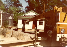
Heritage Village gets bank donation
https://search.heritageburnaby.ca/link/museumdescription18501
- Repository
- Burnaby Village Museum
- Date
- Mar. 1975
- Collection/Fonds
- Burnaby Village Museum fonds
- Description Level
- Item
- Physical Description
- 1 photograph : b&w ; 20.5 x 25.5 cm
- Scope and Content
- Photograph of President of the Century Park Museum Association John Thomson (right) standing with G.B. Langley, Vice President and B.C. General Manager of Royal Bank leaning against a sign reading "SITE FOR THE VILLAGE ROYAL BANK" on Hill Street inside Heritage Village Museum. John Thomson holds a …
- Repository
- Burnaby Village Museum
- Collection/Fonds
- Burnaby Village Museum fonds
- Series
- Royal Bank exhibit series
- Description Level
- Item
- Physical Description
- 1 photograph : b&w ; 20.5 x 25.5 cm
- Scope and Content
- Photograph of President of the Century Park Museum Association John Thomson (right) standing with G.B. Langley, Vice President and B.C. General Manager of Royal Bank leaning against a sign reading "SITE FOR THE VILLAGE ROYAL BANK" on Hill Street inside Heritage Village Museum. John Thomson holds a cheque for $15,000 in the brim of his hat from G.B. Langley to assist with the start of the second phase of Heritage Village which is to include the turn of the century Royal Bank building complete with artifacts to be moved from the site of Britannia Beach. Photograph appeared in The Columbian newspaper on March 1, 1975.
- Accession Code
- BV022.1.14
- Access Restriction
- No restrictions
- Reproduction Restriction
- May be restricted by third party rights
- Date
- Mar. 1975
- Media Type
- Photograph
- Scan Resolution
- 600
- Scan Date
- 2022-03-23
- Photographer
- Croton Studio Limited
- Notes
- Title based on contents of photograph
- Title of photograph and description information taken from newspaper article and photograph caption from The Columbian newspaper March 1, 1975 "Village Gets Bank Donation"
- Stamp on verso of photograph reads: "Croton / STUDIOS / LTD. / MIDDLEGATE SHOPPING CENTRE / 406-7155 KINGSWAY / BURNABY 1, B.C. / TELEPHONE 522-2848 / FILE NUMBER 9029 (file number filled in blue ink) / NEGATIVE NUMBER 2" (negative number filled in blue ink)
Images

![Love barn in winter, [between 1930 and 1940] (date of original), copied 1998 thumbnail](/media/hpo/_Data/_BVM_Images/2018/2018_0041_0180_001.jpg?width=280)
Love barn in winter
https://search.heritageburnaby.ca/link/museumdescription9995
- Repository
- Burnaby Village Museum
- Date
- [between 1930 and 1940] (date of original), copied 1998
- Collection/Fonds
- Burnaby Village Museum fonds
- Description Level
- Item
- Physical Description
- 1 photograph : b&w negative ; 35 mm
- Scope and Content
- Photograph of the Love barn surrounded by a large snow banks with trees and a weather vane popping out of it .The corner of the Love farmhouse back porch is on the right. In 1928 after Sarah Parker's father, Jesse Love died, William and Sarah (nee Love) Parker purchased the Love farmhouse located a…
- Repository
- Burnaby Village Museum
- Collection/Fonds
- Burnaby Village Museum fonds
- Series
- Jesse Love farmhouse series
- Subseries
- Love family photographs subseries
- Description Level
- Item
- Physical Description
- 1 photograph : b&w negative ; 35 mm
- Scope and Content
- Photograph of the Love barn surrounded by a large snow banks with trees and a weather vane popping out of it .The corner of the Love farmhouse back porch is on the right. In 1928 after Sarah Parker's father, Jesse Love died, William and Sarah (nee Love) Parker purchased the Love farmhouse located at 1390 Cumberland Road. They lived there until 1961, with their three children; Albert, Bill and Elsie. Jesse and Martha Love were the orignal owners of the house where they raised eleven children.
- Subjects
- Natural Phenomena - Snow
- Geographic Access
- Cumberland Street
- Street Address
- 7651 Cumberland Street
- Accession Code
- BV018.41.180
- Access Restriction
- No restrictions
- Reproduction Restriction
- May be restricted by third party rights
- Date
- [between 1930 and 1940] (date of original), copied 1998
- Media Type
- Photograph
- Historic Neighbourhood
- East Burnaby (Historic Neighbourhood)
- Planning Study Area
- Cariboo-Armstrong Area
- Scan Resolution
- 2400
- Scan Date
- 4-Mar-2019
- Scale
- 100
- Photographer
- Parker, Albert "Bert"
- Notes
- Title based on contents of photograph
- 1 b&w copy print accompanying
Images
![Love barn in winter, [between 1930 and 1940] (date of original), copied 1998 thumbnail](/media/hpo/_Data/_BVM_Images/2018/2018_0041_0180_001.jpg)
![Love farmhouse in winter, [between 1930 and 1940] (date of original), copied 1998 thumbnail](/media/hpo/_Data/_BVM_Images/2018/2018_0041_0172_001.jpg?width=280)
Love farmhouse in winter
https://search.heritageburnaby.ca/link/museumdescription9987
- Repository
- Burnaby Village Museum
- Date
- [between 1930 and 1940] (date of original), copied 1998
- Collection/Fonds
- Burnaby Village Museum fonds
- Description Level
- Item
- Physical Description
- 1 photograph : b&w negative ; 35 mm
- Scope and Content
- Photograph of the front of the Love farmhouse surrounded by snow with icicles hanging from the front porch and snow on the rooftops. There is a wire fence with a gate in front of the house. In 1928 after Sarah Parker's father, Jesse Love died, William and Sarah (nee Love) Parker purchased the Love …
- Repository
- Burnaby Village Museum
- Collection/Fonds
- Burnaby Village Museum fonds
- Series
- Jesse Love farmhouse series
- Subseries
- Love family photographs subseries
- Description Level
- Item
- Physical Description
- 1 photograph : b&w negative ; 35 mm
- Scope and Content
- Photograph of the front of the Love farmhouse surrounded by snow with icicles hanging from the front porch and snow on the rooftops. There is a wire fence with a gate in front of the house. In 1928 after Sarah Parker's father, Jesse Love died, William and Sarah (nee Love) Parker purchased the Love farmhouse located at 1390 Cumberland Road. They lived there until 1961, with their three children; Albert, Bill and Elsie. Jesse and Martha Love were the orignal owners of the house where they raised eleven children.
- Subjects
- Natural Phenomena - Snow
- Geographic Access
- Cumberland Street
- Street Address
- 7651 Cumberland Street
- Accession Code
- BV018.41.172
- Access Restriction
- No restrictions
- Reproduction Restriction
- May be restricted by third party rights
- Date
- [between 1930 and 1940] (date of original), copied 1998
- Media Type
- Photograph
- Historic Neighbourhood
- East Burnaby (Historic Neighbourhood)
- Planning Study Area
- Cariboo-Armstrong Area
- Scan Resolution
- 2400
- Scan Date
- 4-Mar-2019
- Scale
- 100
- Photographer
- Parker, Albert "Bert"
- Notes
- Title based on contents of photograph
- See BV988.33.34 for description of artifact
- 1 b&w copy print accompanying
Images
![Love farmhouse in winter, [between 1930 and 1940] (date of original), copied 1998 thumbnail](/media/hpo/_Data/_BVM_Images/2018/2018_0041_0172_001.jpg)
![Love farmhouse in winter, [between 1930 and 1940] (date of original), copied 1998 thumbnail](/media/hpo/_Data/_BVM_Images/2018/2018_0041_0179_001.jpg?width=280)
Love farmhouse in winter
https://search.heritageburnaby.ca/link/museumdescription9994
- Repository
- Burnaby Village Museum
- Date
- [between 1930 and 1940] (date of original), copied 1998
- Collection/Fonds
- Burnaby Village Museum fonds
- Description Level
- Item
- Physical Description
- 1 photograph : b&w negative ; 35 mm
- Scope and Content
- Photograph of the rear of the Love farmhouse surrounded by a large snow bank. There are icicles hanging from the rooftop of the main house and kitchen porch. In 1928 after Sarah Parker's father, Jesse Love died, William and Sarah (nee Love) Parker purchased the Love farmhouse located at 1390 Cumbe…
- Repository
- Burnaby Village Museum
- Collection/Fonds
- Burnaby Village Museum fonds
- Series
- Jesse Love farmhouse series
- Subseries
- Love family photographs subseries
- Description Level
- Item
- Physical Description
- 1 photograph : b&w negative ; 35 mm
- Scope and Content
- Photograph of the rear of the Love farmhouse surrounded by a large snow bank. There are icicles hanging from the rooftop of the main house and kitchen porch. In 1928 after Sarah Parker's father, Jesse Love died, William and Sarah (nee Love) Parker purchased the Love farmhouse located at 1390 Cumberland Road. They lived there until 1961, with their three children; Albert, Bill and Elsie. Jesse and Martha Love were the orignal owners of the house where they raised eleven children.
- Subjects
- Natural Phenomena - Snow
- Geographic Access
- Cumberland Street
- Street Address
- 7651 Cumberland Street
- Accession Code
- BV018.41.179
- Access Restriction
- No restrictions
- Reproduction Restriction
- May be restricted by third party rights
- Date
- [between 1930 and 1940] (date of original), copied 1998
- Media Type
- Photograph
- Historic Neighbourhood
- East Burnaby (Historic Neighbourhood)
- Planning Study Area
- Cariboo-Armstrong Area
- Scan Resolution
- 2400
- Scan Date
- 4-Mar-2019
- Scale
- 100
- Photographer
- Parker, Albert "Bert"
- Notes
- Title based on contents of photograph
- 1 b&w copy print accompanying
Images
![Love farmhouse in winter, [between 1930 and 1940] (date of original), copied 1998 thumbnail](/media/hpo/_Data/_BVM_Images/2018/2018_0041_0179_001.jpg)