Narrow Results By
Decade
- 2020s 153
- 2010s 212
- 2000s 242
- 1990s 654
- 1980s 613
- 1970s
- 1960s 314
- 1950s 395
- 1940s 582
- 1930s 548
- 1920s 481
- 1910s 482
- 1900s 408
- 1890s 117
- 1880s 26
- 1870s 14
- 1860s
- 1850s 5
- 1840s 3
- 1830s 3
- 1820s 3
- 1810s 3
- 1800s 3
- 1790s 3
- 1780s 3
- 1770s 3
- 1760s 3
- 1750s 3
- 1740s 3
- 1730s 3
- 1720s 3
- 1710s 3
- 1700s 3
- 1690s 3
- 1680s 3
- 1670s 3
- 1660s 3
- 1650s 3
- 1640s 3
- 1630s 3
- 1620s 3
- 1610s 3
- 1600s 3
- 1520s 1
Creator
- Arno, Stephen F. 1
- Baresh, Marta 1
- Bateman, Caroline Mary Wettenhall 1
- Bergson, George 1
- Binks, James 7
- British Columbia Department of Education 1
- Brown, Cice Chandler 1
- Brown, Donald N. "Don" 1
- Burnaby Art Gallery 1
- Burnaby Centennial '71 Committee 1
- Burnaby Historical Society 1
- Burnaby Village Museum 62
![Student Council at Chaffey-Burke School, [1977-1978] thumbnail](/media/hpo/_Data/_BVM_Images/2007/2007_0026_0033_001.jpg?width=280)
Student Council at Chaffey-Burke School
https://search.heritageburnaby.ca/link/museumdescription2852
- Repository
- Burnaby Village Museum
- Date
- [1977-1978]
- Collection/Fonds
- Burnaby Village Museum Photograph collection
- Description Level
- Item
- Scope and Content
- Photograph: Chaffey-Burke School student council photograph for the 1977 to 1978 school year.
- Repository
- Burnaby Village Museum
- Collection/Fonds
- Burnaby Village Museum Photograph collection
- Description Level
- Item
- Scope and Content
- Photograph: Chaffey-Burke School student council photograph for the 1977 to 1978 school year.
- Accession Code
- BV007.26.33
- Access Restriction
- Restricted access
- Reproduction Restriction
- May be restricted by third party rights
- Date
- [1977-1978]
- Media Type
- Photograph
- Scan Resolution
- 300
- Scan Date
- 29-Nov-2018
- Scale
- 96
Images
![Student Council at Chaffey-Burke School, [1977-1978] thumbnail](/media/hpo/_Data/_BVM_Images/2007/2007_0026_0033_001.jpg)
![Sui Ha Hong ploughing fields at Hop-On Farm, [between 1975 and 1979] (date of original), copied 2017 thumbnail](/media/hpo/_Data/_BVM_Images/2017/2017_0036_0010_001.jpg?width=280)
Sui Ha Hong ploughing fields at Hop-On Farm
https://search.heritageburnaby.ca/link/museumdescription4259
- Repository
- Burnaby Village Museum
- Date
- [between 1975 and 1979] (date of original), copied 2017
- Collection/Fonds
- Burnaby Village Museum Photograph collection
- Description Level
- Item
- Physical Description
- 1 photograph : colour : copy scan
- Scope and Content
- Photograph of Sui Ha Hong on a red tractor, ploughing fields at Hop-On Farm. Sui Ha is wearing a hat and apron. Farmland and trees evident in background.
- Repository
- Burnaby Village Museum
- Collection/Fonds
- Burnaby Village Museum Photograph collection
- Description Level
- Item
- Physical Description
- 1 photograph : colour : copy scan
- Scope and Content
- Photograph of Sui Ha Hong on a red tractor, ploughing fields at Hop-On Farm. Sui Ha is wearing a hat and apron. Farmland and trees evident in background.
- History
- Josephine Hong was born to Sui Ha Hong and Chan Kow Hong. The Hong Family had seven children, oldest to youngest: Pauline, Josephine, Catherine, Norine, Gary, Darlene, and Marlene. The family runs Hop-On Farm on Marine Drive in Burnaby. Many Hong family members worked on the farm including Josephine Hong's grandfather, Gay Tim Hong, and uncles. Her great-grandfather was Sui Wing Hong
- Subjects
- Persons - Chinese Canadians
- Names
- Hop On Farms
- Hong, Sui Ha
- Geographic Access
- Byrne Road
- Accession Code
- BV017.36.10
- Access Restriction
- No restrictions
- Reproduction Restriction
- May be restricted by third party rights
- Date
- [between 1975 and 1979] (date of original), copied 2017
- Media Type
- Photograph
- Historic Neighbourhood
- Fraser Arm (Historic Neighbourhood)
- Related Material
- See Oral History Interview-BV020.6.1
- Scan Resolution
- 800
- Scan Date
- 12/3/2017
- Scale
- 100
- Notes
- Title based on contents of photograph.
Images
![Sui Ha Hong ploughing fields at Hop-On Farm, [between 1975 and 1979] (date of original), copied 2017 thumbnail](/media/hpo/_Data/_BVM_Images/2017/2017_0036_0010_001.jpg)
![Sui Ha Hong seeding fields at Hop-On Farm, [between 1975 and 1979] (date of original), copied 2017 thumbnail](/media/hpo/_Data/_BVM_Images/2017/2017_0036_0014_001.jpg?width=280)
Sui Ha Hong seeding fields at Hop-On Farm
https://search.heritageburnaby.ca/link/museumdescription4263
- Repository
- Burnaby Village Museum
- Date
- [between 1975 and 1979] (date of original), copied 2017
- Collection/Fonds
- Burnaby Village Museum Photograph collection
- Description Level
- Item
- Physical Description
- 1 photograph : colour : copy scan
- Scope and Content
- Photograph of Sui Ha Hong holding plow, seeding fields at Hop-On Farm. Wooden crates, a building and a man in background. Sui Ha Hong is wearing an apron and farm boots.
- Repository
- Burnaby Village Museum
- Collection/Fonds
- Burnaby Village Museum Photograph collection
- Description Level
- Item
- Physical Description
- 1 photograph : colour : copy scan
- Scope and Content
- Photograph of Sui Ha Hong holding plow, seeding fields at Hop-On Farm. Wooden crates, a building and a man in background. Sui Ha Hong is wearing an apron and farm boots.
- History
- Josephine Hong was born to Sui Ha Hong and Chan Kow Hong. The Hong Family had seven children, oldest to youngest: Pauline, Josephine, Catherine, Norine, Gary, Darlene, and Marlene. The family runs Hop-On Farm on Marine Drive in Burnaby. Many Hong family members worked on the farm including Josephine Hong's grandfather, Gay Tim Hong, and uncles. Her great-grandfather was Sui Wing Hong
- Subjects
- Persons - Chinese Canadians
- Names
- Hop On Farms
- Hong, Sui Ha
- Geographic Access
- Byrne Road
- Accession Code
- BV017.36.14
- Access Restriction
- No restrictions
- Reproduction Restriction
- May be restricted by third party rights
- Date
- [between 1975 and 1979] (date of original), copied 2017
- Media Type
- Photograph
- Historic Neighbourhood
- Fraser Arm (Historic Neighbourhood)
- Related Material
- See Oral History Interview-BV020.6.1
- Scan Resolution
- 800
- Scan Date
- 12/3/2017
- Scale
- 100
- Notes
- Title based on contents of photograph.
Images
![Sui Ha Hong seeding fields at Hop-On Farm, [between 1975 and 1979] (date of original), copied 2017 thumbnail](/media/hpo/_Data/_BVM_Images/2017/2017_0036_0014_001.jpg)
![Survey and Subdivision plans in New Westminster District Group 1 – Burnaby
, [1861]-[1910] thumbnail](/media/hpo/_Data/_BVM_Cartographic_Material/1977/1977_0093_0019a_001.jpg?width=280)
Survey and Subdivision plans in New Westminster District Group 1 – Burnaby
https://search.heritageburnaby.ca/link/museumdescription6988
- Repository
- Burnaby Village Museum
- Date
- [1861]-[1910]
- Collection/Fonds
- Burnaby Village Museum Map collection
- Description Level
- File
- Physical Description
- 14 plans : 3 plans : black ink on paper hand col. + 7 plans : black ink on paper + 4 plans : graphite on paper mounted on 2 sides of cardboard 76 x 102 cm
- Scope and Content
- Item consists of a large board of four New Westminster District Gp 1 - subdivision plans mounted on one side and ten New Westminster District Gp 1 - subdivision plans mounted on the other side. Side A: 1. "Plan /of / Lots 166A, 166 and 167 /, Gr.1, N.W.D. / Showing Misconstructed Roads in Gree…
- Repository
- Burnaby Village Museum
- Collection/Fonds
- Burnaby Village Museum Map collection
- Description Level
- File
- Physical Description
- 14 plans : 3 plans : black ink on paper hand col. + 7 plans : black ink on paper + 4 plans : graphite on paper mounted on 2 sides of cardboard 76 x 102 cm
- Material Details
- Scales [between 1:2376 and 1:7920]
- Index number on edge of board reads: "19"
- Scope and Content
- Item consists of a large board of four New Westminster District Gp 1 - subdivision plans mounted on one side and ten New Westminster District Gp 1 - subdivision plans mounted on the other side. Side A: 1. "Plan /of / Lots 166A, 166 and 167 /, Gr.1, N.W.D. / Showing Misconstructed Roads in Green / 5 chs = 1 in.". (plan is drawn in black ink and hand coloured in red, green and orange ink). A section in the centre of the plan is coloured in red ink and identified as "C.S. Richmond" running from the North Arm of Fraser River to Wiggins Road and divided by "New Wiggins Rd. (as gazetted)" (coloured in orange ink) and two"Constructed Road(s)" (coloured in green ink). Plan is initialed by: "RB" [sic] (in blue pencil crayon) 2. Plan of / Subdivision of / Lot 166 / Group One / New Westminster District / Scale 4 chs = 1 in. / Map No 524". Plan is drawn in graphite and signed by "Surrig [sic] Welhams [sic] / P.L.S." Plan is initialed by: "RB" [sic] (in blue pencil crayon) 3. Plan of "Survey / of Highway / For / Burnaby Council / in / Lots 13 _14 / Group One / Scale 4 chs = 1 in." Signed by "Albert J. Hill, P.L.S." Caribou Street and Caribou Road run through the centre of the plan. Plan is stamped: "Albert J. Hill, Civil Engineer / and / Provincial Land Surveyor, / New Westminster, / B.C.". Plan is initialed by: "RB" [sic] (in blue pencil crayon) 4. A Plan of Lots 166A, 166 and 167, Group One, New Westminster District (drawn in graphite). A section in the centre of the plan is identified as "C.S. Richmond" running from the North Arm of Fraser River and divided by "New Wiggins Rd. (as gazetted)" and two "Constructed Road(s)". Plan is initialed by: "RB" [sic] (in blue pencil crayon) Side B: 1. Small plan drawn in black ink (no title) identifying lots north of the "North Arm" of the Fraser River. Lots identified include: Lot 99, Lot 98, Lot 157, Lot 158, Lot 163, Lot 162, Lot 159, Lot 163, Lot 162, Lot 165, Lot 166A, Lot 155B, Lot 155A and Lot 159. "Scale 40 chains to one inch" . Plan is initialed by: "RB" [sic] (in blue pencil crayon) (Geographic location: Burnaby) 2. Small plan drawn in black ink (no title) identifying lots north of the North Arm of the Fraser River as "Lots 155, 155A, 155B, 155C, 162, 163, 164, 165, 166A and 167". Plan is initialed by: "RB" [sic] (in blue pencil crayon) (Geographic location: Burnaby) 3. Small plan drawn in black ink (no title) which identifies "Lot 151 / Reserve/ for / Race Course"; "Reserve / 64 A / L. 152 G.1"; and other Lots: 32, 33, 34, 35, 36, 38, 39. The plan is signed "Surveyor G.Turn [sic] July / 61 / from Vol 40 R.L. notes [sic]" Plan is stamped: "Albert J. Hill, Civil Engineer / and / Provincial Land Surveyor, / New Westminster, / B.C." Plan is initialed by: "RB" [sic] (in blue pencil crayon) (Geographic location: Burnaby) 4. Small plan drawn in black in with faded red colouring on centre lot identified as "Lot 34" running north from "Vancouver Road" . Plan is stamped: "Albert J. Hill, Civil Engineer / and / Provincial Land Surveyor, / New Westminster, / B.C." Plan is initialed by: "RB" [sic] (in blue pencil crayon) (Geographic location: Burnaby) 5. Plan drawn in graphite and identified as "Lot 98, Gr.1," along with the intials "RB" [sic] (both are handwritten in blue crayon pencil on top of plan) The B.C.E.Railway is identified running through the plan along with Jubilee Road and Royal Oak Road. The plan is signed with the name "Wm. Murray" and the Plan is stamped: "Albert J. Hill, Civil Engineer / and / Provincial Land Surveyor, / New Westminster, / B.C.". (Geographic location: Burnaby) 6. Plan drawn in graphite identified as "Port Lot 13, Gr.1" along with the intials "RB" [sic] (both are handwritten in blue crayon pencil on top of plan) Plan is stamped: "Albert J. Hill, Civil Engineer / and / Provincial Land Surveyor, / New Westminster, / B.C.". (Geographic location: Burnaby) 7.Plan drawn in black ink and identified as "Lot 98 G.1" along with the intials "RB" [sic] (both are handwritten in blue crayon pencil on top of plan). A "Road Reservation" is identified running north between "Electric Tramway" and connecting with "Royal Oak Road". Plan is stamped: "Albert J. Hill, Civil Engineer / and / Provincial Land Surveyor, / New Westminster, / B.C." (Geographic location: Burnaby) 8. Plan drawn in black ink and divided into two sections, the upper plan is identified as "Portion / Lots 100 / area / 101, Gr.1" and the lower plan is identified as "Portion L. 3 G. 1" along with the intials "RB" [sic] (these identifiers are handwritten in blue crayon pencil on top of the plan). Portions of Lot 100 and Lot 101 are each divided into 6 sections and the Portion of Lot 3 plan is divided into 24 sections. The plan includes a note in black ink that reads: " Received from Wm Fromme [sic] / from Wm. Trapp / Nov. 28, 1895 / A. J. T...[sic]". (Geographic location: Burnaby) 9. Plan drawn in black ink (no title) identifying soil, buildings and geographic features in southern Burnaby. The plan is bordered by "New Westminster City" (Tenth Avenue and DL 172) to the south east and DL 173 to the south, DL 158 to the west and the B.C.E. Tramway to the north. Plan includes District Lots: 155A, 158, 159, 171, 160, 53 and 95 and identifies soil, marshland and ravines throughout. Plan identifies the following features: a "Team Road" running through Lots 158 and 159 along with "Fair Orchard Soil / Even Surface Throughout / No Ravines", "Gravel and Shingle" (bottom of Lot 158), "North Arm Road" crossing "Byrne Road" and connecting with "Power House Road" which runs north to connect with "Highland Park Station" and the B.C.E. Tramway, "Power Ho" in the northeast corner of DL 160, a "Brook" connected with a "Deep Ravine" running between DL 53, DL 95 and DL 160 along with "Good Soil" and "Fair Orchard Soil" identified nearby in DL 95. Scale is identified as "10 chs = 1 in." Plan is stamped: "Albert J. Hill, Civil Engineer / and / Provincial Land Surveyor, / New Westminster, / B.C." Plan is initialed by: "RB" [sic] (in blue pencil crayon) (Geographic location: Burnaby) 10. Plan drawn in black ink (no title) with Burnaby Lake and Deer Lake at the centre. The plan is bordered by the following District Lots identified as: 117, 118 and 68 to the west, Lots 80, 79 and 85 to the southwest, Lots 11, 13, and 1 (City of New Westminster) to the south east, the North Road boundary to the east and Lots 8, 56, 57, 59, and 136 to the North. The lower right hand corner of the plan has a small inset which reads: "Burnaby Lake" and "Page 19 R.B. Notes". Plan is initialed by: "RB" [sic] (in blue pencil crayon) (Geographic location: Burnaby)
- Creator
- Hill, Albert James
- Accession Code
- HV977.93.19
- Access Restriction
- No restrictions
- Reproduction Restriction
- No known restrictions
- Date
- [1861]-[1910]
- Media Type
- Cartographic Material
- Scan Resolution
- 300
- Scale
- 72
- Notes
- Title based on contents of file
- Scale is measured in chains. (One chain equals 792 inches)
- The term "Lot" can also refer to a "District Lot”
- Some plans are stamped: "Albert J. Hill, Civil Engineer / and / Provincial Land Surveyor, / New Westminster, / B.C." and intialed: "RB" [sic]
Images
![Survey and Subdivision plans in New Westminster District Group 1 – Burnaby
, [1861]-[1910] thumbnail](/media/hpo/_Data/_BVM_Cartographic_Material/1977/1977_0093_0019a_001.jpg)

![Survey and Subdivision plans in New Westminster District Group 1 – Burnaby, Port Moody, [1862-1908] thumbnail](/media/hpo/_Data/_BVM_Cartographic_Material/1977/1977_0093_0026a_001.jpg?width=280)
Survey and Subdivision plans in New Westminster District Group 1 – Burnaby, Port Moody
https://search.heritageburnaby.ca/link/museumdescription6995
- Repository
- Burnaby Village Museum
- Date
- [1862-1908]
- Collection/Fonds
- Burnaby Village Museum Map collection
- Description Level
- File
- Physical Description
- 9 plans : 6 plans : black ink on paper ; 57 x 36.5 cm or smaller + 1 plan : black ink and grahite on paper ; 46.5 x 49 cm + 1 plan : blueprint on paper ; 15.5 x 19.5 cm + cm + 1 plan : graphite on paper ; 25 x 17 cm ; mounted on both sides of board 76 x 102 cm
- Scope and Content
- Item consists of a large board of four New Westminster District subdivision plans mounted on one side and five New Westminster District subdivision plans mounted on the other side. Side A: 1. "Plan / of Subdivision / of a Portion / of / Lot 87 / Group One / New Westminster District / Scale 4 chs…
- Repository
- Burnaby Village Museum
- Collection/Fonds
- Burnaby Village Museum Map collection
- Description Level
- File
- Physical Description
- 9 plans : 6 plans : black ink on paper ; 57 x 36.5 cm or smaller + 1 plan : black ink and grahite on paper ; 46.5 x 49 cm + 1 plan : blueprint on paper ; 15.5 x 19.5 cm + cm + 1 plan : graphite on paper ; 25 x 17 cm ; mounted on both sides of board 76 x 102 cm
- Material Details
- Scales [between 1:792 and 1:3600]
- Index number on edge of board reads: "26"
- Scope and Content
- Item consists of a large board of four New Westminster District subdivision plans mounted on one side and five New Westminster District subdivision plans mounted on the other side. Side A: 1. "Plan / of Subdivision / of a Portion / of / Lot 87 / Group One / New Westminster District / Scale 4 chs = 1 in". Plan is stamped: "Albert J. Hill, Civil Engineer / and / Provincial Land Surveyor, / New Westminster, / B.C." and intialed by: "RB" [sic] (in blue pencil crayon). Names two of the subdivisons of District Lot 87 are identified as, "L.E. Sprott" and "John Ledger". (Geographic location: Burnaby) 2. "Plan of Subdivision / of / Portions of / Lot 136, 131 and Lots 44 and 78 Gr.1 / New Westminster District / Scale 300 ft = 1 inch". Annotation above title reads: "No. 901 / Deposited in Land Registry Office / New Westminster / Aug. 19th 1905 / Charles S. Keith D. Reg." Annotations and signatures at bottom of plan read: "I, William Nelson Draper, / W.H.R. Collister / Charles E. Perkins / E.B. Morgan / make / Surveys / correct / representation / upon / the / Land Registry Act / (sgd) W.N. Draper, P.L.S.". Plan includes a handwritten title: "Lots 136, 131, 44 & 78" and is initialed: "RB" [sic] (in blue pencil crayon) (Geographic location: Burnaby) 3. "Survey / of / a Portion / of / Lot 95, Gr.1 / Scale 1 ch = 1in." Plan is stamped: "Albert J. Hill, Civil Engineer / and / Provincial Land Surveyor, / New Westminster, / B.C." and is initialed : "RB" [sic] (in blue pencil crayon) (Geographic location: Burnaby) 4. Blueprint plan of "Lot 396. Group One." with Scale : 3 chs = 1 in. A two acre portion of District Lot 396 is filled in with red ink." Plan is signed by "Albert J. Hill / B.C.L.S." (Geographic location: Port Moody) Side B: 1. Plan titled "District Lot 92 / Burnaby / Municipality / for sale by / Mahon / McFarland & / Mahon Ltd. / Vancouver, B.C. / Scale : 4 chains to one inch". District Lot 92 is subdivided into 161 lots and identifies roads: Norwich Road, Pole Line Road, Oakland Road, Stanley Road, Burford Road, Dalhousie Road, Brantford Road, Colborne Road, Roberts Road, Vancouver & Westminster Road, B.C. Electric Railway, Gilley Stn. and Burnaby (Power House). The bottom of the plan reads: "G.S. Dawson, P.LS. Vancouver, B.C." (Geographic location: Burnaby) 2. "Plan / of Subdivision / of a Portion / of / Lot 29 / Group 1 / New Westminster District / Scale 2 chs = 1 in". Plan is stamped: "Albert J. Hill, Civil Engineer / and / Provincial Land Surveyor, / New Westminster, / B.C." and is initialed by: "RB" [sic] (in blue pencil crayon) (Geographic location: Burnaby) 3. Small handrawn plan (no title) identifying "Lot 84 / Hydes, Claim" at the centre surrounded by lots and features identified as: "Lot 85", "Lot 93", "Lot 94", "Lot 32", "Lot 82", "Lot 83", "Lot 79", "swamp" and a "Small Lake" (Burnaby Lake). Identifying marks in the right corner of the plan read: "Page 13 / Surveyed by G. Turner / May 62". Plan also includes surveyor's bearing measurements and trails to "Small Lake" (Burnaby Lake). (Geographic location: Burnaby) 4. Untitled plan showing District Lots west of North Road and north of Burnaby Lake including: Lots 2, 4, 6, 8, 15, 10, 56, 148, 57, 58, 40. and Lots 3, 5, 7 east of North Road (Coquitlam). Lots in Burnaby are identifed for timber including: "Heavily Timbered" (Lot 57), " "Some Fir and Cedar" (Lot 40), "Splendid Fir and Cedar" (Lot 143), "Heavy Fir etc" (Lots 143 and 148), " "Fine Cedar" (Lot 15), "Rough Light Timber" (Lot 56). Other features identified at the lower portion of the plan include "Burnaby Lake" and "Brunette River". (Geographic location: Burnaby) 5. Untitled plan drawn in graphite showing sections of District Lot 85 south of Burnaby Lake and north of Hazsard Road. Plan is signed: "Albert J. Hill / B.C.L.S." and dated "12/26/08". Plan is initialed by: "RB" [sic] (in blue pencil crayon) (Geographic location: Burnaby)
- Publisher
- Mahon, McFarland & Mahon Ltd
- Accession Code
- HV977.93.26
- Access Restriction
- No restrictions
- Reproduction Restriction
- No known restrictions
- Date
- [1862-1908]
- Media Type
- Cartographic Material
- Historic Neighbourhood
- Burnaby Lake (Historic Neighbourhood)
- Burquitlam (Historic Neighbourhood)
- Planning Study Area
- Burnaby Lake Area
- Scan Resolution
- 300
- Scale
- 72
- Notes
- Title based on contents of file
- Scale is measured in chains and feet. (One chain equals 792 inches)
- The term "Lot" can also refer to a "District Lot”
Images
![Survey and Subdivision plans in New Westminster District Group 1 – Burnaby, Port Moody, [1862-1908] thumbnail](/media/hpo/_Data/_BVM_Cartographic_Material/1977/1977_0093_0026a_001.jpg)


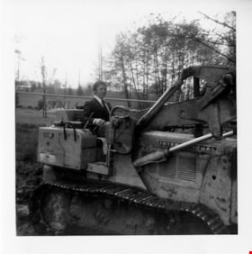
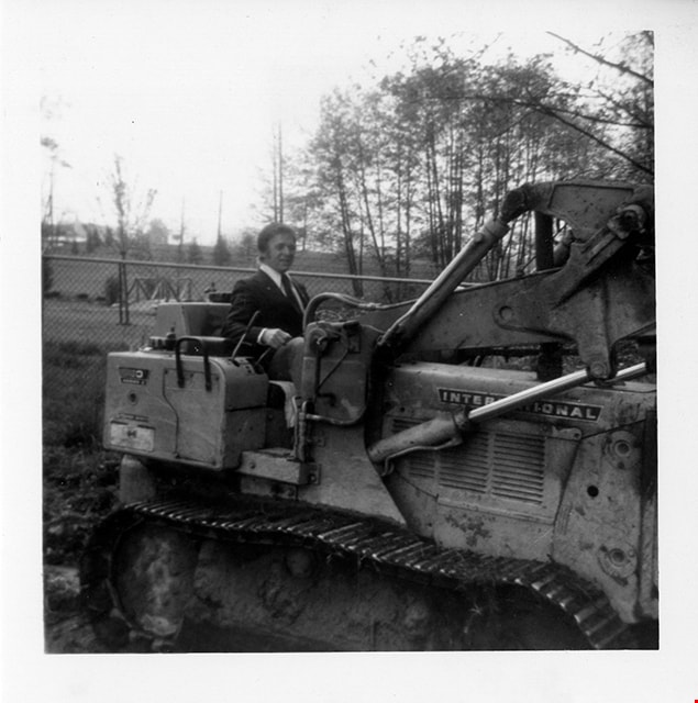
Tom Constable operating caterpillar at Heritage Village sod turning
https://search.heritageburnaby.ca/link/museumdescription3556
- Repository
- Burnaby Village Museum
- Date
- 11 April 1971
- Collection/Fonds
- Donald Copan collection
- Description Level
- Item
- Physical Description
- 1 photograph : b&w ; 8.9 x 8.9 cm
- Scope and Content
- Photograph of Tom Constable operating a tractor at the Ground Breaking Ceremony for the Heritage Village (now Burnaby Village Museum) on April 11, 1971.
- Repository
- Burnaby Village Museum
- Collection/Fonds
- Donald Copan collection
- Series
- Copan album series
- Description Level
- Item
- Physical Description
- 1 photograph : b&w ; 8.9 x 8.9 cm
- Scope and Content
- Photograph of Tom Constable operating a tractor at the Ground Breaking Ceremony for the Heritage Village (now Burnaby Village Museum) on April 11, 1971.
- Accession Code
- BV005.54.6
- Access Restriction
- No restrictions
- Reproduction Restriction
- May be restricted by third party rights
- Date
- 11 April 1971
- Media Type
- Photograph
- Historic Neighbourhood
- Burnaby Lake (Historic Neighbourhood)
- Planning Study Area
- Morley-Buckingham Area
- Scan Resolution
- 600
- Scan Date
- July 16, 2020
- Scale
- 100
- Notes
- Title based on contents of photograph
Images
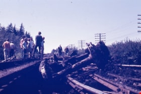
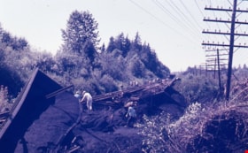
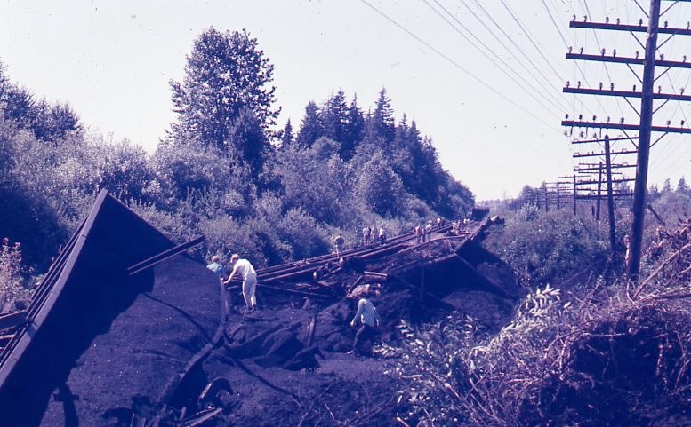
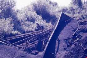
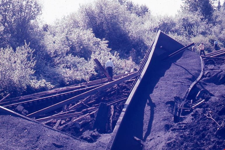
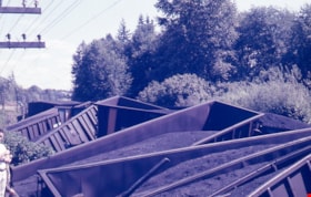
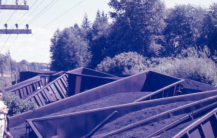
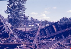
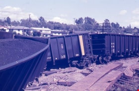
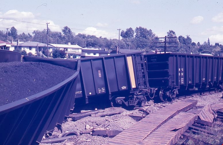
Train wreck at Kensington Avenue
https://search.heritageburnaby.ca/link/museumdescription4306
- Repository
- Burnaby Village Museum
- Date
- 16 Aug. 1970
- Collection/Fonds
- Burnaby Village Museum Photograph collection
- Description Level
- Item
- Physical Description
- 1 photograph : col. ; 35 mm
- Scope and Content
- Photograph of a train wreck at Kensington Avenue and the Lougheed Highway on Aug 16, 1970. The Farmer family was living at Buchanan Street and Holdom Avenue and they heard the train wreck when it happened.
- Repository
- Burnaby Village Museum
- Collection/Fonds
- Burnaby Village Museum Photograph collection
- Description Level
- Item
- Physical Description
- 1 photograph : col. ; 35 mm
- Material Details
- The slide was processed in Canachrome by Mortifee Munshaw.
- Handwritten text in ink on slide frame reads: "Train Wreck / Aug 16 /70".
- Scope and Content
- Photograph of a train wreck at Kensington Avenue and the Lougheed Highway on Aug 16, 1970. The Farmer family was living at Buchanan Street and Holdom Avenue and they heard the train wreck when it happened.
- Names
- Farmer, Joanne
- Geographic Access
- Kensington Avenue
- Lougheed Highway
- Accession Code
- BV017.42.1
- Access Restriction
- No restrictions
- Reproduction Restriction
- No known restrictions
- Date
- 16 Aug. 1970
- Media Type
- Photograph
- Planning Study Area
- Brentwood Area
- Scan Resolution
- 600
- Scan Date
- 05-Jun-2018
- Notes
- Title based on contents of photograph
Images

Train wreck at Kensington Avenue
https://search.heritageburnaby.ca/link/museumdescription4307
- Repository
- Burnaby Village Museum
- Date
- 16 Aug. 1970
- Collection/Fonds
- Burnaby Village Museum Photograph collection
- Description Level
- Item
- Physical Description
- 1 photograph : col. ; 35 mm
- Scope and Content
- Photograph of a train wreck at Kensington Avenue and the Lougheed Highway on Aug 16, 1970. The Farmer family was living at Buchanan Street and Holdom Avenue and they heard the train wreck when it happened.
- Repository
- Burnaby Village Museum
- Collection/Fonds
- Burnaby Village Museum Photograph collection
- Description Level
- Item
- Physical Description
- 1 photograph : col. ; 35 mm
- Material Details
- The slide was processed in Canachrome by Mortifee Munshaw.
- Handwritten text in ink on slide frame reads: "Train Wreck / Aug 16 /70".
- Scope and Content
- Photograph of a train wreck at Kensington Avenue and the Lougheed Highway on Aug 16, 1970. The Farmer family was living at Buchanan Street and Holdom Avenue and they heard the train wreck when it happened.
- Names
- Farmer, Joanne
- Geographic Access
- Kensington Avenue
- Lougheed Highway
- Accession Code
- BV017.42.2
- Access Restriction
- No restrictions
- Reproduction Restriction
- No known restrictions
- Date
- 16 Aug. 1970
- Media Type
- Photograph
- Planning Study Area
- Brentwood Area
- Scan Resolution
- 600
- Scan Date
- 05-Jun-2018
- Notes
- Title based on contents of photograph
Images
Train wreck at Kensington Avenue
https://search.heritageburnaby.ca/link/museumdescription4308
- Repository
- Burnaby Village Museum
- Date
- 16 Aug. 1970
- Collection/Fonds
- Burnaby Village Museum Photograph collection
- Description Level
- Item
- Physical Description
- 1 photograph : col. ; 35 mm
- Scope and Content
- Photograph of a train wreck at Kensington Avenue and the Lougheed Highway on Aug 16, 1970. The Farmer family was living at Buchanan Street and Holdom Avenue and they heard the train wreck when it happened.
- Repository
- Burnaby Village Museum
- Collection/Fonds
- Burnaby Village Museum Photograph collection
- Description Level
- Item
- Physical Description
- 1 photograph : col. ; 35 mm
- Material Details
- The slide was processed in Canachrome by Mortifee Munshaw.
- Handwritten text in ink on slide frame reads: "Train Wreck / Aug 16 /70 / Lougheed Hiway".
- Scope and Content
- Photograph of a train wreck at Kensington Avenue and the Lougheed Highway on Aug 16, 1970. The Farmer family was living at Buchanan Street and Holdom Avenue and they heard the train wreck when it happened.
- Names
- Farmer, Joanne
- Geographic Access
- Kensington Avenue
- Lougheed Highway
- Accession Code
- BV017.42.3
- Access Restriction
- No restrictions
- Reproduction Restriction
- No known restrictions
- Date
- 16 Aug. 1970
- Media Type
- Photograph
- Planning Study Area
- Brentwood Area
- Scan Resolution
- 600
- Scan Date
- 05-Jun-2018
- Notes
- Title based on contents of photograph
Images
Train wreck at Kensington Avenue
https://search.heritageburnaby.ca/link/museumdescription4309
- Repository
- Burnaby Village Museum
- Date
- 16 Aug. 1970
- Collection/Fonds
- Burnaby Village Museum Photograph collection
- Description Level
- Item
- Physical Description
- 1 photograph : col. ; 35 mm
- Scope and Content
- Photograph of a train wreck at Kensington Avenue and the Lougheed Highway on Aug 16, 1970. The Farmer family was living at Buchanan Street and Holdom Avenue and they heard the train wreck when it happened.
- Repository
- Burnaby Village Museum
- Collection/Fonds
- Burnaby Village Museum Photograph collection
- Description Level
- Item
- Physical Description
- 1 photograph : col. ; 35 mm
- Material Details
- The slide was processed in Canachrome by Mortifee Munshaw.
- Handwritten text in ink on slide frame reads: "Train Wreck / Aug 16 /70".
- Scope and Content
- Photograph of a train wreck at Kensington Avenue and the Lougheed Highway on Aug 16, 1970. The Farmer family was living at Buchanan Street and Holdom Avenue and they heard the train wreck when it happened.
- Names
- Farmer, Joanne
- Geographic Access
- Kensington Avenue
- Lougheed Highway
- Accession Code
- BV017.42.4
- Access Restriction
- No restrictions
- Reproduction Restriction
- No known restrictions
- Date
- 16 Aug. 1970
- Media Type
- Photograph
- Planning Study Area
- Brentwood Area
- Scan Resolution
- 600
- Scan Date
- 05-Jun-2018
- Notes
- Title based on contents of photograph
Images
Train wreck at Kensington Avenue
https://search.heritageburnaby.ca/link/museumdescription4310
- Repository
- Burnaby Village Museum
- Date
- 16 Aug. 1970
- Collection/Fonds
- Burnaby Village Museum Photograph collection
- Description Level
- Item
- Physical Description
- 1 photograph : col. ; 35 mm
- Scope and Content
- Photograph of a train wreck at Kensington Avenue and the Lougheed Highway on Aug 16, 1970. The Farmer family was living at Buchanan Street and Holdom Avenue and they heard the train wreck when it happened.
- Repository
- Burnaby Village Museum
- Collection/Fonds
- Burnaby Village Museum Photograph collection
- Description Level
- Item
- Physical Description
- 1 photograph : col. ; 35 mm
- Material Details
- The slide was processed in Canachrome by Mortifee Munshaw.
- Handwritten text in ink on slide frame reads: "Train Wreck / Aug 16 /70".
- Scope and Content
- Photograph of a train wreck at Kensington Avenue and the Lougheed Highway on Aug 16, 1970. The Farmer family was living at Buchanan Street and Holdom Avenue and they heard the train wreck when it happened.
- Names
- Farmer, Joanne
- Geographic Access
- Kensington Avenue
- Lougheed Highway
- Accession Code
- BV017.42.5
- Access Restriction
- No restrictions
- Reproduction Restriction
- No known restrictions
- Date
- 16 Aug. 1970
- Media Type
- Photograph
- Planning Study Area
- Brentwood Area
- Scan Resolution
- 600
- Scan Date
- 05-Jun-2018
- Notes
- Title based on contents of photograph
Images

Train wreck at Kensington Avenue
https://search.heritageburnaby.ca/link/museumdescription4311
- Repository
- Burnaby Village Museum
- Date
- 16 Aug. 1970
- Collection/Fonds
- Burnaby Village Museum Photograph collection
- Description Level
- Item
- Physical Description
- 1 photograph : col. ; 35 mm
- Scope and Content
- Photograph of a train wreck at Kensington Avenue and the Lougheed Highway on Aug 16, 1970. The Farmer family was living at Buchanan Street and Holdom Avenue and they heard the train wreck when it happened.
- Repository
- Burnaby Village Museum
- Collection/Fonds
- Burnaby Village Museum Photograph collection
- Description Level
- Item
- Physical Description
- 1 photograph : col. ; 35 mm
- Material Details
- The slide was processed in Canachrome by Mortifee Munshaw.
- Handwritten text in ink on slide frame reads: "Train Wreck / Aug 16 /70".
- Scope and Content
- Photograph of a train wreck at Kensington Avenue and the Lougheed Highway on Aug 16, 1970. The Farmer family was living at Buchanan Street and Holdom Avenue and they heard the train wreck when it happened.
- Names
- Farmer, Joanne
- Geographic Access
- Kensington Avenue
- Lougheed Highway
- Accession Code
- BV017.42.6
- Access Restriction
- No restrictions
- Reproduction Restriction
- No known restrictions
- Date
- 16 Aug. 1970
- Media Type
- Photograph
- Planning Study Area
- Brentwood Area
- Scan Resolution
- 600
- Scan Date
- 05-Jun-2018
- Notes
- Title based on contents of photograph
Images
![Tram car at Heritage Village, [1971] thumbnail](/media/hpo/_Data/_BVM_Images/2005/2005_0054_0429_001.jpg?width=280)
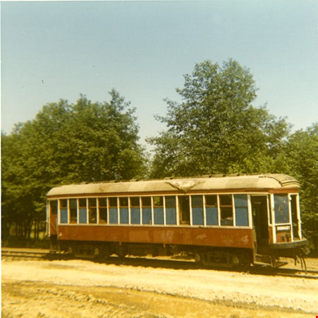
Tram car at Heritage Village
https://search.heritageburnaby.ca/link/museumdescription2383
- Repository
- Burnaby Village Museum
- Date
- [1971]
- Collection/Fonds
- Donald Copan collection
- Description Level
- Item
- Physical Description
- 1 photograph : b&w ; 8.9 x 12.7 cm
- Scope and Content
- Photograph of Interurban tram 1223 on site at Heritage Village site (now Burnaby Village Museum). The tram car was moved from Edmonds and Kingsway in 1971 where it was on display from 1958.
- Repository
- Burnaby Village Museum
- Collection/Fonds
- Donald Copan collection
- Series
- Copan album series
- Description Level
- Item
- Physical Description
- 1 photograph : b&w ; 8.9 x 12.7 cm
- Scope and Content
- Photograph of Interurban tram 1223 on site at Heritage Village site (now Burnaby Village Museum). The tram car was moved from Edmonds and Kingsway in 1971 where it was on display from 1958.
- Subjects
- Transportation - Electric Railroads
- Accession Code
- BV005.54.429
- Access Restriction
- No restrictions
- Reproduction Restriction
- May be restricted by third party rights
- Date
- [1971]
- Media Type
- Photograph
- Historic Neighbourhood
- Burnaby Lake (Historic Neighbourhood)
- Planning Study Area
- Morley-Buckingham Area
- Scan Resolution
- 600
- Scan Date
- August 11, 2020
- Scale
- 100
- Notes
- Title based on contents of photograph
Images
![Tram car at Heritage Village, [1971] thumbnail](/media/hpo/_Data/_BVM_Images/2005/2005_0054_0429_001.jpg)

Tram car on Heritage Village site
https://search.heritageburnaby.ca/link/museumdescription13347
- Repository
- Burnaby Village Museum
- Date
- 1971
- Collection/Fonds
- Donald Copan collection
- Description Level
- Item
- Physical Description
- 1 photograph : col. ; 8.9 x 8.9 cm
- Scope and Content
- Photograph of tram car on Heritage Village site (now Burnaby Village Museum). Heritage Village opened on November 19, 1971.
- Repository
- Burnaby Village Museum
- Collection/Fonds
- Donald Copan collection
- Series
- Copan album series
- Description Level
- Item
- Physical Description
- 1 photograph : col. ; 8.9 x 8.9 cm
- Scope and Content
- Photograph of tram car on Heritage Village site (now Burnaby Village Museum). Heritage Village opened on November 19, 1971.
- Subjects
- Transportation - Electric Railroads
- Accession Code
- BV005.54.366
- Access Restriction
- No restrictions
- Reproduction Restriction
- May be restricted by third party rights
- Date
- 1971
- Media Type
- Photograph
- Historic Neighbourhood
- Burnaby Lake (Historic Neighbourhood)
- Planning Study Area
- Morley-Buckingham Area
- Scan Resolution
- 600
- Scan Date
- 4-Aug-2020
- Scale
- 100
- Notes
- Title based on contents of photograph
Images
![Unidentified couple, [186-] thumbnail](/media/hpo/_Data/_BVM_Images/2000/200500590016.jpg?width=280)
Unidentified couple
https://search.heritageburnaby.ca/link/museumdescription1949
- Repository
- Burnaby Village Museum
- Date
- [186-]
- Collection/Fonds
- Burnaby Village Museum Photograph collection
- Description Level
- Item
- Physical Description
- 1 photograph : b&w tintype ; 8 x 6 cm
- Scope and Content
- Photograph of an unidentified couple taken in a photographic studio. The man is standing, wearing a three piece suit (his blazer has been left unbuttoned), with his hat held in his right hand. The woman is seated beside him, in a simple dress with a lace collar.
- Repository
- Burnaby Village Museum
- Collection/Fonds
- Burnaby Village Museum Photograph collection
- Description Level
- Item
- Physical Description
- 1 photograph : b&w tintype ; 8 x 6 cm
- Scope and Content
- Photograph of an unidentified couple taken in a photographic studio. The man is standing, wearing a three piece suit (his blazer has been left unbuttoned), with his hat held in his right hand. The woman is seated beside him, in a simple dress with a lace collar.
- Accession Code
- BV005.59.16
- Access Restriction
- No restrictions
- Reproduction Restriction
- No known restrictions
- Date
- [186-]
- Media Type
- Photograph
- Scan Resolution
- 600
- Scan Date
- 11-Jun-09
- Scale
- 100
- Notes
- Title based on contents of photograph
Images
![Unidentified couple, [186-] thumbnail](/media/hpo/_Data/_BVM_Images/2000/200500590016.jpg)
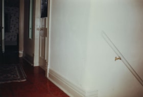
Upper floor of Love farmhouse
https://search.heritageburnaby.ca/link/museumdescription1125
- Repository
- Burnaby Village Museum
- Date
- 1971 (date of original), copied 1990
- Collection/Fonds
- Love family fonds
- Description Level
- Item
- Physical Description
- 1 photograph : col. ; 10 x 15 cm print
- Scope and Content
- Photograph of the upper hallway of the Love farmhouse while Elsie (nee Love) Hughes, her husband John and son Brent lived in the house. The house was located at 7651 Cumberland Street (Address pre 1960: 1390 Cumberland Road) and was moved from its original site to the Burnaby Village Museum in 1988…
- Repository
- Burnaby Village Museum
- Collection/Fonds
- Love family fonds
- Description Level
- Item
- Physical Description
- 1 photograph : col. ; 10 x 15 cm print
- Material Details
- Copy print was made from re-photographing an original colour slide
- Scope and Content
- Photograph of the upper hallway of the Love farmhouse while Elsie (nee Love) Hughes, her husband John and son Brent lived in the house. The house was located at 7651 Cumberland Street (Address pre 1960: 1390 Cumberland Road) and was moved from its original site to the Burnaby Village Museum in 1988 and designated a Municipal Heritage Landmark in 1992.
- Geographic Access
- Cumberland Street
- Street Address
- 7651 Cumberland Street
- Accession Code
- BV992.15.6
- Access Restriction
- Restricted access
- Reproduction Restriction
- May be restricted by third party rights
- Date
- 1971 (date of original), copied 1990
- Media Type
- Photograph
- Historic Neighbourhood
- East Burnaby (Historic Neighbourhood)
- Planning Study Area
- Cariboo-Armstrong Area
- Scan Resolution
- 600
- Scan Date
- 01-Jun-09
- Scale
- 100
- Photographer
- Parker, Albert "Bert"
- Notes
- Title based on contents of photograph
Images
![Vancouver, [before 1973] thumbnail](/media/hpo/_Data/_BVM_Images/1973/1973_0041_0008_001.jpg?width=280)
Vancouver
https://search.heritageburnaby.ca/link/museumdescription999
- Repository
- Burnaby Village Museum
- Date
- [before 1973]
- Collection/Fonds
- Burnaby Village Museum Photograph collection
- Description Level
- Item
- Physical Description
- 1 photograph : b&w ; 7.0 x 11.4 cm
- Scope and Content
- Photograph of a destination sign that reads "Vancouver" on a British Columbia Electric Railway tram. Just below the sign is a label that reads, "BCER 1231-B48."
- Repository
- Burnaby Village Museum
- Collection/Fonds
- Burnaby Village Museum Photograph collection
- Description Level
- Item
- Physical Description
- 1 photograph : b&w ; 7.0 x 11.4 cm
- Scope and Content
- Photograph of a destination sign that reads "Vancouver" on a British Columbia Electric Railway tram. Just below the sign is a label that reads, "BCER 1231-B48."
- Subjects
- Transportation - Electric Railroads
- Geographic Access
- Vancouver
- Accession Code
- HV973.41.8
- Access Restriction
- No restrictions
- Reproduction Restriction
- May be restricted by third party rights
- Date
- [before 1973]
- Media Type
- Photograph
- Related Material
- For an earlier donation made by the same donor in regards to BCER tram, see accession HV972.202.
- Scan Resolution
- 600
- Scan Date
- 2023-05-16
- Notes
- Title based on contents of photograph
Images
![Vancouver, [before 1973] thumbnail](/media/hpo/_Data/_BVM_Images/1973/1973_0041_0008_001.jpg)
![Visitors at the blacksmith shop at the Heritage Village Museum., [197_] thumbnail](/media/hpo/_Data/_BVM_Images/2018/2018_0026_0008_001.jpg?width=280)
Visitors at the blacksmith shop at the Heritage Village Museum.
https://search.heritageburnaby.ca/link/museumdescription5109
- Repository
- Burnaby Village Museum
- Date
- [197_]
- Collection/Fonds
- Burnaby Village Museum Photograph collection
- Description Level
- Item
- Physical Description
- 1 photograph : col ; copy print ; 9 cm x 9 cm
- Scope and Content
- A group of people watching a demonstration outside the blacksmith shop at the Heritage Village Museum. Multiple wagon wheels are outside the shop. A large antler is nailed above the entrance.
- Repository
- Burnaby Village Museum
- Collection/Fonds
- Burnaby Village Museum Photograph collection
- Description Level
- Item
- Physical Description
- 1 photograph : col ; copy print ; 9 cm x 9 cm
- Scope and Content
- A group of people watching a demonstration outside the blacksmith shop at the Heritage Village Museum. Multiple wagon wheels are outside the shop. A large antler is nailed above the entrance.
- Accession Code
- BV018.26.8
- Access Restriction
- No restrictions
- Date
- [197_]
- Media Type
- Photograph
- Scan Resolution
- 600
- Scan Date
- 12-Jun-18
- Notes
- Title based on contents of photograph
Images
![Visitors at the blacksmith shop at the Heritage Village Museum., [197_] thumbnail](/media/hpo/_Data/_BVM_Images/2018/2018_0026_0008_001.jpg)
William Harold Carr fonds
https://search.heritageburnaby.ca/link/museumdescription10136
- Repository
- Burnaby Village Museum
- Date
- 1977
- Collection/Fonds
- William Harold Carr fonds
- Description Level
- Fonds
- Physical Description
- 1 album (ca. 28 photographs)
- Scope and Content
- Fonds consists of a thirty three page photograph album documenting the building of an outhouse by Century Park Museum Association volunteer, Harold Carr on the site of Heritage Village in Century Park (Burnaby Village Museum). The album is titled: "THE EPIC OF THE / OUTHOUSE / The Only (Privy) Bif…
- Repository
- Burnaby Village Museum
- Collection/Fonds
- William Harold Carr fonds
- Description Level
- Fonds
- Physical Description
- 1 album (ca. 28 photographs)
- Material Details
- Pages include typewritten text pasted below each photograph
- Scope and Content
- Fonds consists of a thirty three page photograph album documenting the building of an outhouse by Century Park Museum Association volunteer, Harold Carr on the site of Heritage Village in Century Park (Burnaby Village Museum). The album is titled: "THE EPIC OF THE / OUTHOUSE / The Only (Privy) Biffy in Heritage Village with the Good Housekeeping / Seal of disApproval, 1977" / "Built by Mr. W. H. Carr / Privy Councillor / and Builder Emeritus". Photography by R. S. Banford & M. Smith, Marbo Photographics, North Vancouver."
- History
- William Harold Carr was the son of Mr. and Mrs. Joseph Carr of Vancouver. He and his twin brother, James Allen Carr, were born in Edmonton on June 18, 1917. Harold moved to Burnaby with his family (including his sisters, Muriel and Maisie) in 1924. His parents bought a lot in District Lot 94 and built a house at 3119 Royal Oak, (after 1958: 6270 Royal Oak Ave.). After World War II, Harold married Daphne Adel Withers on April 13, 1946 at Christ Church Cathedral in Vancouver. In 1946, the couple built a house at 2836 Pearl Avenue (Address after 1958: 6269 Pearl Ave.). The house was built on a portion of District Lot 94 that faced Pearl Street and was owned by Harold’s parents, Mr. and Mrs. Joseph Carr. Harold and Daphne had one child named Warren. Harold worked as an engineer for the CPR and prior to this he worked at Mohawk Lumber. Harold and his wife Daphne became involved with the Century Park Museum Association in the mid-1970s. Daphne volunteered to run the gift shop while Harold volunteered as an engineer on the model railway. Besides working on the model railway in Heritage Village, Harold also built a chicken coup and the outhouse located near Tom Irvine’s house. Harold died in 1981 at the age of 64 years, just one year prior to his retirement at CPR.
- Creator
- Carr, William Harold
- Accession Code
- BV011.59
- Access Restriction
- No restrictions
- Reproduction Restriction
- May be restricted by third party rights
- Date
- 1977
- Media Type
- Textual Record
- Photograph
- Arrangement
- Photograph album and photographs within are described at item level
- Notes
- Tilte based on contents of fonds
William J. Devitt papers
https://search.heritageburnaby.ca/link/archivedescription58429
- Repository
- City of Burnaby Archives
- Date
- 1901-1996 (date of originals)
- Collection/Fonds
- Burnaby Historical Society fonds
- Description Level
- File
- Physical Description
- 1 file of textual records
- Scope and Content
- File consists of photocopied photographs, newspaper articles and correspondence pertaining to William J. "Bill" Devitt, who served as Burnaby Police Chief from 1921 to 1936. These pages were compiled by the Burnaby Village Museum when researching information for the writers of "Follow that Fire."
- Repository
- City of Burnaby Archives
- Date
- 1901-1996 (date of originals)
- Collection/Fonds
- Burnaby Historical Society fonds
- Subseries
- William J. Devitt subseries
- Physical Description
- 1 file of textual records
- Description Level
- File
- Record No.
- MSS082-001
- Accession Number
- BHS1996-17
- Scope and Content
- File consists of photocopied photographs, newspaper articles and correspondence pertaining to William J. "Bill" Devitt, who served as Burnaby Police Chief from 1921 to 1936. These pages were compiled by the Burnaby Village Museum when researching information for the writers of "Follow that Fire."
- Media Type
- Textual Record
- Notes
- Title based on contents of file