Narrow Results By
Subject
- Aerial Photographs 1
- Animals - Fish 1
- Animals - Horses 1
- Buildings - Residential - Houses 1
- Construction 2
- Construction Tools and Equipment 2
- Education 1
- Environmental Issues 2
- Environmental Issues - Environmental Protection 2
- Exhibitions 1
- Geographic Features 1
- Geographic Features - Lakes and Ponds 4
Application for Renewal of Permit to Use Lots 40 and 39 in the Burnaby Lake Area for Garden Purposes
https://search.heritageburnaby.ca/link/councilreport56709
- Repository
- City of Burnaby Archives
- Report ID
- 72436
- Meeting Date
- 1-Feb-1933
- Format
- Council - Mayor/Councillor/Staff Report
- Collection/Fonds
- City Council and Office of the City Clerk fonds
- Repository
- City of Burnaby Archives
- Report ID
- 72436
- Meeting Date
- 1-Feb-1933
- Format
- Council - Mayor/Councillor/Staff Report
- Collection/Fonds
- City Council and Office of the City Clerk fonds
Documents
Applications for Half Acre Block Use in Burnaby Lake Area
https://search.heritageburnaby.ca/link/councilreport62941
- Repository
- City of Burnaby Archives
- Report ID
- 55379
- Meeting Date
- 4-Apr-1932
- Format
- Council - Mayor/Councillor/Staff Report
- Collection/Fonds
- City Council and Office of the City Clerk fonds
- Repository
- City of Burnaby Archives
- Report ID
- 55379
- Meeting Date
- 4-Apr-1932
- Format
- Council - Mayor/Councillor/Staff Report
- Collection/Fonds
- City Council and Office of the City Clerk fonds
Documents

Burnaby Lake Neighbourhood
https://search.heritageburnaby.ca/link/landmark700
- Repository
- Burnaby Heritage Planning
- Associated Dates
- 1925-1954
- Heritage Value
- After World War I and the Great Depression of the 1930s, more homes were constructed and subdivisions created in the Burnaby Lake district. The area around Deer Lake gained a reputation for being an "artistic development of commodious homes with park-like grounds."
- Historic Neighbourhood
- Burnaby Lake (Historic Neighbourhood)
- Planning Study Area
- Burnaby Lake Area
Images

Peers Family and Hill Family fonds
https://search.heritageburnaby.ca/link/archivedescription98
- Repository
- City of Burnaby Archives
- Date
- [1880-1980]
- Collection/Fonds
- Peers Family and Hill Family fonds
- Description Level
- Fonds
- Physical Description
- ca. 1200 photographs and other material
- Scope and Content
- Fonds consists of records, primarily photographs, compiled by various members of both the Hill and Peers families that document their lives during the early days of settlement in Burnaby. The fonds includes records of citizenship, wills and other official papers pertaining to the life and activitie…
- Repository
- City of Burnaby Archives
- Date
- [1880-1980]
- Collection/Fonds
- Peers Family and Hill Family fonds
- Physical Description
- ca. 1200 photographs and other material
- Description Level
- Fonds
- Access Restriction
- No restrictions
- Accession Number
- 2007-12
- Scope and Content
- Fonds consists of records, primarily photographs, compiled by various members of both the Hill and Peers families that document their lives during the early days of settlement in Burnaby. The fonds includes records of citizenship, wills and other official papers pertaining to the life and activities of L. Claude Hill; photographs of the Peers family’s Burnaby Lake home, Greyfriars, and pictures taken by Arthur Peers during his work and travels throughout British Columbia in the first part of the 20th century; and photographs of the family of Claude Hill, early Burnaby Lake residents and scenes, and pictures Kitty took as an adult documenting the growth of her own family. Also included in this fonds are a number of photographs showing Yellow Point, Vancouver Island, where the Peers and Hill families often vacationed.
- History
- Bob Peers was born William John Peers, the son of real estate broker and early Burnaby resident, Francis John Peers and his wife Elizabeth Frisby. Originally from England, the family moved to Vancouver in 1905 and soon after settled at Burnaby Lake. The family included one daughter (Mary Elizabeth Dora) and four boys (Arthur Francis, William John “Bob”, Geoffrey Hugh, and Richard Dominic). When they arrived in Burnaby, Francis Peers purchased a piece of land from another early settler, Claude Hill, and built the family home “Greyfriars” near Deer Lake. The children attended school in the home of Miss Harriet Woodward, the first school to be held in the Burnaby Lake area. In 1925, Bob married Claude Hill’s daughter and another former pupil of “Miss Harry’s,” Kitty Hill. Kitty (born Katherine Maude Hill) was the only child of Burnaby pioneers L. Claude Hill and Annie Sara Kenrick. Having moved to the Burnaby Lake area in the early 1890s, Claude went on to operate a successful strawberry farm and soon became active in the political development of Burnaby – being elected to the first Burnaby Council and serving from 1892-1894 and again from 1909-1910. The first Hill family home, “Brookfield,” was sold around 1907 and the family moved to their new home, “Broadview,” which was also built in the vicinity of Deer Lake. In 1925, Bob and Kitty were married and they went on to have three children, Robert C.K., Barbara (later Barbara Jeffrey), and Anne (later Anne Latham).
- Formats
- All photographic records have been scanned and are saved in jpeg format on the City of Burnaby network. Archival master copies have also been produced in tiff format and have been burned to CD for preservation purposes.
- Media Type
- Textual Record
- Photograph
- Creator
- Peers family
- Hill family
- Notes
- Title based on contents of fonds
Hill family and Vidal family fonds
https://search.heritageburnaby.ca/link/archivedescription82116
- Repository
- City of Burnaby Archives
- Date
- [1850-1983]
- Collection/Fonds
- Hill family and Vidal family fonds
- Description Level
- Fonds
- Physical Description
- 255 photographs : b&w and sepia and 9.5 cm of textual records : ill. (some col.)
- Scope and Content
- Fonds consists of photographs and textual records from the Vidal and Hill family. Textual records include handwritten family trees, typed and handwritten biographical information of the Jones, Wright, Hyde, Vidal, and Hill families, copies of photographic prints, published works by J. H. Vidal and …
- Repository
- City of Burnaby Archives
- Date
- [1850-1983]
- Collection/Fonds
- Hill family and Vidal family fonds
- Physical Description
- 255 photographs : b&w and sepia and 9.5 cm of textual records : ill. (some col.)
- Description Level
- Fonds
- Access Restriction
- No restrictions
- Accession Number
- 2013-03
- Scope and Content
- Fonds consists of photographs and textual records from the Vidal and Hill family. Textual records include handwritten family trees, typed and handwritten biographical information of the Jones, Wright, Hyde, Vidal, and Hill families, copies of photographic prints, published works by J. H. Vidal and William Cowper, newspaper clippings, and a New Testament.
- History
- Minard Gerald “Gerry” Hill was born in Burnaby on July 31, 1893, to Marian (nee Berkeley) and Bernard Richard Hill. Marian was born in London, England. Bernard Hill, born in Bengal, India, in 1858 to Sir Richard Hill and Jane Ann (nee Rollinson) where his father worked for the East Indian Railway, was one of the early inhabitants of Burnaby. Despite their years of training as engineers, Bernard, along with his brother, Louis Claude Hill, became strawberry farmers and owned all the land between Burnaby Lake and Deer Lake where Deer Creek runs, and halfway around Deer Lake. Bernard built his family home at Douglas Road near Deer Lake in 1892. After the decline in the strawberry industry, Bernard worked as a surveyor for the municipality. Bernard also served as a Burnaby trustee and as councilor of Burnaby in 1904, 1905, 1906, and 1909. Bernard and Marian had four children: A. Claude (born in England around 1885, married Marion “Mamie”), Frank L., Winnifred “Winnie” L., and Gerry. Gerry attended Miss Harriet Woodward’s kindergarten class, and went on to Edmonds School with Miss Ellen Lister as his teacher. He later went to Central High School in New Westminster, often on horseback. Gerry served in World War I, signing his recruitment papers on November 9, 1914. When he returned home, he worked felling trees, then as an apprentice surveyor and finally as a carpenter. His father, Bernard, died in Burnaby on March 27, 1939, at the age of 80. Bernard's brother, Louis, was one of the first members elected to the Burnaby council and served in 1892, 1893, 1894, and again from 1909-1910. Louis, born in 1860, married Annie Sarah Kendrick (born in 1896) and they moved to the Burnaby Lake area in the early 1890s. Together they had one child, Katherine “Kitty” Maude, born in 1898. The first Hill family home, “Brookfield,” was sold around 1907 and the family moved to their new home, “Broadview,” which was also built in the vicinity of Deer Lake. Kitty, their only child, married William “Bob” John Peers in 1925 and they went on to have three children: Robert C.K., Barbara (later Barbara Jeffrey), and Anne (later Anne Latham). Charlotte Elizabeth Vidal was born in 1897 in the United States to Louisa Sophia (nee Jones) and Herbert P. Vidal. Louisa Vidal (1871-1943) was a descendent of Jones of Exeter of England and the House of Llanio Cardigan of Wales. Herbert Vidal (1868-1934)’s father was Alexander Vidal (1819-1906). Alexander Vidal, born in Brocknell, England, immigrated to Upper Canada in 1835 and later served as a senator of Canada from 1873 to 1906. He married Catherine Louisa Wright, the daughter of Capt. William Elliot Wright. Both of Charlotte’s parents, Louisa and Herbert, were born in Ontario. Charlotte Vidal was sister to Dorothy Kate and Alexander E. E. Vidal. Gerry Hill (aged 27) and Charlotte E. Vidal (aged 23) married on September 28, 1920, in Vancouver. Gerry built a house for him and his wife about a thousand feet from his parents’ home. He also bought property at Yellow Point on Vancouver Island around this time. By the early 1930s, Gerry had moved to Yellow Point permanently and begun building the Yellow Point Lodge. Gerry and Charlotte bore three children: David, Lesley C. (born in 1929), and Gerald. Gerry was later remarried to Elizabeth (nee Holen) and had one child: Richard Grant McEwan Hill, born in Ladysmith. Lesley married M. Clarke and had two boys: Roy and Graham. She later married B. Durban and had four boys: Patrick, Michael, Gary, and Grant. Charlotte died on February 11, 1984, at the age of 87. Gerry died on January 30, 1988, in Ladysmith at the age of 93.
- Media Type
- Photograph
- Textual Record
- Creator
- Hill Family
- Vidal family
- Notes
- Title based on contents of fonds
- Photo catalogue 550, MSS176
Interview with Bob Lowe 2005 - Track 6
https://search.heritageburnaby.ca/link/museumdescription4498
- Repository
- Burnaby Village Museum
- Date
- 1930-1949 (interview content), interviewed May 2005
- Collection/Fonds
- Burnaby Village Museum fonds
- Description Level
- Item
- Physical Description
- 1 sound recording (mp3) (0:05:45 min)
- Scope and Content
- Track 6: This portion of the recording pertains to Bob’s feelings about Burnaby as a place to live, and continues the subject of change. Bob talks of his property in Burnaby, which he purchased as acreage. He compares the Burnaby of his childhood to that of pioneers such as Tommy Irvine, describing…
- Repository
- Burnaby Village Museum
- Collection/Fonds
- Burnaby Village Museum fonds
- Series
- Museum Oral Histories series
- Subseries
- Growing Up in Burnaby subseries
- Description Level
- Item
- Physical Description
- 1 sound recording (mp3) (0:05:45 min)
- Material Details
- Interviewer: Tom Gooden Interviewee: Bob Lowe Date of interview: May 2005 Total Number of Tracks: 6 Total length of all Tracks: 0:43:36
- Scope and Content
- Track 6: This portion of the recording pertains to Bob’s feelings about Burnaby as a place to live, and continues the subject of change. Bob talks of his property in Burnaby, which he purchased as acreage. He compares the Burnaby of his childhood to that of pioneers such as Tommy Irvine, describing himself as a relative newcomer. He speaks of the preservation of the Deer Lake and Burnaby Lake areas. Bob describes his disorientation in the more newly densified parts of Burnaby, and observes that traffic has increased on Burnaby streets. Bob recalls that he mostly travelled on foot or by bike. He notes that the Neville Transport Company operated the school bus he used as well as the only North-South bus route in Burnaby at that time. He mentions Pacific Stage Lines as a later operator through Burnaby.
- History
- Recording of an interview with Bob Lowe recording by Tom Gooden in 2005. This recording was completed for an exhibit, Growing Up in Burnaby, for the Burnaby Village Museum. Major themes discussed are growing up in Burnaby in the 1930s and 40s.
- Creator
- Burnaby Village Museum
- Geographic Access
- Burnaby Lake
- Deer Lake
- Accession Code
- BV017.45.6
- Access Restriction
- No restrictions
- Reproduction Restriction
- May be restricted by third party rights
- Date
- 1930-1949 (interview content), interviewed May 2005
- Media Type
- Sound Recording
- Notes
- Tiltle based on cotents of item
Audio Tracks
Interview with Bob Lowe 2005 - Track 6, 1930-1949 (interview content), interviewed May 2005
Interview with Bob Lowe 2005 - Track 6, 1930-1949 (interview content), interviewed May 2005
https://search.heritageburnaby.ca/media/hpo/_Data/_BVM_Sound_Recordings/Oral_Histories/2017_0045_0006_006.mp3Interview with Joe Sadowski, 2017
https://search.heritageburnaby.ca/link/museumdescription5115
- Repository
- Burnaby Village Museum
- Date
- June 16, 2017
- Collection/Fonds
- Burnaby Village Museum fonds
- Description Level
- Item
- Physical Description
- 1 sound recording (mp3) (01:46.06 min)
- Scope and Content
- Recording is an interview with Joe Sadowski conducted by Burnaby Village Museum employee Rebeca Salas, June 16, 2017. Major themes discussed: the history of the Burnaby Park Advisory Association and the Group of Ten, and the ongoing conservation of Burnaby Lake. 00:00 – 3:05: Joe discusses his inv…
- Repository
- Burnaby Village Museum
- Collection/Fonds
- Burnaby Village Museum fonds
- Series
- Museum Oral Histories series
- Subseries
- Museum research interviews subseries
- Description Level
- Item
- Physical Description
- 1 sound recording (mp3) (01:46.06 min)
- Material Details
- Interviewer: Rebeca Salas Interviewee: Joe Sadowski Date of interview: June 16, 2017 Total Number of Tracks: 1 Total Length of all Tracks: 1:46:06
- Scope and Content
- Recording is an interview with Joe Sadowski conducted by Burnaby Village Museum employee Rebeca Salas, June 16, 2017. Major themes discussed: the history of the Burnaby Park Advisory Association and the Group of Ten, and the ongoing conservation of Burnaby Lake. 00:00 – 3:05: Joe discusses his involvement with the Association from its early days in the late 1960s. He describes the formation of the group, its original intentions, and its changing focus. 3:05 - 5:54: Joe recalls how the group decided to further their purpose by involving the public, and the rationale behind building a trail system. He explains how the Burnaby Outdoor Education Association was formed and describes its activities. 5:54 – 9:20: Joe relates how the Association was able to access federal funding for the trail. He shares his perspective about local businesses having changed their priorities since that time. 9:20 – 13:31: Joe discusses how the group expanded its base, and why it changed its name to the Burnaby Lake Advisory. He explains how the trail system came to be under the jurisdiction of Metro Parks, and why the name was changed to the Burnaby Lake Park Association. He describes the shift in the group’s composition and responsibilities. 13:31 – 17:06: Rebeca notes that the museum is interested in the reasons for the group coming together in the 1960s. Joe describes how the group’s plans regarding the lake informed their subsequent activities there. He talks about the changing attitude to pollution in the 1970s. 17:06 - 22:05: Joe describes what Burnaby Lake was like in the 1960s. He discusses its importance to migrating birds, and talks about the improvement to Still Creek. 22:05 – 29:48: Joe talks about the big Burnaby Lake Clean Up. He notes that the public’s changing attitudes have made further large clean-ups unnecessary. 29:48 – 32:00: Joe talks about the work of the Eagle Creek Streamkeepers, the Sapperton Fish and Game Club, The Semiahmoo Rod and Gun Club, and the Hyde Creek Watershed Society. He observes that game clubs have broader interests now than sport alone. 32:00 – 37:37: Joe discusses the return of salmon to the lake, the improvement in the quality of water, and the increased numbers of birds. He shares his perspective that the relationship of the public to the lake changed as visitors began to take ownership. 37:37 – 39:30: Joe talks about the importance of leadership in conservation efforts, discussing how Bob Gardner and Elmer Rudolph inspired people to become involved. He describes the positive results of volunteering. 39:30 – 41:48: Asked what he feels has made the biggest difference in improving the health of the lake, Joe describes the change in the attitude of the public and contrasts this new environmental awareness with that of people in other parts of the world. 41:48 – 47:46: Joe discusses the importance of the buffer zone, and of giving students the opportunity to be involved in efforts to remove invasive species and plant native ones. 47:46 – 56:10: Joe talks about the nesting box program. He notes that interacting with wildlife may influence people’s future behavior and describes the experience as cross-cultural. 56:10 – 58:17: Joe discusses the design of the trail around the lake. 58:17 – 1:02:32: Joe mentions the advisory role of Dr. Milton McLaren in the Association’s trail building work. He remarks on the importance to the project of people such as Tony Fabian and John Thomson. Joe also discusses the material used for the trail’s construction. 1:02:32 – 1:10:53: Joe describes the Association’s relationship with the Nature House and the Wildlife Rescue Centre. He recalls the acquisition of the Nature House building. 1:10:53 – 1:19:57: Asked about consultation, Joe describes the design and construction of the trail as the only subject in which the group’s expertise was deferred to. He discusses his concerns about dredging, and mentions the installation of squirrel nesting boxes as a successful enhancement project. 1:19:57 – 1:28:05: Joe talks about how the Burnaby Lake area has changed since he moved to Burnaby in 1964, and mentions some of the detrimental effects of development. He recalls the construction of the original observation tower by Aril Dalsvaag’s students at Burnaby Central Secondary School, talks about the current tower and discusses the success of the Association’s turtle nesting pad. 1:28:05 – 1:34:50: Joe discusses the introduced species in Burnaby Lake, and the efforts to eradicate them. He mentions the work of Bob Gunn, from B.C.I.T., a former student of Bob Gardner. 1:34:50 – 1:49:28: Asked about the substances used to control the mosquito population at Burnaby Lake, Joe voices his concerns about the effects of spraying, noting that the butterfly garden has been negatively affected by it in the past. He describes the origin of the garden. 1:40:28 – 1:46:06: Rebeca summarizes the interview and thanks Joe. Joe describes his hopes for the B.L.P.A. and the future of the lake. He reiterates the importance of preservation and accessibility and remarks on the number and diversity of the visitors.
- History
- Interviewee: Joe Sadowski is a founding member of the Burnaby Lake Park Association which was formerly named the Burnaby Outdoor Education Association. He has been recognized for his environmental efforts and was awarded the Community Stewardship Star in 2000 and 2004. Interviewer: Rebeca Salas is a MA student in the Department of Geography at Simon Fraser University. Rebeca is interested in the relationship between property and memory. Rebeca is an experienced researcher and oral history interviewer and has conducted several oral histories for Landscapes of Injustice Archive.
- Creator
- Burnaby Village Museum
- Subjects
- Environmental Issues
- Environmental Issues - Environmental Protection
- Geographic Features - Streams
- Geographic Features - Natural Waterways
- Geographic Features - Parks
- Responsibility
- Salas, Rebeca
- Geographic Access
- Burnaby Lake Regional Nature Park
- Burnaby Lake
- Accession Code
- BV018.18.1
- Access Restriction
- No restrictions
- Date
- June 16, 2017
- Media Type
- Sound Recording
Audio Tracks
Interview with Joe Sadowski, 2017, June 16, 2017
Interview with Joe Sadowski, 2017, June 16, 2017
https://search.heritageburnaby.ca/media/hpo/_Data/_BVM_Sound_Recordings/Oral_Histories/2018_0018_0001_001.mp3Kitty Hill Peers family photograph series
https://search.heritageburnaby.ca/link/archivedescription165
- Repository
- City of Burnaby Archives
- Date
- [1880-1940]
- Collection/Fonds
- Peers Family and Hill Family fonds
- Description Level
- Series
- Physical Description
- ca. 1000 photographs
- Scope and Content
- Series consists of photographs taken by members of the Hill family during their first years of settlement in Burnaby. Photographs depict various members of the Hill family including Burnaby pioneers L. Claude Hill, his brother Bernard Hill and their families. Photographs also show numerous social…
- Repository
- City of Burnaby Archives
- Date
- [1880-1940]
- Collection/Fonds
- Peers Family and Hill Family fonds
- Physical Description
- ca. 1000 photographs
- Description Level
- Series
- Access Restriction
- No restrictions
- Reproduction Restriction
- May be restricted by third party rights
- Scope and Content
- Series consists of photographs taken by members of the Hill family during their first years of settlement in Burnaby. Photographs depict various members of the Hill family including Burnaby pioneers L. Claude Hill, his brother Bernard Hill and their families. Photographs also show numerous social events in Burnaby and many of the earliest residents, particularly in the Deer Lake and Burnaby Lake areas. Also included in the series are photographs taken and compiled by Claude Hill’s daughter Kitty which include her life and activities after her marriage to William John “Bob” Peers and the growth of their family.
- Media Type
- Photograph
Legal document and certificate series
https://search.heritageburnaby.ca/link/archivedescription166
- Repository
- City of Burnaby Archives
- Date
- [1867-1961]
- Collection/Fonds
- Peers Family and Hill Family fonds
- Description Level
- Series
- Physical Description
- 2 cm textual records
- Scope and Content
- Series consists of legal documents including as wills, birth certificates and military papers pertaining to Claude Hill and Annie Sara (Kenrick) Hill. Documents also include a diary kept by Claude, a few pieces of correspondence, ledgers related to Claude's land transactions and certificates of ci…
- Repository
- City of Burnaby Archives
- Date
- [1867-1961]
- Collection/Fonds
- Peers Family and Hill Family fonds
- Physical Description
- 2 cm textual records
- Description Level
- Series
- Access Restriction
- No restrictions
- Reproduction Restriction
- May be restricted by third party rights
- Accession Number
- 2007-12
- Scope and Content
- Series consists of legal documents including as wills, birth certificates and military papers pertaining to Claude Hill and Annie Sara (Kenrick) Hill. Documents also include a diary kept by Claude, a few pieces of correspondence, ledgers related to Claude's land transactions and certificates of citizenship and identification. Also in the file is a sketch showing a “Birds Eye View of the Burnaby Lake Area circa 1910,” a book of Common Prayer Hymns, a Bible, a Post Card Album, address book, a Birthday Book and a cross-stitch sampler done by Annie Kenrick in 1877.
- Media Type
- Textual Record
Ross family subseries
https://search.heritageburnaby.ca/link/archivedescription114
- Repository
- City of Burnaby Archives
- Date
- 1922(date of originals)-[1998]
- Collection/Fonds
- Burnaby Historical Society fonds
- Description Level
- Subseries
- Physical Description
- 2 files of textual records and 2 photographs
- Scope and Content
- Subseries consists of Ross family history, memories of the Burnaby Lake Interurban, Ross Service Station letterhead and photographs of the Ross Service Station.
- Repository
- City of Burnaby Archives
- Date
- 1922(date of originals)-[1998]
- Collection/Fonds
- Burnaby Historical Society fonds
- Subseries
- Ross family subseries
- Physical Description
- 2 files of textual records and 2 photographs
- Description Level
- Subseries
- Accession Number
- BHS1998-05
- BHS1999-14
- Scope and Content
- Subseries consists of Ross family history, memories of the Burnaby Lake Interurban, Ross Service Station letterhead and photographs of the Ross Service Station.
- History
- Frederick "Fred" Sullivan Ross was born 1887 in Edinburgh, Scotland. He took his apprenticeship in mechanics in Glasgow prior to 1911, following which he immigrated to Canada. During the First World War he returned to Britain and joined the Royal Navy. He was a Chief Petty Officer, working in the engine room of a mine sweeper in the North Atlantic. Margaret Binnie Dougal was in 1884 in Linlithgow, Scotland. She trained as a nurse before emigrating to Canada in 1911. She also returned to Britain during the war years, nursing at Boulogne in France and later Bristol before returning to Vancouver in 1919. She met Fred through a mutual friend, Agnes Rhind. Fred and Margaret married in 1920 in Vancouver, BC. Their first home was in North Vancouver and was where their first child, Ronald, was born. In 1921 or 1922 they moved to the Burnaby Lake area, buying a three-quarter acre parcel of land at 2974 Sprott Street and had two more children, Ian and Alistair. Fred built, owned and operated the Ross Service Station on Douglas Road, established in 1922 or 1923. The station property ran from Douglas Road up to the Douglas Road School’s fence line. After the municipality appropriated part of the property in the 1930s to create a junction for the new Grandview Highway and existing Douglas Road, Fred got permission to build an upper station with two more pumps. The driveway curved down to the station from where Sprott Street now joins Canada Way and rejoined that road near its junction with Douglas Road. At Ross Service Station, Fred did automobile repairs and used the family car, a Studebaker Commander, as a towing vehicle. He created a garden north of the service station on the upper level where he grew chrysanthemums and daises. In the 1930s, Terry Rowley worked at the service station as one of Fred’s assistants. Fred ran the station until he sold it in about 1949. Margaret died December 29, 1969 at the age of 85. Fred died on August 21, 1971 at the age of 84.
- Media Type
- Textual Record
- Photograph
- Creator
- Ross family
- Notes
- Title based on contents of subseries
- PC58 and MSS146
Small family fonds
https://search.heritageburnaby.ca/link/archivedescription91819
- Repository
- City of Burnaby Archives
- Date
- 1922-2016
- Collection/Fonds
- Small family fonds
- Description Level
- Fonds
- Physical Description
- 75 photographs : b&w & col. + 1 plan
- Scope and Content
- Fonds consists of photographs documenting the transformation of the Burnaby Lake area of Burnaby, B.C. from semi-rural in the 1920s to urbanized in 2016. Photographs depict the land and houses located on the corner of Douglas Road and Dominion Street as the property was rezoned and its density quad…
- Repository
- City of Burnaby Archives
- Date
- 1922-2016
- Collection/Fonds
- Small family fonds
- Physical Description
- 75 photographs : b&w & col. + 1 plan
- Description Level
- Fonds
- Access Restriction
- Open access
- Reproduction Restriction
- May be restricted by third party rights
- Accession Number
- 2017-01
- Scope and Content
- Fonds consists of photographs documenting the transformation of the Burnaby Lake area of Burnaby, B.C. from semi-rural in the 1920s to urbanized in 2016. Photographs depict the land and houses located on the corner of Douglas Road and Dominion Street as the property was rezoned and its density quadrupled. Fonds also includes photographs of the Small family house being moved to 5496 Dominion Street and the original landscape plan for 5118 Douglas Road.
- History
- In 1915, John W. Roberts and his wife Mary Allen Roberts moved from the United States to Canada along with their daughter, Lauretta. On first moving to Canada, the family lived in a rented house in Vancouver and John worked as a movie projectionist in the city. The couple had three more children, all sons: John A., Edward, and Roland. Circa 1921, John purchased a large parcel of land at the corner of Douglas Road and Dominion Street in Burnaby. This parcel encompassed the equivalent of at least six 66-foot lots along the south side of Dominion Street and the same along the north side of Norfolk Street. On their property, a barn and small living quarters were built. The family moved in, raising goats and growing potatoes to supplement their income. They also planted cherry, apple, and pear trees; hazelnut and walnut trees; raspberries; and a large vegetable garden, the fruits of which Mary preserved for year-round use. At this time, agricultural activities were common for families in the area: the Roberts' neighbours kept chickens for personal use and for selling eggs; grew mushrooms for commercial sale; and sold manure from an old buckboard drawn by Clydesdale horses. John built a new house in the middle of the Roberts’ lots on the southwest corner of Douglas Road and Dominion Street. The house faced Douglas Road and overlooked a large, well-landscaped front yard to the east and a full-sized, clay tennis court to the north. The family moved into this new house in 1925. When the Roberts ceased raising goats, the barn and original living quarters were reduced to a double-car garage with storage space plus a sawdust-insulated “root cellar”. John also built a house on the northwest corner of the lot at Douglas Road and Dominion Street (3093 Douglas Road), which was purchased by the Hardy family. In 1957, part of this property (3071 Douglas Road) was sold to the Brocklebanks who built a house and lived there. In addition, John built a house at the northwest corner of Douglas Road and Norfolk Street (5106 Douglas Road). The original purchaser of this house is unknown, but in 1949, it was bought by the Meyers family. In 1952 or 1953, the Meyers sold part of this property and the Manahans built a house on it, facing Douglas Road. Several other lots that John owned were also sold off over the years. By the 1950s, John owned only five 66-foot lots from Douglas Road west, along the south side Dominion Street. In 1954, John sold the lot furthest from Douglas Road (5486 Dominion Street) to a builder who built a “ranch-style” house and put it up for sale. John retired from his career as a movie projectionist in the 1950s. He, Mary, and Lauretta retained their US citizenship all their lives, although they never returned to the USA except for brief visits. John A., Edward, and Roland who, as children of US citizens, also had US citizenship, eventually moved to the US, where they remained for the rest of their lives. In 1945, Lauretta married Frederick Small. The couple lived in a rented house in Vancouver for a few years before moving in with John and Mary in Burnaby. The couple had four children: Elizabeth, Kathryn, Charles, and Martin. In 1955, Frederick purchased the rancher at 5486 Dominion Street and the family moved in. The Small children grew up enjoying the freedom of having their grandparent’s large property in addition to their parent’s yard to play in. The back lane that ran between Dominion Street and Norfolk Street was filled with trees and bushes, creating a narrow bit of “forest” to explore. In 1957, John died. Mary died in 1969, as did Frederick. Lauretta was executor for her mother’s and husband’s estates. After much consideration, she decided to sell the house at 5486 Dominion Street and move back into her childhood home. By doing so, she was able to settle her mother’s estate to the satisfaction of her brothers. Elizabeth married and moved away. Over the next few years, the “Roberts” house was home to Lauretta, Kathryn, Charles, and Martin, with the three grown children moving in and out several times during the 1970s. In 1981, Lauretta died. Her children discussed at length how to divide up the property, which consisted of four 66-foot lots, according to her will. None of her children wanted to see the old family house destroyed but the house straddled two lots. They finally decided that if one of them wanted to pay to move the house to sit on one of the lots, the “value” of the house would not enter into the settlement of the estate. Kathryn chose to do this. In 1982, the old house was moved to 5496 Dominion Street and Kathryn continued to live in it. Martin died in 1982. Elizabeth and Charles each inherited one lot and the last lot, which would have gone to Martin, was sold, the funds divided equally between Elizabeth, Kathryn, and Charles. The three lots between 5496 Dominion Street and Douglas Road were subdivided into 33-foot lots and six new houses were built. In 1993, the Meyers property and the Manahan property were subdivided into 33-foot lots facing Norfolk Street and the old houses were torn down and four new houses were built.
- Media Type
- Photograph
- Technical Drawing
- Creator
- Small family
![Boal family home, [1938 or 1939] thumbnail](/media/hpo/_Data/_BVM_Images/2017/201700280020_001.jpg?width=280)
Boal family home
https://search.heritageburnaby.ca/link/museumdescription4213
- Repository
- Burnaby Village Museum
- Date
- [1938 or 1939]
- Collection/Fonds
- Burnaby Village Museum Photograph collection
- Description Level
- Item
- Physical Description
- 1 photograph : b&w ; 8 x 12 cm
- Scope and Content
- Photograph of the Boal home at 4319 Norland Ave in Burnaby. The photo is face on to the house looking west(?), the whole house is shown. Mr and Mrs Boal (William Ewart Boal and Ethel May Boal, nee Jackson) are standing on the front porch.
- Repository
- Burnaby Village Museum
- Collection/Fonds
- Burnaby Village Museum Photograph collection
- Description Level
- Item
- Physical Description
- 1 photograph : b&w ; 8 x 12 cm
- Material Details
- Stamped numeral on back of photograph reads: "305".
- Scope and Content
- Photograph of the Boal home at 4319 Norland Ave in Burnaby. The photo is face on to the house looking west(?), the whole house is shown. Mr and Mrs Boal (William Ewart Boal and Ethel May Boal, nee Jackson) are standing on the front porch.
- History
- Material belonged to Glen and Ann Boal (nee Lockhart), who grew up in Burnaby and attended Burnaby South High School. They met and became engaged and married in 1954.
- Geographic Access
- Norland Avenue
- Street Address
- 4319 Norland Avenue
- Accession Code
- BV017.28.20
- Access Restriction
- No restrictions
- Reproduction Restriction
- No known restrictions
- Date
- [1938 or 1939]
- Media Type
- Photograph
- Historic Neighbourhood
- Burnaby Lake (Historic Neighbourhood)
- Planning Study Area
- Burnaby Lake Area
- Scan Resolution
- 600
- Scan Date
- 06-Mar-2018
- Notes
- Title based on contents of photograph
Images
![Boal family home, [1938 or 1939] thumbnail](/media/hpo/_Data/_BVM_Images/2017/201700280020_001.jpg)
![Boal family home, [1938 or 1939] thumbnail](/media/hpo/_Data/_BVM_Images/2017/201700280021_001.jpg?width=280)
Boal family home
https://search.heritageburnaby.ca/link/museumdescription4214
- Repository
- Burnaby Village Museum
- Date
- [1938 or 1939]
- Collection/Fonds
- Burnaby Village Museum Photograph collection
- Description Level
- Item
- Physical Description
- 1 photograph : b&w ; 8 x 12 cm
- Scope and Content
- Photograph of the Boal home at 4319 Norland Ave in Burnaby. The photo is face on to the house looking west(?), the whole house is shown. Mr and Mrs Boal (William Ewart Boal and Ethel May Boal, nee Jackson) are standing on the front porch.
- Repository
- Burnaby Village Museum
- Collection/Fonds
- Burnaby Village Museum Photograph collection
- Description Level
- Item
- Physical Description
- 1 photograph : b&w ; 8 x 12 cm
- Material Details
- Stamped numeral on back of photograph reads: "51".
- Scope and Content
- Photograph of the Boal home at 4319 Norland Ave in Burnaby. The photo is face on to the house looking west(?), the whole house is shown. Mr and Mrs Boal (William Ewart Boal and Ethel May Boal, nee Jackson) are standing on the front porch.
- History
- Material belonged to Glen and Ann Boal (nee Lockhart), who grew up in Burnaby and attended Burnaby South High School. They met and became engaged and married in 1954.
- Geographic Access
- Norland Avenue
- Street Address
- 4319 Norland Avenue
- Accession Code
- BV017.28.21
- Access Restriction
- No restrictions
- Reproduction Restriction
- No known restrictions
- Date
- [1938 or 1939]
- Media Type
- Photograph
- Historic Neighbourhood
- Burnaby Lake (Historic Neighbourhood)
- Planning Study Area
- Burnaby Lake Area
- Scan Resolution
- 600
- Scan Date
- 06-Mar-2018
- Notes
- Title based on contents of photograph
Images
![Boal family home, [1938 or 1939] thumbnail](/media/hpo/_Data/_BVM_Images/2017/201700280021_001.jpg)
![Brunette River dam, [1930] (date of original), copied 1986 thumbnail](/media/hpo/_Data/_Archives_Images/_Unrestricted/204/204-325.jpg?width=280)
Brunette River dam
https://search.heritageburnaby.ca/link/archivedescription35467
- Repository
- City of Burnaby Archives
- Date
- [1930] (date of original), copied 1986
- Collection/Fonds
- Burnaby Historical Society fonds
- Description Level
- Item
- Physical Description
- 1 photograph : b&w ; 12.7 x 17.8 cm print
- Scope and Content
- Photograph of the Brunette River dam. The Picken family home, "Aintree," is faintly visible in the background, with the mailing address of 2600 Cariboo Road, R.R. 2, New Westminster. The number was later changed to 6825 Cariboo Road, and the mail redirected through Burnaby. The Picken family cons…
- Repository
- City of Burnaby Archives
- Date
- [1930] (date of original), copied 1986
- Collection/Fonds
- Burnaby Historical Society fonds
- Subseries
- Pioneer Tales subseries
- Physical Description
- 1 photograph : b&w ; 12.7 x 17.8 cm print
- Description Level
- Item
- Record No.
- 204-325
- Access Restriction
- No restrictions
- Reproduction Restriction
- No known restrictions
- Accession Number
- BHS1988-03
- Scope and Content
- Photograph of the Brunette River dam. The Picken family home, "Aintree," is faintly visible in the background, with the mailing address of 2600 Cariboo Road, R.R. 2, New Westminster. The number was later changed to 6825 Cariboo Road, and the mail redirected through Burnaby. The Picken family consisted of Stanley B. Picken (dam keeper on the Brunette River), his wife Isabel Picken (nee Ponton) and their children.
- Media Type
- Photograph
- Notes
- Title based on contents of photograph
- Geographic Access
- Cariboo Road
- Street Address
- 6825 Cariboo Road
- Historic Neighbourhood
- Burquitlam (Historic Neighbourhood)
- Planning Study Area
- Burnaby Lake Area
Images
![Brunette River dam, [1930] (date of original), copied 1986 thumbnail](/media/hpo/_Data/_Archives_Images/_Unrestricted/204/204-325.jpg)
Burnaby Lake
https://search.heritageburnaby.ca/link/archivedescription34637
- Repository
- City of Burnaby Archives
- Date
- [193-]
- Collection/Fonds
- Burnaby Historical Society fonds
- Description Level
- Item
- Physical Description
- 1 photograph : b&w ; 12.7 x 20.3 cm
- Scope and Content
- Aerial photograph of Burnaby Lake and North Burnaby.
- Repository
- City of Burnaby Archives
- Date
- [193-]
- Collection/Fonds
- Burnaby Historical Society fonds
- Subseries
- Photographs subseries
- Physical Description
- 1 photograph : b&w ; 12.7 x 20.3 cm
- Description Level
- Item
- Record No.
- 072-001
- Access Restriction
- No restrictions
- Reproduction Restriction
- No known restrictions
- Accession Number
- BHS2007-04
- Scope and Content
- Aerial photograph of Burnaby Lake and North Burnaby.
- Media Type
- Photograph
- Notes
- Title based on contents of photograph
- Geographic Access
- Burnaby Lake
- Historic Neighbourhood
- Burnaby Lake (Historic Neighbourhood)
- Lozells (Historic Neighbourhood)
- Lochdale (Historic Neighbourhood)
- Planning Study Area
- Parkcrest-Aubrey Area
- Ardingley-Sprott Area
- Burnaby Lake Area
- Government Road Area
- Sperling-Broadway Area
- Lochdale Area
Images
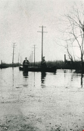
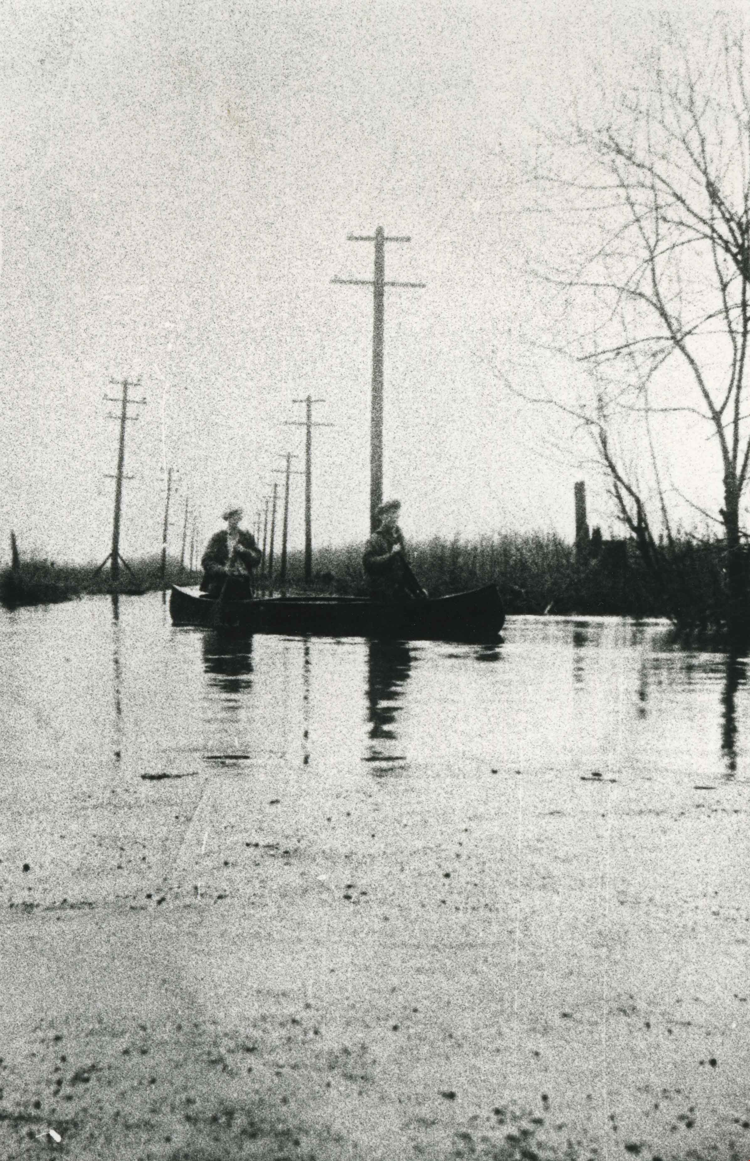
Burnaby Lake flooding
https://search.heritageburnaby.ca/link/archivedescription35571
- Repository
- City of Burnaby Archives
- Date
- 1932 (date of original), copied 1986
- Collection/Fonds
- Burnaby Historical Society fonds
- Description Level
- Item
- Physical Description
- 1 photograph : b&w ; 12.7 x 17.8 cm print
- Scope and Content
- Photograph taken the year of the big flood. Burnaby Lake rose and inundated Sperling Avenue, forcing people to canoe or boat along the avenue.
- Repository
- City of Burnaby Archives
- Date
- 1932 (date of original), copied 1986
- Collection/Fonds
- Burnaby Historical Society fonds
- Subseries
- Pioneer Tales subseries
- Physical Description
- 1 photograph : b&w ; 12.7 x 17.8 cm print
- Description Level
- Item
- Record No.
- 204-429
- Access Restriction
- No restrictions
- Reproduction Restriction
- No known restrictions
- Accession Number
- BHS1988-03
- Scope and Content
- Photograph taken the year of the big flood. Burnaby Lake rose and inundated Sperling Avenue, forcing people to canoe or boat along the avenue.
- Media Type
- Photograph
- Notes
- Title based on contents of photograph
- Geographic Access
- Sperling Avenue
- Historic Neighbourhood
- Burnaby Lake (Historic Neighbourhood)
- Planning Study Area
- Burnaby Lake Area
Images
![Glen Boal and Tom Boal, [between 1935 and 1939] thumbnail](/media/hpo/_Data/_BVM_Images/2017/201700280041_001.jpg?width=280)
Glen Boal and Tom Boal
https://search.heritageburnaby.ca/link/museumdescription4244
- Repository
- Burnaby Village Museum
- Date
- [between 1935 and 1939]
- Collection/Fonds
- Burnaby Village Museum Photograph collection
- Description Level
- Item
- Physical Description
- 1 photograph : b&w print ; 10 x 15 cm
- Scope and Content
- Photograph of Tom and Glen Boal, sitting in an old tree in the back yard of their home on Norland Avenue. The back of the Boal house and raspberry canes are in the background. 4319 Norland Ave
- Repository
- Burnaby Village Museum
- Collection/Fonds
- Burnaby Village Museum Photograph collection
- Description Level
- Item
- Physical Description
- 1 photograph : b&w print ; 10 x 15 cm
- Material Details
- Handwritten text in ink on back reads: "Tom & Glen Boal Norland Ave. / late 1930's. They grew raspberries & / shipped them by train back East & / grew bulbs (daffodils) & sold to Forest Lawn / Glen's dad had lost an eye in the 1st WW / & had TB. Spent time in sanitorium of / TRANQUILLE" .
- Scope and Content
- Photograph of Tom and Glen Boal, sitting in an old tree in the back yard of their home on Norland Avenue. The back of the Boal house and raspberry canes are in the background. 4319 Norland Ave
- Names
- Boal, Glen
- Boal, Thomas "Tom"
- Geographic Access
- Norland Avenue
- Accession Code
- BV017.28.41
- Access Restriction
- No restrictions
- Reproduction Restriction
- No known restrictions
- Date
- [between 1935 and 1939]
- Media Type
- Photograph
- Historic Neighbourhood
- Burnaby Lake (Historic Neighbourhood)
- Planning Study Area
- Burnaby Lake Area
- Scan Resolution
- 600
- Scan Date
- 06-Mar-2018
- Notes
- Title based on contents of photograph
Images
![Glen Boal and Tom Boal, [between 1935 and 1939] thumbnail](/media/hpo/_Data/_BVM_Images/2017/201700280041_001.jpg)
![Glen Boal and Tom Boal, [between 1935 and 1939] thumbnail](/media/hpo/_Data/_BVM_Images/2017/201700280042_001.jpg?width=280)
Glen Boal and Tom Boal
https://search.heritageburnaby.ca/link/museumdescription4245
- Repository
- Burnaby Village Museum
- Date
- [between 1935 and 1939]
- Collection/Fonds
- Burnaby Village Museum Photograph collection
- Description Level
- Item
- Physical Description
- 1 photograph : b&w print ; 10 x 15 cm
- Scope and Content
- Photograph of Tom and Glen Boal, sitting on a stone pile on Norland Avenue.
- Repository
- Burnaby Village Museum
- Collection/Fonds
- Burnaby Village Museum Photograph collection
- Description Level
- Item
- Physical Description
- 1 photograph : b&w print ; 10 x 15 cm
- Material Details
- Handwritten text in ink on back reads: "Glen Boal & Tom Boal Norland Ave. / Burnaby late 1930's".
- Scope and Content
- Photograph of Tom and Glen Boal, sitting on a stone pile on Norland Avenue.
- Names
- Boal, Glen
- Boal, Thomas "Tom"
- Geographic Access
- Norland Avenue
- Accession Code
- BV017.28.42
- Access Restriction
- No restrictions
- Reproduction Restriction
- No known restrictions
- Date
- [between 1935 and 1939]
- Media Type
- Photograph
- Historic Neighbourhood
- Burnaby Lake (Historic Neighbourhood)
- Planning Study Area
- Burnaby Lake Area
- Scan Resolution
- 600
- Scan Date
- 06-Mar-2018
- Notes
- Title based on contents of photograph
Images
![Glen Boal and Tom Boal, [between 1935 and 1939] thumbnail](/media/hpo/_Data/_BVM_Images/2017/201700280042_001.jpg)
![Interview with Ellen and Bill Schwartz, [1969-2023] (interview content), interviewed 15 May 2023 thumbnail](/media/hpo/_Data/_BVM_Sound_Recordings/Oral_Histories/2023_0016_0006_001.jpg?width=280)
Interview with Ellen and Bill Schwartz
https://search.heritageburnaby.ca/link/museumdescription19602
- Repository
- Burnaby Village Museum
- Date
- [1969-2023] (interview content), interviewed 15 May 2023
- Collection/Fonds
- Burnaby Village Museum fonds
- Description Level
- Item
- Physical Description
- 2 sound recordings (wav) (68 min., 52 sec.) + 1 sound recording (mp3) (68 min., 53 sec.)
- Scope and Content
- Item consists of a recording of an oral history interview with Ellen and Bill Schwartz conducted by Burnaby Village Museum Registrar and Researcher, Eric Damer. 00:00-16:47 Bill and Ellen share where they were born, grew up and went to school as citizens of the United States and how they met in Pe…
- Repository
- Burnaby Village Museum
- Collection/Fonds
- Burnaby Village Museum fonds
- Series
- Museum Oral Histories series
- Subseries
- Many Voices Project Interviews subseries
- Description Level
- Item
- Physical Description
- 2 sound recordings (wav) (68 min., 52 sec.) + 1 sound recording (mp3) (68 min., 53 sec.)
- Material Details
- Interviewer: Eric Damer Interviewees: Ellen and Bill Schwartz Location of Interview: Burnaby Village Museum Interview Date: May 15, 2023 Total Number of tracks: 2 Total Length of all Tracks: 01:08:52 Digital master recordings (wav) were recorded onto two separate audio tracks, edited and merged together and converted to mp3 for access on Heritage Burnaby Photograph information: Bill and Ellen Schwartz.
- Scope and Content
- Item consists of a recording of an oral history interview with Ellen and Bill Schwartz conducted by Burnaby Village Museum Registrar and Researcher, Eric Damer. 00:00-16:47 Bill and Ellen share where they were born, grew up and went to school as citizens of the United States and how they met in Pennsylvania the 1970s. Bill and Ellen explain how in the 1970s, they were discouraged about the current politics in the United States under the Nixon administration and how they were inspired by the “back to the land” ideals, rejecting materialism and wanting an alternative lifestyle. With these ideals in mind, they recall how in 1972 they and a few other friends decided to leave the United States, move to British Columbia with the goal of buying land in the Okanagan or Kootenay region and starting a new lifestyle for themselves. Bill and Ellen recollect how they purchased 20 acres of land in Galena Bay in the Kootenays and how they lived in the area off and on until the early 1980s. They describe how they cleared three acres of land, built a cabin, put in a garden, chicken coop and honey bees. With the challenges of the isolated location and no access to electricity they explain how they decided that they had to live elsewhere in order to make a living. Ellen talks about working as a special education teacher in Revelstoke and Slocan and how Bill obtained his teaching certificate while they lived in Nelson. Bill and Ellen describe themselves as environmentalists and of how they both became active Provincial environmentalists during the construction of the Revelstoke Dam. Bill talks about getting work with the “Energy Van” program talking about energy conservation, renewable energy and recycling. They explain how after their first child was born in 1980, they returned to Galena Bay for about a year and a half until Bill was offered a job with the Department of Energy Conservation which lead them to move to Vancouver. 16:48 – 22:46 Bill and Ellen describe their first few years of living in Vancouver and at University of British Columbia while Ellen completed her master’s degree in creative writing. During this time, they had their second child. They recall how in 1988 how they purchased a house in Burnaby, selecting to live in the Deer Lake neighbourhood. They talk about the benefits of the neighbourhood including; a French immersion school for their children, proximity to the trails around Deer Lake and having transit close by. 22:47 – 33:55 Bill and Ellen talk about their consulting business “Polestar Communications”. A Burnaby based communications consulting firm composed of three people, Ellen and Bill and colleague Richard Banner. They describe how their business got started and some of the projects that they’ve worked on including; BC Hydro’s Power Smart Program, financial literacy curriculum that was introduced in B.C. schools and reports for the Province of British Columbia. Ellen and Bill convey how Bill has been a very active member with the City of Burnaby Environment Committee, the Steering Committee to develop a sustainable environmental strategy for Burnaby, how he’s been awarded for his contributions in coaching youth sports and other areas in which they have both volunteered. 33:56 – 43:07 Ellen describes how she got started in writing educational resources about the environment and how since she completed grad school in 1984, she’s published nineteen books. Ellen conveys how her first book was published and sold to the Province of British Columbia as part of the B.C. educational curriculum on the environment. Ellen talks about some of the children’s books that she’s written and published with themes including; social justice, the labour movement and racism in sports. Ellen describes some of her books and the research that she’s done. 43:08 – 51:04 Ellen and Bill Schwartz reflect on what they like about living in Burnaby. They talk about the benefits of their neighbourhood including; performances at the Shadbolt Centre for the Arts, the Burnaby Blues and Roots Festival, the Burnaby Art Gallery and Deer Lake as well as having access to parks and community centres in Burnaby. 51:05-56:36 Bill and Ellen reflect on their involvement in the Jewish community, considering themselves non-secular Jews. Ellen talks about how they were involved with “Burquest” a Jewish Community Association and how they often observe some of the Jewish holidays including Hanukah and traditions including the Jewish coming of age ritual, bar mitzvah (masc.) and bat mistvah (fem.). Ellen mentions her involvement with the “Jone Betty Stuchner Oy Vey! Funniest Children’s book Award” where she acts a judge and her involvement with the Jewish Book festival and that she is a recipient of the Jewish Book award. 56:37 – 1:08:53 Bill and Ellen reflect on their 35 years living in Burnaby and how they’ve seen it change. They talk about the increased development and density in the city, how they are troubled by a lack of low income housing, the benefits and importance of public transportation and preservation of green space including Burnaby parks.
- History
- Interviewees' biographies: Ellen Schwartz was born in Washington, DC, (1950) but grew up in New Jersey. She attended the Universities of Chicago and Wisconsin before moving to a farm in Pennsylvania, where she met her future husband Bill Schwartz. Bill Schwartz grew up in and around Philadelphia (b. 1947), and attended Pennsylvania State University. After travelling, and discouraged with life in eastern America, he and Ellen decided that British Columbia held better prospects. Bill and Ellen quit their jobs in 1972 and moved to the Kootenay region where they adopted a “back to the land” lifestyle, a very new experience for both of them. After eight years of modest success, and occasional work in nearby towns, they opted to return to Vancouver where Bill had work and where they could raise a family more easily. They rented in Vancouver for a few years before moving to family housing at UBC, while Ellen studied creative writing. Bill founded a communications and writing company, and in 1988 they purchased a home in Burnaby. Ellen launched a new career as a writer, mainly for children young adults. Both were active in their careers, raising a family, and participating in local social and political activities. Interviewer biography: Eric Damer is a Burnaby Village Museum Interpreter, Museum Registrar, Researcher and Blacksmith. Eric pounded hot steel for the first time in 1977 in junior high. Fifteen years later, he joined Burnaby Village Museum where he has smithed for three decades. He also provides historical research for museum exhibits and special projects. Outside the museum, Eric is a social historian with a special interest in educational history.
- Creator
- Burnaby Village Museum
- Subjects
- Education
- Environmental Issues
- Environmental Issues - Environmental Protection
- Geographic Features
- Geographic Features - Parks
- Housing
- Occupations
- Occupations - Entrepreneurs
- Occupations - Writers
- Persons - Volunteers
- Persons - Jewish Canadians
- Social Issues
- Social Issues - Racism
- Religions
- Religions - Judaism
- Names
- Schwartz, William "Bill"
- Schwartz, Ellen
- City of Burnaby
- Polestar Communications
- British Columbia Hydro and Power Authority
- Responsibility
- Damer, Eric
- Accession Code
- BV023.16.6
- Access Restriction
- No restrictions
- Reproduction Restriction
- No known restrictions
- Date
- [1969-2023] (interview content), interviewed 15 May 2023
- Media Type
- Sound Recording
- Historic Neighbourhood
- Burnaby Lake (Historic Neighbourhood)
- Planning Study Area
- Burnaby Lake Area
- Notes
- Title based on contents of item
- Transcription available on Heritage Burnaby
Images
![Interview with Ellen and Bill Schwartz, [1969-2023] (interview content), interviewed 15 May 2023 thumbnail](/media/hpo/_Data/_BVM_Sound_Recordings/Oral_Histories/2023_0016_0006_001.jpg)
Documents
Audio Tracks
Interview with Ellen and Bill Schwartz, [1969-2023] (interview content), interviewed 15 May 2023
Interview with Ellen and Bill Schwartz, [1969-2023] (interview content), interviewed 15 May 2023
https://search.heritageburnaby.ca/media/hpo/_Data/_BVM_Sound_Recordings/Oral_Histories/2023_0016_0006_003.mp3![Map of proposed provincial exhibition site at Burnaby Lake, [between 1929 and 1931] thumbnail](/media/hpo/_Data/_BVM_Cartographic_Material/2017/2017_0002_0009_005.jpg?width=280)
Map of proposed provincial exhibition site at Burnaby Lake
https://search.heritageburnaby.ca/link/museumdescription8703
- Repository
- Burnaby Village Museum
- Date
- [between 1929 and 1931]
- Collection/Fonds
- Burnaby Village Museum Map collection
- Description Level
- Item
- Physical Description
- 1 map : photostat print ; 3 parts 45 x 33.7 cm totalling 45 x 101 cm
- Scope and Content
- Item consists of a tri-part folding map of a proposed Provincial Exhibition site located along the southern and western shore of Burnaby Lake. Exhibtion site on map identifies proposed locations for a golf course, pier, hydroplane landing ramp, sports ground, one-mile horse racing track and various…
- Repository
- Burnaby Village Museum
- Collection/Fonds
- Burnaby Village Museum Map collection
- Description Level
- Item
- Physical Description
- 1 map : photostat print ; 3 parts 45 x 33.7 cm totalling 45 x 101 cm
- Material Details
- Scale [1:1800]
- Scope and Content
- Item consists of a tri-part folding map of a proposed Provincial Exhibition site located along the southern and western shore of Burnaby Lake. Exhibtion site on map identifies proposed locations for a golf course, pier, hydroplane landing ramp, sports ground, one-mile horse racing track and various buildings for mechanical, agricultural and botanical displays.
- Subjects
- Exhibitions
- Accession Code
- BV017.2.9
- Access Restriction
- No restrictions
- Reproduction Restriction
- No known restrictions
- Date
- [between 1929 and 1931]
- Media Type
- Cartographic Material
- Historic Neighbourhood
- Burnaby Lake (Historic Neighbourhood)
- Planning Study Area
- Burnaby Lake Area
- Scan Resolution
- 400
- Scan Date
- 2021-11-18
- Notes
- Title based on contents of map
- Scale on map reads: "150 feet to 1 inch"
- Overall measurements when fully opened: L: 98.0 cm x H: 45.3 cm ; Individual map parts: L: 32.7 cm x H: 45.0 cm
- Commercially printed label on front of portfolio card reads "PLOWRIGHT PRINTING COMPANY / TELEPHONE N.W. 1942 / 39 McKENZIE STREET NEW WESTMINSTER, B.C. / TO: [illegible writing in pencil]" in blue ink. Red typewritten text reads: "PHOTOSTAT OF BURNABY LAKE".
Images
![Map of proposed provincial exhibition site at Burnaby Lake, [between 1929 and 1931] thumbnail](/media/hpo/_Data/_BVM_Cartographic_Material/2017/2017_0002_0009_005.jpg)


