Narrow Results By
Person / Organization
- Burnaby Central Secondary School 1
- Ceperley, H.T. 2
- Douglas Road School 1
- Dowad, Kathleen "Kay" 1
- Dowad, Martha Elias Shaheen 1
- Dowad, Naomi "Mamie" David 1
- Dowad, Norman W. "Norm" 1
- Dowad, Samuel Esper "Sam" 1
- Dowad, Wilfred "Wilf" 1
- Hart, Frederick John, 1884-1945 2
- Haszard, Arthur de Windt 2
- Hill, Arthur Claude 2

Backyard Fence at 5573 Buckingham Avenue
https://search.heritageburnaby.ca/link/archivedescription78982
- Repository
- City of Burnaby Archives
- Date
- September 24, 1976
- Collection/Fonds
- Burnaby Public Library Contemporary Visual Archive Project
- Description Level
- Item
- Physical Description
- 1 photograph : b&w ; 11 x 16 cm mounted on cardboard
- Scope and Content
- Photograph shows a woodshed, toolshed and fence behind the John D. and Katherine Shearer House at 5573 Buckingham Avenue near Haszard Street. The house was built in 1912, renovated in 1940s and the fence added in the 1950s.
- Repository
- City of Burnaby Archives
- Date
- September 24, 1976
- Collection/Fonds
- Burnaby Public Library Contemporary Visual Archive Project
- Physical Description
- 1 photograph : b&w ; 11 x 16 cm mounted on cardboard
- Description Level
- Item
- Record No.
- 556-067
- Access Restriction
- No restrictions
- Reproduction Restriction
- Reproduce for fair dealing purposes only
- Accession Number
- 2013-13
- Scope and Content
- Photograph shows a woodshed, toolshed and fence behind the John D. and Katherine Shearer House at 5573 Buckingham Avenue near Haszard Street. The house was built in 1912, renovated in 1940s and the fence added in the 1950s.
- Subjects
- Buildings - Heritage
- Media Type
- Photograph
- Photographer
- Born, A. J.
- Notes
- Scope note taken directly from BPL photograph description.
- 1 b&w copy negative : 10 x 12.5 cm accompanying
- Geographic Access
- Buckingham Avenue
- Street Address
- 5573 Buckingham Avenue
- Historic Neighbourhood
- Burnaby Lake (Historic Neighbourhood)
- Planning Study Area
- Morley-Buckingham Area
Images


Bird's Eye View of the Burnaby Lake Area
https://search.heritageburnaby.ca/link/museumdescription15144
- Repository
- Burnaby Village Museum
- Date
- 1977
- Collection/Fonds
- Century Park Museum Association fonds
- Description Level
- Item
- Physical Description
- 1 map : b&w print on paper ; 43 x 63.5 cm
- Scope and Content
- Item consists of a map titled "Birds Eye View of the Burnaby Lake Area Circa 1910". The overview of the Burnaby Lake area was compiled and drawn at Heritage Village by curator John Adams and artist, Carol Swan. The map identifies the Burnaby Lake inter-urban tram line; roads including: Sperling Ave…
- Repository
- Burnaby Village Museum
- Collection/Fonds
- Century Park Museum Association fonds
- Description Level
- Item
- Physical Description
- 1 map : b&w print on paper ; 43 x 63.5 cm
- Material Details
- Scale indeterminable
- Scope and Content
- Item consists of a map titled "Birds Eye View of the Burnaby Lake Area Circa 1910". The overview of the Burnaby Lake area was compiled and drawn at Heritage Village by curator John Adams and artist, Carol Swan. The map identifies the Burnaby Lake inter-urban tram line; roads including: Sperling Avenue (Pole Line Road); Gilpin Avenue; Douglas Road; trail to Vancouver Westminster Road (Kingsway); Buckingham Avenue; Haszard Street; various farms and residences including: Charles Sprott "Norland"; H.T. Ceperley "Fairacres"; Claude Hill's "Brookfield farm" and "Broadview"; F.J. Hart's "Avalon"; Miss Woodward's former and new home, school and post office; Councillor Edgar's hunting cabin; Edgar Sprott's "Mayfield farm" and "Mayfield Lodge"; F.J. Peers "Greyfriars"; Arthur de Windt Haszard; Bernard Hill's boathouse as well as other landmarks including: Doran's Mill; tram stations; Burnaby Lake Store; logging camps; wood cutter's shacks; ice houses; cranberry bog; Still Creek; Deer Lake; Burnaby Lake; Deer Lake Creek; Provincial Government Reserve Proposed Hospital (later Oakalla Prison).
- Creator
- Adams, John
- Swan, Carol
- Names
- Hill, Arthur Claude
- Sprott, Charles Frederick
- Sprott, Louis "Edgar"
- Hart, Frederick John, 1884-1945
- Ceperley, H.T.
- Woodward, Maude
- Woodward, Harriet
- Peers, Francis J.
- Haszard, Arthur de Windt
- Hill, Bernard R.
- Geographic Access
- Deer Lake Avenue
- Sperling Avenue
- Haszard Street
- Buckingham Avenue
- Accession Code
- BV021.1.3
- Access Restriction
- No restrictions
- Reproduction Restriction
- No known restrictions
- Date
- 1977
- Media Type
- Cartographic Material
- Historic Neighbourhood
- Burnaby Lake (Historic Neighbourhood)
- Planning Study Area
- Burnaby Lake Area
- Related Material
- See also: Life with the Moores of Hart House : pioneer days on Burnaby's Deer Lake
- Scan Resolution
- 600
- Scan Date
- 2021-11-12
- Scale
- 100
- Notes
- Transcribed title
- Compiled by John Adams; illustration by Carol Swan
- The map depicts the Burnaby Lake Tram Line as being double tracked, whereas in reality it was single tracked.
- Map is part of the book "Life with the Moores of Hart House : pioneer days on Burnaby's Deer Lake https://search.heritageburnaby.ca/permalink/museumlibrary6314-102
Images


Bird's Eye View of the Burnaby Lake Area
https://search.heritageburnaby.ca/link/museumdescription17543
- Repository
- Burnaby Village Museum
- Date
- 1977
- Collection/Fonds
- Century Park Museum Association fonds
- Description Level
- Item
- Physical Description
- 1 map : b&w print with watercolour ; 43 x 63.5 cm
- Scope and Content
- Item consists of a map titled "Birds Eye View of the Burnaby Lake Area Circa 1910". The overview of the Burnaby Lake area was compiled and drawn at Heritage Village by curator John Adams and artist, Carol Swan. The map identifies the Burnaby Lake inter-urban tram line; roads including: Sperling Ave…
- Repository
- Burnaby Village Museum
- Collection/Fonds
- Century Park Museum Association fonds
- Description Level
- Item
- Physical Description
- 1 map : b&w print with watercolour ; 43 x 63.5 cm
- Material Details
- Scale indeterminable
- Scope and Content
- Item consists of a map titled "Birds Eye View of the Burnaby Lake Area Circa 1910". The overview of the Burnaby Lake area was compiled and drawn at Heritage Village by curator John Adams and artist, Carol Swan. The map identifies the Burnaby Lake inter-urban tram line; roads including: Sperling Avenue (Pole Line Road); Gilpin Avenue; Douglas Road; trail to Vancouver Westminster Road (Kingsway); Buckingham Avenue; Haszard Street; various farms and residences including: Charles Sprott "Norland"; H.T. Ceperley "Fairacres"; Claude Hill's "Brookfield farm" and "Broadview"; F.J. Hart's "Avalon"; Miss Woodward's former and new home, school and post office; Councillor Edgar's hunting cabin; Edgar Sprott's "Mayfield farm" and "Mayfield Lodge"; F.J. Peers "Greyfriars"; Arthur de Windt Haszard; Bernard Hill's boathouse as well as other landmarks including: Doran's Mill; tram stations; Burnaby Lake Store; logging camps; wood cutter's shacks; ice houses; cranberry bog; Still Creek; Deer Lake; Burnaby Lake; Deer Lake Creek; Provincial Government Reserve Proposed Hospital (later Oakalla Prison).
- Creator
- Adams, John
- Swan, Carol
- Names
- Hill, Arthur Claude
- Sprott, Charles Frederick
- Sprott, Louis "Edgar"
- Hart, Frederick John, 1884-1945
- Ceperley, H.T.
- Woodward, Maude
- Woodward, Harriet
- Peers, Francis J.
- Haszard, Arthur de Windt
- Hill, Bernard R.
- Geographic Access
- Deer Lake Avenue
- Sperling Avenue
- Haszard Street
- Buckingham Avenue
- Accession Code
- BV021.1.4
- Access Restriction
- No restrictions
- Reproduction Restriction
- No known restrictions
- Date
- 1977
- Media Type
- Cartographic Material
- Historic Neighbourhood
- Burnaby Lake (Historic Neighbourhood)
- Planning Study Area
- Burnaby Lake Area
- Related Material
- See also: Life with the Moores of Hart House : pioneer days on Burnaby's Deer Lake
- Scan Resolution
- 600
- Scan Date
- 2021-11-12
- Scale
- 100
- Notes
- Transcribed title
- Compiled by John Adams; illustration by Carol Swan
- The map depicts the Burnaby Lake Tram Line as being double tracked, whereas in reality it was single tracked.
- Map is part of the book "Life with the Moores of Hart House : pioneer days on Burnaby's Deer Lake https://search.heritageburnaby.ca/permalink/museumlibrary6314-102
- This is a print made from original illustration and appears to be hand-coloured with watercolour at a later date.
Images

Interview with Norman Dowad
https://search.heritageburnaby.ca/link/museumdescription19638
- Repository
- Burnaby Village Museum
- Date
- [1890-2023] (interview content), interviewed 14 Aug. 2023
- Collection/Fonds
- Burnaby Village Museum fonds
- Description Level
- Item
- Physical Description
- 1 sound recording (wav) (61 min., 37 sec.) + 1 sound recording (mp3) (61 min., 37 sec.)
- Scope and Content
- Item consists of a recording of an oral history interview with Norman Dowad conducted by Burnaby Village Museum Registrar, Eric Damer on August 14, 2023. 00:00:00 – 00:14:38 Norm shares biographical information about himself and background information on the Dowad family. Norm conveys information …
- Repository
- Burnaby Village Museum
- Collection/Fonds
- Burnaby Village Museum fonds
- Series
- Museum Oral Histories series
- Subseries
- Many Voices Project Interviews subseries
- Description Level
- Item
- Physical Description
- 1 sound recording (wav) (61 min., 37 sec.) + 1 sound recording (mp3) (61 min., 37 sec.)
- Material Details
- Interviewer: Eric Damer Interviewee: Norman Dowad Location of Interview: Burnaby Village Museum Interview Date: August 14, 2023 Total Number of tracks: 1 Total Length of all Tracks: 01:14:37 Digital master recording (wav) was converted to mp3 for access on Heritage Burnaby
- Scope and Content
- Item consists of a recording of an oral history interview with Norman Dowad conducted by Burnaby Village Museum Registrar, Eric Damer on August 14, 2023. 00:00:00 – 00:14:38 Norm shares biographical information about himself and background information on the Dowad family. Norm conveys information about his grandfather Samuel Dowad's immigration to Canada and his father Wilfred Dowad's military service and successes as a property developer. 00:14:39 – 00:17:26 Norm provides background information on his mother’s side of the family. 00:17:27 – 00:31:36 Norm talks about his childhood, growing up in the Deer Lake neighbourhood, his early education in Burnaby and sports that he played. 00:31:37 – 00:39:59 Norm talks about his educational experiences attending Simon Fraser University, University of British Columbia and Osgoode Hall law school and information regarding his law career. 00:40:00 – 00:45:03 Norm reflects on his childhood growing up in Burnaby and on his experiences and relationships as a student and in his career as a lawyer. 00:45:04 – 01:01:37 Norm talks about his siblings and shares information about family property development projects as well as career and business successes. In closing he talks about research that he’s done through Archives Canada on his grandfather Sam Dowad and father Wilfred Dowad.
- History
- Interviewee biography: Norm Dowad was born in Burnaby, December 1948 to parents Wilfred “Wilf” (1925-2011) and Cherry Dowad. His father, Wilfred (1925-2011) was born in Winnipeg to parents Samuel “Sam” (Salim in Arabic) Esper Dowad (1895-1969) and Martha (Shaheen) Dowad (1894-1955). Sam and Martha Dowad were both born in a province of the Ottoman Empire which is now present day Lebanon. In 1912, while trying to immigrate to Canada, several of Sam’s relatives including his mother died tragically as steerage passengers on the ill fated Titanic. In 1913, at the age of 18 years, Sam immigrated to Canada to join other family members who'd already arrived here safely. As a new immigrant in Canada, Sam worked with other Labanese immigrants in Saskatchewan, Manitoba and the United States. In December 1921, Sam's wife, Martha immigrated to Canada arriving by ship in St. John, New Brunswick. Sam and Martha established their home in Winnipeg where they began to start a family. Their first two children died in infancy and son Wilfred was born in 1925 and daughter Kathleen was born in 1926. While living in Winnipeg, Sam worked as a grocer and in the 1930’s he got work as a farmer in a nearby town. In 1943, Wilf joined the Royal Canadian Naval Volunteer Reserve (RCVNR) and served as a gunner on merchant ships during World War II. In 1945, while Wilf was away serving, his parents, Sam and Martha moved to Burnaby. After discharge in 1945, Wilf joined his parents in Burnaby, began working at Fraser Mills and commenced his studies in construction and drafting. In 1949, with his father’s help Wilf acquired a lot next door to his parents’ home and built his first apartment block. After Martha died in 1954, Sam moved to Kelowna where he bought an orchard. Sam remarried in 1957 to Naomi “Mamie” (David) Dowad (1899-1978) who was also from a Lebanese family. Sam and Mamie lived in Kelowna until the mid 1960s when they moved to White Rock. While living in Burnaby, Wilf met and married Cherry Piggott and the couple had six children; Norm, Bruce, Michael, Kathie, Phil and Tom. In 1955, Wilfred Dowad established "W. Dowad Ltd." and over the years he was successful in developing and subdividing land to build housing and commercial developments in Burnaby, New Westminster and Vancouver. Wilf was the first president of the Burnaby Winter club and was an active member of the Junior Chamber of Commerce holding office at the local, provincial and national level. In 1970, Wilf purchased 238 acres of land bordering the Sḵwx̱wú7mesh River and relocated there the following year. While living in Sḵwx̱wú7mesh, Wilf became actively engaged in local business and community affairs. Wilf was later remarried to Grethe Dowad and he died in Sḵwx̱wú7mesh in 2011.Wilf's six children are the sole owners of "W.Dowad Ltd." and his daughter, Kathie Smillie is the president and CEO. While growing up in Burnaby, Norm Dowad attended Schou Street School, Douglas Road School, Kensington School and graduated from Burnaby Central Secondary School. Following graduation from high school, Norm attended Simon Fraser University for one year, travelled in Europe, attended University of British Columbia and obtained his law degree from Osgoode Hall at York University. Norman has been practicing law for 49 years and has his own law practice that he operates out of Vancouver. Interviewer biography: Eric Damer is a Burnaby Village Museum Interpreter, Museum Registrar, Researcher and Blacksmith. Eric pounded hot steel for the first time in 1977 in junior high. Fifteen years later, he joined Burnaby Village Museum where he has smithed for three decades. He also provides historical research for museum exhibits and special projects. Outside the museum, Eric is a social historian with a special interest in educational history.
- Creator
- Burnaby Village Museum
- Subjects
- Agriculture - Farms
- Education
- Persons - South Asian Canadians
- Migration
- Sports
- Sports - Football
- Wars - World War, 1939-1945
- Names
- Dowad, Norman W. "Norm"
- Dowad, Samuel Esper "Sam"
- Dowad, Wilfred "Wilf"
- Dowad, Naomi "Mamie" David
- Dowad, Martha Elias Shaheen
- Dowad, Kathleen "Kay"
- Rideout, Dr. John Anthony
- Burnaby Central Secondary School
- Douglas Road School
- W. Dowad Limited
- Responsibility
- Damer, Eric
- Geographic Access
- Buckingham Avenue
- Deer Lake
- Street Address
- 5533 Buckingham Avenue
- Accession Code
- BV023.16.16
- Access Restriction
- No restrictions
- Reproduction Restriction
- No known restrictions
- Date
- [1890-2023] (interview content), interviewed 14 Aug. 2023
- Media Type
- Sound Recording
- Historic Neighbourhood
- Burnaby Lake (Historic Neighbourhood)
- Planning Study Area
- Morley-Buckingham Area
- Notes
- Title based on contents of item
- Transcription available
Documents
Audio Tracks
Interview with Norman Dowad, [1890-2023] (interview content), interviewed 14 Aug. 2023
Interview with Norman Dowad, [1890-2023] (interview content), interviewed 14 Aug. 2023
https://search.heritageburnaby.ca/media/hpo/_Data/_BVM_Sound_Recordings/Oral_Histories/2023_0016_0016_002.mp3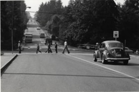
School Crosswalk
https://search.heritageburnaby.ca/link/archivedescription79606
- Repository
- City of Burnaby Archives
- Date
- September 24, 1976
- Collection/Fonds
- Burnaby Public Library Contemporary Visual Archive Project
- Description Level
- Item
- Physical Description
- 1 photograph : b&w ; 11 x 16 cm mounted on cardboard
- Scope and Content
- Photograph shows pedestrians using school crosswalk at the corner of Burris Street and Buckingham Avenue, near Buckingham Elementary School. Two members of the school's traffic patrol are holding back traffic as people cross.
- Repository
- City of Burnaby Archives
- Date
- September 24, 1976
- Collection/Fonds
- Burnaby Public Library Contemporary Visual Archive Project
- Physical Description
- 1 photograph : b&w ; 11 x 16 cm mounted on cardboard
- Description Level
- Item
- Record No.
- 556-350
- Access Restriction
- No restrictions
- Reproduction Restriction
- Reproduce for fair dealing purposes only
- Accession Number
- 2013-13
- Scope and Content
- Photograph shows pedestrians using school crosswalk at the corner of Burris Street and Buckingham Avenue, near Buckingham Elementary School. Two members of the school's traffic patrol are holding back traffic as people cross.
- Media Type
- Photograph
- Photographer
- Norton, Paul
- Notes
- Scope note taken directly from BPL photograph description.
- 1 b&w copy negative : 10 x 12.5 cm accompanying
- Geographic Access
- Buckingham Avenue
- Historic Neighbourhood
- Burnaby Lake (Historic Neighbourhood)
- Planning Study Area
- Morley-Buckingham Area
Images
