Narrow Results By
Subject
- Agricultural Tools and Equipment 1
- Agriculture - Crops 2
- Agriculture - Farms 3
- Animals - Cows 1
- Animals - Dogs 4
- Animals - Horses 3
- Buildings - Heritage 2
- Buildings - Residential 1
- Buildings - Residential - Cabins 1
- Buildings - Residential - Houses 24
- Buildings - Schools 1
- Clothing - Military Uniforms 2
Person / Organization
- Buckingham Elementary School 3
- Burnaby Central Secondary School 1
- Ceperley, H.T. 2
- Clayton, Edith 6
- Clayton, Edward 1
- Douglas Road School 1
- Dowad, Kathleen "Kay" 1
- Dowad, Martha Elias Shaheen 1
- Dowad, Naomi "Mamie" David 1
- Dowad, Norman W. "Norm" 1
- Dowad, Samuel Esper "Sam" 1
- Dowad, Wilfred "Wilf" 1
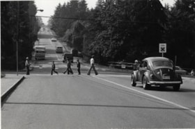
School Crosswalk
https://search.heritageburnaby.ca/link/archivedescription79606
- Repository
- City of Burnaby Archives
- Date
- September 24, 1976
- Collection/Fonds
- Burnaby Public Library Contemporary Visual Archive Project
- Description Level
- Item
- Physical Description
- 1 photograph : b&w ; 11 x 16 cm mounted on cardboard
- Scope and Content
- Photograph shows pedestrians using school crosswalk at the corner of Burris Street and Buckingham Avenue, near Buckingham Elementary School. Two members of the school's traffic patrol are holding back traffic as people cross.
- Repository
- City of Burnaby Archives
- Date
- September 24, 1976
- Collection/Fonds
- Burnaby Public Library Contemporary Visual Archive Project
- Physical Description
- 1 photograph : b&w ; 11 x 16 cm mounted on cardboard
- Description Level
- Item
- Record No.
- 556-350
- Access Restriction
- No restrictions
- Reproduction Restriction
- Reproduce for fair dealing purposes only
- Accession Number
- 2013-13
- Scope and Content
- Photograph shows pedestrians using school crosswalk at the corner of Burris Street and Buckingham Avenue, near Buckingham Elementary School. Two members of the school's traffic patrol are holding back traffic as people cross.
- Media Type
- Photograph
- Photographer
- Norton, Paul
- Notes
- Scope note taken directly from BPL photograph description.
- 1 b&w copy negative : 10 x 12.5 cm accompanying
- Geographic Access
- Buckingham Avenue
- Historic Neighbourhood
- Burnaby Lake (Historic Neighbourhood)
- Planning Study Area
- Morley-Buckingham Area
Images


Bird's Eye View of the Burnaby Lake Area
https://search.heritageburnaby.ca/link/museumdescription17543
- Repository
- Burnaby Village Museum
- Date
- 1977
- Collection/Fonds
- Century Park Museum Association fonds
- Description Level
- Item
- Physical Description
- 1 map : b&w print with watercolour ; 43 x 63.5 cm
- Scope and Content
- Item consists of a map titled "Birds Eye View of the Burnaby Lake Area Circa 1910". The overview of the Burnaby Lake area was compiled and drawn at Heritage Village by curator John Adams and artist, Carol Swan. The map identifies the Burnaby Lake inter-urban tram line; roads including: Sperling Ave…
- Repository
- Burnaby Village Museum
- Collection/Fonds
- Century Park Museum Association fonds
- Description Level
- Item
- Physical Description
- 1 map : b&w print with watercolour ; 43 x 63.5 cm
- Material Details
- Scale indeterminable
- Scope and Content
- Item consists of a map titled "Birds Eye View of the Burnaby Lake Area Circa 1910". The overview of the Burnaby Lake area was compiled and drawn at Heritage Village by curator John Adams and artist, Carol Swan. The map identifies the Burnaby Lake inter-urban tram line; roads including: Sperling Avenue (Pole Line Road); Gilpin Avenue; Douglas Road; trail to Vancouver Westminster Road (Kingsway); Buckingham Avenue; Haszard Street; various farms and residences including: Charles Sprott "Norland"; H.T. Ceperley "Fairacres"; Claude Hill's "Brookfield farm" and "Broadview"; F.J. Hart's "Avalon"; Miss Woodward's former and new home, school and post office; Councillor Edgar's hunting cabin; Edgar Sprott's "Mayfield farm" and "Mayfield Lodge"; F.J. Peers "Greyfriars"; Arthur de Windt Haszard; Bernard Hill's boathouse as well as other landmarks including: Doran's Mill; tram stations; Burnaby Lake Store; logging camps; wood cutter's shacks; ice houses; cranberry bog; Still Creek; Deer Lake; Burnaby Lake; Deer Lake Creek; Provincial Government Reserve Proposed Hospital (later Oakalla Prison).
- Creator
- Adams, John
- Swan, Carol
- Names
- Hill, Arthur Claude
- Sprott, Charles Frederick
- Sprott, Louis "Edgar"
- Hart, Frederick John, 1884-1945
- Ceperley, H.T.
- Woodward, Maude
- Woodward, Harriet
- Peers, Francis J.
- Haszard, Arthur de Windt
- Hill, Bernard R.
- Geographic Access
- Deer Lake Avenue
- Sperling Avenue
- Haszard Street
- Buckingham Avenue
- Accession Code
- BV021.1.4
- Access Restriction
- No restrictions
- Reproduction Restriction
- No known restrictions
- Date
- 1977
- Media Type
- Cartographic Material
- Historic Neighbourhood
- Burnaby Lake (Historic Neighbourhood)
- Planning Study Area
- Burnaby Lake Area
- Related Material
- See also: Life with the Moores of Hart House : pioneer days on Burnaby's Deer Lake
- Scan Resolution
- 600
- Scan Date
- 2021-11-12
- Scale
- 100
- Notes
- Transcribed title
- Compiled by John Adams; illustration by Carol Swan
- The map depicts the Burnaby Lake Tram Line as being double tracked, whereas in reality it was single tracked.
- Map is part of the book "Life with the Moores of Hart House : pioneer days on Burnaby's Deer Lake https://search.heritageburnaby.ca/permalink/museumlibrary6314-102
- This is a print made from original illustration and appears to be hand-coloured with watercolour at a later date.
Images


Bird's Eye View of the Burnaby Lake Area
https://search.heritageburnaby.ca/link/museumdescription15144
- Repository
- Burnaby Village Museum
- Date
- 1977
- Collection/Fonds
- Century Park Museum Association fonds
- Description Level
- Item
- Physical Description
- 1 map : b&w print on paper ; 43 x 63.5 cm
- Scope and Content
- Item consists of a map titled "Birds Eye View of the Burnaby Lake Area Circa 1910". The overview of the Burnaby Lake area was compiled and drawn at Heritage Village by curator John Adams and artist, Carol Swan. The map identifies the Burnaby Lake inter-urban tram line; roads including: Sperling Ave…
- Repository
- Burnaby Village Museum
- Collection/Fonds
- Century Park Museum Association fonds
- Description Level
- Item
- Physical Description
- 1 map : b&w print on paper ; 43 x 63.5 cm
- Material Details
- Scale indeterminable
- Scope and Content
- Item consists of a map titled "Birds Eye View of the Burnaby Lake Area Circa 1910". The overview of the Burnaby Lake area was compiled and drawn at Heritage Village by curator John Adams and artist, Carol Swan. The map identifies the Burnaby Lake inter-urban tram line; roads including: Sperling Avenue (Pole Line Road); Gilpin Avenue; Douglas Road; trail to Vancouver Westminster Road (Kingsway); Buckingham Avenue; Haszard Street; various farms and residences including: Charles Sprott "Norland"; H.T. Ceperley "Fairacres"; Claude Hill's "Brookfield farm" and "Broadview"; F.J. Hart's "Avalon"; Miss Woodward's former and new home, school and post office; Councillor Edgar's hunting cabin; Edgar Sprott's "Mayfield farm" and "Mayfield Lodge"; F.J. Peers "Greyfriars"; Arthur de Windt Haszard; Bernard Hill's boathouse as well as other landmarks including: Doran's Mill; tram stations; Burnaby Lake Store; logging camps; wood cutter's shacks; ice houses; cranberry bog; Still Creek; Deer Lake; Burnaby Lake; Deer Lake Creek; Provincial Government Reserve Proposed Hospital (later Oakalla Prison).
- Creator
- Adams, John
- Swan, Carol
- Names
- Hill, Arthur Claude
- Sprott, Charles Frederick
- Sprott, Louis "Edgar"
- Hart, Frederick John, 1884-1945
- Ceperley, H.T.
- Woodward, Maude
- Woodward, Harriet
- Peers, Francis J.
- Haszard, Arthur de Windt
- Hill, Bernard R.
- Geographic Access
- Deer Lake Avenue
- Sperling Avenue
- Haszard Street
- Buckingham Avenue
- Accession Code
- BV021.1.3
- Access Restriction
- No restrictions
- Reproduction Restriction
- No known restrictions
- Date
- 1977
- Media Type
- Cartographic Material
- Historic Neighbourhood
- Burnaby Lake (Historic Neighbourhood)
- Planning Study Area
- Burnaby Lake Area
- Related Material
- See also: Life with the Moores of Hart House : pioneer days on Burnaby's Deer Lake
- Scan Resolution
- 600
- Scan Date
- 2021-11-12
- Scale
- 100
- Notes
- Transcribed title
- Compiled by John Adams; illustration by Carol Swan
- The map depicts the Burnaby Lake Tram Line as being double tracked, whereas in reality it was single tracked.
- Map is part of the book "Life with the Moores of Hart House : pioneer days on Burnaby's Deer Lake https://search.heritageburnaby.ca/permalink/museumlibrary6314-102
Images

5573-5623 Buckingham Ave
https://search.heritageburnaby.ca/link/archivedescription94323
- Repository
- City of Burnaby Archives
- Date
- November 1994
- Collection/Fonds
- Grover, Elliott & Co. Ltd. fonds
- Description Level
- File
- Physical Description
- 37 photographs : col. negatives ; 35 mm
- Scope and Content
- Photographs of a single-family home located at 5573 Buckingham Avenue and the surrounding property. File also contains photographs of the 5500 and 5600 blocks of Bucking Avenue and the corner of Buckingham Avenue and Haszard Street.
- Repository
- City of Burnaby Archives
- Date
- November 1994
- Collection/Fonds
- Grover, Elliott & Co. Ltd. fonds
- Physical Description
- 37 photographs : col. negatives ; 35 mm
- Description Level
- File
- Record No.
- 622-108
- Access Restriction
- No restrictions
- Reproduction Restriction
- No restrictions
- Accession Number
- 2017-39
- Scope and Content
- Photographs of a single-family home located at 5573 Buckingham Avenue and the surrounding property. File also contains photographs of the 5500 and 5600 blocks of Bucking Avenue and the corner of Buckingham Avenue and Haszard Street.
- Media Type
- Photograph
- Notes
- Transcribed title
- Title transcribed from envelope photographs were originally housed in
- File no. 94-391-B
- Geographic Access
- Buckingham Avenue
- Street Address
- 5573 Buckingham Avenue
- Historic Neighbourhood
- Burnaby Lake (Historic Neighbourhood)
- Planning Study Area
- Morley-Buckingham Area
![Millennium Fair at Buckingham Elementary School, [1999] thumbnail](/media/hpo/_Data/_Archives_Images/_Unrestricted/535/535-3169.jpg?width=280)
Millennium Fair at Buckingham Elementary School
https://search.heritageburnaby.ca/link/archivedescription98089
- Repository
- City of Burnaby Archives
- Date
- [1999]
- Collection/Fonds
- Burnaby NewsLeader photograph collection
- Description Level
- Item
- Physical Description
- 1 photograph (tiff) : col.
- Scope and Content
- Photograph of Buckingham Elementary School students dressed up as Alexander Graham Bell and Thomas Watson with a satellite phone at the school's Millennium Fair.
- Repository
- City of Burnaby Archives
- Date
- [1999]
- Collection/Fonds
- Burnaby NewsLeader photograph collection
- Physical Description
- 1 photograph (tiff) : col.
- Description Level
- Item
- Record No.
- 535-3169
- Access Restriction
- No restrictions
- Reproduction Restriction
- No restrictions
- Accession Number
- 2018-12
- Scope and Content
- Photograph of Buckingham Elementary School students dressed up as Alexander Graham Bell and Thomas Watson with a satellite phone at the school's Millennium Fair.
- Media Type
- Photograph
- Photographer
- Bartel, Mario
- Notes
- Title based on caption
- Collected by editorial for use in a May 1999 issue of the Burnaby NewsLeader
- Caption from metadata: ""Alexander Graham Bell," Clement Luah, 12, a Grade 7 student at Buckingham Elementary, places a call on his satellite phone to his assistant, "Thomas Watson," Brock Fabbro, 11, at the school's Millennium Fair. Students dressed up as historical figures and created exhibits showing how they changed the world in the last 1000 years."
- Geographic Access
- Buckingham Avenue
- Street Address
- 6066 Buckingham Avenue
- Historic Neighbourhood
- Burnaby Lake (Historic Neighbourhood)
- Planning Study Area
- Morley-Buckingham Area
Images
![Millennium Fair at Buckingham Elementary School, [1999] thumbnail](/media/hpo/_Data/_Archives_Images/_Unrestricted/535/535-3169.jpg)
![Buckingham Elementary recycling collectors, [2000] thumbnail](/media/hpo/_Data/_Archives_Images/_Unrestricted/535/535-2438.jpg?width=280)
Buckingham Elementary recycling collectors
https://search.heritageburnaby.ca/link/archivedescription96880
- Repository
- City of Burnaby Archives
- Date
- [2000]
- Collection/Fonds
- Burnaby NewsLeader photograph collection
- Description Level
- Item
- Physical Description
- 1 photograph (tiff) : col.
- Scope and Content
- Photograph of grade 6 students Jennifer Chui, Lindsay Herberts, and Stephanie Standerwich, who collect recyclables during Buckingham Elementary's lunch hour. The school received a provincial environmental award.
- Repository
- City of Burnaby Archives
- Date
- [2000]
- Collection/Fonds
- Burnaby NewsLeader photograph collection
- Physical Description
- 1 photograph (tiff) : col.
- Description Level
- Item
- Record No.
- 535-2438
- Access Restriction
- No restrictions
- Reproduction Restriction
- No restrictions
- Accession Number
- 2018-12
- Scope and Content
- Photograph of grade 6 students Jennifer Chui, Lindsay Herberts, and Stephanie Standerwich, who collect recyclables during Buckingham Elementary's lunch hour. The school received a provincial environmental award.
- Subjects
- Persons - Students
- Environmental Issues
- Media Type
- Photograph
- Photographer
- Bartel, Mario
- Notes
- Title based on caption
- Collected by editorial for use in a June 2000 issue of the Burnaby NewsLeader
- Caption from metadata: "Jennifer Chui, Lindsay Herberts and Stephanie Standerwich are Grade 6 students who cruise the halls of Buckingham Elementary at lunch hour, collecting recyclables. The school has been honored with a provicial envirnmental award."
- Geographic Access
- Buckingham Avenue
- Street Address
- 6066 Buckingham Avenue
- Historic Neighbourhood
- Burnaby Lake (Historic Neighbourhood)
- Planning Study Area
- Morley-Buckingham Area
Images
![Buckingham Elementary recycling collectors, [2000] thumbnail](/media/hpo/_Data/_Archives_Images/_Unrestricted/535/535-2438.jpg)

Buckingham Elementary School
https://search.heritageburnaby.ca/link/archivedescription62678
- Repository
- City of Burnaby Archives
- Date
- August 28, 2009
- Collection/Fonds
- Community Heritage Commission Special Projects fonds
- Description Level
- Item
- Physical Description
- 1 photograph (tiff) : col. ; 600 ppi
- Scope and Content
- Photograph of Buckingham Elementary School.
- Repository
- City of Burnaby Archives
- Date
- August 28, 2009
- Collection/Fonds
- Community Heritage Commission Special Projects fonds
- Physical Description
- 1 photograph (tiff) : col. ; 600 ppi
- Description Level
- Item
- Record No.
- 503-012
- Access Restriction
- No restrictions
- Reproduction Restriction
- No restrictions
- Accession Number
- 2009-10
- Scope and Content
- Photograph of Buckingham Elementary School.
- Subjects
- Buildings - Schools
- Media Type
- Photograph
- Photographer
- Pasch, Rebecca
- Notes
- Title based on contents of photograph
- Geographic Access
- Buckingham Avenue
- Street Address
- 6066 Buckingham Avenue
- Historic Neighbourhood
- Burnaby Lake (Historic Neighbourhood)
- Planning Study Area
- Morley-Buckingham Area
Images
