Narrow Results By

5486 Dominion Street
https://search.heritageburnaby.ca/link/archivedescription91871
- Repository
- City of Burnaby Archives
- Date
- 1971
- Collection/Fonds
- Small family fonds
- Description Level
- Item
- Physical Description
- 1 photograph : b&w ; 9 cm x 9 cm
- Scope and Content
- Photograph of the Small family's house at 5486 Dominion Street with a "For Sale" sign on the lawn. The house was put up for sale by Lauretta Small after she inherited the Roberts' house at 5538 Dominion Street in 1969. Lauretta, by then a widow, relocated back into the Roberts' house which was th…
- Repository
- City of Burnaby Archives
- Date
- 1971
- Collection/Fonds
- Small family fonds
- Physical Description
- 1 photograph : b&w ; 9 cm x 9 cm
- Description Level
- Item
- Record No.
- 620-052
- Access Restriction
- No restrictions
- Reproduction Restriction
- No reproduction permitted
- Accession Number
- 2017-01
- Scope and Content
- Photograph of the Small family's house at 5486 Dominion Street with a "For Sale" sign on the lawn. The house was put up for sale by Lauretta Small after she inherited the Roberts' house at 5538 Dominion Street in 1969. Lauretta, by then a widow, relocated back into the Roberts' house which was the house she grew up in as a child.
- Media Type
- Photograph
- Notes
- Transcribed title
- Title transcribed from donor's notes
- Note in blue ink on verso of photograph reads: "P.14"
- Note in blue ink on verso of photograph reads: "5486 Dominion St / Burnaby, B.C. / Fall '71"
- 5486 Dominion Street later subdivided into two lots: 5480 and 5488 Dominion Street
- Street Address
- 5486 Dominion Street
- Historic Neighbourhood
- Burnaby Lake (Historic Neighbourhood)
- Planning Study Area
- Ardingley-Sprott Area
Images


BCGEU Protestors
https://search.heritageburnaby.ca/link/archivedescription79500
- Repository
- City of Burnaby Archives
- Date
- October 14, 1976
- Collection/Fonds
- Burnaby Public Library Contemporary Visual Archive Project
- Description Level
- Item
- Physical Description
- 1 photograph : b&w ; 11 x 16 cm mounted on cardboard
- Scope and Content
- Photograph shows two members of the BC Government Employees Union, holding a large sign protesting wage and price controls outside the gates of the Lower Mainland Regional Correctional Centre at 5700 Royal Oak Avenue (later 5220 Oakmount Crescent).
- Repository
- City of Burnaby Archives
- Date
- October 14, 1976
- Collection/Fonds
- Burnaby Public Library Contemporary Visual Archive Project
- Physical Description
- 1 photograph : b&w ; 11 x 16 cm mounted on cardboard
- Description Level
- Item
- Record No.
- 556-329
- Access Restriction
- No restrictions
- Reproduction Restriction
- Reproduce for fair dealing purposes only
- Accession Number
- 2013-13
- Scope and Content
- Photograph shows two members of the BC Government Employees Union, holding a large sign protesting wage and price controls outside the gates of the Lower Mainland Regional Correctional Centre at 5700 Royal Oak Avenue (later 5220 Oakmount Crescent).
- Media Type
- Photograph
- Photographer
- Norton, Paul
- Notes
- Scope note taken directly from BPL photograph description.
- 1 b&w copy negative : 10 x 12.5 cm accompanying
- Geographic Access
- Oakmount Crescent
- Street Address
- 5220 Oakmount Crescent
- 5700 Royal Oak Avenue
- Historic Neighbourhood
- Burnaby Lake (Historic Neighbourhood)
- Planning Study Area
- Oakalla Area
Images


Burnaby Lake Nature House
https://search.heritageburnaby.ca/link/archivedescription79884
- Repository
- City of Burnaby Archives
- Date
- September 23, 1976
- Collection/Fonds
- Burnaby Public Library Contemporary Visual Archive Project
- Description Level
- Item
- Physical Description
- 1 photograph : b&w ; 11 x 16 cm mounted on cardboard
- Scope and Content
- Photograph shows the entrance to the Burnaby Lake Nature House at 4519 Piper Avenue. The sign beside the door has an owl carved by Gerhardt. The house was founded in 1974.
- Repository
- City of Burnaby Archives
- Date
- September 23, 1976
- Collection/Fonds
- Burnaby Public Library Contemporary Visual Archive Project
- Physical Description
- 1 photograph : b&w ; 11 x 16 cm mounted on cardboard
- Description Level
- Item
- Record No.
- 556-486
- Access Restriction
- No restrictions
- Reproduction Restriction
- Reproduce for fair dealing purposes only
- Accession Number
- 2013-13
- Scope and Content
- Photograph shows the entrance to the Burnaby Lake Nature House at 4519 Piper Avenue. The sign beside the door has an owl carved by Gerhardt. The house was founded in 1974.
- Media Type
- Photograph
- Photographer
- Norton, Paul
- Notes
- Scope note taken directly from BPL photograph description.
- 1 b&w copy negative : 10 x 12.5 cm accompanying
- Geographic Access
- Piper Avenue
- Street Address
- 4519 Piper Avenue
- Historic Neighbourhood
- Burnaby Lake (Historic Neighbourhood)
Images

Burnaby Lake Nature House Sign
https://search.heritageburnaby.ca/link/archivedescription79876
- Repository
- City of Burnaby Archives
- Date
- September, 1976
- Collection/Fonds
- Burnaby Public Library Contemporary Visual Archive Project
- Description Level
- Item
- Physical Description
- 1 photograph : b&w ; 11 x 16 cm mounted on cardboard
- Scope and Content
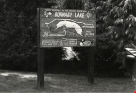
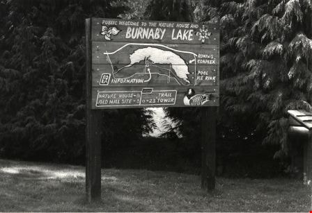
- Photograph shows the sign in front of the nature house in Burnaby Lake showing the locations of the Nature House, the Old Mill Site, the Rowing Complex, the pool, the ice rink and the trail.
- Repository
- City of Burnaby Archives
- Date
- September, 1976
- Collection/Fonds
- Burnaby Public Library Contemporary Visual Archive Project
- Physical Description
- 1 photograph : b&w ; 11 x 16 cm mounted on cardboard
- Description Level
- Item
- Record No.
- 556-478
- Access Restriction
- No restrictions
- Reproduction Restriction
- Reproduce for fair dealing purposes only
- Accession Number
- 2013-13
- Scope and Content
- Photograph shows the sign in front of the nature house in Burnaby Lake showing the locations of the Nature House, the Old Mill Site, the Rowing Complex, the pool, the ice rink and the trail.
- Media Type
- Photograph
- Photographer
- Salmon, Stu
- Notes
- Scope note taken directly from BPL photograph description.
- 1 b&w copy negative : 10 x 12.5 cm accompanying
- Geographic Access
- Burnaby Lake
- Historic Neighbourhood
- Burnaby Lake (Historic Neighbourhood)
Images

Cattle at Canada Way
https://search.heritageburnaby.ca/link/archivedescription36524
- Repository
- City of Burnaby Archives
- Date
- 1977
- Collection/Fonds
- Burnaby Historical Society fonds
- Description Level
- Item
- Physical Description
- 1 photograph : col. ; 9 x 8.5 cm
- Scope and Content
- Photograph of cattle grazing on the grass, taken from Burris Street, looking towards Canada Way.
- Repository
- City of Burnaby Archives
- Date
- 1977
- Collection/Fonds
- Burnaby Historical Society fonds
- Subseries
- Lubbock family subseries
- Physical Description
- 1 photograph : col. ; 9 x 8.5 cm
- Description Level
- Item
- Record No.
- 289-013
- Access Restriction
- No restrictions
- Reproduction Restriction
- Reproduce for fair dealing purposes only
- Accession Number
- BHS1992-24
- Scope and Content
- Photograph of cattle grazing on the grass, taken from Burris Street, looking towards Canada Way.
- Subjects
- Animals - Cows
- Media Type
- Photograph
- Notes
- Title based on contents of photograph
- Geographic Access
- Canada Way
- Burris Street
- Historic Neighbourhood
- Burnaby Lake (Historic Neighbourhood)
- Planning Study Area
- Morley-Buckingham Area
Images


Construction Sign
https://search.heritageburnaby.ca/link/archivedescription79447
- Repository
- City of Burnaby Archives
- Date
- September 24, 1976
- Collection/Fonds
- Burnaby Public Library Contemporary Visual Archive Project
- Description Level
- Item
- Physical Description
- 1 photograph : b&w ; 11 x 16 cm mounted on cardboard
- Scope and Content
- Photograph shows an "obstruction ahead" sign put down by BC Hydro crew, who can be seen working in the background, near Sperling and Canada Way.
- Repository
- City of Burnaby Archives
- Date
- September 24, 1976
- Collection/Fonds
- Burnaby Public Library Contemporary Visual Archive Project
- Physical Description
- 1 photograph : b&w ; 11 x 16 cm mounted on cardboard
- Description Level
- Item
- Record No.
- 556-299
- Access Restriction
- No restrictions
- Reproduction Restriction
- Reproduce for fair dealing purposes only
- Accession Number
- 2013-13
- Scope and Content
- Photograph shows an "obstruction ahead" sign put down by BC Hydro crew, who can be seen working in the background, near Sperling and Canada Way.
- Media Type
- Photograph
- Photographer
- Born, A. J.
- Notes
- Scope note taken directly from BPL photograph description.
- 1 b&w copy negative : 10 x 12.5 cm accompanying
- Geographic Access
- Sperling Avenue
- Canada Way
- Historic Neighbourhood
- Burnaby Lake (Historic Neighbourhood)
- Planning Study Area
- Morley-Buckingham Area
Images


Grazing cattle
https://search.heritageburnaby.ca/link/archivedescription36525
- Repository
- City of Burnaby Archives
- Date
- November 1978
- Collection/Fonds
- Burnaby Historical Society fonds
- Description Level
- Item
- Physical Description
- 1 photograph : col. ; 9 x 8.5 cm
- Scope and Content
- Photograph of cattle grazing on grass in a field between Canada Way and Burris Street.
- Repository
- City of Burnaby Archives
- Date
- November 1978
- Collection/Fonds
- Burnaby Historical Society fonds
- Subseries
- Lubbock family subseries
- Physical Description
- 1 photograph : col. ; 9 x 8.5 cm
- Description Level
- Item
- Record No.
- 289-014
- Access Restriction
- No restrictions
- Reproduction Restriction
- Reproduce for fair dealing purposes only
- Accession Number
- BHS1992-24
- Scope and Content
- Photograph of cattle grazing on grass in a field between Canada Way and Burris Street.
- Subjects
- Animals - Cows
- Media Type
- Photograph
- Notes
- Title based on contents of photograph
- Geographic Access
- Canada Way
- Grandview Highway
- Burris Street
- Historic Neighbourhood
- Burnaby Lake (Historic Neighbourhood)
- Planning Study Area
- Morley-Buckingham Area
Images

![Lubbock family home and farm, [197-] (date of original), copied 1986 thumbnail](/media/hpo/_Data/_Archives_Images/_Unrestricted/204/204-721.jpg?width=280)
Lubbock family home and farm
https://search.heritageburnaby.ca/link/archivedescription35862
- Repository
- City of Burnaby Archives
- Date
- [197-] (date of original), copied 1986
- Collection/Fonds
- Burnaby Historical Society fonds
- Description Level
- Item
- Physical Description
- 1 photograph : b&w ; 12.7 x 17.8 cm print
- Scope and Content
- Photograph of cows grazing on the Lubbock farm with the family home seen in the background. The house was built in 1898 by Edgar Sprott, brother of former Reeve, Charles F. Sprott. The Lubbock family moved into the house in 1915.
- Repository
- City of Burnaby Archives
- Date
- [197-] (date of original), copied 1986
- Collection/Fonds
- Burnaby Historical Society fonds
- Subseries
- Pioneer Tales subseries
- Physical Description
- 1 photograph : b&w ; 12.7 x 17.8 cm print
- Description Level
- Item
- Record No.
- 204-721
- Access Restriction
- No restrictions
- Reproduction Restriction
- Reproduce for fair dealing purposes only
- Accession Number
- BHS1988-03
- Scope and Content
- Photograph of cows grazing on the Lubbock farm with the family home seen in the background. The house was built in 1898 by Edgar Sprott, brother of former Reeve, Charles F. Sprott. The Lubbock family moved into the house in 1915.
- Media Type
- Photograph
- Notes
- Title based on contents of photograph.
- A note with this photograph indicated that the old street address of this property was 1 Arbor Lane.
- Geographic Access
- Grandview Highway
- Canada Way
- Burris Street
- Street Address
- 7803 Burris Street
- Historic Neighbourhood
- Burnaby Lake (Historic Neighbourhood)
- Planning Study Area
- Morley-Buckingham Area
Images
![Lubbock family home and farm, [197-] (date of original), copied 1986 thumbnail](/media/hpo/_Data/_Archives_Images/_Unrestricted/204/204-721.jpg)

Nature Trail Sign
https://search.heritageburnaby.ca/link/archivedescription79889
- Repository
- City of Burnaby Archives
- Date
- September 23, 1976
- Collection/Fonds
- Burnaby Public Library Contemporary Visual Archive Project
- Description Level
- Item
- Physical Description
- 1 photograph : b&w ; 11 x 16 cm mounted on cardboard
- Scope and Content
- Photograph shows a sign commemorating the creation of a nature trail at Burnaby Lake. The trail was developed by a Local Initiatives Project in 1973.
- Repository
- City of Burnaby Archives
- Date
- September 23, 1976
- Collection/Fonds
- Burnaby Public Library Contemporary Visual Archive Project
- Physical Description
- 1 photograph : b&w ; 11 x 16 cm mounted on cardboard
- Description Level
- Item
- Record No.
- 556-490
- Access Restriction
- No restrictions
- Reproduction Restriction
- Reproduce for fair dealing purposes only
- Accession Number
- 2013-13
- Scope and Content
- Photograph shows a sign commemorating the creation of a nature trail at Burnaby Lake. The trail was developed by a Local Initiatives Project in 1973.
- Media Type
- Photograph
- Photographer
- Norton, Paul
- Notes
- Scope note taken directly from BPL photograph description.
- 1 b&w copy negative : 10 x 12.5 cm accompanying
- Geographic Access
- Burnaby Lake
- Historic Neighbourhood
- Burnaby Lake (Historic Neighbourhood)
- Planning Study Area
- Burnaby Lake Area
Images

New homes on Burris Street
https://search.heritageburnaby.ca/link/archivedescription36523
- Repository
- City of Burnaby Archives
- Date
- 1977
- Collection/Fonds
- Burnaby Historical Society fonds
- Description Level
- Item
- Physical Description
- 1 photograph : col. ; 9 x 8.5 cm
- Scope and Content
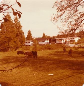
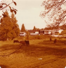
- Photograph of the "new area" of homes on Burris Street near the Lubbock farm. Cattle are visible grazing on grass in the middle-ground.
- Repository
- City of Burnaby Archives
- Date
- 1977
- Collection/Fonds
- Burnaby Historical Society fonds
- Subseries
- Lubbock family subseries
- Physical Description
- 1 photograph : col. ; 9 x 8.5 cm
- Description Level
- Item
- Record No.
- 289-012
- Access Restriction
- No restrictions
- Reproduction Restriction
- Reproduce for fair dealing purposes only
- Accession Number
- BHS1992-24
- Scope and Content
- Photograph of the "new area" of homes on Burris Street near the Lubbock farm. Cattle are visible grazing on grass in the middle-ground.
- Media Type
- Photograph
- Notes
- Title based on contents of photograph
- Geographic Access
- Burris Street
- Historic Neighbourhood
- Burnaby Lake (Historic Neighbourhood)
- Planning Study Area
- Morley-Buckingham Area
Images