Narrow Results By
Subject
- Buildings - Civic - Fire Halls 1
- Buildings - Civic - Libraries 2
- Buildings - Commercial - Automobile Dealerships 1
- Buildings - Commercial - Service Stations 2
- Buildings - Heritage 2
- Buildings - Industrial - Refineries 4
- Buildings - Religious - Churches 4
- Buildings - Residential - Houses 9
- Buildings - Schools 1
- Clothing - Costumes 1
- Clothing - Uniforms 1
- Events - Openings 1

Agnes & Elizabeth Michie Residence
https://search.heritageburnaby.ca/link/landmark554
- Repository
- Burnaby Heritage Planning
- Description
- Residential building.
- Associated Dates
- c.1935
- Street View URL
- Google Maps Street View
- Repository
- Burnaby Heritage Planning
- Geographic Access
- Yale Street
- Associated Dates
- c.1935
- Description
- Residential building.
- Heritage Value
- This interwar bungalow is beautifully preserved and retains many original features. Symmetrical in design, with two steeply-pitched front gables that flank a central arched gable over the front entrance, it also retains its narrow arched windows and projecting purlins in the front gables. Narrow sidelights flank the front door. The matching front elevation windows are typical of the period, with double-hung sash flanking a plate glass “picture window” with a curved transom; the upper panes are cross-leaded. This house was built by Agnes Michie and Elizabeth D. Michie.
- Locality
- Vancouver Heights
- Historic Neighbourhood
- Vancouver Heights (Historic Neighbourhood)
- Planning Study Area
- Burnaby Heights Area
- Ownership
- Private
- Street Address
- 3894 Yale Street
- Street View URL
- Google Maps Street View
Images


Isak & Lilly Gronning Residence
https://search.heritageburnaby.ca/link/landmark598
- Repository
- Burnaby Heritage Planning
- Description
- Residential building.
- Associated Dates
- c.1938
- Street View URL
- Google Maps Street View
- Repository
- Burnaby Heritage Planning
- Geographic Access
- Eton Street
- Associated Dates
- c.1938
- Description
- Residential building.
- Heritage Value
- This house was built for Isac Hartvig Peterson “Harry” Gronning (1880-1955), a Norwegian-born butcher, and his wife Lilly Geneva (née Hatton, 1889-1978). The Gronnings married in Vancouver in 1913, and lived in this home until at least Harry’s death in 1955. Designed to simulate a Norman-style cottage, the most distinctive feature of this eclectic bungalow is its round entry tower with a conical roof. Other distinctive features include its rolled roof edges that simulate a thatched roof, and its rounded arch windows surrounded with imitation voussoirs. It retains its original wooden-sash windows with leaded panes.
- Locality
- Vancouver Heights
- Historic Neighbourhood
- Vancouver Heights (Historic Neighbourhood)
- Planning Study Area
- Burnaby Heights Area
- Area
- 566.71
- Contributing Resource
- Building
- Ownership
- Private
- Street Address
- 3766 Eton Street
- Street View URL
- Google Maps Street View
Images


Mary Sutcliffe Residence
https://search.heritageburnaby.ca/link/landmark621
- Repository
- Burnaby Heritage Planning
- Description
- Residential building.
- Associated Dates
- c.1930
- Street View URL
- Google Maps Street View
- Repository
- Burnaby Heritage Planning
- Geographic Access
- Boundary Road North
- Associated Dates
- c.1930
- Description
- Residential building.
- Heritage Value
- Built at a time when historical styles were favoured for domestic construction, this charming cottage residence was built for Mary Seymour Sutcliffe (1870-1959), the wife of retired painter Arthur Sutcliffe (1863-1932). It was inspired by the British Arts and Crafts movement, as displayed in the half-timbering, rounded door hood and the picturesque, jerkin-headed roof with exposed purlins. While this house has a Boundary Road address, the house faces north instead of west, facing an elevated and extraordinary view of Burrard Inlet.
- Locality
- Vancouver Heights
- Historic Neighbourhood
- Vancouver Heights (Historic Neighbourhood)
- Planning Study Area
- Burnaby Heights Area
- Area
- 566.71
- Contributing Resource
- Building
- Ownership
- Private
- Street Address
- 650 Boundary Road North
- Street View URL
- Google Maps Street View
Images


Vancouver Heights Neighbourhood
https://search.heritageburnaby.ca/link/landmark666
- Repository
- Burnaby Heritage Planning
- Associated Dates
- 1925-1954
- Heritage Value
- Vancouver Heights remained an important residential and commercial centre in Burnaby throughout the 1925-1954 period. The area had its own Board of Trade and the North Burnaby Library was created to serve the residents. In 1949, the Hastings streetcars stopped running, but the area retained its reputation as one of the best shopping districts in the city.
- Historic Neighbourhood
- Vancouver Heights (Historic Neighbourhood)
- Planning Study Area
- Burnaby Heights Area
Images


Crabtown
https://search.heritageburnaby.ca/link/landmark674
- Repository
- Burnaby Heritage Planning
- Associated Dates
- 1912-1957
- Heritage Value
- North Burnaby's waterfront was the location of a unique squatter's community known as Crabtown. Although its origins are obscure, it is believed that the first shacks were built before 1912. When the depression of 1913-1917 began, the shacks became permanent homes for impoverished workers. During the Great Depression of the 1930s, the community grew larger. Crabtown was not a slum, but a neighbourhood - the community even rallied together to build a water supply system and trails up the steep bluff with steps and banisters so children could go to school safely. In 1957, the National Harbours Board decided that Crabtown was encroaching on Federal property and evicted all 130 residents. Within a few months, residents were relocated and 114 homes were levelled.
- Historic Neighbourhood
- Vancouver Heights (Historic Neighbourhood)
- Planning Study Area
- Burnaby Heights Area
Images

Interview with Edward Apps by Rod Fowler February 22, 1990 - Track 2
https://search.heritageburnaby.ca/link/oralhistory456
- Repository
- City of Burnaby Archives
- Date Range
- 1918-1950
- Length
- 00:05:30
- Summary
- This portion of the interview is about Ed Apps’ brief overview of the changes in Burnaby since he arrived in 1946, where he grew up in England, his war service, and the reasons that he and his wife Margaret immigrated to Canada from England
- Repository
- City of Burnaby Archives
- Summary
- This portion of the interview is about Ed Apps’ brief overview of the changes in Burnaby since he arrived in 1946, where he grew up in England, his war service, and the reasons that he and his wife Margaret immigrated to Canada from England
- Date Range
- 1918-1950
- Length
- 00:05:30
- Subjects
- Migration
- Historic Neighbourhood
- Vancouver Heights (Historic Neighbourhood)
- Planning Study Area
- Burnaby Heights Area
- Interviewer
- Fowler, Rod
- Interview Date
- February 22, 1990
- Scope and Content
- Recording is of an interview with Edward Apps, conducted by Rod Fowler. Ed Apps was one of eleven participants interviewed as part of the SFU/Burnaby Centennial Committee's oral history series titled, "Voices of Burnaby". The interview is mainly about Ed Apps involvement in community groups, particularly his work in seniors organizations lobbying for seniors’ housing since his retirement, and views about the role of Rate Payer groups, unions and politics in the development of North and South Burnaby. He also talks about his origin in England, his war service, arrival with his wife Margaret in Burnaby in 1946, his work with the Burnaby School Board and for the local union, the location of some of the older schools, the history of his house, and briefly about his wife and children. To view “Narrow By” terms for each track expand this description and see “Notes”.
- Biographical Notes
- Edward Apps was born in 1918 in London, England, and grew up in Kent and Essex. In WWII he flew the third glider to land in Normandy on June 6th, 1944. He and his wife Margaret Hope (1915-1985) immigrated to British Columbia in 1946, joining his wife’s parents, who had immigrated earlier in 1939, in Burnaby Heights in North Burnaby. He worked for the Burnaby School Board as Foreman Painter, and served on CUPE Local 379 Executive, until his retirement in 1982. In 1948 Ed Apps bought his first lot, for $150.00, in the 4700 block on Georgia Street, building houses there and in the 4100 block before buying his present home, a ca.1900 farm building, in the same area in 1954. North Burnaby was “bush country and orchards” in the 1950s; his two sons played in the ravines; and the family used the tram system on Hastings and Boundary Road for transportation. Development of municipal services seemed slower in North than South Burnaby, and Ed Apps remembers the strong role Rate Payers groups had in creating local services and lobbying Municipal Council for provide services. After retirement Ed Apps became involved in several local and provincial seniors organizations, advocating for better housing, including serving on the Executives of the Network of Burnaby Seniors and the Council of Senior Citizens Organization, and was active in the provincial Seniors Research and Resource and CMHC Housing Committee. He also served on the Centennial Committee of Burnaby.
- Total Tracks
- 8
- Total Length
- 0:56:50
- Interviewee Name
- Apps, Ed
- Interviewer Bio
- Rod Fowler returned to university as a mature student in the 1980s after working about twenty years in the field of economics and computerization in business in England, Europe and Western Canada. He graduated with a BA from SFU in both History and Sociology in 1987, his MA degree in Geography in 1989, and his PhD in Cultural Geography at SFU. He taught courses in Geography, Sociology, History and Canadian Studies at several Lower Mainland colleges, before becoming a full time member of the Geography Department at Kwantlen University College.
- Collection/Fonds
- SFU/Burnaby Centennial Committee fonds
- Transcript Available
- Transcript available
- Media Type
- Sound Recording
- Web Notes
- Interviews were digitized in 2015 allowing them to be accessible on Heritage Burnaby. The digitization project was initiated by the Community Heritage Commission with support from City of Burnaby Council.
Audio Tracks
Track two of interview with Ed Apps
Track two of interview with Ed Apps
https://search.heritageburnaby.ca/media/hpo/_Data/_Archives_Oral_Histories/_Unrestricted/MSS187-015/MSS187-015_Track_2.mp3![Homes in Vancouver Heights, [between 1925 and 1930] thumbnail](/media/hpo/_Data/_Archives_Images/_Unrestricted/371/476-006.jpg?width=280)
Homes in Vancouver Heights
https://search.heritageburnaby.ca/link/archivedescription38663
- Repository
- City of Burnaby Archives
- Date
- [between 1925 and 1930]
- Collection/Fonds
- Burnaby Historical Society fonds
- Description Level
- Item
- Physical Description
- 1 photograph : sepia ; 14.5 x 20.5 cm
- Scope and Content
- Photograph of a row of unidentified houses in the Vancouver Heights area.
- Repository
- City of Burnaby Archives
- Date
- [between 1925 and 1930]
- Collection/Fonds
- Burnaby Historical Society fonds
- Subseries
- North Burnaby Board of Trade subseries
- Physical Description
- 1 photograph : sepia ; 14.5 x 20.5 cm
- Description Level
- Item
- Record No.
- 476-006
- Access Restriction
- No restrictions
- Reproduction Restriction
- No known restrictions
- Accession Number
- BHS2005-8
- Scope and Content
- Photograph of a row of unidentified houses in the Vancouver Heights area.
- Subjects
- Buildings - Residential - Houses
- Media Type
- Photograph
- Notes
- Title based on contents of photograph.
- Historic Neighbourhood
- Vancouver Heights (Historic Neighbourhood)
- Planning Study Area
- Burnaby Heights Area
Images
![Homes in Vancouver Heights, [between 1925 and 1930] thumbnail](/media/hpo/_Data/_Archives_Images/_Unrestricted/371/476-006.jpg)
Houses in Vancouver Heights
https://search.heritageburnaby.ca/link/archivedescription38664
- Repository
- City of Burnaby Archives
- Date
- [between 1925 and 1930]
- Collection/Fonds
- Burnaby Historical Society fonds
- Description Level
- Item
- Physical Description
- 1 photograph : sepia ; 14.7 x 20.5 cm
- Scope and Content
- Photograph taken looking east along Dundas Street with 3738 Dundas Street the first home visible. A gravel sidewalk runs along the front of the homes.
- Repository
- City of Burnaby Archives
- Date
- [between 1925 and 1930]
- Collection/Fonds
- Burnaby Historical Society fonds
- Subseries
- North Burnaby Board of Trade subseries
- Physical Description
- 1 photograph : sepia ; 14.7 x 20.5 cm
- Description Level
- Item
- Record No.
- 476-007
- Access Restriction
- No restrictions
- Reproduction Restriction
- No known restrictions
- Accession Number
- BHS2005-8
- Scope and Content
- Photograph taken looking east along Dundas Street with 3738 Dundas Street the first home visible. A gravel sidewalk runs along the front of the homes.
- Subjects
- Buildings - Residential - Houses
- Media Type
- Photograph
- Notes
- Title based on contents of photograph
- Geographic Access
- Dundas Street
- Street Address
- 3738 Dundas Street
- Historic Neighbourhood
- Vancouver Heights (Historic Neighbourhood)
- Planning Study Area
- Burnaby Heights Area
Images
![St. Nicolas Church, [between 1925 and 1930] thumbnail](/media/hpo/_Data/_Archives_Images/_Unrestricted/371/476-009.jpg?width=280)
St. Nicolas Church
https://search.heritageburnaby.ca/link/archivedescription38666
- Repository
- City of Burnaby Archives
- Date
- [between 1925 and 1930]
- Collection/Fonds
- Burnaby Historical Society fonds
- Description Level
- Item
- Physical Description
- 1 photograph : b&w ; 19.5 x 24.5 cm
- Scope and Content
- Photograph of the interior of St. Nicholas Anglican Church, at the corner of Triumph Street and Ingleton Avenue.
- Repository
- City of Burnaby Archives
- Date
- [between 1925 and 1930]
- Collection/Fonds
- Burnaby Historical Society fonds
- Subseries
- North Burnaby Board of Trade subseries
- Physical Description
- 1 photograph : b&w ; 19.5 x 24.5 cm
- Description Level
- Item
- Record No.
- 476-009
- Access Restriction
- No restrictions
- Reproduction Restriction
- No known restrictions
- Accession Number
- BHS2005-8
- Scope and Content
- Photograph of the interior of St. Nicholas Anglican Church, at the corner of Triumph Street and Ingleton Avenue.
- Subjects
- Buildings - Religious - Churches
- Media Type
- Photograph
- Photographer
- Charlton and Rathburn
- Notes
- Title based on contents of photograph
- Church alternate spelling: "St Nicholas Anglican Church"
- Geographic Access
- Ingleton Avenue
- Triumph Street
- Street Address
- 3883 Triumph Street
- Historic Neighbourhood
- Vancouver Heights (Historic Neighbourhood)
- Planning Study Area
- Burnaby Heights Area
Images
![St. Nicolas Church, [between 1925 and 1930] thumbnail](/media/hpo/_Data/_Archives_Images/_Unrestricted/371/476-009.jpg)
Interview with Annie Boulanger by Rod Fowler April 9, 1990 - Track 6
https://search.heritageburnaby.ca/link/oralhistory488
- Repository
- City of Burnaby Archives
- Date Range
- 1925-1970
- Length
- 00:07:42
- Summary
- This portion of the interview is about Annie Boulanger’s family history, her parents’ origin, work and move to Burnaby, what the Napier Street area looked like in the 1950s and the Government Street neighbourhood in the 1960s, her education and teaching career, and her marriage. She explains why Go…
- Repository
- City of Burnaby Archives
- Summary
- This portion of the interview is about Annie Boulanger’s family history, her parents’ origin, work and move to Burnaby, what the Napier Street area looked like in the 1950s and the Government Street neighbourhood in the 1960s, her education and teaching career, and her marriage. She explains why Government Street has a jog in it at Brighton.
- Date Range
- 1925-1970
- Length
- 00:07:42
- Subjects
- Occupations - Teachers
- Historic Neighbourhood
- Vancouver Heights (Historic Neighbourhood)
- Lozells (Historic Neighbourhood)
- Planning Study Area
- Burnaby Heights Area
- Government Road Area
- Interviewer
- Fowler, Rod
- Interview Date
- April 9, 1990
- Scope and Content
- Recording is of an interview with Annie Boulanger, conducted by Rod Fowler. Annie Boulanger was one of eleven participants interviewed as part of the SFU/Burnaby Centennial Committee's oral history series titled, "Voices of Burnaby". The interview is mainly about Annie Boulanger’s volunteer community work in Burnaby, including initiating the teaching of french and gymnastics at Seaforth School where her children attended, doing historical research and oral histories for Burnaby Heritage Village and the SFU Archives, becoming a long term member of the Burnaby Writers’ Club, being a member and President of Burnaby Arts Council, and member of the Parks Board's Centre for the Performing Arts Committee (1987). The interview focuses attention on the Arts Council’s financial difficulties between 1985 and 1990, and the need for a comprehensive approach to supporting the arts through a municipal arts policy. Annie Boulanger also talks about her parents’ history, their home on Napier Street and her later home on Government Road, her education and teaching career, and her arts journalism. To view “Narrow By” terms for each track expand this description and see “Notes”.
- Biographical Notes
- Annie Urbanovits Boulanger’s parents emigrated from Hungary to Toronto, Louis in 1925 and Irene in 1930, where they married. Louis and Irene Boulanger moved to Vancouver where Louis worked in the Vancouver Shipyards during WWII and then for Nichols Chemical Company in Barnet for 15 years. While the Urbanovits family lived in Cloverdale, Louis commuted to Kask’s Camp in Barnet, until they moved to Burnaby in 1951 to an old farm purchased on Napier Street. Between 1951 and 1956 Annie completed her BA degree, majoring in chemistry and english with a minor in physical education, and obtained her teaching diploma at UBC. She taught for 4 years in various locations in BC before marrying and moving to Manitoba and Ottawa. She and her husband and five children (two more children to come later) returned to Burnaby in 1964 to a home on Government Street to be close to family. Annie Boulanger became involved in the community first through her children’s school, initiating and teaching french classes in Seaforth School in 1969, and supporting the development of gymnastics in school and as a municipal program. Her interest in Archives lead to doing oral histories for John Adams, curator of Heritage Village [Burnaby Heritage Village], and for SFU Archives. She became a long time member of the Burnaby Writers’ Club in the 1970s, taking a course in writing non-fiction from Chris Potter. In 1983 Annie Boulanger joined the Burnaby Arts Council, becoming President in 1985. She was involved in lobbying the municipality for better monetary support and facilities for the arts and for the creation of a Municipal Arts Policy. She has continued to promote the arts in Burnaby through her appointment to Burnaby’s Visual Arts Advisory Board in 1997, her arts journalism, writing regular book and theatre reviews for the local newspaper, and other activities. She was a member of the Burnaby Centennial Committee and was one of the editors of the book “Burnaby Centennial Anthology”.
- Total Tracks
- 8
- Total Length
- 0:41:53
- Interviewee Name
- Boulanger, Annie
- Interviewer Bio
- Rod Fowler returned to university as a mature student in the 1980s after working about twenty years in the field of economics and computerization in business in England, Europe and Western Canada. He graduated with a BA from SFU in both History and Sociology in 1987, his MA degree in Geography in 1989, and his PhD in Cultural Geography at SFU. He taught courses in Geography, Sociology, History and Canadian Studies at several Lower Mainland colleges, before becoming a full time member of the Geography Department at Kwantlen University College.
- Collection/Fonds
- SFU/Burnaby Centennial Committee fonds
- Transcript Available
- Transcript available
- Media Type
- Sound Recording
- Web Notes
- Interviews were digitized in 2015 allowing them to be accessible on Heritage Burnaby. The digitization project was initiated by the Community Heritage Commission with support from City of Burnaby Council.
Audio Tracks
Track six of interview with Annie Boulanger
Track six of interview with Annie Boulanger
https://search.heritageburnaby.ca/media/hpo/_Data/_Archives_Oral_Histories/_Unrestricted/MSS187-022/MSS187-022_Track_6.mp3Fire insurance plans - Greater Vancouver - Volume XV - Municipality of Burnaby
https://search.heritageburnaby.ca/link/museumdescription17795
- Repository
- Burnaby Village Museum
- Date
- 1927-1940
- Collection/Fonds
- Burnaby Village Museum Map collection
- Description Level
- Item
- Physical Description
- 11 plans on 8 sheets : col. lithographic print ; 64 x 54 cm
- Scope and Content
- Item consists of fire insurance plans titled "Greater Vancouver / Volume XV / Municipality / of Burnaby" surveyed May 1927 and revised October 1940. Volume XV includes a two page Key Plan (A and B) identifying associated plan numbers and district lots and nine numbered fire insurance plans identifi…
- Repository
- Burnaby Village Museum
- Collection/Fonds
- Burnaby Village Museum Map collection
- Description Level
- Item
- Physical Description
- 11 plans on 8 sheets : col. lithographic print ; 64 x 54 cm
- Material Details
- Scales between [1:600] and [1:6000]
- Scope and Content
- Item consists of fire insurance plans titled "Greater Vancouver / Volume XV / Municipality / of Burnaby" surveyed May 1927 and revised October 1940. Volume XV includes a two page Key Plan (A and B) identifying associated plan numbers and district lots and nine numbered fire insurance plans identified as; 1507; 1508 ; 1517; 1518; 1519; 1520;1521; 1531and 1532.
- Publisher
- Plan Department of Fire Branch of British Columbia Underwriters' Association
- Accession Code
- BV987.1.70
- Access Restriction
- No restrictions
- Reproduction Restriction
- May be restricted by third party rights
- Date
- 1927-1940
- Media Type
- Cartographic Material
- Historic Neighbourhood
- Vancouver Heights (Historic Neighbourhood)
- Planning Study Area
- Burnaby Heights Area
- Willingdon Heights Area
- Scan Resolution
- 400
- Notes
- Title based on contents of item
- These plans are contained within a bound book with labels on cover page reading: "Plan No. 90 / THIS INSURANCE PLAN / of / Vancouver VOLUME "8" / IN THE PROPERTY OF THE / British Columbia Insurance Underwriter's Association / Vancouver B.C. / AND IS LOANED / MELVILLE F. THOMSON CO. .../ Date May 26th, 1934"; / "Plan No. 74 / THIS INSURANCE PLAN / OF / VANCOUVER VOLUME "9"" / Plan No. 11 / THIS INSURANCE PLAN / OF / BURNABY VOLUMES 15-19" / "THIS PLAN IS THE PROPERTY OF / THE / BRITISH LAW INSURANCE COMPANY / LIMITED"
- Fire insurance plans cover various district lots in Burnaby including: District Lot 116,121, 186 and 187.
- Sticker adhered to Key Plan B reads: "
- Contact Burnaby Village Museum to view fire insurance plans that are part of Volume XV
![Don Carpenter, [1929 or 1930] (date of original), copied 1991 thumbnail](/media/hpo/_Data/_Archives_Images/_Unrestricted/370/370-138.jpg?width=280)
Don Carpenter
https://search.heritageburnaby.ca/link/archivedescription37550
- Repository
- City of Burnaby Archives
- Date
- [1929 or 1930] (date of original), copied 1991
- Collection/Fonds
- Burnaby Historical Society fonds
- Description Level
- Item
- Physical Description
- 1 photograph : b&w ; 4.4 x 2.9 cm print on contact sheet 20.2 x 25.3 cm
- Scope and Content
- Photograph of Don Carpenter sitting on a wagon in the backyard of his 4000 block Cambridge Street home. The house in the background is on Trinity Avenue.
- Repository
- City of Burnaby Archives
- Date
- [1929 or 1930] (date of original), copied 1991
- Collection/Fonds
- Burnaby Historical Society fonds
- Subseries
- Burnaby Image Bank subseries
- Physical Description
- 1 photograph : b&w ; 4.4 x 2.9 cm print on contact sheet 20.2 x 25.3 cm
- Description Level
- Item
- Record No.
- 370-138
- Access Restriction
- No restrictions
- Reproduction Restriction
- No known restrictions
- Accession Number
- BHS1999-03
- Scope and Content
- Photograph of Don Carpenter sitting on a wagon in the backyard of his 4000 block Cambridge Street home. The house in the background is on Trinity Avenue.
- Subjects
- Transportation - Wagons
- Names
- Carpenter, Donald "Don"
- Media Type
- Photograph
- Notes
- Title based on contents of photograph
- 1 b&w copy negative accompanying
- Geographic Access
- Cambridge Street
- Historic Neighbourhood
- Vancouver Heights (Historic Neighbourhood)
- Planning Study Area
- Burnaby Heights Area
Images
![Don Carpenter, [1929 or 1930] (date of original), copied 1991 thumbnail](/media/hpo/_Data/_Archives_Images/_Unrestricted/370/370-138.jpg)
![Anderson family home, [1930] (date of original), copied 1986 thumbnail](/media/hpo/_Data/_Archives_Images/_Unrestricted/204/204-034.jpg?width=280)
Anderson family home
https://search.heritageburnaby.ca/link/archivedescription35177
- Repository
- City of Burnaby Archives
- Date
- [1930] (date of original), copied 1986
- Collection/Fonds
- Burnaby Historical Society fonds
- Description Level
- Item
- Physical Description
- 1 photograph : b&w ; 12.7 x 17.8 cm print
- Scope and Content
- Photograph of the Anderson family home at 4127 McGill Street in North Burnaby. The house was built ca. 1923.
- Repository
- City of Burnaby Archives
- Date
- [1930] (date of original), copied 1986
- Collection/Fonds
- Burnaby Historical Society fonds
- Subseries
- Pioneer Tales subseries
- Physical Description
- 1 photograph : b&w ; 12.7 x 17.8 cm print
- Description Level
- Item
- Record No.
- 204-034
- Access Restriction
- No restrictions
- Reproduction Restriction
- No known restrictions
- Accession Number
- BHS1988-03
- Scope and Content
- Photograph of the Anderson family home at 4127 McGill Street in North Burnaby. The house was built ca. 1923.
- Subjects
- Buildings - Residential - Houses
- Media Type
- Photograph
- Notes
- Title based on contents of photograph
- Geographic Access
- McGill Street
- Street Address
- 4127 McGill Street
- Historic Neighbourhood
- Vancouver Heights (Historic Neighbourhood)
- Planning Study Area
- Burnaby Heights Area
Images
![Anderson family home, [1930] (date of original), copied 1986 thumbnail](/media/hpo/_Data/_Archives_Images/_Unrestricted/204/204-034.jpg)
Cambell family home
https://search.heritageburnaby.ca/link/archivedescription35786
- Repository
- City of Burnaby Archives
- Date
- 1930 (date of original), copied 1986
- Collection/Fonds
- Burnaby Historical Society fonds
- Description Level
- Item
- Physical Description
- 1 photograph : b&w ; 12.7 x 17.8 cm print
- Scope and Content
- Photograph of the second Campbell family home at 4120 Eton Street. John Campbell, the family's father, and his friends built this larger house, and then razed the former one on the lot.
- Repository
- City of Burnaby Archives
- Date
- 1930 (date of original), copied 1986
- Collection/Fonds
- Burnaby Historical Society fonds
- Subseries
- Pioneer Tales subseries
- Physical Description
- 1 photograph : b&w ; 12.7 x 17.8 cm print
- Description Level
- Item
- Record No.
- 204-644
- Access Restriction
- No restrictions
- Reproduction Restriction
- No known restrictions
- Accession Number
- BHS1988-03
- Scope and Content
- Photograph of the second Campbell family home at 4120 Eton Street. John Campbell, the family's father, and his friends built this larger house, and then razed the former one on the lot.
- Subjects
- Buildings - Residential - Houses
- Media Type
- Photograph
- Notes
- Title based on contents of photograph
- The former home on this lot is photo 204-643
- Geographic Access
- Eton Street
- Street Address
- 4120 Eton Street
- Historic Neighbourhood
- Vancouver Heights (Historic Neighbourhood)
- Planning Study Area
- Burnaby Heights Area
Images

![Overlynn, [1930] thumbnail](/media/hpo/_Data/_Archives_Images/_Unrestricted/251/301-001.jpg?width=280)
Overlynn
https://search.heritageburnaby.ca/link/archivedescription36577
- Repository
- City of Burnaby Archives
- Date
- [1930]
- Collection/Fonds
- Burnaby Historical Society fonds
- Description Level
- Item
- Physical Description
- 1 photograph : hand-tinted col. ; 9.5 x 14.5 cm print
- Scope and Content
- Photograph of the exterior of Overlynn Mansion.
- Repository
- City of Burnaby Archives
- Date
- [1930]
- Collection/Fonds
- Burnaby Historical Society fonds
- Subseries
- Action Line Housing Society subseries
- Physical Description
- 1 photograph : hand-tinted col. ; 9.5 x 14.5 cm print
- Description Level
- Item
- Record No.
- 301-001
- Access Restriction
- No restrictions
- Reproduction Restriction
- No known restrictions
- Accession Number
- BHS1992-42
- Scope and Content
- Photograph of the exterior of Overlynn Mansion.
- Media Type
- Photograph
- Notes
- Title based on contents of photograph
- Geographic Access
- McGill Street
- Street Address
- 3755 McGill Street
- Historic Neighbourhood
- Vancouver Heights (Historic Neighbourhood)
- Planning Study Area
- Burnaby Heights Area
Images
![Overlynn, [1930] thumbnail](/media/hpo/_Data/_Archives_Images/_Unrestricted/251/301-001.jpg)
![Burnaby North High School Latin Club, [193-] (date of original), copied 1992 thumbnail](/media/hpo/_Data/_Archives_Images/_Unrestricted/315/315-073.jpg?width=280)
Burnaby North High School Latin Club
https://search.heritageburnaby.ca/link/archivedescription36718
- Repository
- City of Burnaby Archives
- Date
- [193-] (date of original), copied 1992
- Collection/Fonds
- Burnaby Historical Society fonds
- Description Level
- Item
- Physical Description
- 1 photograph : b&w ; 8.2 x 12.6 cm print
- Scope and Content
- Photograph of students in the Burnaby North High School Latin Club.
- Repository
- City of Burnaby Archives
- Date
- [193-] (date of original), copied 1992
- Collection/Fonds
- Burnaby Historical Society fonds
- Subseries
- Burnaby Centennial Anthology subseries
- Physical Description
- 1 photograph : b&w ; 8.2 x 12.6 cm print
- Description Level
- Item
- Record No.
- 315-073
- Access Restriction
- No restrictions
- Reproduction Restriction
- No known restrictions
- Accession Number
- BHS1994-04
- Scope and Content
- Photograph of students in the Burnaby North High School Latin Club.
- Subjects
- Organizations
- Media Type
- Photograph
- Notes
- Title based on contents of photograph
- Geographic Access
- Pandora Street
- Street Address
- 4375 Pandora Street
- Historic Neighbourhood
- Vancouver Heights (Historic Neighbourhood)
- Planning Study Area
- Burnaby Heights Area
Images
![Burnaby North High School Latin Club, [193-] (date of original), copied 1992 thumbnail](/media/hpo/_Data/_Archives_Images/_Unrestricted/315/315-073.jpg)
![Burnaby North High School Teachers, [193-] (date of original), copied 1992 thumbnail](/media/hpo/_Data/_Archives_Images/_Unrestricted/315/315-074.jpg?width=280)
Burnaby North High School Teachers
https://search.heritageburnaby.ca/link/archivedescription36719
- Repository
- City of Burnaby Archives
- Date
- [193-] (date of original), copied 1992
- Collection/Fonds
- Burnaby Historical Society fonds
- Description Level
- Item
- Physical Description
- 1 photograph : b&w ; 8.0 x 12.6 cm print
- Scope and Content
- Photograph of Burnaby North High School Teachers. Top row, left to right: Mr. McFadden, Mr. MacLean, Mr. Cameron, and Mr. Stuart Burton. Front row, left to right: Mrs. Spencer, Mr. George B. Carpenter, and Miss Mary Buxton.
- Repository
- City of Burnaby Archives
- Date
- [193-] (date of original), copied 1992
- Collection/Fonds
- Burnaby Historical Society fonds
- Subseries
- Burnaby Centennial Anthology subseries
- Physical Description
- 1 photograph : b&w ; 8.0 x 12.6 cm print
- Description Level
- Item
- Record No.
- 315-074
- Access Restriction
- No restrictions
- Reproduction Restriction
- No known restrictions
- Accession Number
- BHS1994-04
- Scope and Content
- Photograph of Burnaby North High School Teachers. Top row, left to right: Mr. McFadden, Mr. MacLean, Mr. Cameron, and Mr. Stuart Burton. Front row, left to right: Mrs. Spencer, Mr. George B. Carpenter, and Miss Mary Buxton.
- Subjects
- Occupations - Teachers
- Media Type
- Photograph
- Notes
- Title based on contents of photograph
- Geographic Access
- Pandora Street
- Street Address
- 4375 Pandora Street
- Historic Neighbourhood
- Vancouver Heights (Historic Neighbourhood)
- Planning Study Area
- Burnaby Heights Area
Images
![Burnaby North High School Teachers, [193-] (date of original), copied 1992 thumbnail](/media/hpo/_Data/_Archives_Images/_Unrestricted/315/315-074.jpg)
![Mr. and Mrs. Stark, [193-?] (date of original), copied 1992 thumbnail](/media/hpo/_Data/_Archives_Images/_Unrestricted/315/315-482.jpg?width=280)
Mr. and Mrs. Stark
https://search.heritageburnaby.ca/link/archivedescription37019
- Repository
- City of Burnaby Archives
- Date
- [193-?] (date of original), copied 1992
- Collection/Fonds
- Burnaby Historical Society fonds
- Description Level
- Item
- Physical Description
- 1 photograph : b&w ; 8.1 x 12.5 cm print
- Scope and Content
- Photograph of Mr. and Mrs. Stark in front of their home on the 3900 block of Albert Street.
- Repository
- City of Burnaby Archives
- Date
- [193-?] (date of original), copied 1992
- Collection/Fonds
- Burnaby Historical Society fonds
- Subseries
- Burnaby Centennial Anthology subseries
- Physical Description
- 1 photograph : b&w ; 8.1 x 12.5 cm print
- Description Level
- Item
- Record No.
- 315-482
- Access Restriction
- No restrictions
- Reproduction Restriction
- No known restrictions
- Accession Number
- BHS1994-04
- Scope and Content
- Photograph of Mr. and Mrs. Stark in front of their home on the 3900 block of Albert Street.
- Media Type
- Photograph
- Notes
- Title based on contents of photograph
- Geographic Access
- Albert Street
- Historic Neighbourhood
- Vancouver Heights (Historic Neighbourhood)
- Planning Study Area
- Burnaby Heights Area
Images
![Mr. and Mrs. Stark, [193-?] (date of original), copied 1992 thumbnail](/media/hpo/_Data/_Archives_Images/_Unrestricted/315/315-482.jpg)
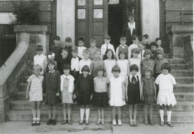
Gilmore Avenue School Grade 1 Class
https://search.heritageburnaby.ca/link/archivedescription37531
- Repository
- City of Burnaby Archives
- Date
- 1930 (date of original), copied 1991
- Collection/Fonds
- Burnaby Historical Society fonds
- Description Level
- Item
- Physical Description
- 1 photograph : b&w ; 3.4 x 4.4 cm print on contact sheet 20.2 x 25.3 cm
- Scope and Content
- Photograph of a Gilmore School Grade 1 class. The teacher is Miss Gower.
- Repository
- City of Burnaby Archives
- Date
- 1930 (date of original), copied 1991
- Collection/Fonds
- Burnaby Historical Society fonds
- Subseries
- Burnaby Image Bank subseries
- Physical Description
- 1 photograph : b&w ; 3.4 x 4.4 cm print on contact sheet 20.2 x 25.3 cm
- Description Level
- Item
- Record No.
- 370-119
- Access Restriction
- No restrictions
- Reproduction Restriction
- No known restrictions
- Accession Number
- BHS1999-03
- Scope and Content
- Photograph of a Gilmore School Grade 1 class. The teacher is Miss Gower.
- Subjects
- Occupations - Teachers
- Names
- Gilmore Avenue School
- Media Type
- Photograph
- Notes
- Title based on contents of photograph
- 1 b&w copy negative accompanying
- Geographic Access
- Gilmore Avenue
- Street Address
- 50 Gilmore Avenue
- Historic Neighbourhood
- Vancouver Heights (Historic Neighbourhood)
- Planning Study Area
- Burnaby Heights Area
Images

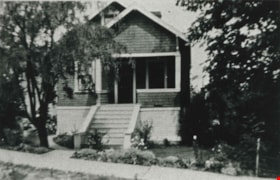
![3700 Block Yale Street, [between 1930 and 1934] (date of original), copied 1991 thumbnail](/media/hpo/_Data/_Archives_Images/_Unrestricted/370/370-139.jpg?width=280)
3700 Block Yale Street
https://search.heritageburnaby.ca/link/archivedescription37551
- Repository
- City of Burnaby Archives
- Date
- [between 1930 and 1934] (date of original), copied 1991
- Collection/Fonds
- Burnaby Historical Society fonds
- Description Level
- Item
- Physical Description
- 1 photograph : b&w ; 2.8 x 4.8 cm print on contact sheet 20.2 x 25.3 cm
- Scope and Content
- Photograph of the 3700 block of Yale Street. At the left is a side view of 515 Esmond Avenue North.
- Repository
- City of Burnaby Archives
- Date
- [between 1930 and 1934] (date of original), copied 1991
- Collection/Fonds
- Burnaby Historical Society fonds
- Subseries
- Burnaby Image Bank subseries
- Physical Description
- 1 photograph : b&w ; 2.8 x 4.8 cm print on contact sheet 20.2 x 25.3 cm
- Description Level
- Item
- Record No.
- 370-139
- Access Restriction
- No restrictions
- Reproduction Restriction
- No known restrictions
- Accession Number
- BHS1999-03
- Scope and Content
- Photograph of the 3700 block of Yale Street. At the left is a side view of 515 Esmond Avenue North.
- Subjects
- Geographic Features - Gardens
- Media Type
- Photograph
- Notes
- Title based on contents of photograph
- 1 b&w copy negative accompanying
- Geographic Access
- Yale Street
- Historic Neighbourhood
- Vancouver Heights (Historic Neighbourhood)
- Planning Study Area
- Burnaby Heights Area
Images
![3700 Block Yale Street, [between 1930 and 1934] (date of original), copied 1991 thumbnail](/media/hpo/_Data/_Archives_Images/_Unrestricted/370/370-139.jpg)