Narrow Results By

Isak & Lilly Gronning Residence
https://search.heritageburnaby.ca/link/landmark598
- Repository
- Burnaby Heritage Planning
- Description
- Residential building.
- Associated Dates
- c.1938
- Street View URL
- Google Maps Street View
- Repository
- Burnaby Heritage Planning
- Geographic Access
- Eton Street
- Associated Dates
- c.1938
- Description
- Residential building.
- Heritage Value
- This house was built for Isac Hartvig Peterson “Harry” Gronning (1880-1955), a Norwegian-born butcher, and his wife Lilly Geneva (née Hatton, 1889-1978). The Gronnings married in Vancouver in 1913, and lived in this home until at least Harry’s death in 1955. Designed to simulate a Norman-style cottage, the most distinctive feature of this eclectic bungalow is its round entry tower with a conical roof. Other distinctive features include its rolled roof edges that simulate a thatched roof, and its rounded arch windows surrounded with imitation voussoirs. It retains its original wooden-sash windows with leaded panes.
- Locality
- Vancouver Heights
- Historic Neighbourhood
- Vancouver Heights (Historic Neighbourhood)
- Planning Study Area
- Burnaby Heights Area
- Area
- 566.71
- Contributing Resource
- Building
- Ownership
- Private
- Street Address
- 3766 Eton Street
- Street View URL
- Google Maps Street View
Images


Lewis & Millicent Physick Residence
https://search.heritageburnaby.ca/link/landmark616
- Repository
- Burnaby Heritage Planning
- Description
- Residential building.
- Associated Dates
- 1939
- Street View URL
- Google Maps Street View
- Repository
- Burnaby Heritage Planning
- Geographic Access
- Boundary Road North
- Associated Dates
- 1939
- Description
- Residential building.
- Heritage Value
- This modest residence was built for Lewis Baker Physick (1905-1971), a freight dispatcher for B.C. Motor Transport Company who later worked for B.C. Hydro, and Millicent Physick (née Edwards, 1894-1971), a hairdresser, who lived here until their respective deaths. Situated on a terraced lot with stone-clad retaining walls, this home was influenced by the British Arts and Crafts style, which remained popular throughout the 1930s. Such stylistic influence can be seen in the second floor overhang, which is supported by false beams, leaded casement windows and steeply pitched roof and front gable. The roofline is enhanced by a jerkin-headed roof on the front gable. Apart from the addition of a later south elevation extension, the house remains in excellent original condition. Located on an elevated site, this residence has an unobstructed view of downtown Vancouver and Burrard Inlet.
- Locality
- Vancouver Heights
- Historic Neighbourhood
- Vancouver Heights (Historic Neighbourhood)
- Planning Study Area
- Burnaby Heights Area
- Area
- 566.71
- Contributing Resource
- Building
- Ownership
- Private
- Street Address
- 420 Boundary Road North
- Street View URL
- Google Maps Street View
Images


Lucy Turner Residence
https://search.heritageburnaby.ca/link/landmark618
- Repository
- Burnaby Heritage Planning
- Description
- Residential building.
- Associated Dates
- 1930
- Street View URL
- Google Maps Street View
- Repository
- Burnaby Heritage Planning
- Geographic Access
- Boundary Road North
- Associated Dates
- 1930
- Description
- Residential building.
- Heritage Value
- This house was built for Lucy Lillian Turner (1881-1959), the daughter of Captain Andrew Jackson Cates of North Vancouver. Lucy Turner was the widow of Robert Ketchson Turner (1871-1918), who was a purser for her father’s Terminal Steam Navigation Company. They were married in 1913; Robert died during the 1918 Spanish Influenza epidemic and was buried at Mountain View Cemetery in Vancouver. Located on an elevated site, this residence boasts an unobstructed view of downtown Vancouver and Burrard Inlet and is situated amidst a context of homes of a similar age and scale. Demonstrating the late influence of the Craftsman style, this one and one-half storey house has triangular eave brackets and exposed rafter tails and purlins. A central wall dormer projects over the central front entry. Though the integrity of the house has been compromised with a later coat of stucco over the original siding, it maintains its double-hung wooden windows and original form, scale and massing.
- Locality
- Vancouver Heights
- Historic Neighbourhood
- Vancouver Heights (Historic Neighbourhood)
- Planning Study Area
- Burnaby Heights Area
- Area
- 566.71
- Contributing Resource
- Building
- Ownership
- Private
- Street Address
- 324 Boundary Road North
- Street View URL
- Google Maps Street View
Images


Mary Sutcliffe Residence
https://search.heritageburnaby.ca/link/landmark621
- Repository
- Burnaby Heritage Planning
- Description
- Residential building.
- Associated Dates
- c.1930
- Street View URL
- Google Maps Street View
- Repository
- Burnaby Heritage Planning
- Geographic Access
- Boundary Road North
- Associated Dates
- c.1930
- Description
- Residential building.
- Heritage Value
- Built at a time when historical styles were favoured for domestic construction, this charming cottage residence was built for Mary Seymour Sutcliffe (1870-1959), the wife of retired painter Arthur Sutcliffe (1863-1932). It was inspired by the British Arts and Crafts movement, as displayed in the half-timbering, rounded door hood and the picturesque, jerkin-headed roof with exposed purlins. While this house has a Boundary Road address, the house faces north instead of west, facing an elevated and extraordinary view of Burrard Inlet.
- Locality
- Vancouver Heights
- Historic Neighbourhood
- Vancouver Heights (Historic Neighbourhood)
- Planning Study Area
- Burnaby Heights Area
- Area
- 566.71
- Contributing Resource
- Building
- Ownership
- Private
- Street Address
- 650 Boundary Road North
- Street View URL
- Google Maps Street View
Images

Cambell family home
https://search.heritageburnaby.ca/link/archivedescription35786
- Repository
- City of Burnaby Archives
- Date
- 1930 (date of original), copied 1986
- Collection/Fonds
- Burnaby Historical Society fonds
- Description Level
- Item
- Physical Description
- 1 photograph : b&w ; 12.7 x 17.8 cm print
- Scope and Content
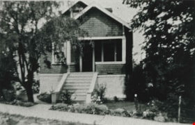
- Photograph of the second Campbell family home at 4120 Eton Street. John Campbell, the family's father, and his friends built this larger house, and then razed the former one on the lot.
- Repository
- City of Burnaby Archives
- Date
- 1930 (date of original), copied 1986
- Collection/Fonds
- Burnaby Historical Society fonds
- Subseries
- Pioneer Tales subseries
- Physical Description
- 1 photograph : b&w ; 12.7 x 17.8 cm print
- Description Level
- Item
- Record No.
- 204-644
- Access Restriction
- No restrictions
- Reproduction Restriction
- No known restrictions
- Accession Number
- BHS1988-03
- Scope and Content
- Photograph of the second Campbell family home at 4120 Eton Street. John Campbell, the family's father, and his friends built this larger house, and then razed the former one on the lot.
- Subjects
- Buildings - Residential - Houses
- Media Type
- Photograph
- Notes
- Title based on contents of photograph
- The former home on this lot is photo 204-643
- Geographic Access
- Eton Street
- Street Address
- 4120 Eton Street
- Historic Neighbourhood
- Vancouver Heights (Historic Neighbourhood)
- Planning Study Area
- Burnaby Heights Area
Images


Firefighters Albert Killer and Fred Blake
https://search.heritageburnaby.ca/link/museumdescription1294
- Repository
- Burnaby Village Museum
- Date
- 1939 (date of original)
- Collection/Fonds
- Burnaby Village Museum Photograph collection
- Description Level
- Item
- Physical Description
- 1 photograph : b&w ; 8.5 x 15 cm print
- Scope and Content
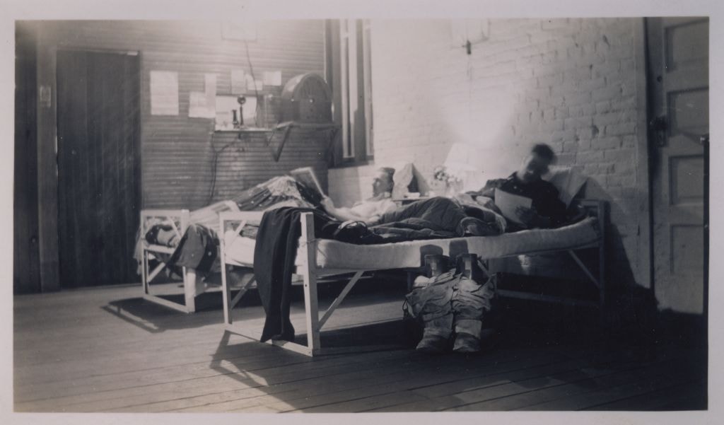
- Photograph of Firefighters Albert Killer and Fred Blake lying down on their beds and reading (in the dormitory during the night shift) at No. 1 Burnaby Fire Hall at Carleton Avenue and Eton Street. Fire boots (with fire resistant pants gathered over them) are visible at the side of Fred Blake's bed.
- Repository
- Burnaby Village Museum
- Collection/Fonds
- Burnaby Village Museum Photograph collection
- Description Level
- Item
- Physical Description
- 1 photograph : b&w ; 8.5 x 15 cm print
- Material Details
- .
- Scope and Content
- Photograph of Firefighters Albert Killer and Fred Blake lying down on their beds and reading (in the dormitory during the night shift) at No. 1 Burnaby Fire Hall at Carleton Avenue and Eton Street. Fire boots (with fire resistant pants gathered over them) are visible at the side of Fred Blake's bed.
- Geographic Access
- Carleton Avenue
- Eton Street
- Accession Code
- BV998.31.3
- Access Restriction
- No restrictions
- Reproduction Restriction
- No known restrictions
- Date
- 1939 (date of original)
- Media Type
- Photograph
- Historic Neighbourhood
- Vancouver Heights (Historic Neighbourhood)
- Planning Study Area
- Burnaby Heights Area
- Scan Resolution
- 600
- Scan Date
- 02-Jun-09
- Scale
- 100
- Notes
- Title based on contents of photograph
- Typed sticker on verso of photograph reads: "Night shift at No.1 Hall/ Carleton Ave. and Eton St. (L) Albert Killer (R) Fred Blake 1939"
- Address sticker on verso of photograph reads: "MR & MRS F BLAKE 4165 PANDORA ST BURNABY BC V5C 2B2"
Images
Standard Oil
https://search.heritageburnaby.ca/link/archivedescription35189
- Repository
- City of Burnaby Archives
- Date
- 1936 (date of original), copied 1986
- Collection/Fonds
- Burnaby Historical Society fonds
- Description Level
- Item
- Physical Description
- 1 photograph : b&w ; 12.7 x 17.8 cm print
- Scope and Content
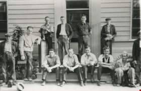
- Photograph of Standard Oil staff, office and refinery at the foot of Queen's Avenue (later renamed Willingdon Avenue). Manager, Mr. Donaldson, is to left; his son, Tommy, is second left. This later became the site of Chevron's Stanovan plant at 4403 Eton Street.
- Repository
- City of Burnaby Archives
- Date
- 1936 (date of original), copied 1986
- Collection/Fonds
- Burnaby Historical Society fonds
- Subseries
- Pioneer Tales subseries
- Physical Description
- 1 photograph : b&w ; 12.7 x 17.8 cm print
- Description Level
- Item
- Record No.
- 204-046
- Access Restriction
- No restrictions
- Reproduction Restriction
- No known restrictions
- Accession Number
- BHS1988-03
- Scope and Content
- Photograph of Standard Oil staff, office and refinery at the foot of Queen's Avenue (later renamed Willingdon Avenue). Manager, Mr. Donaldson, is to left; his son, Tommy, is second left. This later became the site of Chevron's Stanovan plant at 4403 Eton Street.
- Subjects
- Buildings - Industrial - Refineries
- Media Type
- Photograph
- Notes
- Title based on contents of photograph
- Geographic Access
- Eton Street
- Street Address
- 4403 Eton Street
- Historic Neighbourhood
- Vancouver Heights (Historic Neighbourhood)
- Planning Study Area
- Burnaby Heights Area
Images

Standard Oil Company
https://search.heritageburnaby.ca/link/archivedescription34565
- Repository
- City of Burnaby Archives
- Date
- 1936
- Collection/Fonds
- Burnaby Historical Society fonds
- Description Level
- Item
- Physical Description
- 1 photograph : b&w ; 27.2 x 35.0 cm
- Scope and Content
- Photograph of the Standard Oil Company Stanovan Refinery process area, at the Burrard Inlet.
- Repository
- City of Burnaby Archives
- Date
- 1936
- Collection/Fonds
- Burnaby Historical Society fonds
- Subseries
- Photographs subseries
- Physical Description
- 1 photograph : b&w ; 27.2 x 35.0 cm
- Description Level
- Item
- Record No.
- 052-001
- Access Restriction
- No restrictions
- Reproduction Restriction
- No known restrictions
- Accession Number
- BHS2007-04
- Scope and Content
- Photograph of the Standard Oil Company Stanovan Refinery process area, at the Burrard Inlet.
- Subjects
- Buildings - Industrial - Refineries
- Media Type
- Photograph
- Notes
- Title based on contents of photograph
- Geographic Access
- Eton Street
- Street Address
- 4403 Eton Street
- Historic Neighbourhood
- Vancouver Heights (Historic Neighbourhood)
- Planning Study Area
- Burnaby Heights Area
Images

![Standard Oil land clearing, [1935] (date of original), copied 1986 thumbnail](/media/hpo/_Data/_Archives_Images/_Unrestricted/204/204-043.jpg?width=280)
Standard Oil land clearing
https://search.heritageburnaby.ca/link/archivedescription35186
- Repository
- City of Burnaby Archives
- Date
- [1935] (date of original), copied 1986
- Collection/Fonds
- Burnaby Historical Society fonds
- Description Level
- Item
- Physical Description
- 1 photograph : b&w ; 12.7 x 17.8 cm print
- Scope and Content
- Photograph of land being cleared for the Standard Oil Refinery in North Burnaby. The refinery was commonly call Stanovan and was located at the foot of Queens Avenue (now Willingdon street). This later became the site of Chevron's Stanovan plant at 4403 Eton Street.
- Repository
- City of Burnaby Archives
- Date
- [1935] (date of original), copied 1986
- Collection/Fonds
- Burnaby Historical Society fonds
- Subseries
- Pioneer Tales subseries
- Physical Description
- 1 photograph : b&w ; 12.7 x 17.8 cm print
- Description Level
- Item
- Record No.
- 204-043
- Access Restriction
- No restrictions
- Reproduction Restriction
- No known restrictions
- Accession Number
- BHS1988-03
- Scope and Content
- Photograph of land being cleared for the Standard Oil Refinery in North Burnaby. The refinery was commonly call Stanovan and was located at the foot of Queens Avenue (now Willingdon street). This later became the site of Chevron's Stanovan plant at 4403 Eton Street.
- Subjects
- Land Clearing
- Media Type
- Photograph
- Notes
- Title based on contents of photograph
- Geographic Access
- Eton Street
- Street Address
- 4403 Eton Street
- Historic Neighbourhood
- Vancouver Heights (Historic Neighbourhood)
- Planning Study Area
- Burnaby Heights Area
Images
![Standard Oil land clearing, [1935] (date of original), copied 1986 thumbnail](/media/hpo/_Data/_Archives_Images/_Unrestricted/204/204-043.jpg)
![Stanovan Plant, [1936] (date of original), copied 1986 thumbnail](/media/hpo/_Data/_Archives_Images/_Unrestricted/204/204-044.jpg?width=280)
Stanovan Plant
https://search.heritageburnaby.ca/link/archivedescription35187
- Repository
- City of Burnaby Archives
- Date
- [1936] (date of original), copied 1986
- Collection/Fonds
- Burnaby Historical Society fonds
- Description Level
- Item
- Physical Description
- 1 photograph : b&w ; 12.7 x 17.8 cm print
- Scope and Content
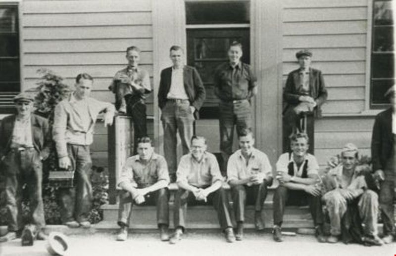
- Photograph of two men taken at the foot of Queens Avenue (now Willingdon Avenue) of a Standard Oil refinery commonly called Stanovan. This later became the site of Chevron's Stanovan plant at 4403 Eton Street.
- Repository
- City of Burnaby Archives
- Date
- [1936] (date of original), copied 1986
- Collection/Fonds
- Burnaby Historical Society fonds
- Subseries
- Pioneer Tales subseries
- Physical Description
- 1 photograph : b&w ; 12.7 x 17.8 cm print
- Description Level
- Item
- Record No.
- 204-044
- Access Restriction
- No restrictions
- Reproduction Restriction
- No known restrictions
- Accession Number
- BHS1988-03
- Scope and Content
- Photograph of two men taken at the foot of Queens Avenue (now Willingdon Avenue) of a Standard Oil refinery commonly called Stanovan. This later became the site of Chevron's Stanovan plant at 4403 Eton Street.
- Subjects
- Buildings - Industrial - Refineries
- Media Type
- Photograph
- Notes
- Title based on contents of photograph
- Geographic Access
- Eton Street
- Street Address
- 4403 Eton Street
- Historic Neighbourhood
- Vancouver Heights (Historic Neighbourhood)
- Planning Study Area
- Burnaby Heights Area
Images
![Stanovan Plant, [1936] (date of original), copied 1986 thumbnail](/media/hpo/_Data/_Archives_Images/_Unrestricted/204/204-044.jpg)
![Stanovan Plant, [1936] (date of original), copied 1986 thumbnail](/media/hpo/_Data/_Archives_Images/_Unrestricted/204/204-045.jpg?width=280)
Stanovan Plant
https://search.heritageburnaby.ca/link/archivedescription35188
- Repository
- City of Burnaby Archives
- Date
- [1936] (date of original), copied 1986
- Collection/Fonds
- Burnaby Historical Society fonds
- Description Level
- Item
- Physical Description
- 1 photograph : b&w ; 12.7 x 17.8 cm print
- Scope and Content
- Photograph of two men taken at the foot of Queens Avenue (now Willingdon Avenue) of a Standard Oil refinery commonly called Stanovan. This later became the site of Chevron's Stanovan plant at 4403 Eton Street.
- Repository
- City of Burnaby Archives
- Date
- [1936] (date of original), copied 1986
- Collection/Fonds
- Burnaby Historical Society fonds
- Subseries
- Pioneer Tales subseries
- Physical Description
- 1 photograph : b&w ; 12.7 x 17.8 cm print
- Description Level
- Item
- Record No.
- 204-045
- Access Restriction
- No restrictions
- Reproduction Restriction
- No known restrictions
- Accession Number
- BHS1988-03
- Scope and Content
- Photograph of two men taken at the foot of Queens Avenue (now Willingdon Avenue) of a Standard Oil refinery commonly called Stanovan. This later became the site of Chevron's Stanovan plant at 4403 Eton Street.
- Subjects
- Buildings - Industrial - Refineries
- Media Type
- Photograph
- Notes
- Title based on contents of photograph
- Geographic Access
- Eton Street
- Street Address
- 4403 Eton Street
- Historic Neighbourhood
- Vancouver Heights (Historic Neighbourhood)
- Planning Study Area
- Burnaby Heights Area
Images
![Stanovan Plant, [1936] (date of original), copied 1986 thumbnail](/media/hpo/_Data/_Archives_Images/_Unrestricted/204/204-045.jpg)