Narrow Results By
Subject
- Agriculture - Fruit and Berries 1
- Animals - Birds 1
- Animals - Dogs 3
- Building Components 10
- Building Components - Fireplaces 1
- Buildings 5
- Buildings - Agricultural 3
- Buildings - Agricultural - Greenhouses 1
- Buildings - Agricultural - Stables 1
- Buildings - Civic 3
- Buildings - Civic - Art Galleries 7
- Buildings - Civic - Community Centres 1
![Sandy Stewart sweeping porch of Elworth House, Heritage Village, [1971] thumbnail](/media/hpo/_Data/_BVM_Images/2005/2005_0054_0552_001.jpg?width=280)
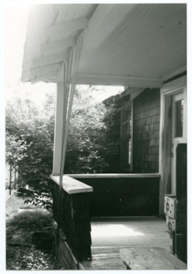
Sandy Stewart sweeping porch of Elworth House, Heritage Village
https://search.heritageburnaby.ca/link/museumdescription2503
- Repository
- Burnaby Village Museum
- Date
- [1971]
- Collection/Fonds
- Donald Copan collection
- Description Level
- Item
- Physical Description
- 1 photograph : b&w ; 8.9 x 8.9 cm
- Scope and Content
- Photograph of Burnaby Centennial '71 Committee member, Sandy Stewart sweeping the front porch of Elworth House at Heritage Village (now Burnaby Village Museum).
- Repository
- Burnaby Village Museum
- Collection/Fonds
- Donald Copan collection
- Series
- Copan album series
- Description Level
- Item
- Physical Description
- 1 photograph : b&w ; 8.9 x 8.9 cm
- Scope and Content
- Photograph of Burnaby Centennial '71 Committee member, Sandy Stewart sweeping the front porch of Elworth House at Heritage Village (now Burnaby Village Museum).
- Names
- Stewart, A.B. "Sandy"
- Elworthy, Joseph
- Burnaby Centennial '71 Committee
- Burnaby Village Museum
- Accession Code
- BV005.54.552
- Access Restriction
- No restrictions
- Reproduction Restriction
- May be restricted by third party rights
- Date
- [1971]
- Media Type
- Photograph
- Scan Resolution
- 600
- Scan Date
- August 18, 2020
- Scale
- 100
- Notes
- Title based on contents of photograph
Images
![Sandy Stewart sweeping porch of Elworth House, Heritage Village, [1971] thumbnail](/media/hpo/_Data/_BVM_Images/2005/2005_0054_0552_001.jpg)

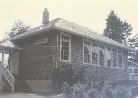
Seaforth School
https://search.heritageburnaby.ca/link/archivedescription38300
- Repository
- City of Burnaby Archives
- Date
- 1987
- Collection/Fonds
- Burnaby Historical Society fonds
- Description Level
- Item
- Physical Description
- 1 photograph : b&w ; 12.5 x 17.5 cm
- Scope and Content
- Photograph of the Seaforth School building which was originally built in the Lozells neighbourhood in North Burnaby in 1922. In 1983, the school was moved to its current site on the grounds of the Burnaby Village Museum and it remains a protected heritage building in Burnaby.
- Repository
- City of Burnaby Archives
- Date
- 1987
- Collection/Fonds
- Burnaby Historical Society fonds
- Subseries
- Photographs subseries
- Physical Description
- 1 photograph : b&w ; 12.5 x 17.5 cm
- Description Level
- Item
- Record No.
- 398-007
- Access Restriction
- No restrictions
- Reproduction Restriction
- Reproduce for fair dealing purposes only
- Accession Number
- BHS2007-04
- Scope and Content
- Photograph of the Seaforth School building which was originally built in the Lozells neighbourhood in North Burnaby in 1922. In 1983, the school was moved to its current site on the grounds of the Burnaby Village Museum and it remains a protected heritage building in Burnaby.
- Subjects
- Buildings - Heritage
- Buildings - Schools
- Names
- Seaforth School
- Media Type
- Photograph
- Notes
- Title based on contents of photograph.
- Geographic Access
- Deer Lake Avenue
- Street Address
- 6501 Deer Lake Avenue
- Historic Neighbourhood
- Burnaby Lake (Historic Neighbourhood)
- Planning Study Area
- Morley-Buckingham Area
Images
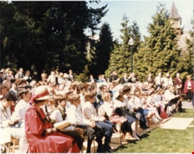
Seaforth Schoolhouse Opening
https://search.heritageburnaby.ca/link/archivedescription58232
- Repository
- City of Burnaby Archives
- Date
- April 10, 1987
- Collection/Fonds
- Burnaby Historical Society fonds
- Description Level
- Item
- Physical Description
- 1 photograph : col. ; 10 x 12.5 cm
- Scope and Content
- Photograph of the audience at the opening of Seaforth Schoolhouse at Burnaby Village Museum.
- Repository
- City of Burnaby Archives
- Date
- April 10, 1987
- Collection/Fonds
- Burnaby Historical Society fonds
- Subseries
- Evelyn Salisbury subseries
- Physical Description
- 1 photograph : col. ; 10 x 12.5 cm
- Description Level
- Item
- Record No.
- 261-018
- Access Restriction
- No restrictions
- Reproduction Restriction
- Reproduce for fair dealing purposes only
- Accession Number
- BHS1991-24
- Scope and Content
- Photograph of the audience at the opening of Seaforth Schoolhouse at Burnaby Village Museum.
- Subjects
- Buildings - Heritage
- Media Type
- Photograph
- Notes
- Title based on contents of photograph
- Note on verso reads: "Fri. Apr. 10/87 B.V.M. / Seaforth Schoolhouse c. 1922-1983"
- Historic Neighbourhood
- Burnaby Lake (Historic Neighbourhood)
- Planning Study Area
- Burnaby Lake Area
Images


Shearer Shack
https://search.heritageburnaby.ca/link/archivedescription70546
- Repository
- City of Burnaby Archives
- Date
- 1911
- Collection/Fonds
- Shearer Family fonds
- Description Level
- Item
- Physical Description
- 1 photograph (jpeg)
- Scope and Content
- Photograph of Jim Shearer, his wife Katherine (Dormer), and their daughter, Katie, posed in front of the temporary shelter erected at 5573 Buckingham Avenue during the construction of their home on that site, which was commissioned by Katherine's father, Francis Joseph Dormer. The image was taken s…
- Repository
- City of Burnaby Archives
- Date
- 1911
- Collection/Fonds
- Shearer Family fonds
- Physical Description
- 1 photograph (jpeg)
- Description Level
- Item
- Record No.
- 530-001
- Access Restriction
- No restrictions
- Reproduction Restriction
- No known restrictions
- Accession Number
- 2012-05
- Scope and Content
- Photograph of Jim Shearer, his wife Katherine (Dormer), and their daughter, Katie, posed in front of the temporary shelter erected at 5573 Buckingham Avenue during the construction of their home on that site, which was commissioned by Katherine's father, Francis Joseph Dormer. The image was taken shortly before their son James Francis was born.
- Media Type
- Photograph
- Photographer
- Shearer, Tony
- Geographic Access
- Buckingham Avenue
- Street Address
- 5573 Buckingham Avenue
- Historic Neighbourhood
- Burnaby Lake (Historic Neighbourhood)
- Planning Study Area
- Morley-Buckingham Area
Images

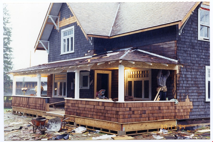
Shingling of porch railings
https://search.heritageburnaby.ca/link/museumdescription11470
- Repository
- Burnaby Village Museum
- Date
- 1994
- Collection/Fonds
- Burnaby Village Museum fonds
- Description Level
- Item
- Physical Description
- 1 photograph : col. negative ; 35 mm
- Scope and Content
- Photograph of the shingling of the porch railing on the Love farmhouse.
- Repository
- Burnaby Village Museum
- Collection/Fonds
- Burnaby Village Museum fonds
- Series
- Jesse Love farmhouse series
- Description Level
- Item
- Physical Description
- 1 photograph : col. negative ; 35 mm
- Scope and Content
- Photograph of the shingling of the porch railing on the Love farmhouse.
- Subjects
- Buildings - Heritage
- Names
- Burnaby Village Museum
- Accession Code
- BV018.41.586
- Date
- 1994
- Media Type
- Photograph
- Scan Resolution
- 600
- Scan Date
- 08-Jul-19
- Scale
- 100
- Notes
- Title based on contents of photograph
- 1 col. photograph print accompanying negative
- Photograph is part of Section 2: "Porches" from Restoration Album BV018.41.81
Images
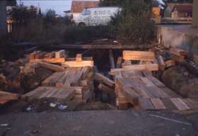
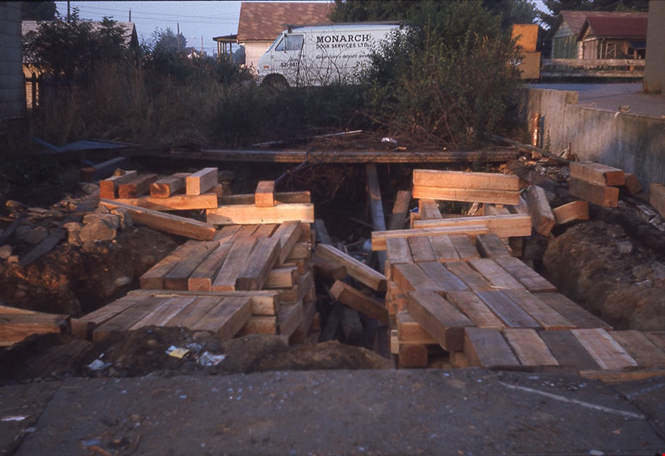
Site of former Whitechurch Hardware building
https://search.heritageburnaby.ca/link/museumdescription16903
- Repository
- Burnaby Village Museum
- Date
- Aug. 1974
- Collection/Fonds
- Burnaby Village Museum fonds
- Description Level
- Item
- Physical Description
- 1 photograph : col. slide ; 35 mm
- Scope and Content
- Photograph of timbers on the ground after the Whitechurch Hardware building was moved by Nickel Brothers house moving company from 7685 Sixth Street to Heritage Village (Burnaby Village Museum.
- Repository
- Burnaby Village Museum
- Collection/Fonds
- Burnaby Village Museum fonds
- Subseries
- Bell's building photographs subseries
- Description Level
- Item
- Physical Description
- 1 photograph : col. slide ; 35 mm
- Scope and Content
- Photograph of timbers on the ground after the Whitechurch Hardware building was moved by Nickel Brothers house moving company from 7685 Sixth Street to Heritage Village (Burnaby Village Museum.
- Geographic Access
- 6th Street
- Street Address
- 7685 6th Street
- Accession Code
- BV020.5.1873
- Access Restriction
- No restrictions
- Reproduction Restriction
- No known restrictions
- Date
- Aug. 1974
- Media Type
- Photograph
- Historic Neighbourhood
- East Burnaby (Historic Neighbourhood)
- Planning Study Area
- Second Street Area
- Scan Resolution
- 2400
- Scale
- 100
- Notes
- Title based on contents of photograph
- Note in blue ink on slide frame reads: "Timbers after / Whitechurch / removed from site"
Images
![Somerset House and Thames Embankment, [1880] thumbnail](/media/hpo/_Data/_Archives_Images/_Unrestricted/477/477-767.jpg?width=280)
Somerset House and Thames Embankment
https://search.heritageburnaby.ca/link/archivedescription39448
- Repository
- City of Burnaby Archives
- Date
- [1880]
- Collection/Fonds
- Peers Family and Hill Family fonds
- Description Level
- Item
- Physical Description
- 1 photograph : sepia ; 10.5 x 17.5 cm on page 21.5 x 28 cm (pasted in album)
- Scope and Content
- Photograph of the Somerset House and Thames Embankment in England. This photograph was in a scrapbook kept by Claude Hill who was originally from England but ultimately settled in the Burnaby Lake area.
- Repository
- City of Burnaby Archives
- Date
- [1880]
- Collection/Fonds
- Peers Family and Hill Family fonds
- Physical Description
- 1 photograph : sepia ; 10.5 x 17.5 cm on page 21.5 x 28 cm (pasted in album)
- Description Level
- Item
- Record No.
- 477-767
- Access Restriction
- No restrictions
- Reproduction Restriction
- No known restrictions
- Accession Number
- 2007-12
- Scope and Content
- Photograph of the Somerset House and Thames Embankment in England. This photograph was in a scrapbook kept by Claude Hill who was originally from England but ultimately settled in the Burnaby Lake area.
- Subjects
- Buildings - Heritage
- Media Type
- Photograph
- Notes
- Title based on caption accompanying photograph
Images
![Somerset House and Thames Embankment, [1880] thumbnail](/media/hpo/_Data/_Archives_Images/_Unrestricted/477/477-767.jpg)
South side of Love farmhouse
https://search.heritageburnaby.ca/link/museumdescription11490
- Repository
- Burnaby Village Museum
- Date
- 1995
- Collection/Fonds
- Burnaby Village Museum fonds
- Description Level
- Item
- Physical Description
- 1 photograph : col. ; 15 x 10 cm
- Scope and Content
- Photograph of the south side of the Love farmhouse during shingle restoration and painting. New shingles have been installed on main part of house and porch railing.
- Repository
- Burnaby Village Museum
- Collection/Fonds
- Burnaby Village Museum fonds
- Series
- Jesse Love farmhouse series
- Description Level
- Item
- Physical Description
- 1 photograph : col. ; 15 x 10 cm
- Scope and Content
- Photograph of the south side of the Love farmhouse during shingle restoration and painting. New shingles have been installed on main part of house and porch railing.
- Subjects
- Buildings - Heritage
- Names
- Burnaby Village Museum
- Accession Code
- BV018.41.606
- Date
- 1995
- Media Type
- Photograph
- Scan Resolution
- 600
- Scan Date
- July 2019
- Scale
- 100
- Notes
- Title based on contents of photograph
- Photograph is part of Restoration Photograph album BV018.41.81 - Section 4: "Shingles and Painting"
Images

South side, west end of porch
https://search.heritageburnaby.ca/link/museumdescription10717
- Repository
- Burnaby Village Museum
- Date
- May 4, 1988
- Collection/Fonds
- Burnaby Village Museum fonds
- Description Level
- Item
- Physical Description
- 1 photograph : b&w ; 9 x 13 cm
- Scope and Content
- Photograph of the south side, west end of the porch on the Love farmhouse located at 7651 Cumberland Street (the corner of 14th Avenue and Cumberland Street).
- Repository
- Burnaby Village Museum
- Collection/Fonds
- Burnaby Village Museum fonds
- Series
- Jesse Love farmhouse series
- Description Level
- Item
- Physical Description
- 1 photograph : b&w ; 9 x 13 cm
- Material Details
- Photograph is part of Film roll "B" -24 b&w photographs that are a part of a collection described as BV018.41.82
- Scope and Content
- Photograph of the south side, west end of the porch on the Love farmhouse located at 7651 Cumberland Street (the corner of 14th Avenue and Cumberland Street).
- Subjects
- Buildings - Heritage
- Geographic Access
- Cumberland Street
- Street Address
- 7651 Cumberland Street
- Accession Code
- BV018.41.240
- Access Restriction
- No restrictions
- Reproduction Restriction
- No known restrictions
- Date
- May 4, 1988
- Media Type
- Photograph
- Historic Neighbourhood
- East Burnaby (Historic Neighbourhood)
- Planning Study Area
- Cariboo-Armstrong Area
- Related Material
- See BV018.41.82 for File Level Description
- Scan Resolution
- 600
- Scan Date
- 27-May-19
- Scale
- 100
- Photographer
- Wolf, Jim
- Notes
- Title based on contents of photograph
- Photograph is a part of file level description "Photographic documentation of changes and move" BV018.41.82
Images

South view of Love House outbuilding in next yard
https://search.heritageburnaby.ca/link/museumdescription10761
- Repository
- Burnaby Village Museum
- Date
- May 6, 1988
- Collection/Fonds
- Burnaby Village Museum fonds
- Description Level
- Item
- Physical Description
- 1 photograph : b&w negative ; 35 mm
- Scope and Content
- South view of the Love farmhouse outbuilding in the next yard. The house is located at 7651 Cumberland Street (the corner of 14th Avenue and Cumberland Street).
- Repository
- Burnaby Village Museum
- Collection/Fonds
- Burnaby Village Museum fonds
- Series
- Jesse Love farmhouse series
- Description Level
- Item
- Physical Description
- 1 photograph : b&w negative ; 35 mm
- Material Details
- Photograph is part of Film roll "C" - 36 b&w photographs that are a part of a collection described as BV018.41.83
- Scope and Content
- South view of the Love farmhouse outbuilding in the next yard. The house is located at 7651 Cumberland Street (the corner of 14th Avenue and Cumberland Street).
- Subjects
- Buildings - Heritage
- Geographic Access
- Cumberland Street
- Street Address
- 7651 Cumberland Street
- Accession Code
- BV018.41.284
- Access Restriction
- No restrictions
- Reproduction Restriction
- No known restrictions
- Date
- May 6, 1988
- Media Type
- Photograph
- Historic Neighbourhood
- East Burnaby (Historic Neighbourhood)
- Planning Study Area
- Cariboo-Armstrong Area
- Related Material
- See BV018.41.82 for File Level Description
- Scan Resolution
- 2400
- Scan Date
- 5/19/2019
- Scale
- 100
- Photographer
- Wolf, Jim
- Notes
- Title based on contents of photograph
- Photograph is a part of file level description "Photographic documentation of changes and move" BV018.41.82
Images

Southwest elevation
https://search.heritageburnaby.ca/link/museumdescription10697
- Repository
- Burnaby Village Museum
- Date
- May 4, 1988
- Collection/Fonds
- Burnaby Village Museum fonds
- Description Level
- Item
- Physical Description
- 1 photograph : col. negative ; 35 mm
- Scope and Content
- Photograph of the southwest elevation of the Love farmhouse located at 7651 Cumberland Street (the corner of 14th Avenue and Cumberland Street).The photograph was taken of the house once it was saved and acquired by the Burnaby Village Museum. View includes kitchen.
- Repository
- Burnaby Village Museum
- Collection/Fonds
- Burnaby Village Museum fonds
- Series
- Jesse Love farmhouse series
- Description Level
- Item
- Physical Description
- 1 photograph : col. negative ; 35 mm
- Material Details
- Photograph is part of Film roll "A"- 15 colour prints that are a part of a collection described as BV018.41.82
- Scope and Content
- Photograph of the southwest elevation of the Love farmhouse located at 7651 Cumberland Street (the corner of 14th Avenue and Cumberland Street).The photograph was taken of the house once it was saved and acquired by the Burnaby Village Museum. View includes kitchen.
- Subjects
- Buildings - Heritage
- Geographic Access
- Cumberland Street
- Street Address
- 7651 Cumberland Street
- Accession Code
- BV018.41.220
- Access Restriction
- No restrictions
- Reproduction Restriction
- No known restrictions
- Date
- May 4, 1988
- Media Type
- Photograph
- Historic Neighbourhood
- East Burnaby (Historic Neighbourhood)
- Planning Study Area
- Cariboo-Armstrong Area
- Related Material
- See BV018.41.82 for File Level Description
- Scan Resolution
- 2400
- Scan Date
- 5/19/2019
- Scale
- 100
- Photographer
- Wolf, Jim
- Notes
- Title based on contents of photograph
- Photograph is a part of file level description "Photographic documentation of changes and move" BV018.41.82
Images


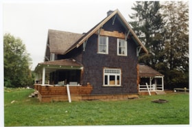
Southwest side of Love farmhouse
https://search.heritageburnaby.ca/link/museumdescription11492
- Repository
- Burnaby Village Museum
- Date
- 1995
- Collection/Fonds
- Burnaby Village Museum fonds
- Description Level
- Item
- Physical Description
- 1 photograph : col. ; 15 x 10 cm
- Scope and Content
- Photograph of the south west side of the Love farmhouse during shingle restoration. New shingles have been installed on main part of house and porch railing.
- Repository
- Burnaby Village Museum
- Collection/Fonds
- Burnaby Village Museum fonds
- Series
- Jesse Love farmhouse series
- Description Level
- Item
- Physical Description
- 1 photograph : col. ; 15 x 10 cm
- Scope and Content
- Photograph of the south west side of the Love farmhouse during shingle restoration. New shingles have been installed on main part of house and porch railing.
- Subjects
- Buildings - Heritage
- Names
- Burnaby Village Museum
- Accession Code
- BV018.41.608
- Date
- 1995
- Media Type
- Photograph
- Scan Resolution
- 600
- Scan Date
- July 2019
- Scale
- 100
- Notes
- Title based on contents of photograph
- Photograph is part of Restoration Photograph album BV018.41.81 - Section 4: "Shingles and Painting"
Images

Southwest view
https://search.heritageburnaby.ca/link/museumdescription10810
- Repository
- Burnaby Village Museum
- Date
- April 8, 1988
- Collection/Fonds
- Burnaby Village Museum fonds
- Description Level
- Item
- Physical Description
- 1 photograph : col. negative ; 35 mm
- Scope and Content
- Southwest view of the Love farmhouse while it was located at 7651 Cumberland Street (the corner of 14th Avenue and Cumberland Street). The photograph was taken of the house once it was saved and acquired by the Burnaby Village Museum.
- Repository
- Burnaby Village Museum
- Collection/Fonds
- Burnaby Village Museum fonds
- Series
- Jesse Love farmhouse series
- Description Level
- Item
- Physical Description
- 1 photograph : col. negative ; 35 mm
- Material Details
- Photograph is part of Film roll "F" - 23 colour photographs that are a part of a collection described as BV018.41.82
- Scope and Content
- Southwest view of the Love farmhouse while it was located at 7651 Cumberland Street (the corner of 14th Avenue and Cumberland Street). The photograph was taken of the house once it was saved and acquired by the Burnaby Village Museum.
- Subjects
- Buildings - Heritage
- Geographic Access
- Cumberland Street
- Street Address
- 7651 Cumberland Street
- Accession Code
- BV018.41.332
- Access Restriction
- No restrictions
- Reproduction Restriction
- No known restrictions
- Date
- April 8, 1988
- Media Type
- Photograph
- Historic Neighbourhood
- East Burnaby (Historic Neighbourhood)
- Planning Study Area
- Cariboo-Armstrong Area
- Related Material
- See BV018.41.82 for File Level Description
- Scan Resolution
- 2400
- Scan Date
- 13-May-19
- Scale
- 100
- Photographer
- Wolf, Jim
- Notes
- Title based on contents of photograph
- Photograph is a part of file level description "Photographic documentation of changes and move" BV018.41.82
Images

![Sprott house site, [1990] thumbnail](/media/hpo/_Data/_Archives_Images/_Unrestricted/371/422-004.jpg?width=280)
Sprott house site
https://search.heritageburnaby.ca/link/archivedescription38373
- Repository
- City of Burnaby Archives
- Date
- [1990]
- Collection/Fonds
- Burnaby Historical Society fonds
- Description Level
- Item
- Physical Description
- 1 photograph : b&w ; 9 x 13 cm
- Scope and Content
- Photograph of the site of Mayfield Lodge which was owned by L.E.Sprott (Canada Way).
- Repository
- City of Burnaby Archives
- Date
- [1990]
- Collection/Fonds
- Burnaby Historical Society fonds
- Subseries
- Municipal record subseries
- Physical Description
- 1 photograph : b&w ; 9 x 13 cm
- Description Level
- Item
- Record No.
- 422-004
- Access Restriction
- No restrictions
- Reproduction Restriction
- Reproduce for fair dealing purposes only
- Accession Number
- BHS2001-09
- Scope and Content
- Photograph of the site of Mayfield Lodge which was owned by L.E.Sprott (Canada Way).
- Subjects
- Buildings - Heritage
- Media Type
- Photograph
- Photographer
- Wolf, Jim
- Notes
- Title based on contents of photograph
- Geographic Access
- Canada Way
- Historic Neighbourhood
- Burnaby Lake (Historic Neighbourhood)
- Planning Study Area
- Morley-Buckingham Area
Images
![Sprott house site, [1990] thumbnail](/media/hpo/_Data/_Archives_Images/_Unrestricted/371/422-004.jpg)
![Sprott house site, [1990] thumbnail](/media/hpo/_Data/_Archives_Images/_Unrestricted/371/422-006.jpg?width=280)
Sprott house site
https://search.heritageburnaby.ca/link/archivedescription38375
- Repository
- City of Burnaby Archives
- Date
- [1990]
- Collection/Fonds
- Burnaby Historical Society fonds
- Description Level
- Item
- Physical Description
- 1 photograph : col. ; 8.8 x 13 cm
- Scope and Content
- Photograph of the site of Mayfield Lodge which was owned by L.E.Sprott (Canada Way).
- Repository
- City of Burnaby Archives
- Date
- [1990]
- Collection/Fonds
- Burnaby Historical Society fonds
- Subseries
- Municipal record subseries
- Physical Description
- 1 photograph : col. ; 8.8 x 13 cm
- Description Level
- Item
- Record No.
- 422-006
- Access Restriction
- No restrictions
- Reproduction Restriction
- Reproduce for fair dealing purposes only
- Accession Number
- BHS2001-09
- Scope and Content
- Photograph of the site of Mayfield Lodge which was owned by L.E.Sprott (Canada Way).
- Subjects
- Buildings - Heritage
- Media Type
- Photograph
- Photographer
- Wolf, Jim
- Notes
- Title based on contents of photograph.
- Geographic Access
- Canada Way
- Historic Neighbourhood
- Burnaby Lake (Historic Neighbourhood)
- Planning Study Area
- Morley-Buckingham Area
Images
![Sprott house site, [1990] thumbnail](/media/hpo/_Data/_Archives_Images/_Unrestricted/371/422-006.jpg)
![St. John the Divine Anglican Church renovations, [2005] thumbnail](/media/hpo/_Data/_Archives_Images/_Unrestricted/535/535-1876.jpg?width=280)
St. John the Divine Anglican Church renovations
https://search.heritageburnaby.ca/link/archivedescription96179
- Repository
- City of Burnaby Archives
- Date
- [2005]
- Collection/Fonds
- Burnaby NewsLeader photograph collection
- Description Level
- Item
- Physical Description
- 1 photograph (tiff) : col.
- Scope and Content
- Photograph of two workers from Companion Construction cutting a board during renovations to St. John the Divine Anglican Church on Kingsway, after it was designated as a heritage site.
- Repository
- City of Burnaby Archives
- Date
- [2005]
- Collection/Fonds
- Burnaby NewsLeader photograph collection
- Physical Description
- 1 photograph (tiff) : col.
- Description Level
- Item
- Record No.
- 535-1876
- Access Restriction
- No restrictions
- Reproduction Restriction
- No restrictions
- Accession Number
- 2018-12
- Scope and Content
- Photograph of two workers from Companion Construction cutting a board during renovations to St. John the Divine Anglican Church on Kingsway, after it was designated as a heritage site.
- Media Type
- Photograph
- Photographer
- Bartel, Mario
- Notes
- Title based on caption
- Collected by editorial for use in a January 2005 issue of the Burnaby NewsLeader
- Caption from metadata: "Gary Janzen and Ron Koehn, of Companion Construction, are nearing completion of a six-month project to renovate St. John the Divine Church, on Kingsway in Burnaby. The church is the oldest in Burnaby, built in 1905, and has been designated a heritage site. When the work is completed, it will be sold."
- Geographic Access
- Kingsway
- Street Address
- 3891 Kingsway
- Historic Neighbourhood
- Central Park (Historic Neighbourhood)
- Planning Study Area
- Garden Village Area
Images
![St. John the Divine Anglican Church renovations, [2005] thumbnail](/media/hpo/_Data/_Archives_Images/_Unrestricted/535/535-1876.jpg)
![St. John the Divine Anglican Church restoration, [2005] thumbnail](/media/hpo/_Data/_Archives_Images/_Unrestricted/535/535-1950.jpg?width=280)
St. John the Divine Anglican Church restoration
https://search.heritageburnaby.ca/link/archivedescription96267
- Repository
- City of Burnaby Archives
- Date
- [2005]
- Collection/Fonds
- Burnaby NewsLeader photograph collection
- Description Level
- Item
- Physical Description
- 1 photograph (tiff) : col.
- Scope and Content
- Photograph of Ron Koehn of Companion Construction Ltd. standing inside the restored St. John the Divine Church in Burnaby. Koehn is standing next to the large, newly-installed stained glass windows.
- Repository
- City of Burnaby Archives
- Date
- [2005]
- Collection/Fonds
- Burnaby NewsLeader photograph collection
- Physical Description
- 1 photograph (tiff) : col.
- Description Level
- Item
- Record No.
- 535-1950
- Access Restriction
- No restrictions
- Reproduction Restriction
- No restrictions
- Accession Number
- 2018-12
- Scope and Content
- Photograph of Ron Koehn of Companion Construction Ltd. standing inside the restored St. John the Divine Church in Burnaby. Koehn is standing next to the large, newly-installed stained glass windows.
- Media Type
- Photograph
- Photographer
- Bartel, Mario
- Notes
- Title based on caption
- Collected by editorial for use in a February 2005 issue of the Burnaby NewsLeader
- Caption from metadata: "Ron Koehn, of Companion Construction Ltd., admires the newly-installed stain glass windows at St. John the Divine Church in Burnaby. The church, the oldest in the city, is nearing completion of a restoration project before it will be sold to new owners."
- Geographic Access
- Kingsway
- Street Address
- 3891 Kingsway
- Historic Neighbourhood
- Central Park (Historic Neighbourhood)
- Planning Study Area
- Garden Village Area
Images
![St. John the Divine Anglican Church restoration, [2005] thumbnail](/media/hpo/_Data/_Archives_Images/_Unrestricted/535/535-1950.jpg)

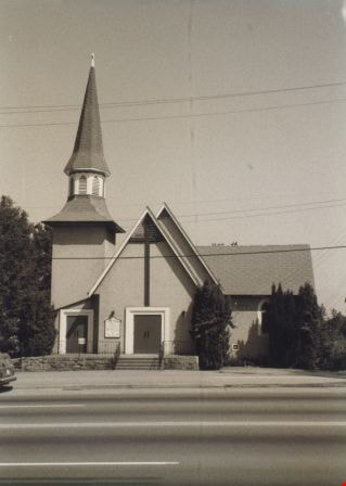
St. John The Divine Church
https://search.heritageburnaby.ca/link/archivedescription38297
- Repository
- City of Burnaby Archives
- Date
- 1985
- Collection/Fonds
- Burnaby Historical Society fonds
- Description Level
- Item
- Physical Description
- 1 photograph : b&w ; 12.6 x 17.6 cm
- Scope and Content
- Photograph of the exterior of St. John the Divine Anglican Church, at 3891 Kingsway.
- Repository
- City of Burnaby Archives
- Date
- 1985
- Collection/Fonds
- Burnaby Historical Society fonds
- Subseries
- Photographs subseries
- Physical Description
- 1 photograph : b&w ; 12.6 x 17.6 cm
- Description Level
- Item
- Record No.
- 398-004
- Access Restriction
- No restrictions
- Reproduction Restriction
- Reproduce for fair dealing purposes only
- Accession Number
- BHS2007-04
- Scope and Content
- Photograph of the exterior of St. John the Divine Anglican Church, at 3891 Kingsway.
- Media Type
- Photograph
- Notes
- Title based on contents of photograph.
- Geographic Access
- Kingsway
- Westminster Avenue
- Street Address
- 3891 Kingsway
- Historic Neighbourhood
- Central Park (Historic Neighbourhood)
- Planning Study Area
- Garden Village Area
Images
![St. Paul's Cathedral, [1880] thumbnail](/media/hpo/_Data/_Archives_Images/_Unrestricted/477/477-765.jpg?width=280)
St. Paul's Cathedral
https://search.heritageburnaby.ca/link/archivedescription39446
- Repository
- City of Burnaby Archives
- Date
- [1880]
- Collection/Fonds
- Peers Family and Hill Family fonds
- Description Level
- Item
- Physical Description
- 1 photograph : sepia ; 10.5 x 17.5 cm on page 21.5 x 28 cm (pasted in album)
- Scope and Content
- Photograph of St. Paul's Cathedral in England. This item was in a scrapbook kept by Claude Hill who was originally from England but ultimately settled in the Burnaby Lake area.
- Repository
- City of Burnaby Archives
- Date
- [1880]
- Collection/Fonds
- Peers Family and Hill Family fonds
- Physical Description
- 1 photograph : sepia ; 10.5 x 17.5 cm on page 21.5 x 28 cm (pasted in album)
- Description Level
- Item
- Record No.
- 477-765
- Access Restriction
- No restrictions
- Reproduction Restriction
- No known restrictions
- Accession Number
- 2007-12
- Scope and Content
- Photograph of St. Paul's Cathedral in England. This item was in a scrapbook kept by Claude Hill who was originally from England but ultimately settled in the Burnaby Lake area.
- Media Type
- Photograph
- Notes
- Title based on caption accompanying photograph
Images
![St. Paul's Cathedral, [1880] thumbnail](/media/hpo/_Data/_Archives_Images/_Unrestricted/477/477-765.jpg)
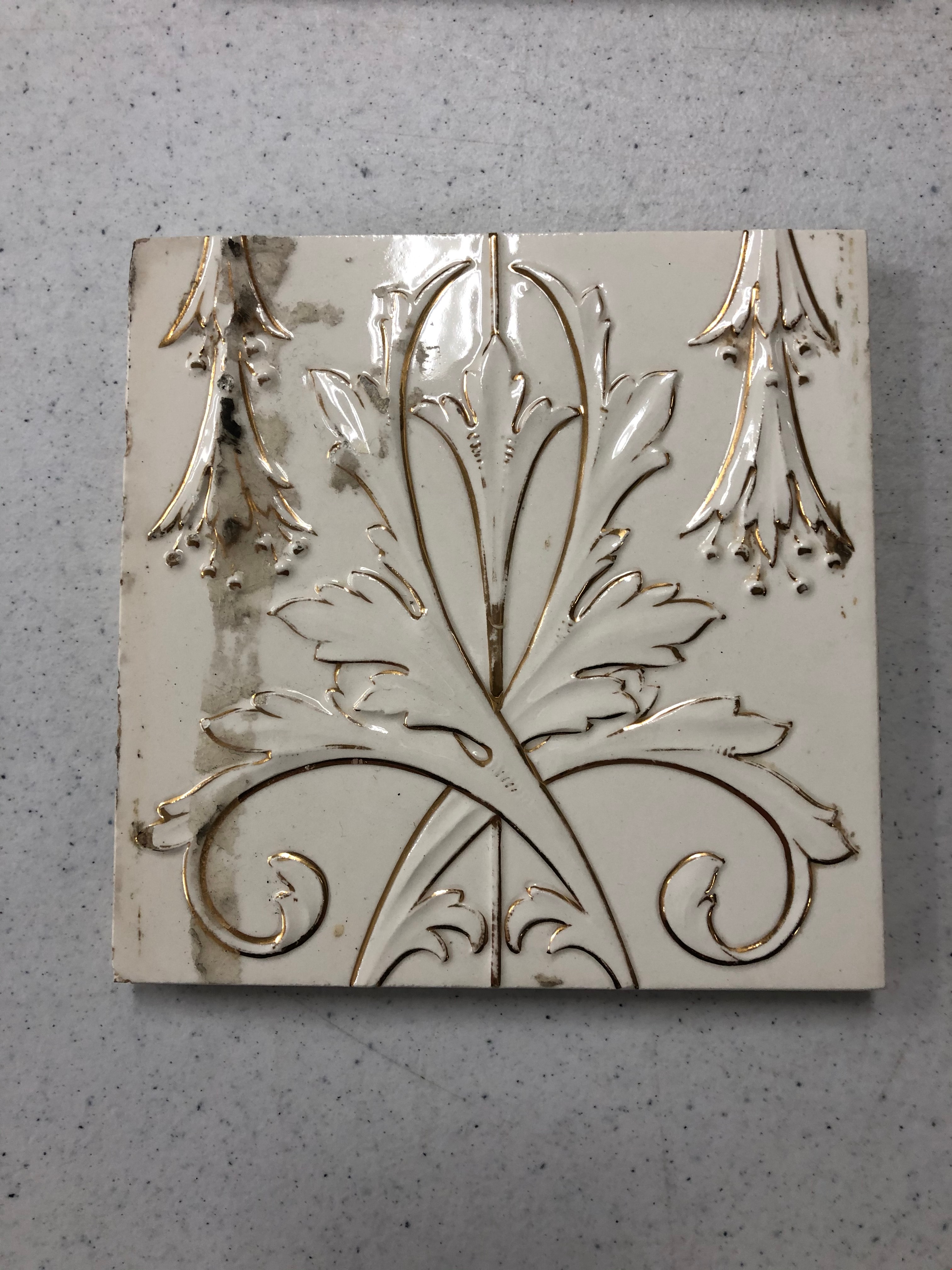
Tile
https://search.heritageburnaby.ca/link/museumartifact90823
- Repository
- Burnaby Village Museum
- Accession Code
- BV020.40.14
- Description
- White ceramic tile with gold design. The design is made up of a gold line down the centre, and one small flower 3/4 of the way up with two leaves crossed over one another. On either side of the middle design are two trumpeted flowers pointing down from the top of the tile. There is a brown stain all the way down the left handside, over top of the trumpeted flower.
- Object History
- These tiles are from Glenedward Mansion, built in 1912. It was built at 3412 Kingsway, which later became 5152 Kingsway. They were salvaged when the mansion was demolished in the 1990s.
- Category
- 01. Built Environment Objects
- Classification
- Building Components - - Surface Elements
- Object Term
- Tile, Decorative
- Colour
- White
- Gold
- Measurements
- 6" x 6"
- Subjects
- Building Components
- Buildings - Heritage
- Historic Neighbourhood
- Edmonds (Historic Neighbourhood)
- Planning Study Area
- Windsor Area
Images