Narrow Results By
Subject
- Agriculture - Fruit and Berries 3
- Buildings - Commercial - Department Stores 10
- Buildings - Commercial - Grocery Stores 2
- Buildings - Heritage 12
- Buildings - Industrial - Factories 1
- Buildings - Other 1
- Buildings - Religious - Churches 12
- Buildings - Residential 1
- Buildings - Residential - Houses 7
- Buildings - Schools 18
- Businesses - Real Estate Agencies 1
- Documentary Artifacts - Architectural Drawings 1
Creator
- Adams, Edith 1
- Associated Factory Mutual Fire Insurance Cos 1
- Atkinson, R. 1
- Bateman, Caroline Mary Wettenhall 1
- B.C. Tree Fruits Limited 1
- Bekins Moving and Storage Company Limited 1
- Bingham, Alfred "Alf" 2
- Bolton, Richard 1
- Brainerd family 1
- Burnaby Art Gallery 1
- Burnaby Centennial '71 Committee 1
- Burnaby Lake Men’s Community Service Club 1
Person / Organization
- All Saints Anglican Church 1
- Armstrong Avenue School 1
- Barnet School 1
- Broadview Presbyterian Church 1
- Burnaby Advisory Planning Commission 1
- Burnaby Historical Society 2
- Burnaby Village Museum 5
- Carr, William Harold 1
- Century Park Museum Association 2
- Chamberlain, Annie McKenzie 2
- Dominion Bridge Company 1
- Douglas Road School 1
4th Street encroachments
https://search.heritageburnaby.ca/link/archivedescription268
- Repository
- City of Burnaby Archives
- Date
- 1910-1913
- Collection/Fonds
- City Council and Office of the City Clerk fonds
- Description Level
- File
- Physical Description
- Textual record
- Scope and Content
- File contains records relating to the encroachment of building lots upon the street which impeded the construction of the 4th Street sidewalk.
- Repository
- City of Burnaby Archives
- Date
- 1910-1913
- Collection/Fonds
- City Council and Office of the City Clerk fonds
- Physical Description
- Textual record
- Description Level
- File
- Record No.
- 1958
- Accession Number
- 2001-02
- Scope and Content
- File contains records relating to the encroachment of building lots upon the street which impeded the construction of the 4th Street sidewalk.
- Media Type
- Textual Record
![1892 Burnaby Centennial, [1992] thumbnail](/media/hpo/_Data/_BVM_Cartographic_Material/2013/2013_0008_0001_001.jpg?width=280)
1892 Burnaby Centennial
https://search.heritageburnaby.ca/link/museumdescription8704
- Repository
- Burnaby Village Museum
- Date
- [1992]
- Collection/Fonds
- Burnaby Village Museum Map collection
- Description Level
- Item
- Physical Description
- 1 map : blueline print ; 71 cm x 119 cm
- Scope and Content
- A birds eye view map of Burnaby, drawn by Mark Lewis, Parks staff, as a Parks-Maintenance Centennial Project for the 1892 - 1992 Burnaby Centennial. It features wildlife found in Burnaby and highlights civic buildings, parks and other prominent structures of the time. This is not a scale map.
- Repository
- Burnaby Village Museum
- Collection/Fonds
- Burnaby Village Museum Map collection
- Description Level
- Item
- Physical Description
- 1 map : blueline print ; 71 cm x 119 cm
- Material Details
- "1892 BURNABY/ CENTENNIAL 1992" printed in a banner across the top of the map Burnaby Centennial logo is located in the lower right side. "ALL WILDLIFE SHOWN CAN STILL / BE FOUND IN THE BURNABY AREA" printed in lower right corner "DRAWN BY / MARK LEWIS / A PARKS-MAINTENANCE / CENTENNIAL PROJECT" printed in the very lower right corner.
- The map is dark blue ink, there is no colour.
- Scope and Content
- A birds eye view map of Burnaby, drawn by Mark Lewis, Parks staff, as a Parks-Maintenance Centennial Project for the 1892 - 1992 Burnaby Centennial. It features wildlife found in Burnaby and highlights civic buildings, parks and other prominent structures of the time. This is not a scale map.
- History
- Drawn by Mark Lewis of the Parks-Maintenance Dept for the 1882 - 1992 Centennial of Burnaby. Mark always loved birds-eye maps, and showed this map to his supervisors while the work was still in progress. They suggested the map could be a Parks Maintenance Centennial Project. Mark agreed, and completed the map, including Burnaby landmarks and sketches of wildlife. Several copies of the map were given to schools so students could colour them.
- Creator
- Lewis, Mark
- Accession Code
- BV013.8.1
- Access Restriction
- No restrictions
- Reproduction Restriction
- No known restrictions
- Date
- [1992]
- Media Type
- Cartographic Material
- Scan Resolution
- 300
- Scan Date
- 05-Jun-2013
- Scale
- 96
- Notes
- Transcribed title
Images
![1892 Burnaby Centennial, [1992] thumbnail](/media/hpo/_Data/_BVM_Cartographic_Material/2013/2013_0008_0001_001.jpg)
![3813 Deer Lake Avenue, Burnaby. B.C., [2002] thumbnail](/media/hpo/_Data/_BVM_Textual_Records/2016/2016_0046_0139_001.jpg?width=280)
3813 Deer Lake Avenue, Burnaby. B.C.
https://search.heritageburnaby.ca/link/museumdescription18980
- Repository
- Burnaby Village Museum
- Date
- [2002]
- Collection/Fonds
- Waplington family fonds
- Description Level
- Item
- Physical Description
- 1 p. of textual records
- Scope and Content
- Item consists of a one page document conveying the history of ownership of house located at 3813 Deer Lake Avenue, Burnaby. Document states that the house was owned by John "Jack" Waplington and Sarah Alice Cogswell (Nickerson) Waplington between 1925 and 1946; Ray and Frances Louise Fleming betwe…
- Repository
- Burnaby Village Museum
- Collection/Fonds
- Waplington family fonds
- Description Level
- Item
- Physical Description
- 1 p. of textual records
- Scope and Content
- Item consists of a one page document conveying the history of ownership of house located at 3813 Deer Lake Avenue, Burnaby. Document states that the house was owned by John "Jack" Waplington and Sarah Alice Cogswell (Nickerson) Waplington between 1925 and 1946; Ray and Frances Louise Fleming between 1947 and 1958 and owned by Burnaby Muncipality from 1959 until 1970 to make way for the building of Heritage Village (Burnaby Village Museum).
- Accession Code
- BV016.46.139
- Access Restriction
- No restrictions
- Reproduction Restriction
- No known restrictions
- Date
- [2002]
- Media Type
- Textual Record
- Scan Resolution
- 600
- Scan Date
- 2023-01-06
- Notes
- Transcribed title
- Document is part of Photograph album BV016.46.52
Images
![3813 Deer Lake Avenue, Burnaby. B.C., [2002] thumbnail](/media/hpo/_Data/_BVM_Textual_Records/2016/2016_0046_0139_001.jpg)
A call to renew British Columbia's heritage program
https://search.heritageburnaby.ca/link/museumlibrary6718
- Repository
- Burnaby Village Museum
- Collection
- Reference Collection
- Material Type
- Textual Record
- Call Number
- 971.1005 HER
- Place of Publication
- Victoria, B.C.
- Publisher
- Heritage BC
- Publication Date
- 2010
- Physical Description
- 11 p. : ill ; 28 cm.
- Library Subject (LOC)
- Historic buildings--British Columbia--Conservation and restoration
- Periodicals
- Notes
- " www.heritagebc.ca"
AD HOC Committee - Historic Buildings Inventory Project
https://search.heritageburnaby.ca/link/archivedescription56608
- Repository
- City of Burnaby Archives
- Date
- 1974
- Collection/Fonds
- Burnaby Historical Society fonds
- Description Level
- File
- Physical Description
- Textual record
- Repository
- City of Burnaby Archives
- Date
- 1974
- Collection/Fonds
- Burnaby Historical Society fonds
- Subseries
- Burnaby Arts Council subseries
- Physical Description
- Textual record
- Description Level
- File
- Record No.
- 40036
- Accession Number
- BHS1998-06
- Media Type
- Textual Record
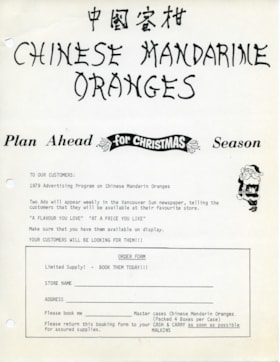
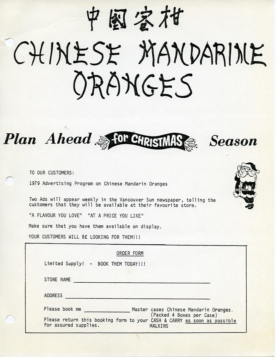
Advertising flyer and order form for Chinese mandarin oranges
https://search.heritageburnaby.ca/link/museumdescription14878
- Repository
- Burnaby Village Museum
- Date
- 1979
- Collection/Fonds
- Julie Lee and Cecil Lee family fonds
- Description Level
- Item
- Physical Description
- 1 p.
- Scope and Content
- Item consists of a one page advertising flyer and order form to customers of W.H. Malkins "1979 Advertising program on Chinese Mandarin Oranges". The flyer includes the title in English and Chinese "Chinese Mandarin Oranges".
- Repository
- Burnaby Village Museum
- Collection/Fonds
- Julie Lee and Cecil Lee family fonds
- Description Level
- Item
- Physical Description
- 1 p.
- Scope and Content
- Item consists of a one page advertising flyer and order form to customers of W.H. Malkins "1979 Advertising program on Chinese Mandarin Oranges". The flyer includes the title in English and Chinese "Chinese Mandarin Oranges".
- Subjects
- Agriculture - Fruit and Berries
- Foods
- Documentary Artifacts - Leaflets
- Buildings - Commercial - Grocery Stores
- Accession Code
- BV019.6.107
- Access Restriction
- No restrictions
- Reproduction Restriction
- May be restricted by third party rights
- Date
- 1979
- Media Type
- Textual Record
- Scan Resolution
- 600
- Scan Date
- 3-Nov-2020
- Scale
- 100
- Notes
- Title based on content of item
- Item is part of a scrapbook album created by Cecil Lee
Images
Agreement for sale of land between Joseph C. Armstrong and Jesse Love re District Lot 25
https://search.heritageburnaby.ca/link/museumdescription18788
- Repository
- Burnaby Village Museum
- Date
- 6 Oct. 1893
- Collection/Fonds
- Love family fonds
- Description Level
- Item
- Physical Description
- 1 p. of textual records + 1 plan : red and black ink on linen ; 16 x 8.5 cm
- Scope and Content
- Item consists of an Agreement for Sale of Land dated October 6, 1893 between Joseph C. Armstrong and Jesse Love for District Lot 25, Group one, New Westminster District and a small hand drawn plan showing District Lot 25, Cumberland Road and location of building. Land Agreement was registered Febru…
- Repository
- Burnaby Village Museum
- Collection/Fonds
- Love family fonds
- Description Level
- Item
- Physical Description
- 1 p. of textual records + 1 plan : red and black ink on linen ; 16 x 8.5 cm
- Scope and Content
- Item consists of an Agreement for Sale of Land dated October 6, 1893 between Joseph C. Armstrong and Jesse Love for District Lot 25, Group one, New Westminster District and a small hand drawn plan showing District Lot 25, Cumberland Road and location of building. Land Agreement was registered February 13, 1894.
- Accession Code
- BV992.26.8
- Access Restriction
- No restrictions
- Reproduction Restriction
- No known restrictions
- Date
- 6 Oct. 1893
- Media Type
- Textual Record
- Cartographic Material
- Notes
- Title based on contents of item
- Document dated Oct 6 1893; "ARTICLES OF AGREEMENT" between Joseph C. Armstrong and Jesse Love; one page, folded on buff, legal-sized paper with pink borders; black print; handwritten in faded brown ink; for a parcel of land in the New Westminster District, all that portion of Lot 25, Group I, from a point on the Easterly side 20 chains from the South Easterly corner, then from the South Easterly corner, then northerly and parallel with the Cumberland Road for 10 chains and 52 links, then southerly 10 chains, then Easterly 14 chains and 52 links, total 14 acres and 52/100; for $1161 in 17 instalments at 6% interest; signed by Jesse Love and J.C. Armstrong, witnessed by H.A. Eastman; two seals are missing, pink stains on paper; addition May 1900 signed by Jesse Love and H.A. Eastman; folds twice; when folded, panel showing is "AGREEMENT for Sale of Land." "on Cumberland road in Lot 25 Group I"; handwritten "H.A. Eastman" over printed "E.H. PORT & CO.", "REAL ESTATE BROKERS" "NEW WESTMINSTER BRITISH COLUMBIA"; back panel has blue stamping and pink additions, giving No. 546C, registered February 13, 1894, Charge Book Vol. 13, Folio 51, signed C.S. Corrigan? District Registrar; with hand-drawn plan on stained linen, pink ink with black additions, shows Cumberland Road and city limits.
A guide to Burnaby : the heart of Greater Vancouver
https://search.heritageburnaby.ca/link/museumlibrary6728
- Repository
- Burnaby Village Museum
- Collection
- Reference Collection
- Material Type
- Textual Record
- Call Number
- 971.133 BUR
- Place of Publication
- Burnaby, B.C.
- Publisher
- City of Burnaby
- Publication Date
- 2003
- Physical Description
- 1 map : ill ; 10 x 23 cm.
- Library Subject (LOC)
- Burnaby, B.C.
- Burnaby (B.C.)--Description and travel
- Burnaby (B.C.)--Geography
- Burnaby (B.C.)--Buildings, structures, etc.
Alfred Bingham fonds
https://search.heritageburnaby.ca/link/archivedescription97219
- Repository
- City of Burnaby Archives
- Date
- 1913-1971
- Collection/Fonds
- Alfred Bingham fonds
- Description Level
- Fonds
- Physical Description
- 4 cm. of textual records and 1 audio reel.
- Scope and Content
- Fonds consists of correspondence and literature pertaining to Alfred Bingham as well as an oral history tape provided by Alfred and his wife, M.J. "Ada" Bingham.
- Repository
- City of Burnaby Archives
- Date
- 1913-1971
- Collection/Fonds
- Alfred Bingham fonds
- Physical Description
- 4 cm. of textual records and 1 audio reel.
- Description Level
- Fonds
- Record No.
- MSS142
- Accession Number
- 2010-09
- Scope and Content
- Fonds consists of correspondence and literature pertaining to Alfred Bingham as well as an oral history tape provided by Alfred and his wife, M.J. "Ada" Bingham.
- History
- Alfred "Alf" Bingham was born in England in 1892 and moved to Canada in 1912. His first job in Canada was laying track for the Grand Trunk Pacific Railway (GTPR) from Edmonton to McBride in 1912. His second was in Vancouver at the Rat Portage Mill on False Creek, working on the Resaw machine. He quit after one week due to poor working conditions. After taking part in the 1919 Winnipeg General Strike as a delegate of the Retail and Mailorder Union (A.F.L.) on the Winnipeg Trades and Labour Council, Alfred moved to Burnaby where he and fellow Burnaby residents Angus McLean and Percy Little worked ten-hour days to build a shingle mill on the edge of Burnaby Lake for Simpson & Giberson. George Green, a carpenter and millwright (and author of “The History of Burnaby”), also helped in the construction of the mill. Alfred built his own home from lumber cut from the mill in the Lockdale area on Sherlock Street between Curtis Street and Kitchener Street. On April 10, 1920, Alfred married Mary Jane "Ada" Reynolds. Alfred and Mary Jane often took in foster children during their marriage. Due to her nursing experience, Ada was often called upon to deliver babies in the Burnaby area. The couple also had a dog named Bess. The Binghams were instrumental members of the Army of the Common Good, collecting vegetables and grains from growers in the area and even producing over 125 tons of vegetables from its own gardens to feed children and youth who were suffering from the lack of resources during the Depression. The Army was in operation for ten years and during that time, the members organised the credit union movement of British Columbia and drew up the Credit Union Act through the Vancouver Co-operative Council. They also started co-op stores and the Co-Op Wholesale Society. Alfred was also the Secretary of the Burnaby Housing Committee. In 1946, he became the Secretary of the North Burnaby Labour Progressive Party (LPP). Mary Jane died on August 9, 1969. Alfred died on April 29, 1979.
- Media Type
- Textual Record
- Sound Recording
- Creator
- Bingham, Alfred "Alf"
- Notes
- Title based on contents of fonds MSS142
Alfred Bingham papers
https://search.heritageburnaby.ca/link/archivedescription65600
- Repository
- City of Burnaby Archives
- Date
- 1938-1963
- Collection/Fonds
- Alfred Bingham fonds
- Description Level
- File
- Physical Description
- 1 cm. of textual records.
- Scope and Content
- File consists of Alfred Bingham’s notes on the lives of various Burnaby Pioneers as well as his own writtings; “The Stump Ranchers “ with a great deal of information on the history of the Army of the Common Good. Also included in the file is a series of stories of Alf Bingham’s first memories of mo…
- Repository
- City of Burnaby Archives
- Date
- 1938-1963
- Collection/Fonds
- Alfred Bingham fonds
- Physical Description
- 1 cm. of textual records.
- Description Level
- File
- Record No.
- MSS142-001
- Access Restriction
- Subject to FOIPPA
- Accession Number
- 2010-09
- Scope and Content
- File consists of Alfred Bingham’s notes on the lives of various Burnaby Pioneers as well as his own writtings; “The Stump Ranchers “ with a great deal of information on the history of the Army of the Common Good. Also included in the file is a series of stories of Alf Bingham’s first memories of moving to Burnaby; “I Arrive in Burnaby and We Build a Shingle Mill”, “We Build a Home and Dig a Well”, “What the Lochdale District Looked Like in 1919-20-21-22”,“Second Settlers in the Lochdale District”, “The Death of Mary Hawthorn”, “The Rum Runners and Bootleg Whiskey in Burnaby”, “Burnaby, North, South, East and West, 1892-1943”, “The Ice Age and other observations before Burnaby”, “Our House Burns Down” and “History of the Working People of Burnaby.”
- Media Type
- Textual Record
- Notes
- Title based on contents of file
Alfred Bingham subseries
https://search.heritageburnaby.ca/link/archivedescription57735
- Repository
- City of Burnaby Archives
- Date
- 1913-1971
- Collection/Fonds
- Burnaby Historical Society fonds
- Description Level
- Subseries
- Physical Description
- Photographs and other materials
- Scope and Content
- Subseries consists of photographs, correspondence and literature pertaining to Alfred Bingham.
- Repository
- City of Burnaby Archives
- Date
- 1913-1971
- Collection/Fonds
- Burnaby Historical Society fonds
- Subseries
- Alfred Bingham subseries
- Physical Description
- Photographs and other materials
- Description Level
- Subseries
- Accession Number
- BHS2007-04
- Scope and Content
- Subseries consists of photographs, correspondence and literature pertaining to Alfred Bingham.
- History
- Alfred "Alf" Bingham was born in England in 1892 and moved to Canada in 1912. His first job in Canada was laying track for the Grand Trunk Pacific Railway (GTPR) from Edmonton to McBride in 1912. His second was in Vancouver at the Rat Portage Mill on False Creek, working on the Resaw machine. He quit after one week due to poor working conditions. After taking part in the 1919 Winnipeg General Strike as a delegate of the Retail and Mailorder Union (A.F.L.) on the Winnipeg Trades and Labour Council, Alfred moved to Burnaby where he and fellow Burnaby residents Angus McLean and Percy Little worked ten-hour days to build a shingle mill on the edge of Burnaby Lake for Simpson & Giberson. George Green, a carpenter and millwright (and author of “The History of Burnaby”), also helped in the construction of the mill. Alfred built his own home from lumber cut from the mill in the Lockdale area on Sherlock Street between Curtis Street and Kitchener Street. On April 10, 1920, Alfred married Mary Jane "Ada" Reynolds. Alfred and Mary Jane often took in foster children during their marriage. Due to her nursing experience, Ada was often called upon to deliver babies in the Burnaby area. The couple also had a dog named Bess. The Binghams were instrumental members of the Army of the Common Good, collecting vegetables and grains from growers in the area and even producing over 125 tons of vegetables from its own gardens to feed children and youth who were suffering from the lack of resources during the Depression. The Army was in operation for ten years and during that time, the members organised the credit union movement of British Columbia and drew up the Credit Union Act through the Vancouver Co-operative Council. They also started co-op stores and the Co-Op Wholesale Society. Alfred was also the Secretary of the Burnaby Housing Committee. In 1946, he became the Secretary of the North Burnaby Labour Progressive Party (LPP). Mary Jane died on August 9, 1969. Alfred died on April 29, 1979.
- Media Type
- Textual Record
- Photograph
- Creator
- Bingham, Alfred "Alf"
- Notes
- Title based on contents of subseries
- MSS001, MSS142, and PC 010
![All Saints Church, [ca.1910] thumbnail](/media/hpo/_Data/_BVM_Cartographic_Material/2003/2003_0083_0046_001.jpg?width=280)
All Saints Church
https://search.heritageburnaby.ca/link/museumdescription11924
- Repository
- Burnaby Village Museum
- Date
- [ca.1910]
- Collection/Fonds
- Ronald G. Scobbie collection
- Description Level
- Item
- Physical Description
- 1 plan : black ink and watercol. on paper ; 30.45 x 30.5 cm
- Scope and Content
- Item consists of building insurance plan of "All Saints Church / Lot "A" BK 29 DL 98 GP1 N.W.D.". Watling Street is idenfied to the north of the church building and Royal Oak Avenue to the west.
- Repository
- Burnaby Village Museum
- Collection/Fonds
- Ronald G. Scobbie collection
- Description Level
- Item
- Physical Description
- 1 plan : black ink and watercol. on paper ; 30.45 x 30.5 cm
- Material Details
- Scale 1 inch = 20 feet
- Scope and Content
- Item consists of building insurance plan of "All Saints Church / Lot "A" BK 29 DL 98 GP1 N.W.D.". Watling Street is idenfied to the north of the church building and Royal Oak Avenue to the west.
- Subjects
- Buildings - Religious - Churches
- Accession Code
- BV003.83.46
- Access Restriction
- No restrictions
- Reproduction Restriction
- No known restrictions
- Date
- [ca.1910]
- Media Type
- Cartographic Material
- Scan Resolution
- 600
- Scan Date
- 15-Jan-2021
- Scale
- 100
- Notes
- Transcribed title
- Note in pencil on verso reads: ""All Saints Church / Lot "A" BK 29 DL 98 / Scale 1 inch = 20 feet"
- Note in balck in on verso reads: "3704"
Images
![All Saints Church, [ca.1910] thumbnail](/media/hpo/_Data/_BVM_Cartographic_Material/2003/2003_0083_0046_001.jpg)
Alvin Burtch papers
https://search.heritageburnaby.ca/link/archivedescription58347
- Repository
- City of Burnaby Archives
- Date
- 1923-1946
- Collection/Fonds
- Burnaby Historical Society fonds
- Description Level
- File
- Physical Description
- 1 file of textual records
- Scope and Content
- File consists of papers pertaining to the purchase of the lot and building of a house at 1869 18th Avenue in Burnaby, including the original Agreement of Sale between Mabel Carson and Alvin Burtch.
- Repository
- City of Burnaby Archives
- Date
- 1923-1946
- Collection/Fonds
- Burnaby Historical Society fonds
- Subseries
- Alvin Burtch subseries
- Physical Description
- 1 file of textual records
- Description Level
- File
- Record No.
- MSS067-001
- Accession Number
- BHS1992-02
- Scope and Content
- File consists of papers pertaining to the purchase of the lot and building of a house at 1869 18th Avenue in Burnaby, including the original Agreement of Sale between Mabel Carson and Alvin Burtch.
- Media Type
- Textual Record
- Notes
- Title based on contents of file
Andrew Johnson subseries
https://search.heritageburnaby.ca/link/archivedescription4
- Repository
- City of Burnaby Archives
- Date
- [1880]-[1940]
- Collection/Fonds
- Burnaby Historical Society fonds
- Description Level
- Subseries
- Physical Description
- Photographs and drawings
- Scope and Content
- Subseries consists of photographs and drawings of members of the Johnson family and their home.
- Repository
- City of Burnaby Archives
- Date
- [1880]-[1940]
- Collection/Fonds
- Burnaby Historical Society fonds
- Subseries
- Andrew Johnson subseries
- Physical Description
- Photographs and drawings
- Description Level
- Subseries
- Access Restriction
- No restrictions
- Accession Number
- BHS1990-10
- BHS1997-16
- Scope and Content
- Subseries consists of photographs and drawings of members of the Johnson family and their home.
- History
- Andrew Martin Johnson was born in Norway in 1861 and immigrated to Vancouver, British Columbia in 1886. His wife Margaret Sloane was born in Ireland. Margaret and Andrew Johnson's eldest child, Edward Sloane, was born June 10, 1901 but did not survive infancy. Their second child, Andrew Sloane, was born in 1906. Andrew Martin was a major landowner in Burnaby, at one time owning each of the four corners of Royal Oak and Kingsway and many of the adjacent properties. He made his fortune as a partner in the firm of Atkins & Johnson, a leading transportation company in Vancouver which later became the Mainland Transfer Company. In 1910, Andrew Martin purchased Burnaby's Royal Oak Hotel. He soon acquired the property on the opposite corner to build their family home, called "Glenedward" after their eldest son. He owned and operated the Royal Oak Hotel until his death on September 18, 1934. In 1943 Margaret sold Glenedward. The building has since been converted twice: first into the Royal Oak Funeral Chapel and then into the Johnson House Korean Restaurant. Andrew Sloane Johnson attended Kingsway West School and Britannia High School before earning a Bachelor's of Business Administration at the University of Washington in 1930. He lived at Glenedward until moving to Washington for school.
- Media Type
- Photograph
- Textual Record
- Creator
- Johnson, Andrew Martin
- Notes
- Title based on contents of subseries
- PC244, PC335
![Anglican Church, [ca.1910] thumbnail](/media/hpo/_Data/_BVM_Cartographic_Material/2003/2003_0083_0043_001.jpg?width=280)
Anglican Church
https://search.heritageburnaby.ca/link/museumdescription11921
- Repository
- Burnaby Village Museum
- Date
- [ca.1910]
- Collection/Fonds
- Ronald G. Scobbie collection
- Description Level
- Item
- Physical Description
- 1 plan : black ink and watercol. on paper ; 30.45 x 30.5 cm
- Scope and Content
- Item consists of building insurance plan of "Anglican Church / Lot 2 BK 37 DL69, GP.1, N.W.D. (15th Ave. (Dominion) is identified to the north of Lots 1, 2 and 3).
- Repository
- Burnaby Village Museum
- Collection/Fonds
- Ronald G. Scobbie collection
- Description Level
- Item
- Physical Description
- 1 plan : black ink and watercol. on paper ; 30.45 x 30.5 cm
- Material Details
- Scale 1 inch = 20 feet
- Scope and Content
- Item consists of building insurance plan of "Anglican Church / Lot 2 BK 37 DL69, GP.1, N.W.D. (15th Ave. (Dominion) is identified to the north of Lots 1, 2 and 3).
- Subjects
- Buildings - Religious - Churches
- Accession Code
- BV003.83.43
- Access Restriction
- No restrictions
- Reproduction Restriction
- No known restrictions
- Date
- [ca.1910]
- Media Type
- Cartographic Material
- Scan Resolution
- 600
- Scan Date
- 15-Jan-2021
- Scale
- 100
- Notes
- Transcribed title
- Note in pencil on verso reads: "Anglican Church / Lot 2 Bk 37 DL69 / 1"=20' "
- Note in balck in on verso reads: "3704"
Images
![Anglican Church, [ca.1910] thumbnail](/media/hpo/_Data/_BVM_Cartographic_Material/2003/2003_0083_0043_001.jpg)

Armstrong Street School site
https://search.heritageburnaby.ca/link/museumdescription11133
- Repository
- Burnaby Village Museum
- Date
- 1915
- Collection/Fonds
- Ronald G. Scobbie collection
- Description Level
- Item
- Physical Description
- 1 survey plan : blueprint on paper ; 56 x 54 cm
- Scope and Content
- Survey plan of "Armstrong Street School Site / Burnaby Municipality" "Being a 2 acre portion of Lot 13 Group 1, & according to map 1722 which shows this as Lot E. Block 2 of subdivision of a portion, of Lot 13, Group 1, New Westminster District".
- Repository
- Burnaby Village Museum
- Collection/Fonds
- Ronald G. Scobbie collection
- Description Level
- Item
- Physical Description
- 1 survey plan : blueprint on paper ; 56 x 54 cm
- Material Details
- Scale 40 feet = 1 inch
- Scope and Content
- Survey plan of "Armstrong Street School Site / Burnaby Municipality" "Being a 2 acre portion of Lot 13 Group 1, & according to map 1722 which shows this as Lot E. Block 2 of subdivision of a portion, of Lot 13, Group 1, New Westminster District".
- Creator
- Burnett, Geoffrey K.
- Subjects
- Buildings - Schools
- Names
- Armstrong Avenue School
- Responsibility
- Burnett & McGugan, Engineers and Surveyors
- Geographic Access
- Armstrong Avenue
- Street Address
- 8757 Armstrong Avenue
- Accession Code
- BV003.83.12
- Access Restriction
- No restrictions
- Reproduction Restriction
- No known restrictions
- Date
- 1915
- Media Type
- Cartographic Material
- Historic Neighbourhood
- East Burnaby (Historic Neighbourhood)
- Planning Study Area
- Cariboo-Armstrong Area
- Scan Resolution
- 440
- Scan Date
- 22-Dec-2020
- Scale
- 100
- Notes
- Title based on contents of plan
- Note in black ink on verso of plan reads: "1746"
- Oath on plan reads: "I, Geoffrey K. Burnett...and did personally superintend the survey represented..." "Completed on the 18th day of March 1915"; signed by Geoffrey K. Burnett and notarized by "K.A. Eastman", sworn "...19th day of April 1915"; "Burnett and McGugan., B.C. Land Surveyors. Etc.. New Westminster, B.C.."
Zoomable Images

Arts Centre Building Committee
https://search.heritageburnaby.ca/link/archivedescription56647
- Repository
- City of Burnaby Archives
- Date
- 1987-1988
- Collection/Fonds
- Burnaby Historical Society fonds
- Description Level
- File
- Physical Description
- Textual record
- Repository
- City of Burnaby Archives
- Date
- 1987-1988
- Collection/Fonds
- Burnaby Historical Society fonds
- Subseries
- Burnaby Arts Council subseries
- Physical Description
- Textual record
- Description Level
- File
- Record No.
- 40073
- Accession Number
- BHS1998-06
- Media Type
- Textual Record

Barnet School site
https://search.heritageburnaby.ca/link/museumdescription11140
- Repository
- Burnaby Village Museum
- Date
- May 27, 1915
- Collection/Fonds
- Ronald G. Scobbie collection
- Description Level
- Item
- Physical Description
- 1 survey plan : blueprint on paper ; 56 x 54 cm
- Scope and Content
- Survey plan of "Barnet School Site / Burnaby Municipality" "Being a portion of the west half of lot / 214, Group 1 / New Westminster District”.
- Repository
- Burnaby Village Museum
- Collection/Fonds
- Ronald G. Scobbie collection
- Description Level
- Item
- Physical Description
- 1 survey plan : blueprint on paper ; 56 x 54 cm
- Material Details
- Scale 40 feet = 1 inch
- Scope and Content
- Survey plan of "Barnet School Site / Burnaby Municipality" "Being a portion of the west half of lot / 214, Group 1 / New Westminster District”.
- Creator
- McGugan, Donald Johnston
- Subjects
- Buildings - Schools
- Names
- Barnet School
- Responsibility
- Burnett & McGugan, Engineers and Surveyors
- Geographic Access
- Barnet Road
- Street Address
- 7820 Barnet Road
- Accession Code
- BV003.83.19
- Access Restriction
- No restrictions
- Reproduction Restriction
- No known restrictions
- Date
- May 27, 1915
- Media Type
- Cartographic Material
- Historic Neighbourhood
- Barnet (Historic Neighbourhood)
- Planning Study Area
- Burnaby Mountain Area
- Scan Resolution
- 440
- Scan Date
- 22-Dec-2020
- Scale
- 100
- Notes
- Title based on contents of plan
- handwritten on back "Burnaby Schools" "23R" twice, "1783"
- Oath on plan reads: "I, D.J. McGugan...and did personally superintend the survey..." "completed on the 27th day of May 1915"; signed by D.J. McGugan, notarized by "Walter Edmonds" "sworn "...29th day of May 1915" "Burnett and McGugan" "B.C. Land Surveyors Etc. New Westminster, B.C.";
Zoomable Images

B.C. Electric Railway - Building line 6th Street, Edmonds Road, Queens Park
https://search.heritageburnaby.ca/link/archivedescription398
- Repository
- City of Burnaby Archives
- Date
- 1911
- Collection/Fonds
- City Council and Office of the City Clerk fonds
- Description Level
- File
- Physical Description
- Textual record
- Scope and Content
- File contains correspondence related to the rebuilding of rail lines from Queens Park to Edmonds, and the Edmonds Road and 6th Street tracks.
- Repository
- City of Burnaby Archives
- Date
- 1911
- Collection/Fonds
- City Council and Office of the City Clerk fonds
- Physical Description
- Textual record
- Description Level
- File
- Record No.
- 2098
- Accession Number
- 2001-02
- Scope and Content
- File contains correspondence related to the rebuilding of rail lines from Queens Park to Edmonds, and the Edmonds Road and 6th Street tracks.
- Media Type
- Textual Record
B.C. home canning and fruit recipe booklet
https://search.heritageburnaby.ca/link/museumlibrary7434
- Repository
- Burnaby Village Museum
- Author
- B.C. Tree Fruits Limited
- Publication Date
- 1950
- Call Number
- 641.42 BCH
- Repository
- Burnaby Village Museum
- Collection
- Special Collection
- Material Type
- Textual Record
- Accession Code
- BV019.37.5
- Call Number
- 641.42 BCH
- Author
- B.C. Tree Fruits Limited
- Place of Publication
- [Kelowna, B.C.]
- Publisher
- B.C. Tree Fruits Ltd.
- Publication Date
- 1950
- Physical Description
- 16 p. ; 22 cm.
- Library Subject (LOC)
- Canning and preserving
- Cookbooks--British Columbia
- Cooking--Canada
- Fruit--Preservation
- Cooking--British Columbia
- Object History
- Elmer Wilson Martin was a professional engineer who lived much of his life in Burnaby. He married Ellen Renetta "Reta" (Boyd) Martin in approx. 1930 and the couple moved to Burnaby in 1931 for him to attend UBC. He later enlisted in the RCAF during WWII where he served as a pilot and wing commander. Elmer ran Martin's Auto Villa at 6604 East Hastings Street (later 6574 East Hastings Street) and was heavily involved in local Burnaby politics and with the North Burnaby Board of Trade. The donor states that he ran for Burnaby mayor in 1959 and also donated land to S.F.U. in the late 1960's. He had many businesses throughout his life including Paneloc Buildings, a pre-fab building manufacturing company. His last position was as Director with the construction company Webb & Knapp Canada Ltd.
- Notes
- "Edited by one of Canada's foremost home cooking experts" -- cover "Sales agents for Canada's finer fresh fruits