Narrow Results By
Person / Organization
- All Saints Anglican Church 1
- Broadview Presbyterian Church 1
- Dundonald United Church 1
- East Burnaby United Church, 1925-2008 1
- Love, Jesse, 1849-1928 5
- Love, Martha Leonard, 1858-1920 5
- ʷməθkʷəy̓əm (Musqueam) 2
- Seaforth School 1
- St. Alban's Anglican Church 1
- Stanley, Esther Love 5
- St. Helen's Catholic Church 1
- St. John the Divine Anglican Church 1
Oral history interview with Esther Stanley May 5, 1988 - Track 1
https://search.heritageburnaby.ca/link/museumdescription9836
- Repository
- Burnaby Village Museum
- Date
- 1925 (interview content), interviewed May 5, 1988
- Collection/Fonds
- Burnaby Village Museum fonds
- Description Level
- Item
- Physical Description
- 1 audio cassette (0:08:21 min)
- Scope and Content
- Track 1: Esther talks about the house as she remembers it from her childhood, describing the additions. Jim asks her about the furnishings of the hallway, parlour and kitchen and the contents of the pantry, and they discuss the house’s bathrooms.
- Repository
- Burnaby Village Museum
- Collection/Fonds
- Burnaby Village Museum fonds
- Series
- Jesse Love farmhouse series
- Description Level
- Item
- Physical Description
- 1 audio cassette (0:08:21 min)
- Material Details
- Interviewer: Jim Wolf Interviewee: Esther Stanley Location of Interview: not known Interview Date: May 5, 1988 Total Length of all Tracks: 36:21 Total Number of Tracks: 5
- Scope and Content
- Track 1: Esther talks about the house as she remembers it from her childhood, describing the additions. Jim asks her about the furnishings of the hallway, parlour and kitchen and the contents of the pantry, and they discuss the house’s bathrooms.
- History
- Jim Wolf talks about Love Farmhouse with Esther Stanley, daughter of Jesse and Martha Love. They discuss the property, and the furnishings, decoration and amenities of the house as she remembers them. Esther’s recollections were to be used as a resource for redecorating and refurnishing the house as it was in 1925 for its use as an exhibit at the Burnaby Village Museum. Esther’s daughters are also present at the interview.
- Creator
- Wolf, Jim
- Accession Code
- BV018.41.47
- Access Restriction
- No restrictions
- Reproduction Restriction
- May be restricted by third party rights
- Date
- 1925 (interview content), interviewed May 5, 1988
- Media Type
- Sound Recording
- Textual Record
- Related Material
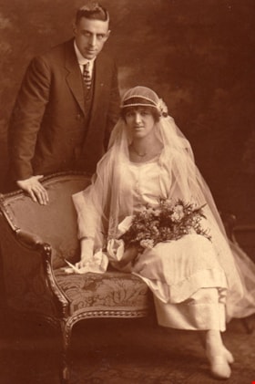
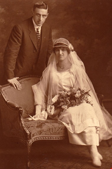
- Wedding Portrait of Frank Charles Stanley and Esther Love Stanley, 1921. Item: BV015.40.41
- Notes
- Title based on content of file
- 4 pages of interview notes accompanying oral history recording
Images
Audio Tracks
Oral history interview with Esther Stanley May 5, 1988 - Track 1, 1925 (interview content), interviewed May 5, 1988
Oral history interview with Esther Stanley May 5, 1988 - Track 1, 1925 (interview content), interviewed May 5, 1988
https://search.heritageburnaby.ca/media/hpo/_Data/_BVM_Sound_Recordings/Oral_Histories/2018_0041_0047_001.mp3
Oral history interview with Esther Stanley May 5, 1988 - Track 2
https://search.heritageburnaby.ca/link/museumdescription10400
- Repository
- Burnaby Village Museum
- Date
- 1925 (interview content), interviewed May 5, 1988
- Collection/Fonds
- Burnaby Village Museum fonds
- Description Level
- Item
- Physical Description
- 1 audio cassette (0:07:50 min) + 4 p. of textual records
- Scope and Content
- Track 2: This portion of the recording pertains to the property, Esther’s schooling, and the other members of the household. Esther recalls the house’s water supply system and Jim asks her about the gardens. They talk about the outbuildings and livestock. Esther also talks about the schools she att…
- Repository
- Burnaby Village Museum
- Collection/Fonds
- Burnaby Village Museum fonds
- Series
- Jesse Love farmhouse series
- Description Level
- Item
- Physical Description
- 1 audio cassette (0:07:50 min) + 4 p. of textual records
- Material Details
- Interviewer: Jim Wolf Interviewee: Esther Stanley Location of Interview: not known Interview Date: May 5, 1988 Total Length of all Tracks: 36:21 Total Number of Tracks: 5
- Scope and Content
- Track 2: This portion of the recording pertains to the property, Esther’s schooling, and the other members of the household. Esther recalls the house’s water supply system and Jim asks her about the gardens. They talk about the outbuildings and livestock. Esther also talks about the schools she attended. Jim asks about the family’s Christmas traditions, Esther’s siblings, the deaths of family members in the house, and Jesse Love’s work and means of transport.
- History
- Jim Wolf talks about Love Farmhouse with Esther Stanley, daughter of Jesse and Martha Love. They discuss the property, and the furnishings, decoration and amenities of the house as she remembers them. Esther’s recollections were to be used as a resource for redecorating and refurnishing the house as it was in 1925 for its use as an exhibit at the Burnaby Village Museum. Esther’s daughters are also present at the interview.
- Creator
- Wolf, Jim
- Accession Code
- BV018.41.47
- Access Restriction
- No restrictions
- Reproduction Restriction
- May be restricted by third party rights
- Date
- 1925 (interview content), interviewed May 5, 1988
- Media Type
- Sound Recording
- Textual Record
- Notes
- Title based on content of file
- 4 pages of interview notes accompanying oral history recording
Images
Audio Tracks
Oral history interview with Esther Stanley May 5, 1988 - Track 2, 1925 (interview content), interviewed May 5, 1988
Oral history interview with Esther Stanley May 5, 1988 - Track 2, 1925 (interview content), interviewed May 5, 1988
https://search.heritageburnaby.ca/media/hpo/_Data/_BVM_Sound_Recordings/Oral_Histories/2018_0041_0047_002.mp3
Oral history interview with Esther Stanley May 5, 1988 - Track 3
https://search.heritageburnaby.ca/link/museumdescription10401
- Repository
- Burnaby Village Museum
- Date
- 1925 (interview content), interviewed May 5, 1988
- Collection/Fonds
- Burnaby Village Museum fonds
- Description Level
- Item
- Physical Description
- 1 audio cassette (0:06:20 min) + 4 p. of textual records
- Scope and Content
- Track 3: Esther recalls learning to drive, and Jim asks about her father’s pipe collection and the heating arrangements of the house. They discuss the family’s music and entertainments, and the furnishings and decoration of ground floor rooms. Esther mentions her job picking fruit. Jim shows the wo…
- Repository
- Burnaby Village Museum
- Collection/Fonds
- Burnaby Village Museum fonds
- Series
- Jesse Love farmhouse series
- Description Level
- Item
- Physical Description
- 1 audio cassette (0:06:20 min) + 4 p. of textual records
- Material Details
- Interviewer: Jim Wolf Interviewee: Esther Stanley Location of Interview: not known Interview Date: May 5, 1988 Total Length of all Tracks: 36:21 Total Number of Tracks: 5
- Scope and Content
- Track 3: Esther recalls learning to drive, and Jim asks about her father’s pipe collection and the heating arrangements of the house. They discuss the family’s music and entertainments, and the furnishings and decoration of ground floor rooms. Esther mentions her job picking fruit. Jim shows the women photographs from the archives, and Esther identifies people. Jim asks about the dates of the photos and the additions to the house.
- History
- Jim Wolf talks about Love Farmhouse with Esther Stanley, daughter of Jesse and Martha Love. They discuss the property, and the furnishings, decoration and amenities of the house as she remembers them. Esther’s recollections were to be used as a resource for redecorating and refurnishing the house as it was in 1925 for its use as an exhibit at the Burnaby Village Museum. Esther’s daughters are also present at the interview.
- Creator
- Wolf, Jim
- Accession Code
- BV018.41.47
- Access Restriction
- No restrictions
- Reproduction Restriction
- May be restricted by third party rights
- Date
- 1925 (interview content), interviewed May 5, 1988
- Media Type
- Sound Recording
- Textual Record
- Notes
- Title based on content of file
- 4 pages of interview notes accompanying oral history recording
Images
Audio Tracks
Oral history interview with Esther Stanley May 5, 1988 - Track 3, 1925 (interview content), interviewed May 5, 1988
Oral history interview with Esther Stanley May 5, 1988 - Track 3, 1925 (interview content), interviewed May 5, 1988
https://search.heritageburnaby.ca/media/hpo/_Data/_BVM_Sound_Recordings/Oral_Histories/2018_0041_0047_003.mp3
Oral history interview with Esther Stanley May 5, 1988 - Track 4
https://search.heritageburnaby.ca/link/museumdescription10402
- Repository
- Burnaby Village Museum
- Date
- 1925 (interview content), interviewed May 5, 1988
- Collection/Fonds
- Burnaby Village Museum fonds
- Description Level
- Item
- Physical Description
- 1 audio cassette (0:06:28 min) + 4 p. of textual records
- Scope and Content
- Track 4: In this portion of the recording, Jim shows more photographs to Esther, including recent ones, and she identifies areas of the gardens and grounds, and outbuildings. They also look at interior photos and discuss materials and finishes. Esther notes that her brother George helped with the a…
- Repository
- Burnaby Village Museum
- Collection/Fonds
- Burnaby Village Museum fonds
- Series
- Jesse Love farmhouse series
- Description Level
- Item
- Physical Description
- 1 audio cassette (0:06:28 min) + 4 p. of textual records
- Material Details
- Interviewer: Jim Wolf Interviewee: Esther Stanley Location of Interview: not known Interview Date: May 5, 1988 Total Length of all Tracks: 36:21 Total Number of Tracks: 5
- Scope and Content
- Track 4: In this portion of the recording, Jim shows more photographs to Esther, including recent ones, and she identifies areas of the gardens and grounds, and outbuildings. They also look at interior photos and discuss materials and finishes. Esther notes that her brother George helped with the additions to the house and interiors.
- History
- Jim Wolf talks about Love Farmhouse with Esther Stanley, daughter of Jesse and Martha Love. They discuss the property, and the furnishings, decoration and amenities of the house as she remembers them. Esther’s recollections were to be used as a resource for redecorating and refurnishing the house as it was in 1925 for its use as an exhibit at the Burnaby Village Museum. Esther’s daughters are also present at the interview.
- Creator
- Wolf, Jim
- Accession Code
- BV018.41.47
- Access Restriction
- No restrictions
- Reproduction Restriction
- May be restricted by third party rights
- Date
- 1925 (interview content), interviewed May 5, 1988
- Media Type
- Sound Recording
- Textual Record
- Notes
- Title based on content of file
- 4 pages of interview notes accompanying oral history recording
Images
Audio Tracks
Oral history interview with Esther Stanley May 5, 1988 - Track 4, 1925 (interview content), interviewed May 5, 1988
Oral history interview with Esther Stanley May 5, 1988 - Track 4, 1925 (interview content), interviewed May 5, 1988
https://search.heritageburnaby.ca/media/hpo/_Data/_BVM_Sound_Recordings/Oral_Histories/2018_0041_0047_004.mp3
Oral history interview with Esther Stanley May 5, 1988 - Track 5
https://search.heritageburnaby.ca/link/museumdescription10403
- Repository
- Burnaby Village Museum
- Date
- 1925 (interview content), interviewed May 5, 1988
- Collection/Fonds
- Burnaby Village Museum fonds
- Description Level
- Item
- Physical Description
- 1 audio cassette (0:07:22 min) + 4 p. of textual records
- Scope and Content
- Track 5: Esther looks at more of the recent photographs, and talks about trees on the property and details of interiors and exteriors of the house. Jim asks about the cellar and the reservoir, and they discuss the porch and its furnishings.
- Repository
- Burnaby Village Museum
- Collection/Fonds
- Burnaby Village Museum fonds
- Series
- Jesse Love farmhouse series
- Description Level
- Item
- Physical Description
- 1 audio cassette (0:07:22 min) + 4 p. of textual records
- Material Details
- Interviewer: Jim Wolf Interviewee: Esther Stanley Location of Interview: not known Interview Date: May 5, 1988 Total Length of all Tracks: 36:21 Total Number of Tracks: 5
- Scope and Content
- Track 5: Esther looks at more of the recent photographs, and talks about trees on the property and details of interiors and exteriors of the house. Jim asks about the cellar and the reservoir, and they discuss the porch and its furnishings.
- History
- Jim Wolf talks about Love Farmhouse with Esther Stanley, daughter of Jesse and Martha Love. They discuss the property, and the furnishings, decoration and amenities of the house as she remembers them. Esther’s recollections were to be used as a resource for redecorating and refurnishing the house as it was in 1925 for its use as an exhibit at the Burnaby Village Museum. Esther’s daughters are also present at the interview.
- Creator
- Wolf, Jim
- Accession Code
- BV018.41.47
- Access Restriction
- No restrictions
- Reproduction Restriction
- May be restricted by third party rights
- Date
- 1925 (interview content), interviewed May 5, 1988
- Media Type
- Sound Recording
- Textual Record
- Notes
- Title based on content of file
- 4 pages of interview notes accompanying oral history recording
Images
Audio Tracks
Oral history interview with Esther Stanley May 5, 1988 - Track 5, 1925 (interview content), interviewed May 5, 1988
Oral history interview with Esther Stanley May 5, 1988 - Track 5, 1925 (interview content), interviewed May 5, 1988
https://search.heritageburnaby.ca/media/hpo/_Data/_BVM_Sound_Recordings/Oral_Histories/2018_0041_0047_005.mp3![All Saints Church, [ca.1910] thumbnail](/media/hpo/_Data/_BVM_Cartographic_Material/2003/2003_0083_0046_001.jpg?width=280)
All Saints Church
https://search.heritageburnaby.ca/link/museumdescription11924
- Repository
- Burnaby Village Museum
- Date
- [ca.1910]
- Collection/Fonds
- Ronald G. Scobbie collection
- Description Level
- Item
- Physical Description
- 1 plan : black ink and watercol. on paper ; 30.45 x 30.5 cm
- Scope and Content
- Item consists of building insurance plan of "All Saints Church / Lot "A" BK 29 DL 98 GP1 N.W.D.". Watling Street is idenfied to the north of the church building and Royal Oak Avenue to the west.
- Repository
- Burnaby Village Museum
- Collection/Fonds
- Ronald G. Scobbie collection
- Description Level
- Item
- Physical Description
- 1 plan : black ink and watercol. on paper ; 30.45 x 30.5 cm
- Material Details
- Scale 1 inch = 20 feet
- Scope and Content
- Item consists of building insurance plan of "All Saints Church / Lot "A" BK 29 DL 98 GP1 N.W.D.". Watling Street is idenfied to the north of the church building and Royal Oak Avenue to the west.
- Subjects
- Buildings - Religious - Churches
- Accession Code
- BV003.83.46
- Access Restriction
- No restrictions
- Reproduction Restriction
- No known restrictions
- Date
- [ca.1910]
- Media Type
- Cartographic Material
- Scan Resolution
- 600
- Scan Date
- 15-Jan-2021
- Scale
- 100
- Notes
- Transcribed title
- Note in pencil on verso reads: ""All Saints Church / Lot "A" BK 29 DL 98 / Scale 1 inch = 20 feet"
- Note in balck in on verso reads: "3704"
Images
![All Saints Church, [ca.1910] thumbnail](/media/hpo/_Data/_BVM_Cartographic_Material/2003/2003_0083_0046_001.jpg)
![Anglican Church, [ca.1910] thumbnail](/media/hpo/_Data/_BVM_Cartographic_Material/2003/2003_0083_0043_001.jpg?width=280)
Anglican Church
https://search.heritageburnaby.ca/link/museumdescription11921
- Repository
- Burnaby Village Museum
- Date
- [ca.1910]
- Collection/Fonds
- Ronald G. Scobbie collection
- Description Level
- Item
- Physical Description
- 1 plan : black ink and watercol. on paper ; 30.45 x 30.5 cm
- Scope and Content
- Item consists of building insurance plan of "Anglican Church / Lot 2 BK 37 DL69, GP.1, N.W.D. (15th Ave. (Dominion) is identified to the north of Lots 1, 2 and 3).
- Repository
- Burnaby Village Museum
- Collection/Fonds
- Ronald G. Scobbie collection
- Description Level
- Item
- Physical Description
- 1 plan : black ink and watercol. on paper ; 30.45 x 30.5 cm
- Material Details
- Scale 1 inch = 20 feet
- Scope and Content
- Item consists of building insurance plan of "Anglican Church / Lot 2 BK 37 DL69, GP.1, N.W.D. (15th Ave. (Dominion) is identified to the north of Lots 1, 2 and 3).
- Subjects
- Buildings - Religious - Churches
- Accession Code
- BV003.83.43
- Access Restriction
- No restrictions
- Reproduction Restriction
- No known restrictions
- Date
- [ca.1910]
- Media Type
- Cartographic Material
- Scan Resolution
- 600
- Scan Date
- 15-Jan-2021
- Scale
- 100
- Notes
- Transcribed title
- Note in pencil on verso reads: "Anglican Church / Lot 2 Bk 37 DL69 / 1"=20' "
- Note in balck in on verso reads: "3704"
Images
![Anglican Church, [ca.1910] thumbnail](/media/hpo/_Data/_BVM_Cartographic_Material/2003/2003_0083_0043_001.jpg)
![Broadview Presbyterian Church, [ca.1910] thumbnail](/media/hpo/_Data/_BVM_Cartographic_Material/2003/2003_0083_0049_001.jpg?width=280)
Broadview Presbyterian Church
https://search.heritageburnaby.ca/link/museumdescription11927
- Repository
- Burnaby Village Museum
- Date
- [ca.1910]
- Collection/Fonds
- Ronald G. Scobbie collection
- Description Level
- Item
- Physical Description
- 1 plan : black ink and watercol. on paper ; 30.45 x 30.5 cm
- Scope and Content
- Item consists of building insurance plan of "Broadview Presbyterian Church / Lot 6, BK 31, DL 69 / GP1 N.W.D." . Fourteenth Avenue (Manor) is identified to the north and Douglas Ave. to the east.
- Repository
- Burnaby Village Museum
- Collection/Fonds
- Ronald G. Scobbie collection
- Description Level
- Item
- Physical Description
- 1 plan : black ink and watercol. on paper ; 30.45 x 30.5 cm
- Material Details
- Scale 1 inch = 20 feet
- Scope and Content
- Item consists of building insurance plan of "Broadview Presbyterian Church / Lot 6, BK 31, DL 69 / GP1 N.W.D." . Fourteenth Avenue (Manor) is identified to the north and Douglas Ave. to the east.
- Subjects
- Buildings - Religious - Churches
- Accession Code
- BV003.83.49
- Access Restriction
- No restrictions
- Reproduction Restriction
- No known restrictions
- Date
- [ca.1910]
- Media Type
- Cartographic Material
- Scan Resolution
- 600
- Scan Date
- 15-Jan-2021
- Scale
- 100
- Notes
- Transcribed title
- Note in pencil on verso reads: "Broadview Presbyterian Church / Lot 6, BK 31, DL 69 / 1" = 20' "
- Note in balck in on verso reads: "3704"
Images
![Broadview Presbyterian Church, [ca.1910] thumbnail](/media/hpo/_Data/_BVM_Cartographic_Material/2003/2003_0083_0049_001.jpg)
![Dundonald United Church, [ca.1910] thumbnail](/media/hpo/_Data/_BVM_Cartographic_Material/2003/2003_0083_0052_001.jpg?width=280)
Dundonald United Church
https://search.heritageburnaby.ca/link/museumdescription11930
- Repository
- Burnaby Village Museum
- Date
- [ca.1910]
- Collection/Fonds
- Ronald G. Scobbie collection
- Description Level
- Item
- Physical Description
- 1 plan : black ink and watercol. on paper ; 30.45 x 30.5 cm
- Scope and Content
- Item consists of a building insurance plan of "Dundonald United Church / Lots 9, 10 BK 28 DL 159 GP 1 / N.W.D.". Clinton Street is identified to the north of Lots nine and ten.
- Repository
- Burnaby Village Museum
- Collection/Fonds
- Ronald G. Scobbie collection
- Description Level
- Item
- Physical Description
- 1 plan : black ink and watercol. on paper ; 30.45 x 30.5 cm
- Material Details
- Scale 1 inch = 20 feet
- Scope and Content
- Item consists of a building insurance plan of "Dundonald United Church / Lots 9, 10 BK 28 DL 159 GP 1 / N.W.D.". Clinton Street is identified to the north of Lots nine and ten.
- Subjects
- Buildings - Religious - Churches
- Names
- Dundonald United Church
- Accession Code
- BV003.83.52
- Access Restriction
- No restrictions
- Reproduction Restriction
- No known restrictions
- Date
- [ca.1910]
- Media Type
- Cartographic Material
- Scan Resolution
- 600
- Scan Date
- 15-Jan-2021
- Scale
- 100
- Notes
- Transcribed title
- Note in pencil on verso reads: "_ _Church / Lots 9 & 10 BK 28 DL 159 / 1" = 20' "
- Note in black ink on verso reads: "3704"
Images
![Dundonald United Church, [ca.1910] thumbnail](/media/hpo/_Data/_BVM_Cartographic_Material/2003/2003_0083_0052_001.jpg)
![East Burnaby United Church, [ca.1925] thumbnail](/media/hpo/_Data/_BVM_Cartographic_Material/2003/2003_0083_0054_001.jpg?width=280)
East Burnaby United Church
https://search.heritageburnaby.ca/link/museumdescription11932
- Repository
- Burnaby Village Museum
- Date
- [ca.1925]
- Collection/Fonds
- Ronald G. Scobbie collection
- Description Level
- Item
- Physical Description
- 1 plan : black ink and watercol. on paper ; 30.45 x 30.5 cm
- Scope and Content
- Item consists of a building insurance plan of "East Burnaby United Church / Lot 1 BK 2 south Part DL 28 GP 1 N.W.D.". Twelfth Avenue is identified to the north and Douglas Road to the west.
- Repository
- Burnaby Village Museum
- Collection/Fonds
- Ronald G. Scobbie collection
- Description Level
- Item
- Physical Description
- 1 plan : black ink and watercol. on paper ; 30.45 x 30.5 cm
- Material Details
- Scale 1 inch = 20 feet
- Scope and Content
- Item consists of a building insurance plan of "East Burnaby United Church / Lot 1 BK 2 south Part DL 28 GP 1 N.W.D.". Twelfth Avenue is identified to the north and Douglas Road to the west.
- Subjects
- Buildings - Religious - Churches
- Accession Code
- BV003.83.54
- Access Restriction
- No restrictions
- Reproduction Restriction
- No known restrictions
- Date
- [ca.1925]
- Media Type
- Cartographic Material
- Scan Resolution
- 600
- Scan Date
- 15-Jan-2021
- Scale
- 100
- Notes
- Transcribed title
- Note in pencil on verso reads: "East Burnaby United Church / Lot 1 BK 2 south Part DL 28 / 1" = 20' "
- Note in black ink on verso reads: "3704"
Images
![East Burnaby United Church, [ca.1925] thumbnail](/media/hpo/_Data/_BVM_Cartographic_Material/2003/2003_0083_0054_001.jpg)
![Map of location of Toishan Middle school, [between 1919 and 1926] thumbnail](/media/hpo/_Data/_BVM_Cartographic_Material/1985/1985_5331_0009_002%20Web.jpg?width=280)
Map of location of Toishan Middle school
https://search.heritageburnaby.ca/link/museumdescription8695
- Repository
- Burnaby Village Museum
- Date
- [between 1919 and 1926]
- Collection/Fonds
- Way Sang Yuen Wat Kee & Co. fonds
- Description Level
- Item
- Physical Description
- 1 map : blueprint ink on paper ; 41.5 x 25.5 cm
- Scope and Content
- Item consists of a topographic map with Chinese characters indicating the location of where the Toishan Middle school will be constructed. Overseas Chinese who originated from Toishan county in China participated in the fundraising efforts for the first phase of building this school (there were thr…
- Repository
- Burnaby Village Museum
- Collection/Fonds
- Way Sang Yuen Wat Kee & Co. fonds
- Description Level
- Item
- Physical Description
- 1 map : blueprint ink on paper ; 41.5 x 25.5 cm
- Material Details
- Map details include elevation contours, marsh, roads, water and rail
- Scope and Content
- Item consists of a topographic map with Chinese characters indicating the location of where the Toishan Middle school will be constructed. Overseas Chinese who originated from Toishan county in China participated in the fundraising efforts for the first phase of building this school (there were three phases in total). The block of text on the bottom right describes the geographical location of the school. It also mentions some of the amenities that they want to add to the school grounds, which requires additional funding.
- Subjects
- Buildings - Schools
- Accession Code
- BV985.5331.9
- Access Restriction
- No restrictions
- Reproduction Restriction
- No known restrictions
- Date
- [between 1919 and 1926]
- Media Type
- Cartographic Material
- Scan Resolution
- 300
- Scan Date
- December 2020
- Scale
- 100
- Notes
- Title based on contents of map
Images
![Map of location of Toishan Middle school, [between 1919 and 1926] thumbnail](/media/hpo/_Data/_BVM_Cartographic_Material/1985/1985_5331_0009_002%20Web.jpg)
![St. Albans the Martyr, [ca.1910] thumbnail](/media/hpo/_Data/_BVM_Cartographic_Material/2003/2003_0083_0048_001.jpg?width=280)
St. Albans the Martyr
https://search.heritageburnaby.ca/link/museumdescription11926
- Repository
- Burnaby Village Museum
- Date
- [ca.1910]
- Collection/Fonds
- Ronald G. Scobbie collection
- Description Level
- Item
- Physical Description
- 1 plan : black ink and watercol. on paper ; 30.45 x 30.5 cm
- Scope and Content
- Item consists of building insurance plan of "St. Albans the Martyr / Lots 45 & 46 North Part DL 28 / GP1 N.W.D." Edmonds Street is to the north, Douglas Road to the west and 19th Avenue to the south.
- Repository
- Burnaby Village Museum
- Collection/Fonds
- Ronald G. Scobbie collection
- Description Level
- Item
- Physical Description
- 1 plan : black ink and watercol. on paper ; 30.45 x 30.5 cm
- Material Details
- Scale 1 inch = 40 feet
- Scope and Content
- Item consists of building insurance plan of "St. Albans the Martyr / Lots 45 & 46 North Part DL 28 / GP1 N.W.D." Edmonds Street is to the north, Douglas Road to the west and 19th Avenue to the south.
- Subjects
- Buildings - Religious - Churches
- Accession Code
- BV003.83.48
- Access Restriction
- No restrictions
- Reproduction Restriction
- No known restrictions
- Date
- [ca.1910]
- Media Type
- Cartographic Material
- Scan Resolution
- 600
- Scan Date
- 15-Jan-2021
- Scale
- 100
- Notes
- Transcribed title
- Note in pencil on verso reads: "St. Albans the Martyr / Lots 45 & 46 North Part DL 28 / 1" = 40' "
- Note in balck in on verso reads: "3704"
Images
![St. Albans the Martyr, [ca.1910] thumbnail](/media/hpo/_Data/_BVM_Cartographic_Material/2003/2003_0083_0048_001.jpg)
![St. Helen's Church, [ca.1910] thumbnail](/media/hpo/_Data/_BVM_Cartographic_Material/2003/2003_0083_0051_001.jpg?width=280)
St. Helen's Church
https://search.heritageburnaby.ca/link/museumdescription11929
- Repository
- Burnaby Village Museum
- Date
- [ca.1910]
- Collection/Fonds
- Ronald G. Scobbie collection
- Description Level
- Item
- Physical Description
- 1 plan : black ink and watercol. on paper ; 30.45 x 30.5 cm
- Scope and Content
- Item consists of building insurance plan of "St. Helen's Church / Lots 11 & 12 BK 7 DL 186 / GP1 N.W.D." . Ingleton Ave is identified to the east and Pandora St. to the south.
- Repository
- Burnaby Village Museum
- Collection/Fonds
- Ronald G. Scobbie collection
- Description Level
- Item
- Physical Description
- 1 plan : black ink and watercol. on paper ; 30.45 x 30.5 cm
- Material Details
- Scale 1 inch = 20 feet
- Scope and Content
- Item consists of building insurance plan of "St. Helen's Church / Lots 11 & 12 BK 7 DL 186 / GP1 N.W.D." . Ingleton Ave is identified to the east and Pandora St. to the south.
- Subjects
- Buildings - Religious - Churches
- Accession Code
- BV003.83.51
- Access Restriction
- No restrictions
- Reproduction Restriction
- No known restrictions
- Date
- [ca.1910]
- Media Type
- Cartographic Material
- Scan Resolution
- 600
- Scan Date
- 15-Jan-2021
- Scale
- 100
- Notes
- Transcribed title
- Note in pencil on verso reads: ""St. Helen's Church / Lots 11 & 12 BK 7 DL 186 / 1" = 20' "
- Note in balck in on verso reads: "3704"
Images
![St. Helen's Church, [ca.1910] thumbnail](/media/hpo/_Data/_BVM_Cartographic_Material/2003/2003_0083_0051_001.jpg)
![St. John the Divine, [ca.1910] thumbnail](/media/hpo/_Data/_BVM_Cartographic_Material/2003/2003_0083_0044_001.jpg?width=280)
St. John the Divine
https://search.heritageburnaby.ca/link/museumdescription11922
- Repository
- Burnaby Village Museum
- Date
- [ca.1910]
- Collection/Fonds
- Ronald G. Scobbie collection
- Description Level
- Item
- Physical Description
- 1 plan : black ink and watercol. on paper ; 30.45 x 30.5 cm
- Scope and Content
- Item consists of building insurance plan of "St. John the Divine / Lot "A" BK. 49 DL 35 GP1 N.W.D.". Kingsway is identified to the south of building.
- Repository
- Burnaby Village Museum
- Collection/Fonds
- Ronald G. Scobbie collection
- Description Level
- Item
- Physical Description
- 1 plan : black ink and watercol. on paper ; 30.45 x 30.5 cm
- Material Details
- Scale 1 inch = 20 feet
- Scope and Content
- Item consists of building insurance plan of "St. John the Divine / Lot "A" BK. 49 DL 35 GP1 N.W.D.". Kingsway is identified to the south of building.
- Subjects
- Buildings - Religious - Churches
- Accession Code
- BV003.83.44
- Access Restriction
- No restrictions
- Reproduction Restriction
- No known restrictions
- Date
- [ca.1910]
- Media Type
- Cartographic Material
- Scan Resolution
- 600
- Scan Date
- 15-Jan-2021
- Scale
- 100
- Notes
- Transcribed title
- Note in pencil on verso reads: "St. John the Divine / Lot "A" BK. 49 DL 35 / 1"=20' "
- Note in balck in on verso reads: "3704"
Images
![St. John the Divine, [ca.1910] thumbnail](/media/hpo/_Data/_BVM_Cartographic_Material/2003/2003_0083_0044_001.jpg)
![St. Margaret's Anglican Mission, [1929] thumbnail](/media/hpo/_Data/_BVM_Cartographic_Material/2003/2003_0083_0050_001.jpg?width=280)
St. Margaret's Anglican Mission
https://search.heritageburnaby.ca/link/museumdescription11928
- Repository
- Burnaby Village Museum
- Date
- [1929]
- Collection/Fonds
- Ronald G. Scobbie collection
- Description Level
- Item
- Physical Description
- 1 plan : black ink and watercol. on paper ; 30.45 x 30.5 cm
- Scope and Content
- Item consists of building insurance plan for St. Margaret of Scotland Anglican Church. Title of plan reads: "St. Margaret's Anglican Mission (note:"Church" has been crossed out and corrected with "Mission") / Lot 10, DL 132 / GP1 N.W.D." . Curtis Street is identified to the north and Sperling Av…
- Repository
- Burnaby Village Museum
- Collection/Fonds
- Ronald G. Scobbie collection
- Description Level
- Item
- Physical Description
- 1 plan : black ink and watercol. on paper ; 30.45 x 30.5 cm
- Material Details
- Scale 1 inch = 40 feet
- Scope and Content
- Item consists of building insurance plan for St. Margaret of Scotland Anglican Church. Title of plan reads: "St. Margaret's Anglican Mission (note:"Church" has been crossed out and corrected with "Mission") / Lot 10, DL 132 / GP1 N.W.D." . Curtis Street is identified to the north and Sperling Ave. to the west.
- Subjects
- Buildings - Religious - Churches
- Geographic Access
- Sperling Avenue
- Curtis Street
- Accession Code
- BV003.83.50
- Access Restriction
- No restrictions
- Reproduction Restriction
- No known restrictions
- Date
- [1929]
- Media Type
- Cartographic Material
- Scan Resolution
- 600
- Scan Date
- 15-Jan-2021
- Scale
- 100
- Notes
- Transcribed title
- Note in pencil on verso reads: "St. Margaret's Anglican Mission / Lot 10, DL 132 / 1" = 40' "
- Note in balck in on verso reads: "3704"
Images
![St. Margaret's Anglican Mission, [1929] thumbnail](/media/hpo/_Data/_BVM_Cartographic_Material/2003/2003_0083_0050_001.jpg)
![St. Nicolas Parish Church, [ca.1912] thumbnail](/media/hpo/_Data/_BVM_Cartographic_Material/2003/2003_0083_0053_001.jpg?width=280)
St. Nicolas Parish Church
https://search.heritageburnaby.ca/link/museumdescription11931
- Repository
- Burnaby Village Museum
- Date
- [ca.1912]
- Collection/Fonds
- Ronald G. Scobbie collection
- Description Level
- Item
- Physical Description
- 1 plan : black ink and watercol. on paper ; 30.45 x 30.5 cm
- Scope and Content
- Item consists of a building insurance plan of St. Nicholas Anglican Church. Title on plan reads "St. Nicolas [sic] Parish Church / Lots 11 & 12 BK 10 DL 186 GP 1 / N.W.D.". Ingleton Avenue is identified to the east and Triumph Street to the south.
- Repository
- Burnaby Village Museum
- Collection/Fonds
- Ronald G. Scobbie collection
- Description Level
- Item
- Physical Description
- 1 plan : black ink and watercol. on paper ; 30.45 x 30.5 cm
- Material Details
- Scale 1 inch = 20 feet
- Scope and Content
- Item consists of a building insurance plan of St. Nicholas Anglican Church. Title on plan reads "St. Nicolas [sic] Parish Church / Lots 11 & 12 BK 10 DL 186 GP 1 / N.W.D.". Ingleton Avenue is identified to the east and Triumph Street to the south.
- Subjects
- Buildings - Religious - Churches
- Geographic Access
- Triumph Street
- Street Address
- 3883 Triumph Street
- Accession Code
- BV003.83.53
- Access Restriction
- No restrictions
- Reproduction Restriction
- No known restrictions
- Date
- [ca.1912]
- Media Type
- Cartographic Material
- Historic Neighbourhood
- Vancouver Heights (Historic Neighbourhood)
- Scan Resolution
- 600
- Scan Date
- 15-Jan-2021
- Scale
- 100
- Notes
- Transcribed title
- Note in pencil on verso reads: "St. Nicholas Parish Church / Lots 11 & 12 BK 10 DL 186 / 1" = 20' "
- Note in black ink on verso reads: "3704"
Images
![St. Nicolas Parish Church, [ca.1912] thumbnail](/media/hpo/_Data/_BVM_Cartographic_Material/2003/2003_0083_0053_001.jpg)
Douglas Stewart fonds
https://search.heritageburnaby.ca/link/museumdescription17249
- Repository
- Burnaby Village Museum
- Date
- 1924-1951
- Collection/Fonds
- Douglas Stewart fonds
- Description Level
- Fonds
- Physical Description
- 11 cm of textual records (4 volumes)
- Scope and Content
- Fonds consists of financial ledgers belonging to Douglas Stewart regarding his personal and business affairs including the operation of "Thistle Meat Market" and ownership of other properties located on Kingsway in Burnaby between the addresses of 4018 and 4032 Kingsway.
- Repository
- Burnaby Village Museum
- Collection/Fonds
- Douglas Stewart fonds
- Description Level
- Fonds
- Physical Description
- 11 cm of textual records (4 volumes)
- Scope and Content
- Fonds consists of financial ledgers belonging to Douglas Stewart regarding his personal and business affairs including the operation of "Thistle Meat Market" and ownership of other properties located on Kingsway in Burnaby between the addresses of 4018 and 4032 Kingsway.
- History
- Douglas Stewart (1886-1976) was born in Kirkintilloch, Scotland and began working as a butcher at age twelve years. In 1905, at age nineteen years, Douglas immigrated to Canada, first settling in Calgary, Alberta. While in Alberta, John was employed with Burns Meat abattoir, feeding cattle on cattle cars which helped pay his way to Vancouver. Douglas married Jessie Reekie (1888-1975) who was also born in Scotland and the couple had three children, Annie Stewart Shore, Douglas William and Robert Malcolm who were all born in Vancouver. After arriving in Vancouver around 1913, Douglas worked at various meat markets as a butcher. In January 1925, Douglas opened a meat market which he named Thistle Meat Market (also known as Thistle Meats) located near the corner of Kingsway and Cassie Street in Burnaby. The family continued to live in South Vancouver until 1926 when they moved to Burnaby, first residing at 4022 Kingsway with the shop located at 4020 Kingsway. Over the years, Douglas owned buildings with addresses located between 4018 and 4032 Kingsway in Burnaby renting them out as businesses with some residences above. Between 1927 and 1935, Thistle Meats relocated to 4018 Kingsway and between 1927 and 1935 the family relocated their residence to 4020 Kingsway, above a business that was located next door to the shop. Between 1936 and 1953 Thistle Meats relocated to 4028 Kingsway and between 1936 and 1951, Douglas and Jessie relocated their residence to 4030 Kingsway. In 1951, Douglas retired, sold the buildings that he owned along Kingsway and moved to Grafton Street, Burnaby with his wife Jessie. Thistle meats continued to operate at 4028 Kingsway until 1958 and from 1959-1960, it operated at 4534 Kingsway. After Douglas Stewart retired in 1951, H.W. Silzer managed Thistle Meat Market until 1960. Douglas Stewart was a Mason with St. James Lodge No 80 and lifetime member of Kilwinning Lodge No. 29, Kirkintilloch, Scotland. Douglas Stewart died in Burnaby at the age of 91 years and his wife, Jessie died at the age of 87 years.
- Creator
- Stewart, Douglas
- Accession Code
- BV999.10
- Date
- 1924-1951
- Media Type
- Textual Record
- Notes
- Title based on contents of fonds
Evelyn Salisbury subseries
https://search.heritageburnaby.ca/link/archivedescription45
- Repository
- City of Burnaby Archives
- Date
- 1870 (date of original)-1991
- Collection/Fonds
- Burnaby Historical Society fonds
- Description Level
- Subseries
- Physical Description
- 2 m of textual records and other material
- Scope and Content
- Subseries consists of textual records and photographs that were collected by Lillian Evelyn Salisbury during her lifetime as a citizen of Burnaby. Records document historical sites and events in and related to Burnaby, as well as various heritage groups and events in British Columbia. Included in t…
- Repository
- City of Burnaby Archives
- Date
- 1870 (date of original)-1991
- Collection/Fonds
- Burnaby Historical Society fonds
- Subseries
- Evelyn Salisbury subseries
- Physical Description
- 2 m of textual records and other material
- Description Level
- Subseries
- Accession Number
- BHS1985-04
- BHS1985-15
- BHS1986-12
- BHS1986-25
- BHS1986-26
- BHS1987-04
- BHS1989-13
- BHS1989-18
- BHS1991-24
- Scope and Content
- Subseries consists of textual records and photographs that were collected by Lillian Evelyn Salisbury during her lifetime as a citizen of Burnaby. Records document historical sites and events in and related to Burnaby, as well as various heritage groups and events in British Columbia. Included in this subseries are the publication and papers related to "Metrotown - Burnaby Heritage Resource Inventory."
- History
- Lillian Evelyn "Evelyn" Salisbury was born in 1915 and moved to Burnaby in 1945. She had three children with her husband Fred: Gordon, Lorne, and Karen. While living in Burnaby, she worked with the Red Cross blood donor clinic and the Burnaby Health Unit. In 1958, she participated in the Greater Vancouver Health League’s campaign for fluoridation as the Health Chairman of the Burnaby Parent-Teacher Council. Evelyn Salisbury served two-year terms as secretary, vice-president and president of the Burnaby Historical Society and spearheaded a 1985 project to record Burnaby’s historical inventory of churches, schools, industries, homes and other pre-1930 buildings. When the building of Metrotown shopping centre threatened to clear historic homes in Central Park area, the Society produced a record of the historic buildings in the area. In 1988, as president of the Burnaby Historical Society, she convinced City of Burnaby aldermen to set up a heritage advisory committee. She was appointed to the Burnaby Centennial Committee the next year and in 1990 she was named Citizen of the Year by the Burnaby City Council. During her lifetime, Evelyn Salisbury endeavoured to collect papers of historical significance. She died in 1991.
- Media Type
- Textual Record
- Photograph
- Creator
- Salisbury, Evelyn
- Notes
- Title based on creator of subseries
- PC145, PC177, PC178, PC195, PC221, PC261, MSS061
Zoning and Rezoning series
https://search.heritageburnaby.ca/link/archivedescription142
- Repository
- City of Burnaby Archives
- Date
- 1926-2013
- Collection/Fonds
- City Council and Office of the City Clerk fonds
- Description Level
- Series
- Scope and Content
- Series consists of records pertaining to the zoning and rezoning of property and buildings in Burnaby. Includes records pertaining to each zoning or rezoning, and the accompanying public hearings. Series also includes correspondence, agendas and minutes of the Board of Variance. The Board of V…
- Repository
- City of Burnaby Archives
- Date
- 1926-2013
- Collection/Fonds
- City Council and Office of the City Clerk fonds
- Series
- Zoning and Rezoning series
- Description Level
- Series
- Scope and Content
- Series consists of records pertaining to the zoning and rezoning of property and buildings in Burnaby. Includes records pertaining to each zoning or rezoning, and the accompanying public hearings. Series also includes correspondence, agendas and minutes of the Board of Variance. The Board of Variance is an independent body that considers requests for minor variances to the Burnaby Zoning Bylaw regarding the site, size and dimensions of buildings. The Board originally consisted of five members, including two members of the public appointed by Council, two members appointed by the Provincial Government, and one member appointed by the other four. In March, 2003, the Local Government Act s.899(1) was amended and the manner of appointments to the Board of Variance was changed, resulting in all members being Council appointees. The Board of Variance remained an independent body with complete discretion in its decisions, only the manner of appointments was altered. The Board of Variance was formerly called Burnaby Zoning Board of Appeal from ca. 1960 until May 1968.
- Media Type
- Textual Record

Commercial Map of Greater Vancouver and District
https://search.heritageburnaby.ca/link/museumdescription9552
- Repository
- Burnaby Village Museum
- Date
- July 1921
- Collection/Fonds
- Burnaby Village Museum Map collection
- Description Level
- Item
- Physical Description
- 1 map : col. lithograph mounted on linen ; 107 x 138 cm
- Scope and Content
- Commercial map of Greater Vancouver and District. Map depicts district lots, railroads, electric railways, streets, street car stops, schools, buildings, postal block numbers, parks and First Nations reserves. Map covers the geographcial areas of Vancouver, Burnaby, New Westminster, portions of Ric…
- Repository
- Burnaby Village Museum
- Collection/Fonds
- Burnaby Village Museum Map collection
- Description Level
- Item
- Physical Description
- 1 map : col. lithograph mounted on linen ; 107 x 138 cm
- Material Details
- Includes Legend and Index
- Scope and Content
- Commercial map of Greater Vancouver and District. Map depicts district lots, railroads, electric railways, streets, street car stops, schools, buildings, postal block numbers, parks and First Nations reserves. Map covers the geographcial areas of Vancouver, Burnaby, New Westminster, portions of Richmond, West Vancouver, North Vancouver, and Surrey with half mile circles that radiate from Vancouver City Hall on the corner of Main and Hastings. Bottom of map includes an index of street names, along with their corresponding map grid locations. The map is bordered by Marine Drive to the west, North Road to the east, Dempsey Street to the north and 20th Road to the south.
- History
- Bought by donor at thrift store years ago. No known provenance.
- Publisher
- Produced by Photo - Lithography, Colonist , Victoria, B.C.
- Geographic Access
- Vancouver
- Accession Code
- BV018.24.1
- Access Restriction
- No restrictions
- Reproduction Restriction
- No known restrictions
- Date
- July 1921
- Media Type
- Cartographic Material
- Scan Resolution
- 300
- Scan Date
- 16-Jun-20
- Scale
- 100
- Notes
- Transcribed title
- Title on map reads: "COMMERCIAL MAP / OF / GREATER VANCOUVER / AND / DISTRICT / Compiled and Published by / The Vancouver Map & Blueprint Co. Ltd. / 441 Seymour St. Vancouver B.C. / July, 1921".
Images
