Narrow Results By
![Island Shore, [between 1908 and 1911] thumbnail](/media/hpo/_Data/_BVM_Images/1972/1972_0050_0015_001.jpg?width=280)
Island Shore
https://search.heritageburnaby.ca/link/museumdescription1076
- Repository
- Burnaby Village Museum
- Date
- [between 1908 and 1911]
- Collection/Fonds
- Burnaby Village Museum Photograph collection
- Description Level
- Item
- Physical Description
- 1 photograph : b&w ; 7.4 x 9.8 cm mounted on paper 13.6 x 18.3 cm
- Scope and Content
- Photograph of an unidentified shoreline as seen from the water. Houses and a church with a steeple are visible.
- Repository
- Burnaby Village Museum
- Collection/Fonds
- Burnaby Village Museum Photograph collection
- Description Level
- Item
- Physical Description
- 1 photograph : b&w ; 7.4 x 9.8 cm mounted on paper 13.6 x 18.3 cm
- Scope and Content
- Photograph of an unidentified shoreline as seen from the water. Houses and a church with a steeple are visible.
- Accession Code
- HV972.50.15
- Access Restriction
- No restrictions
- Reproduction Restriction
- No known restrictions
- Date
- [between 1908 and 1911]
- Media Type
- Photograph
- Scan Resolution
- 600
- Scan Date
- 2023-04-04
- Photographer
- Dean, H.M.
- Notes
- Title based on contents of photograph
Images
![Island Shore, [between 1908 and 1911] thumbnail](/media/hpo/_Data/_BVM_Images/1972/1972_0050_0015_001.jpg)
![All Saints Anglican Church and Parish Hall, [191-] thumbnail](/media/hpo/_Data/_BVM_Images/1977/198000120004.jpg?width=280)
All Saints Anglican Church and Parish Hall
https://search.heritageburnaby.ca/link/museumdescription3032
- Repository
- Burnaby Village Museum
- Date
- [191-]
- Collection/Fonds
- Burnaby Village Museum Photograph collection
- Description Level
- Item
- Physical Description
- 1 photograph : b&w postcard ; 8.8 x 13.9 cm
- Scope and Content
- Photographic postcard of two buildings identified as All Saints Anglican Church and Parish Hall. There are two men in work clothes (cover-alls) standing in between the two buildings. There is a ladder going up to the roof of one building.
- Repository
- Burnaby Village Museum
- Collection/Fonds
- Burnaby Village Museum Photograph collection
- Description Level
- Item
- Physical Description
- 1 photograph : b&w postcard ; 8.8 x 13.9 cm
- Scope and Content
- Photographic postcard of two buildings identified as All Saints Anglican Church and Parish Hall. There are two men in work clothes (cover-alls) standing in between the two buildings. There is a ladder going up to the roof of one building.
- Geographic Access
- Royal Oak Avenue
- Street Address
- 7405 Royal Oak Avenue
- Accession Code
- HV980.12.4
- Access Restriction
- No restrictions
- Reproduction Restriction
- May be restricted by third party rights
- Date
- [191-]
- Media Type
- Photograph
- Historic Neighbourhood
- Alta-Vista (Historic Neighbourhood)
- Planning Study Area
- Sussex-Nelson Area
- Scan Resolution
- 600
- Scan Date
- 2023-09-12
- Notes
- Title based on contents of photograph
Images
![All Saints Anglican Church and Parish Hall, [191-] thumbnail](/media/hpo/_Data/_BVM_Images/1977/198000120004.jpg)
![All Saints Church, [ca.1910] thumbnail](/media/hpo/_Data/_BVM_Cartographic_Material/2003/2003_0083_0046_001.jpg?width=280)
All Saints Church
https://search.heritageburnaby.ca/link/museumdescription11924
- Repository
- Burnaby Village Museum
- Date
- [ca.1910]
- Collection/Fonds
- Ronald G. Scobbie collection
- Description Level
- Item
- Physical Description
- 1 plan : black ink and watercol. on paper ; 30.45 x 30.5 cm
- Scope and Content
- Item consists of building insurance plan of "All Saints Church / Lot "A" BK 29 DL 98 GP1 N.W.D.". Watling Street is idenfied to the north of the church building and Royal Oak Avenue to the west.
- Repository
- Burnaby Village Museum
- Collection/Fonds
- Ronald G. Scobbie collection
- Description Level
- Item
- Physical Description
- 1 plan : black ink and watercol. on paper ; 30.45 x 30.5 cm
- Material Details
- Scale 1 inch = 20 feet
- Scope and Content
- Item consists of building insurance plan of "All Saints Church / Lot "A" BK 29 DL 98 GP1 N.W.D.". Watling Street is idenfied to the north of the church building and Royal Oak Avenue to the west.
- Subjects
- Buildings - Religious - Churches
- Accession Code
- BV003.83.46
- Access Restriction
- No restrictions
- Reproduction Restriction
- No known restrictions
- Date
- [ca.1910]
- Media Type
- Cartographic Material
- Scan Resolution
- 600
- Scan Date
- 15-Jan-2021
- Scale
- 100
- Notes
- Transcribed title
- Note in pencil on verso reads: ""All Saints Church / Lot "A" BK 29 DL 98 / Scale 1 inch = 20 feet"
- Note in balck in on verso reads: "3704"
Images
![All Saints Church, [ca.1910] thumbnail](/media/hpo/_Data/_BVM_Cartographic_Material/2003/2003_0083_0046_001.jpg)
![Anglican Church, [ca.1910] thumbnail](/media/hpo/_Data/_BVM_Cartographic_Material/2003/2003_0083_0043_001.jpg?width=280)
Anglican Church
https://search.heritageburnaby.ca/link/museumdescription11921
- Repository
- Burnaby Village Museum
- Date
- [ca.1910]
- Collection/Fonds
- Ronald G. Scobbie collection
- Description Level
- Item
- Physical Description
- 1 plan : black ink and watercol. on paper ; 30.45 x 30.5 cm
- Scope and Content
- Item consists of building insurance plan of "Anglican Church / Lot 2 BK 37 DL69, GP.1, N.W.D. (15th Ave. (Dominion) is identified to the north of Lots 1, 2 and 3).
- Repository
- Burnaby Village Museum
- Collection/Fonds
- Ronald G. Scobbie collection
- Description Level
- Item
- Physical Description
- 1 plan : black ink and watercol. on paper ; 30.45 x 30.5 cm
- Material Details
- Scale 1 inch = 20 feet
- Scope and Content
- Item consists of building insurance plan of "Anglican Church / Lot 2 BK 37 DL69, GP.1, N.W.D. (15th Ave. (Dominion) is identified to the north of Lots 1, 2 and 3).
- Subjects
- Buildings - Religious - Churches
- Accession Code
- BV003.83.43
- Access Restriction
- No restrictions
- Reproduction Restriction
- No known restrictions
- Date
- [ca.1910]
- Media Type
- Cartographic Material
- Scan Resolution
- 600
- Scan Date
- 15-Jan-2021
- Scale
- 100
- Notes
- Transcribed title
- Note in pencil on verso reads: "Anglican Church / Lot 2 Bk 37 DL69 / 1"=20' "
- Note in balck in on verso reads: "3704"
Images
![Anglican Church, [ca.1910] thumbnail](/media/hpo/_Data/_BVM_Cartographic_Material/2003/2003_0083_0043_001.jpg)
![Broadview Presbyterian Church, [ca.1910] thumbnail](/media/hpo/_Data/_BVM_Cartographic_Material/2003/2003_0083_0049_001.jpg?width=280)
Broadview Presbyterian Church
https://search.heritageburnaby.ca/link/museumdescription11927
- Repository
- Burnaby Village Museum
- Date
- [ca.1910]
- Collection/Fonds
- Ronald G. Scobbie collection
- Description Level
- Item
- Physical Description
- 1 plan : black ink and watercol. on paper ; 30.45 x 30.5 cm
- Scope and Content
- Item consists of building insurance plan of "Broadview Presbyterian Church / Lot 6, BK 31, DL 69 / GP1 N.W.D." . Fourteenth Avenue (Manor) is identified to the north and Douglas Ave. to the east.
- Repository
- Burnaby Village Museum
- Collection/Fonds
- Ronald G. Scobbie collection
- Description Level
- Item
- Physical Description
- 1 plan : black ink and watercol. on paper ; 30.45 x 30.5 cm
- Material Details
- Scale 1 inch = 20 feet
- Scope and Content
- Item consists of building insurance plan of "Broadview Presbyterian Church / Lot 6, BK 31, DL 69 / GP1 N.W.D." . Fourteenth Avenue (Manor) is identified to the north and Douglas Ave. to the east.
- Subjects
- Buildings - Religious - Churches
- Accession Code
- BV003.83.49
- Access Restriction
- No restrictions
- Reproduction Restriction
- No known restrictions
- Date
- [ca.1910]
- Media Type
- Cartographic Material
- Scan Resolution
- 600
- Scan Date
- 15-Jan-2021
- Scale
- 100
- Notes
- Transcribed title
- Note in pencil on verso reads: "Broadview Presbyterian Church / Lot 6, BK 31, DL 69 / 1" = 20' "
- Note in balck in on verso reads: "3704"
Images
![Broadview Presbyterian Church, [ca.1910] thumbnail](/media/hpo/_Data/_BVM_Cartographic_Material/2003/2003_0083_0049_001.jpg)
![Cathedral Ruins, [190-] thumbnail](/media/hpo/_Data/_BVM_Images/1973/1973_0050_0074_001.jpg?width=280)
Cathedral Ruins
https://search.heritageburnaby.ca/link/museumdescription3066
- Repository
- Burnaby Village Museum
- Date
- [190-]
- Collection/Fonds
- Burnaby Village Museum Photograph collection
- Description Level
- Item
- Physical Description
- 1 photograph : b&w glass negative ; 17.8 x 12.7 cm
- Scope and Content
- Photograph of entrance way or the front wall of the ruins of an unidentified cathedral built in gothic style architecture.
- Repository
- Burnaby Village Museum
- Collection/Fonds
- Burnaby Village Museum Photograph collection
- Description Level
- Item
- Physical Description
- 1 photograph : b&w glass negative ; 17.8 x 12.7 cm
- Scope and Content
- Photograph of entrance way or the front wall of the ruins of an unidentified cathedral built in gothic style architecture.
- Subjects
- Buildings - Religious - Churches
- Accession Code
- HV973.50.74
- Access Restriction
- No restrictions
- Reproduction Restriction
- May be restricted by third party rights
- Date
- [190-]
- Media Type
- Photograph
- Scan Resolution
- 600
- Scan Date
- 2023-06-15
- Notes
- Title based on contents of photograph
- 1 b&w photograph accompanying
Images
![Cathedral Ruins, [190-] thumbnail](/media/hpo/_Data/_BVM_Images/1973/1973_0050_0074_001.jpg)
![Church, [194-] thumbnail](/media/hpo/_Data/_BVM_Images/1976/1976_0065_0001_001.jpg?width=280)
Church
https://search.heritageburnaby.ca/link/museumdescription743
- Repository
- Burnaby Village Museum
- Date
- [194-]
- Collection/Fonds
- Burnaby Village Museum Photograph collection
- Description Level
- Item
- Physical Description
- 1 photograph : b&w ; 8.9 x 11.3 cm
- Scope and Content
- Photograph of a large church building that has been conjectured in the accession register to be the church (or the cemetery) in which Robert Burnaby was buried. Following that logic, this would be in Loughborough, where Robert Burnaby is buried. Stamped on the back of the photo: "4387."
- Repository
- Burnaby Village Museum
- Collection/Fonds
- Burnaby Village Museum Photograph collection
- Description Level
- Item
- Physical Description
- 1 photograph : b&w ; 8.9 x 11.3 cm
- Scope and Content
- Photograph of a large church building that has been conjectured in the accession register to be the church (or the cemetery) in which Robert Burnaby was buried. Following that logic, this would be in Loughborough, where Robert Burnaby is buried. Stamped on the back of the photo: "4387."
- Subjects
- Buildings - Religious - Churches
- Accession Code
- HV976.65.1
- Access Restriction
- No restrictions
- Reproduction Restriction
- May be restricted by third party rights
- Date
- [194-]
- Media Type
- Photograph
- Scan Resolution
- 600
- Scan Date
- 2023-06-20
- Notes
- Title based on contents of photograph
- 1 b&w copy negative accompanying
Images
![Church, [194-] thumbnail](/media/hpo/_Data/_BVM_Images/1976/1976_0065_0001_001.jpg)
![Church building, [1910] thumbnail](/media/hpo/_Data/_BVM_Images/1973/1973_0110_0056_001.jpg?width=280)
Church building
https://search.heritageburnaby.ca/link/museumdescription1042
- Repository
- Burnaby Village Museum
- Date
- [1910]
- Collection/Fonds
- Burnaby Village Museum Photograph collection
- Description Level
- Item
- Physical Description
- 1 photograph : sepia
- Scope and Content
- Photograph of an unidentified church building. The inscription indicates that the building is in Los Gates, California.
- Repository
- Burnaby Village Museum
- Collection/Fonds
- Burnaby Village Museum Photograph collection
- Description Level
- Item
- Physical Description
- 1 photograph : sepia
- Material Details
- inscribed in pencil, verso, t. "Oha/ In Los Gates/ California"
- Scope and Content
- Photograph of an unidentified church building. The inscription indicates that the building is in Los Gates, California.
- Subjects
- Buildings - Religious - Churches
- Accession Code
- HV973.110.56
- Access Restriction
- No restrictions
- Reproduction Restriction
- No known restrictions
- Date
- [1910]
- Media Type
- Photograph
- Scan Resolution
- 600
- Scan Date
- 2023-05-30
- Notes
- Title based on contents of photograph
Images
![Church building, [1910] thumbnail](/media/hpo/_Data/_BVM_Images/1973/1973_0110_0056_001.jpg)
![Church of Christ in South Burnaby, [1950] thumbnail](/media/hpo/_Data/_BVM_Images/1985/1985_0006_0001_001.jpg?width=280)
Church of Christ in South Burnaby
https://search.heritageburnaby.ca/link/museumdescription158
- Repository
- Burnaby Village Museum
- Date
- [1950]
- Collection/Fonds
- Burnaby Village Museum Photograph collection
- Description Level
- Item
- Physical Description
- 1 photograph : b&w ; 20.2 x 25.2 cm
- Scope and Content
- Photograph of a large log cabin-style building with a prominent sign above its door that reads, "The Church of Christ / Meets Here." The lot around the building is vacant, and vague outline of a mountain or a hill can be seen in the background. The inscription and the accession register identify …
- Repository
- Burnaby Village Museum
- Collection/Fonds
- Burnaby Village Museum Photograph collection
- Description Level
- Item
- Physical Description
- 1 photograph : b&w ; 20.2 x 25.2 cm
- Scope and Content
- Photograph of a large log cabin-style building with a prominent sign above its door that reads, "The Church of Christ / Meets Here." The lot around the building is vacant, and vague outline of a mountain or a hill can be seen in the background. The inscription and the accession register identify the photograph as Church of Christ in South Burnaby. The annotation on the back of the photo reads: "Church of Christ / South Burnaby / c. 1950."
- Subjects
- Buildings - Religious - Churches
- Names
- Church of Christ
- Accession Code
- BV985.6.1
- Access Restriction
- No restrictions
- Reproduction Restriction
- No known restrictions
- Date
- [1950]
- Media Type
- Photograph
- Scan Resolution
- 600
- Scan Date
- 2023-12-05
- Notes
- Title based on contents of photograph
Images
![Church of Christ in South Burnaby, [1950] thumbnail](/media/hpo/_Data/_BVM_Images/1985/1985_0006_0001_001.jpg)
![Dundonald United Church, [ca.1910] thumbnail](/media/hpo/_Data/_BVM_Cartographic_Material/2003/2003_0083_0052_001.jpg?width=280)
Dundonald United Church
https://search.heritageburnaby.ca/link/museumdescription11930
- Repository
- Burnaby Village Museum
- Date
- [ca.1910]
- Collection/Fonds
- Ronald G. Scobbie collection
- Description Level
- Item
- Physical Description
- 1 plan : black ink and watercol. on paper ; 30.45 x 30.5 cm
- Scope and Content
- Item consists of a building insurance plan of "Dundonald United Church / Lots 9, 10 BK 28 DL 159 GP 1 / N.W.D.". Clinton Street is identified to the north of Lots nine and ten.
- Repository
- Burnaby Village Museum
- Collection/Fonds
- Ronald G. Scobbie collection
- Description Level
- Item
- Physical Description
- 1 plan : black ink and watercol. on paper ; 30.45 x 30.5 cm
- Material Details
- Scale 1 inch = 20 feet
- Scope and Content
- Item consists of a building insurance plan of "Dundonald United Church / Lots 9, 10 BK 28 DL 159 GP 1 / N.W.D.". Clinton Street is identified to the north of Lots nine and ten.
- Subjects
- Buildings - Religious - Churches
- Names
- Dundonald United Church
- Accession Code
- BV003.83.52
- Access Restriction
- No restrictions
- Reproduction Restriction
- No known restrictions
- Date
- [ca.1910]
- Media Type
- Cartographic Material
- Scan Resolution
- 600
- Scan Date
- 15-Jan-2021
- Scale
- 100
- Notes
- Transcribed title
- Note in pencil on verso reads: "_ _Church / Lots 9 & 10 BK 28 DL 159 / 1" = 20' "
- Note in black ink on verso reads: "3704"
Images
![Dundonald United Church, [ca.1910] thumbnail](/media/hpo/_Data/_BVM_Cartographic_Material/2003/2003_0083_0052_001.jpg)
![East Burnaby United Church, [ca.1925] thumbnail](/media/hpo/_Data/_BVM_Cartographic_Material/2003/2003_0083_0054_001.jpg?width=280)
East Burnaby United Church
https://search.heritageburnaby.ca/link/museumdescription11932
- Repository
- Burnaby Village Museum
- Date
- [ca.1925]
- Collection/Fonds
- Ronald G. Scobbie collection
- Description Level
- Item
- Physical Description
- 1 plan : black ink and watercol. on paper ; 30.45 x 30.5 cm
- Scope and Content
- Item consists of a building insurance plan of "East Burnaby United Church / Lot 1 BK 2 south Part DL 28 GP 1 N.W.D.". Twelfth Avenue is identified to the north and Douglas Road to the west.
- Repository
- Burnaby Village Museum
- Collection/Fonds
- Ronald G. Scobbie collection
- Description Level
- Item
- Physical Description
- 1 plan : black ink and watercol. on paper ; 30.45 x 30.5 cm
- Material Details
- Scale 1 inch = 20 feet
- Scope and Content
- Item consists of a building insurance plan of "East Burnaby United Church / Lot 1 BK 2 south Part DL 28 GP 1 N.W.D.". Twelfth Avenue is identified to the north and Douglas Road to the west.
- Subjects
- Buildings - Religious - Churches
- Accession Code
- BV003.83.54
- Access Restriction
- No restrictions
- Reproduction Restriction
- No known restrictions
- Date
- [ca.1925]
- Media Type
- Cartographic Material
- Scan Resolution
- 600
- Scan Date
- 15-Jan-2021
- Scale
- 100
- Notes
- Transcribed title
- Note in pencil on verso reads: "East Burnaby United Church / Lot 1 BK 2 south Part DL 28 / 1" = 20' "
- Note in black ink on verso reads: "3704"
Images
![East Burnaby United Church, [ca.1925] thumbnail](/media/hpo/_Data/_BVM_Cartographic_Material/2003/2003_0083_0054_001.jpg)
![Gordon Presbyterian Church, [ca.1912] thumbnail](/media/hpo/_Data/_BVM_Cartographic_Material/2003/2003_0083_0045_001.jpg?width=280)
Gordon Presbyterian Church
https://search.heritageburnaby.ca/link/museumdescription11923
- Repository
- Burnaby Village Museum
- Date
- [ca.1912]
- Collection/Fonds
- Ronald G. Scobbie collection
- Description Level
- Item
- Physical Description
- 1 plan : black ink and watercol. on paper ; 30.45 x 30.5 cm
- Scope and Content
- Item consists of building insurance plan of "Gordon Presbyterian Church / Blocks 1-2 BK 7 DL 30 GP1 N.W.D.". Arbutus Street is identified to the north of Lots 1, 2, & 3 and Humphries Avenue to the east.
- Repository
- Burnaby Village Museum
- Collection/Fonds
- Ronald G. Scobbie collection
- Description Level
- Item
- Physical Description
- 1 plan : black ink and watercol. on paper ; 30.45 x 30.5 cm
- Material Details
- Scale 1 inch = 20 feet
- Scope and Content
- Item consists of building insurance plan of "Gordon Presbyterian Church / Blocks 1-2 BK 7 DL 30 GP1 N.W.D.". Arbutus Street is identified to the north of Lots 1, 2, & 3 and Humphries Avenue to the east.
- Subjects
- Buildings - Religious - Churches
- Accession Code
- BV003.83.45
- Access Restriction
- No restrictions
- Reproduction Restriction
- No known restrictions
- Date
- [ca.1912]
- Media Type
- Cartographic Material
- Scan Resolution
- 600
- Scan Date
- 15-Jan-2021
- Scale
- 100
- Notes
- Transcribed title
- Note in pencil on verso reads: "Gordon Presbyterian Church / Blocks 1-2 BK 7 DL 30 / Scale 1 inch = 20 feet" "Total area Lot 1 / Portion exempted / Total area Lot 2 / Portion exempted"
- Note in balck in on verso reads: "3704"
Images
![Gordon Presbyterian Church, [ca.1912] thumbnail](/media/hpo/_Data/_BVM_Cartographic_Material/2003/2003_0083_0045_001.jpg)
![Hungerton Church, [198-] thumbnail](/media/hpo/_Data/_BVM_Images/2020/2020_0005_0968_001.jpg?width=280)
Hungerton Church
https://search.heritageburnaby.ca/link/museumdescription13845
- Repository
- Burnaby Village Museum
- Date
- [198-]
- Collection/Fonds
- Century Park Museum Association fonds
- Description Level
- Item
- Physical Description
- 1 photograph : col. slide ; 4 x 4 cm transparency film in slide mount 5 x 5 cm
- Scope and Content
- Photograph of Hungerton Church located ten miles north-east of Leicester. Robert Burnaby's ancestral church.
- Repository
- Burnaby Village Museum
- Collection/Fonds
- Century Park Museum Association fonds
- Description Level
- Item
- Physical Description
- 1 photograph : col. slide ; 4 x 4 cm transparency film in slide mount 5 x 5 cm
- Material Details
- "127 Slide" Kodak film
- Scope and Content
- Photograph of Hungerton Church located ten miles north-east of Leicester. Robert Burnaby's ancestral church.
- Subjects
- Buildings - Religious - Churches
- Names
- Burnaby, Robert
- Accession Code
- BV020.5.968
- Access Restriction
- No restrictions
- Reproduction Restriction
- No known restrictions
- Date
- [198-]
- Media Type
- Photograph
- Scan Resolution
- 2400
- Scan Date
- 22-Sep-2020
- Scale
- 100
- Notes
- Title based on contents of photograph
- Handwritten notes in blue ink on slide frame read: "BHS / HUNGERTON CHURCH / ROBERT BURNABY"
- Round sticker on slide with number "1"
Images
![Hungerton Church, [198-] thumbnail](/media/hpo/_Data/_BVM_Images/2020/2020_0005_0968_001.jpg)
![Hungerton Church, [198-] thumbnail](/media/hpo/_Data/_BVM_Images/2020/2020_0005_0969_001.jpg?width=280)
Hungerton Church
https://search.heritageburnaby.ca/link/museumdescription13846
- Repository
- Burnaby Village Museum
- Date
- [198-]
- Collection/Fonds
- Century Park Museum Association fonds
- Description Level
- Item
- Physical Description
- 1 photograph : col. slide ; 4 x 4 cm transparency film in slide mount 5 x 5 cm
- Scope and Content
- Photograph of Hungerton Church located ten miles north-east of Leicester. Robert Burnaby's ancestral church.
- Repository
- Burnaby Village Museum
- Collection/Fonds
- Century Park Museum Association fonds
- Description Level
- Item
- Physical Description
- 1 photograph : col. slide ; 4 x 4 cm transparency film in slide mount 5 x 5 cm
- Material Details
- "127 Slide" Kodak film
- Scope and Content
- Photograph of Hungerton Church located ten miles north-east of Leicester. Robert Burnaby's ancestral church.
- Subjects
- Buildings - Religious - Churches
- Names
- Burnaby, Robert
- Accession Code
- BV020.5.969
- Access Restriction
- No restrictions
- Reproduction Restriction
- No known restrictions
- Date
- [198-]
- Media Type
- Photograph
- Scan Resolution
- 2400
- Scan Date
- 22-Sep-2020
- Scale
- 100
- Notes
- Title based on contents of photograph
- Handwritten notes in blue ink on slide frame read: "BHS / HUNGERTON CHURCH / ROBERT BURNABY"
- Round sticker on slide with number "2"
Images
![Hungerton Church, [198-] thumbnail](/media/hpo/_Data/_BVM_Images/2020/2020_0005_0969_001.jpg)
![Hungerton Church, [198-] thumbnail](/media/hpo/_Data/_BVM_Images/2020/2020_0005_0970_001.jpg?width=280)
Hungerton Church
https://search.heritageburnaby.ca/link/museumdescription13847
- Repository
- Burnaby Village Museum
- Date
- [198-]
- Collection/Fonds
- Century Park Museum Association fonds
- Description Level
- Item
- Physical Description
- 1 photograph : col. slide ; 4 x 4 cm transparency film in slide mount 5 x 5 cm
- Scope and Content
- Photograph of Hungerton Church located ten miles north-east of Leicester. Robert Burnaby's ancestral church.
- Repository
- Burnaby Village Museum
- Collection/Fonds
- Century Park Museum Association fonds
- Description Level
- Item
- Physical Description
- 1 photograph : col. slide ; 4 x 4 cm transparency film in slide mount 5 x 5 cm
- Material Details
- "127 Slide" Kodak film
- Scope and Content
- Photograph of Hungerton Church located ten miles north-east of Leicester. Robert Burnaby's ancestral church.
- Subjects
- Buildings - Religious - Churches
- Names
- Burnaby, Robert
- Accession Code
- BV020.5.970
- Access Restriction
- No restrictions
- Reproduction Restriction
- No known restrictions
- Date
- [198-]
- Media Type
- Photograph
- Scan Resolution
- 2400
- Scan Date
- 22-Sep-2020
- Scale
- 100
- Notes
- Title based on contents of photograph
- Handwritten notes in blue ink on slide frame read: "BHS / HUNGERTON CHURCH / ROBERT BURNABY"
- Round sticker on slide with number "3"
Images
![Hungerton Church, [198-] thumbnail](/media/hpo/_Data/_BVM_Images/2020/2020_0005_0970_001.jpg)
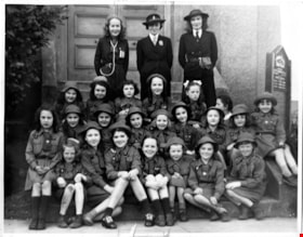
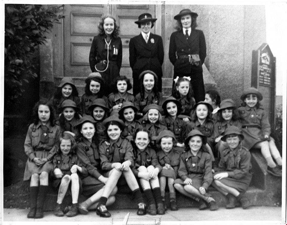
Presentation of 3 proficiency badges and 17 golden bars
https://search.heritageburnaby.ca/link/museumdescription4817
- Repository
- Burnaby Village Museum
- Date
- April 1948
- Collection/Fonds
- Burnaby Girl Guides fonds
- Description Level
- Item
- Physical Description
- 1 photograph : b&w ; 19.5 x 24.5 cm
- Scope and Content
- Photograph taken on April 7th, 1948 of the "Presentation of 3 Proficiency Badges and 17 Golden Bars". The item is a group photograph of twenty two Brownies and three Girl Guide leaders in uniforms in front of an unidentified church in Burnaby. The Girl Guide leaders are standing behind the girls an…
- Repository
- Burnaby Village Museum
- Collection/Fonds
- Burnaby Girl Guides fonds
- Description Level
- Item
- Physical Description
- 1 photograph : b&w ; 19.5 x 24.5 cm
- Scope and Content
- Photograph taken on April 7th, 1948 of the "Presentation of 3 Proficiency Badges and 17 Golden Bars". The item is a group photograph of twenty two Brownies and three Girl Guide leaders in uniforms in front of an unidentified church in Burnaby. The Girl Guide leaders are standing behind the girls and are identified from L to R as: Betty McPherson, Mrs. Coupland and Mrs. Hebron. The Brownies are seated on the steps in front of the Girl Guide leaders and are identified first row L to R: Dianne Smith, June Walker, __, __, Sheila McRae, Judy Beatty; second row L to R : Grace Martin, __,Lorna Steele, __, Norma Davidson, Joan Bates, ___,___; third row L to R : ___, Doreen Hayward, ___, ___, Ethel Smedley, Marilyn Cooper.
- Subjects
- Organizations - Girls' Societies and Clubs
- Ceremonies - Awards
- Buildings - Religious - Churches
- Names
- 5th Burnaby Brownie Pack
- Bate, May
- Girl Guides of Canada
- McPherson, Betty
- Hebron, Kathleen Billingham
- Bates, Joan
- McRae, Sheila
- Walker, June
- Beatty, Judy
- Steele, Lorna
- Davidson, Norma
- Smith, Dianne
- Martin, Grace
- Hayward, Doreen
- Smedley, Ethel
- Cooper, Marilyn
- Accession Code
- BV015.35.169
- Access Restriction
- No restrictions
- Reproduction Restriction
- No known restrictions
- Date
- April 1948
- Media Type
- Photograph
- Scan Resolution
- 600
- Scan Date
- October 22, 2020
- Scale
- 100
- Notes
- Transcribed title from page of scrapbook
- Photograph is a part of original scrapbook page from "5th Brownie Pack" 1948-1965 Item BV015.35.156
Images
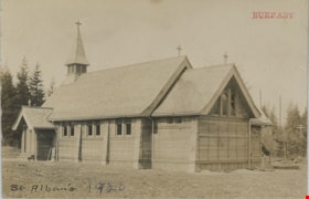
St. Alban's church
https://search.heritageburnaby.ca/link/museumdescription19780
- Repository
- Burnaby Village Museum
- Date
- 1920
- Collection/Fonds
- Esther Love Stanley fonds
- Description Level
- Item
- Physical Description
- 1 photograph : b&w postcard ; 8.5 x 13.5 cm
- Scope and Content
- Photograph of St. Albans the Martyr Anglican Church. This was probably the second Burnaby church (after St. John the Divine Anglican Church near Central Park), built c. 1909. Members of the Love family worshiped here and many got married in this church.
- Repository
- Burnaby Village Museum
- Collection/Fonds
- Esther Love Stanley fonds
- Description Level
- Item
- Physical Description
- 1 photograph : b&w postcard ; 8.5 x 13.5 cm
- Scope and Content
- Photograph of St. Albans the Martyr Anglican Church. This was probably the second Burnaby church (after St. John the Divine Anglican Church near Central Park), built c. 1909. Members of the Love family worshiped here and many got married in this church.
- Subjects
- Buildings - Religious - Churches
- Geographic Access
- 19th Avenue
- Street Address
- 7717 19th Avenue
- Accession Code
- BV022.32.202
- Access Restriction
- No restrictions
- Reproduction Restriction
- No known restrictions
- Date
- 1920
- Media Type
- Photograph
- Historic Neighbourhood
- Edmonds (Historic Neighbourhood)
- Planning Study Area
- Edmonds Area
- Scan Resolution
- 600
- Scan Date
- 2023-04-04
- Notes
- Title based on contents of photograph
- Photograph is part of Esther Love Stanley photograph album 1 (BV022.32.1)
Images

![St. Albans the Martyr, [ca.1910] thumbnail](/media/hpo/_Data/_BVM_Cartographic_Material/2003/2003_0083_0048_001.jpg?width=280)
St. Albans the Martyr
https://search.heritageburnaby.ca/link/museumdescription11926
- Repository
- Burnaby Village Museum
- Date
- [ca.1910]
- Collection/Fonds
- Ronald G. Scobbie collection
- Description Level
- Item
- Physical Description
- 1 plan : black ink and watercol. on paper ; 30.45 x 30.5 cm
- Scope and Content
- Item consists of building insurance plan of "St. Albans the Martyr / Lots 45 & 46 North Part DL 28 / GP1 N.W.D." Edmonds Street is to the north, Douglas Road to the west and 19th Avenue to the south.
- Repository
- Burnaby Village Museum
- Collection/Fonds
- Ronald G. Scobbie collection
- Description Level
- Item
- Physical Description
- 1 plan : black ink and watercol. on paper ; 30.45 x 30.5 cm
- Material Details
- Scale 1 inch = 40 feet
- Scope and Content
- Item consists of building insurance plan of "St. Albans the Martyr / Lots 45 & 46 North Part DL 28 / GP1 N.W.D." Edmonds Street is to the north, Douglas Road to the west and 19th Avenue to the south.
- Subjects
- Buildings - Religious - Churches
- Accession Code
- BV003.83.48
- Access Restriction
- No restrictions
- Reproduction Restriction
- No known restrictions
- Date
- [ca.1910]
- Media Type
- Cartographic Material
- Scan Resolution
- 600
- Scan Date
- 15-Jan-2021
- Scale
- 100
- Notes
- Transcribed title
- Note in pencil on verso reads: "St. Albans the Martyr / Lots 45 & 46 North Part DL 28 / 1" = 40' "
- Note in balck in on verso reads: "3704"
Images
![St. Albans the Martyr, [ca.1910] thumbnail](/media/hpo/_Data/_BVM_Cartographic_Material/2003/2003_0083_0048_001.jpg)
![St. Helen's Church, [ca.1910] thumbnail](/media/hpo/_Data/_BVM_Cartographic_Material/2003/2003_0083_0051_001.jpg?width=280)
St. Helen's Church
https://search.heritageburnaby.ca/link/museumdescription11929
- Repository
- Burnaby Village Museum
- Date
- [ca.1910]
- Collection/Fonds
- Ronald G. Scobbie collection
- Description Level
- Item
- Physical Description
- 1 plan : black ink and watercol. on paper ; 30.45 x 30.5 cm
- Scope and Content
- Item consists of building insurance plan of "St. Helen's Church / Lots 11 & 12 BK 7 DL 186 / GP1 N.W.D." . Ingleton Ave is identified to the east and Pandora St. to the south.
- Repository
- Burnaby Village Museum
- Collection/Fonds
- Ronald G. Scobbie collection
- Description Level
- Item
- Physical Description
- 1 plan : black ink and watercol. on paper ; 30.45 x 30.5 cm
- Material Details
- Scale 1 inch = 20 feet
- Scope and Content
- Item consists of building insurance plan of "St. Helen's Church / Lots 11 & 12 BK 7 DL 186 / GP1 N.W.D." . Ingleton Ave is identified to the east and Pandora St. to the south.
- Subjects
- Buildings - Religious - Churches
- Accession Code
- BV003.83.51
- Access Restriction
- No restrictions
- Reproduction Restriction
- No known restrictions
- Date
- [ca.1910]
- Media Type
- Cartographic Material
- Scan Resolution
- 600
- Scan Date
- 15-Jan-2021
- Scale
- 100
- Notes
- Transcribed title
- Note in pencil on verso reads: ""St. Helen's Church / Lots 11 & 12 BK 7 DL 186 / 1" = 20' "
- Note in balck in on verso reads: "3704"
Images
![St. Helen's Church, [ca.1910] thumbnail](/media/hpo/_Data/_BVM_Cartographic_Material/2003/2003_0083_0051_001.jpg)
![St. John the Divine, [ca.1910] thumbnail](/media/hpo/_Data/_BVM_Cartographic_Material/2003/2003_0083_0044_001.jpg?width=280)
St. John the Divine
https://search.heritageburnaby.ca/link/museumdescription11922
- Repository
- Burnaby Village Museum
- Date
- [ca.1910]
- Collection/Fonds
- Ronald G. Scobbie collection
- Description Level
- Item
- Physical Description
- 1 plan : black ink and watercol. on paper ; 30.45 x 30.5 cm
- Scope and Content
- Item consists of building insurance plan of "St. John the Divine / Lot "A" BK. 49 DL 35 GP1 N.W.D.". Kingsway is identified to the south of building.
- Repository
- Burnaby Village Museum
- Collection/Fonds
- Ronald G. Scobbie collection
- Description Level
- Item
- Physical Description
- 1 plan : black ink and watercol. on paper ; 30.45 x 30.5 cm
- Material Details
- Scale 1 inch = 20 feet
- Scope and Content
- Item consists of building insurance plan of "St. John the Divine / Lot "A" BK. 49 DL 35 GP1 N.W.D.". Kingsway is identified to the south of building.
- Subjects
- Buildings - Religious - Churches
- Accession Code
- BV003.83.44
- Access Restriction
- No restrictions
- Reproduction Restriction
- No known restrictions
- Date
- [ca.1910]
- Media Type
- Cartographic Material
- Scan Resolution
- 600
- Scan Date
- 15-Jan-2021
- Scale
- 100
- Notes
- Transcribed title
- Note in pencil on verso reads: "St. John the Divine / Lot "A" BK. 49 DL 35 / 1"=20' "
- Note in balck in on verso reads: "3704"
Images
![St. John the Divine, [ca.1910] thumbnail](/media/hpo/_Data/_BVM_Cartographic_Material/2003/2003_0083_0044_001.jpg)