Narrow Results By
Subject
- Animals - Dogs 1
- Buildings 1
- Buildings - Civic - City Halls 1
- Buildings - Civic - Museums 1
- Buildings - Commercial - Hotels and Motels 1
- Buildings - Commercial - Stores 1
- Buildings Components - Fireplaces 1
- Buildings - Industrial - Factories 1
- Buildings - Industrial - Powerhouses 1
- Buildings - Religious - Churches 3
- Buildings - Residential - Cabins 2
- Buildings - Residential - Houses 20
Person / Organization
- Aliceville Hotel 1
- Birchell, Daisy 1
- Burnaby City Hall 1
- Burnaby Historical Society 1
- Burnaby Village Museum 3
- Central Park Presbyterian Church 1
- Dale, Sarah Gillon 1
- Friends of Interurban 1223 1
- Gordon Presbyterian Church 2
- Hill, Charlotte Elizabeth Vidal 1
- Hill, Louis Claude "Claude" 1
- Hill, Minard Gerald "Gerry" 2

1982 - Moving the Roberts House
https://search.heritageburnaby.ca/link/archivedescription91894
- Repository
- City of Burnaby Archives
- Date
- 2015
- Collection/Fonds
- Small family fonds
- Description Level
- Item
- Physical Description
- 1 photograph : col. copy print ; 10 cm x 15 cm
- Scope and Content
- Photograph of the "Roberts House" in its new location at 5496 Dominion Street.
- Repository
- City of Burnaby Archives
- Date
- 2015
- Collection/Fonds
- Small family fonds
- Physical Description
- 1 photograph : col. copy print ; 10 cm x 15 cm
- Description Level
- Item
- Record No.
- 620-075
- Access Restriction
- No restrictions
- Reproduction Restriction
- No reproduction permitted
- Accession Number
- 2017-01
- Scope and Content
- Photograph of the "Roberts House" in its new location at 5496 Dominion Street.
- Subjects
- Buildings - Residential - Houses
- Media Type
- Photograph
- Notes
- Transcribed title
- Title transcribed from donor's notes
- Note in blue ink on verso of photograph reads: "P.17"
- Street Address
- 5496 Dominion Street
- Historic Neighbourhood
- Burnaby Lake (Historic Neighbourhood)
- Planning Study Area
- Ardingley-Sprott Area
Images


5495 Dominion Street and 5505 Dominion Street
https://search.heritageburnaby.ca/link/archivedescription91857
- Repository
- City of Burnaby Archives
- Date
- April 1, 2015
- Collection/Fonds
- Small family fonds
- Description Level
- Item
- Physical Description
- 1 photograph : col. ; 10 cm x 15 cm
- Scope and Content
- Photograph of a tan duplex located at 5495 Dominion Street (left) and clay-coloured house at 5505 Dominion Street (right). The photograph was taken from 5496 Dominion street, looking north.
- Repository
- City of Burnaby Archives
- Date
- April 1, 2015
- Collection/Fonds
- Small family fonds
- Physical Description
- 1 photograph : col. ; 10 cm x 15 cm
- Description Level
- Item
- Record No.
- 620-038
- Access Restriction
- No restrictions
- Reproduction Restriction
- No reproduction permitted
- Accession Number
- 2017-01
- Scope and Content
- Photograph of a tan duplex located at 5495 Dominion Street (left) and clay-coloured house at 5505 Dominion Street (right). The photograph was taken from 5496 Dominion street, looking north.
- Subjects
- Buildings - Residential - Houses
- Media Type
- Photograph
- Notes
- Transcribed title
- Title transcribed from donor's notes
- Note in blue ink on verso of photograph reads: "P.37"
- Note in blue ink on verso of photograph reads: "April 1 , 2015 / 5495 Dominion st. 5505 Dominion St."
- 5493 Dominion Street was previously numbered 3107 Dominion Street and it was later subdivided into two lots: 5491 and 5495 Dominion Street.
- Photograph 620-037 depicts the same houses prior to being repainted.
- Historic Neighbourhood
- Burnaby Lake (Historic Neighbourhood)
- Planning Study Area
- Ardingley-Sprott Area
Images

![Aliceville Hotel, [1892] thumbnail](/media/hpo/_Data/_Archives_Images/_Unrestricted/371/421-001.jpg?width=280)
Aliceville Hotel
https://search.heritageburnaby.ca/link/archivedescription38369
- Repository
- City of Burnaby Archives
- Date
- [1892]
- Collection/Fonds
- Burnaby Historical Society fonds
- Description Level
- Item
- Physical Description
- 1 photograph : b&w ; 10 x 12.5 cm
- Scope and Content
- Photograph of the Aliceville Hotel at Burrard Inlet which was built in 1892. On the back of the photograph, a map showing the hotel's location in relation to Hastings Street and North Road has been sketched in pencil.
- Repository
- City of Burnaby Archives
- Date
- [1892]
- Collection/Fonds
- Burnaby Historical Society fonds
- Subseries
- Photographs subseries
- Physical Description
- 1 photograph : b&w ; 10 x 12.5 cm
- Description Level
- Item
- Record No.
- 421-001
- Access Restriction
- No restrictions
- Reproduction Restriction
- No known restrictions
- Accession Number
- BHS2001-10
- Scope and Content
- Photograph of the Aliceville Hotel at Burrard Inlet which was built in 1892. On the back of the photograph, a map showing the hotel's location in relation to Hastings Street and North Road has been sketched in pencil.
- Names
- Aliceville Hotel
- Media Type
- Photograph
- Notes
- Title based on contents of photograph
- Geographic Access
- Hastings Street
- Barnet Road
- Street Address
- 9951 Barnet Road
- Planning Study Area
- Burnaby Mountain Area
Images
![Aliceville Hotel, [1892] thumbnail](/media/hpo/_Data/_Archives_Images/_Unrestricted/371/421-001.jpg)
Anniversary Sunday
https://search.heritageburnaby.ca/link/archivedescription78042
- Repository
- City of Burnaby Archives
- Date
- 2012
- Collection/Fonds
- Gordon Presbyterian Church fonds
- Description Level
- Item
- Physical Description
- 1 photograph : col ; 10 x 15 cm
- Scope and Content
- Photograph of "Anniversary Sunday" inside the Gordon Presbyterian Church, the celebration of the church's one hundredth anniversary.
- Repository
- City of Burnaby Archives
- Date
- 2012
- Collection/Fonds
- Gordon Presbyterian Church fonds
- Physical Description
- 1 photograph : col ; 10 x 15 cm
- Description Level
- Item
- Record No.
- 555-002
- Access Restriction
- In Archives only
- Reproduction Restriction
- Reproduce for fair dealing purposes only
- Accession Number
- 2013-12
- Scope and Content
- Photograph of "Anniversary Sunday" inside the Gordon Presbyterian Church, the celebration of the church's one hundredth anniversary.
- Subjects
- Buildings - Religious - Churches
- Media Type
- Photograph
- Notes
- Title based on accompanying photo identification key
- Geographic Access
- Edmonds Street
- Street Address
- 7457 Edmonds Street
- Historic Neighbourhood
- Edmonds (Historic Neighbourhood)
- Planning Study Area
- Richmond Park Area
![Brick Houses under Construction, [between 1899 and 1910] thumbnail](/media/hpo/_Data/_Archives_Images/_Unrestricted/513/514-002.jpg?width=280)
Brick Houses under Construction
https://search.heritageburnaby.ca/link/archivedescription64653
- Repository
- City of Burnaby Archives
- Date
- [between 1899 and 1910]
- Collection/Fonds
- Ernest Winch fonds
- Description Level
- Item
- Physical Description
- 1 photograph : b&w cabinet card ; 10 x 14.5 cm, mounted on card 10.5 x 16.5 cm
- Scope and Content
- Photograph of two brick houses under construction on High Street at Epping, Essex, England. These buildings were constructed by Ernest E. Winch.
- Repository
- City of Burnaby Archives
- Date
- [between 1899 and 1910]
- Collection/Fonds
- Ernest Winch fonds
- Physical Description
- 1 photograph : b&w cabinet card ; 10 x 14.5 cm, mounted on card 10.5 x 16.5 cm
- Description Level
- Item
- Record No.
- 514-002
- Access Restriction
- No restrictions
- Reproduction Restriction
- No known restrictions
- Accession Number
- 2010-06
- Scope and Content
- Photograph of two brick houses under construction on High Street at Epping, Essex, England. These buildings were constructed by Ernest E. Winch.
- Media Type
- Photograph
- Photographer
- Challoner-Courtenay, E.J.
- Notes
- Title based on contents of photograph
Images
![Brick Houses under Construction, [between 1899 and 1910] thumbnail](/media/hpo/_Data/_Archives_Images/_Unrestricted/513/514-002.jpg)
![Brick Houses under Construction, [between 1899 and 1910] thumbnail](/media/hpo/_Data/_Archives_Images/_Unrestricted/513/514-003.jpg?width=280)
Brick Houses under Construction
https://search.heritageburnaby.ca/link/archivedescription64654
- Repository
- City of Burnaby Archives
- Date
- [between 1899 and 1910]
- Collection/Fonds
- Ernest Winch fonds
- Description Level
- Item
- Physical Description
- 1 photograph : b&w cabinet card ; 10 x 14.5 cm, mounted on card 10.5 x 16.5 cm
- Scope and Content
- Photograph of two brick houses under construction on High Street at Epping, Essex, England. These buildings were constructed by Ernest E. Winch.
- Repository
- City of Burnaby Archives
- Date
- [between 1899 and 1910]
- Collection/Fonds
- Ernest Winch fonds
- Physical Description
- 1 photograph : b&w cabinet card ; 10 x 14.5 cm, mounted on card 10.5 x 16.5 cm
- Description Level
- Item
- Record No.
- 514-003
- Access Restriction
- No restrictions
- Reproduction Restriction
- No known restrictions
- Accession Number
- 2010-06
- Scope and Content
- Photograph of two brick houses under construction on High Street at Epping, Essex, England. These buildings were constructed by Ernest E. Winch.
- Subjects
- Construction
- Buildings - Residential - Houses
- Construction Tools and Equipment
- Occupations - Labourers
- Media Type
- Photograph
- Photographer
- Challoner-Courtenay, E.J.
- Notes
- Title based on contents of photograph
Images
![Brick Houses under Construction, [between 1899 and 1910] thumbnail](/media/hpo/_Data/_Archives_Images/_Unrestricted/513/514-003.jpg)
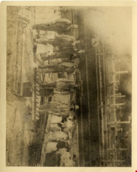
Brickyard
https://search.heritageburnaby.ca/link/archivedescription38403
- Repository
- City of Burnaby Archives
- Date
- 1898
- Collection/Fonds
- Burnaby Historical Society fonds
- Description Level
- Item
- Physical Description
- 1 photograph : sepia ; 10 x 12.5 cm
- Scope and Content
- Photograph of a group of fourteen people standing in a brickyard. This is believed to be one of the Brickyards co-owned by James Gilmore Ettinger (one was in Burnaby, the other in Surrey).
- Repository
- City of Burnaby Archives
- Date
- 1898
- Collection/Fonds
- Burnaby Historical Society fonds
- Subseries
- Ettinger family subseries
- Physical Description
- 1 photograph : sepia ; 10 x 12.5 cm
- Description Level
- Item
- Record No.
- 428-002
- Access Restriction
- No restrictions
- Reproduction Restriction
- No known restrictions
- Accession Number
- BHS2002-03
- Scope and Content
- Photograph of a group of fourteen people standing in a brickyard. This is believed to be one of the Brickyards co-owned by James Gilmore Ettinger (one was in Burnaby, the other in Surrey).
- Subjects
- Buildings - Industrial - Factories
- Media Type
- Photograph
- Notes
- Title based on contents of photograph
Images

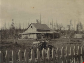
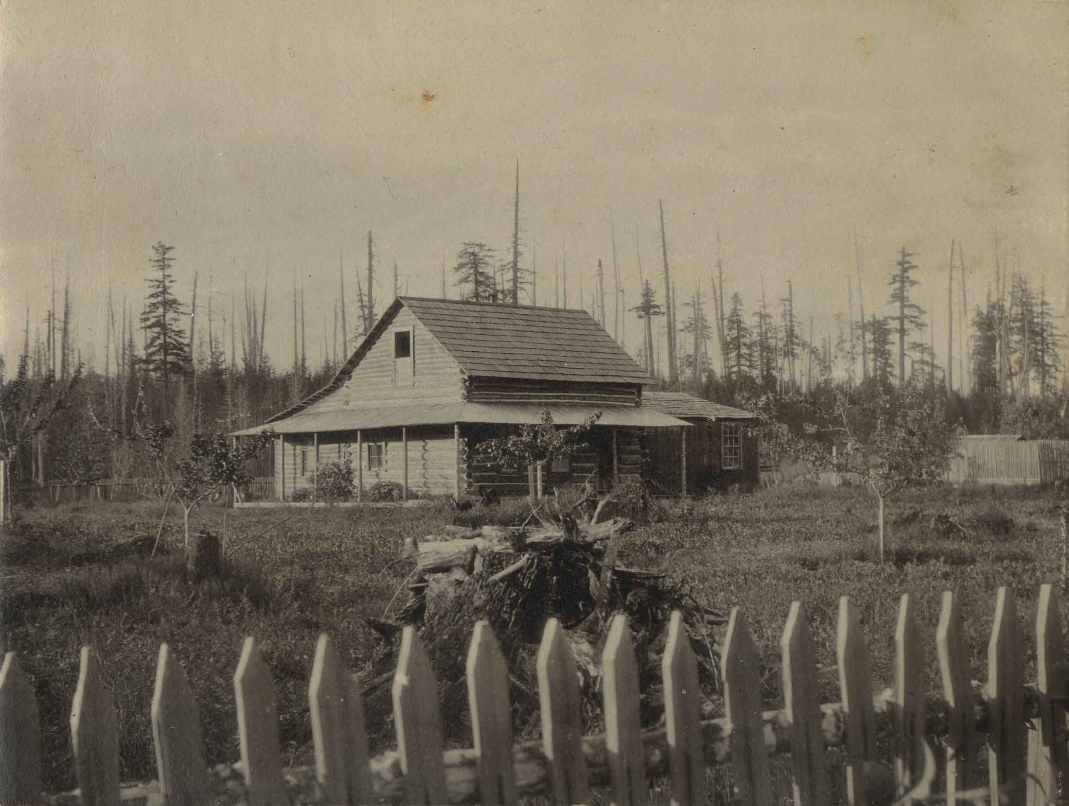
![Brookfield, [1896] thumbnail](/media/hpo/_Data/_Archives_Images/_Unrestricted/477/477-945.jpg?width=280)
Brookfield
https://search.heritageburnaby.ca/link/archivedescription66232
- Repository
- City of Burnaby Archives
- Date
- [1896]
- Collection/Fonds
- Peers Family and Hill Family fonds
- Description Level
- Item
- Physical Description
- 1 photograph : b&w ; 9.5 x 13 cm
- Scope and Content
- Photograph of the first home of Claude Hill in the Burnaby Lake district. It was known as Brookfield. This was the birthplace of Kitty Hill. The property is the current site of the Burnaby Village Museum.
- Repository
- City of Burnaby Archives
- Date
- [1896]
- Collection/Fonds
- Peers Family and Hill Family fonds
- Physical Description
- 1 photograph : b&w ; 9.5 x 13 cm
- Description Level
- Item
- Record No.
- 477-945
- Access Restriction
- No restrictions
- Reproduction Restriction
- No known restrictions
- Accession Number
- 2007-12
- Scope and Content
- Photograph of the first home of Claude Hill in the Burnaby Lake district. It was known as Brookfield. This was the birthplace of Kitty Hill. The property is the current site of the Burnaby Village Museum.
- Subjects
- Buildings - Residential - Houses
- Media Type
- Photograph
- Notes
- Title based on contents of photograph
- Note on verso reads "1902"
- Geographic Access
- Deer Lake Avenue
- Street Address
- 6501 Deer Lake Avenue
- Historic Neighbourhood
- Burnaby Lake (Historic Neighbourhood)
- Planning Study Area
- Morley-Buckingham Area
Images
![Brookfield, [1896] thumbnail](/media/hpo/_Data/_Archives_Images/_Unrestricted/477/477-945.jpg)

Brookfield
https://search.heritageburnaby.ca/link/archivedescription39520
- Repository
- City of Burnaby Archives
- Date
- 1896
- Collection/Fonds
- Peers Family and Hill Family fonds
- Description Level
- Item
- Physical Description
- 1 photograph : b&w ; 11.5 x 16.1 cm on page 21.5 x 28 cm (pasted in album)
- Scope and Content
- Photograph of the home of Claude Hill in the Burnaby Lake district. It was known as Brookfield. The property is the current site of the Burnaby Village Museum.
- Repository
- City of Burnaby Archives
- Date
- 1896
- Collection/Fonds
- Peers Family and Hill Family fonds
- Physical Description
- 1 photograph : b&w ; 11.5 x 16.1 cm on page 21.5 x 28 cm (pasted in album)
- Description Level
- Item
- Record No.
- 477-839
- Access Restriction
- No restrictions
- Reproduction Restriction
- No known restrictions
- Accession Number
- 2007-12
- Scope and Content
- Photograph of the home of Claude Hill in the Burnaby Lake district. It was known as Brookfield. The property is the current site of the Burnaby Village Museum.
- Subjects
- Buildings - Residential - Houses
- Media Type
- Photograph
- Notes
- Title based on contents of photograph
- Geographic Access
- Deer Lake Avenue
- Street Address
- 6501 Deer Lake Avenue
- Historic Neighbourhood
- Burnaby Lake (Historic Neighbourhood)
- Planning Study Area
- Morley-Buckingham Area
Images

![Burnaby's first Municipal Hall, [between 1899 and 1911] (date of original), copied 1995 thumbnail](/media/hpo/_Data/_Archives_Images/_Unrestricted/316/316-006.jpg?width=280)
Burnaby's first Municipal Hall
https://search.heritageburnaby.ca/link/archivedescription37100
- Repository
- City of Burnaby Archives
- Date
- [between 1899 and 1911] (date of original), copied 1995
- Collection/Fonds
- Burnaby Historical Society fonds
- Description Level
- Item
- Physical Description
- 1 photograph : b&w ; 10 x 15 cm print
- Scope and Content
- Photograph of council members and others sitting and standing on the steps of Burnaby's first Municipal Hall.
- Repository
- City of Burnaby Archives
- Date
- [between 1899 and 1911] (date of original), copied 1995
- Collection/Fonds
- Burnaby Historical Society fonds
- Subseries
- Byrne family subseries
- Physical Description
- 1 photograph : b&w ; 10 x 15 cm print
- Description Level
- Item
- Record No.
- 316-006
- Access Restriction
- No restrictions
- Reproduction Restriction
- No known restrictions
- Accession Number
- BHS1995-04
- Scope and Content
- Photograph of council members and others sitting and standing on the steps of Burnaby's first Municipal Hall.
- Names
- Burnaby City Hall
- Media Type
- Photograph
- Notes
- Title based on contents of photograph
- Geographic Access
- Kingsway
- Street Address
- 7252 Kingsway
- Historic Neighbourhood
- Edmonds (Historic Neighbourhood)
- Planning Study Area
- Stride Avenue Area
Images
![Burnaby's first Municipal Hall, [between 1899 and 1911] (date of original), copied 1995 thumbnail](/media/hpo/_Data/_Archives_Images/_Unrestricted/316/316-006.jpg)

Central Park Presbyterian Church
https://search.heritageburnaby.ca/link/archivedescription36673
- Repository
- City of Burnaby Archives
- Date
- 1896 (date of original), copied 1992
- Collection/Fonds
- Burnaby Historical Society fonds
- Description Level
- Item
- Physical Description
- 1 photograph : b&w ; 10.1 x 14.9 cm print
- Scope and Content
- Photograph of the exterior of Central Park Presbyterian Church. Typed note at the bottom of the photograph reads, "The Original Presbyterian Church on Westminster Road at Central Park as in approx. 1896. Burned down and rebuilt. Mrs. P. Oben."
- Repository
- City of Burnaby Archives
- Date
- 1896 (date of original), copied 1992
- Collection/Fonds
- Burnaby Historical Society fonds
- Subseries
- Burnaby Centennial Anthology subseries
- Physical Description
- 1 photograph : b&w ; 10.1 x 14.9 cm print
- Description Level
- Item
- Record No.
- 315-028
- Access Restriction
- No restrictions
- Reproduction Restriction
- No known restrictions
- Accession Number
- BHS1994-04
- Scope and Content
- Photograph of the exterior of Central Park Presbyterian Church. Typed note at the bottom of the photograph reads, "The Original Presbyterian Church on Westminster Road at Central Park as in approx. 1896. Burned down and rebuilt. Mrs. P. Oben."
- Subjects
- Buildings - Religious - Churches
- Media Type
- Photograph
- Notes
- Title based on contents of photograph
- Geographic Access
- Westminster Avenue
- Kingsway
- Street Address
- 3777 Kingsway
- Historic Neighbourhood
- Central Park (Historic Neighbourhood)
- Planning Study Area
- Garden Village Area
Images

![Dorothy and Charlotte Vidal, [between 1898 and 1890] thumbnail](/media/hpo/_Data/_Archives_Images/_Unrestricted/550/550-036.jpg?width=280)
Dorothy and Charlotte Vidal
https://search.heritageburnaby.ca/link/archivedescription82412
- Repository
- City of Burnaby Archives
- Date
- [between 1898 and 1890]
- Collection/Fonds
- Hill family and Vidal family fonds
- Description Level
- Item
- Physical Description
- 1 photograph : b&w ; 7.5 x 10.5 cm
- Scope and Content
- Photograph shows the back of two girls identified as Charlotte Elizabeth Vidal Hill and Dorothy Kate Vidal Loomis, standing against an unidentified man.
- Repository
- City of Burnaby Archives
- Date
- [between 1898 and 1890]
- Collection/Fonds
- Hill family and Vidal family fonds
- Physical Description
- 1 photograph : b&w ; 7.5 x 10.5 cm
- Description Level
- Item
- Record No.
- 550-036
- Access Restriction
- No restrictions
- Reproduction Restriction
- No known restrictions
- Accession Number
- 2013-03
- Scope and Content
- Photograph shows the back of two girls identified as Charlotte Elizabeth Vidal Hill and Dorothy Kate Vidal Loomis, standing against an unidentified man.
- Subjects
- Buildings
- Media Type
- Photograph
- Notes
- Title based on caption accompanying photograph and contents of photograph
- Note in pencil on album page photograph reads: "Charlotte and Dorothy Vidal"
- Note in blue pen on verso reads: "Mom / Aunt Dor"
Images
![Dorothy and Charlotte Vidal, [between 1898 and 1890] thumbnail](/media/hpo/_Data/_Archives_Images/_Unrestricted/550/550-036.jpg)

Edison Road Power House
https://search.heritageburnaby.ca/link/archivedescription36086
- Repository
- City of Burnaby Archives
- Date
- 1893 (date of original), copied November 26, 1975
- Collection/Fonds
- Burnaby Historical Society fonds
- Description Level
- Item
- Physical Description
- 1 photograph : b&w ; 10.5 x 14 cm print
- Scope and Content
- Photograph of the Edison Road Power House, of the Westminster and Vancouver Tramway Co. Ltd., the first electric interurban street railway in North America. This power house stood between Vancouver Road (Kingsway) and the line to Vancouver. (Edison Road is now Griffiths Avenue).
- Repository
- City of Burnaby Archives
- Date
- 1893 (date of original), copied November 26, 1975
- Collection/Fonds
- Burnaby Historical Society fonds
- Subseries
- Columbian Newspaper subseries
- Physical Description
- 1 photograph : b&w ; 10.5 x 14 cm print
- Description Level
- Item
- Record No.
- 222-009
- Access Restriction
- No restrictions
- Reproduction Restriction
- No known restrictions
- Accession Number
- BHS1989-19
- Scope and Content
- Photograph of the Edison Road Power House, of the Westminster and Vancouver Tramway Co. Ltd., the first electric interurban street railway in North America. This power house stood between Vancouver Road (Kingsway) and the line to Vancouver. (Edison Road is now Griffiths Avenue).
- Media Type
- Photograph
- Notes
- Title based on contents of photograph
- Geographic Access
- Griffiths Avenue
- Kingsway
- Historic Neighbourhood
- Edmonds (Historic Neighbourhood)
- Planning Study Area
- Kingsway-Beresford Area
Images

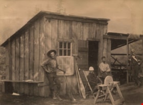
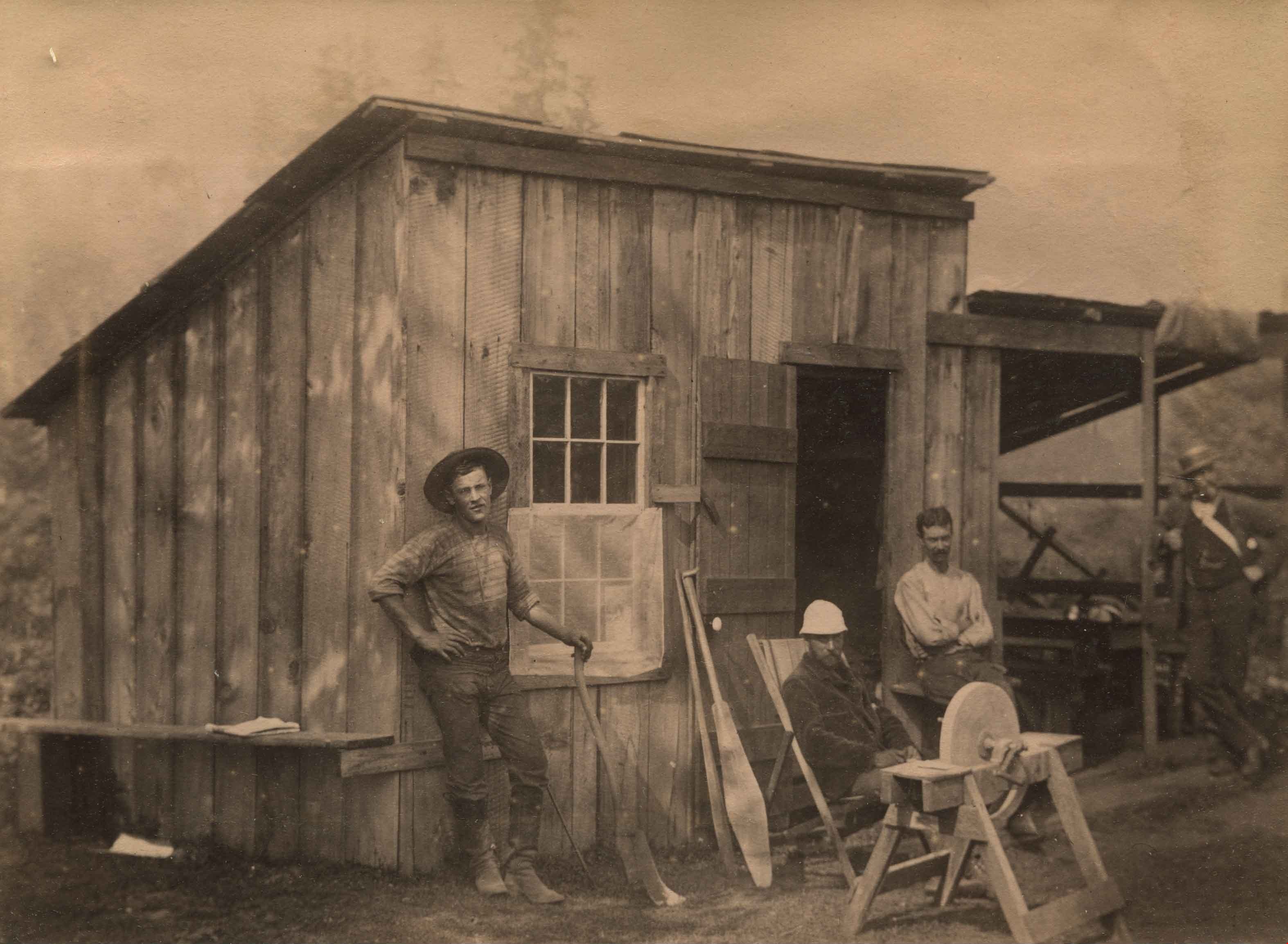
Four men in front of a cabin
https://search.heritageburnaby.ca/link/archivedescription39513
- Repository
- City of Burnaby Archives
- Date
- 1890
- Collection/Fonds
- Peers Family and Hill Family fonds
- Description Level
- Item
- Physical Description
- 1 photograph : b&w ; 9.8 x 13.5 cm on page 21.5 x 28 cm (pasted in album)
- Scope and Content
- Photograph of four men in front of a cabin. The man sitting behind the grindstone is Claude Hill. This cabin was most likely Claude Hill's residence in Murrayville (Langley) near the United States border where he lived during the late 1880s and early 1890s. Another later Burnaby resident, Charles …
- Repository
- City of Burnaby Archives
- Date
- 1890
- Collection/Fonds
- Peers Family and Hill Family fonds
- Physical Description
- 1 photograph : b&w ; 9.8 x 13.5 cm on page 21.5 x 28 cm (pasted in album)
- Description Level
- Item
- Record No.
- 477-832
- Access Restriction
- No restrictions
- Reproduction Restriction
- No known restrictions
- Accession Number
- 2007-12
- Scope and Content
- Photograph of four men in front of a cabin. The man sitting behind the grindstone is Claude Hill. This cabin was most likely Claude Hill's residence in Murrayville (Langley) near the United States border where he lived during the late 1880s and early 1890s. Another later Burnaby resident, Charles Sprott also lived in that area but both men eventually relocated to Burnaby.
- Subjects
- Buildings - Residential - Cabins
- Media Type
- Photograph
- Notes
- Title based on caption accompanying photograph
Images
Kirby Cottage
https://search.heritageburnaby.ca/link/archivedescription39579
- Repository
- City of Burnaby Archives
- Date
- 1892
- Collection/Fonds
- Peers Family and Hill Family fonds
- Description Level
- Item
- Physical Description
- 1 photograph : b&w ; 7.2 x 9.4 cm on page 21.5 x 28 cm (pasted in album)
- Scope and Content
- Photograph of a cottage identified as the Kirby cottage in Whonnock, BC. A fence is seen in the foreground and cleared land can be seen in the background.
- Repository
- City of Burnaby Archives
- Date
- 1892
- Collection/Fonds
- Peers Family and Hill Family fonds
- Physical Description
- 1 photograph : b&w ; 7.2 x 9.4 cm on page 21.5 x 28 cm (pasted in album)
- Description Level
- Item
- Record No.
- 477-898
- Access Restriction
- No restrictions
- Reproduction Restriction
- No known restrictions
- Accession Number
- 2007-12
- Scope and Content
- Photograph of a cottage identified as the Kirby cottage in Whonnock, BC. A fence is seen in the foreground and cleared land can be seen in the background.
- Subjects
- Buildings - Residential - Cabins
- Media Type
- Photograph
- Notes
- Title based on caption accompanying photograph
Images

Looking east along Dominion street to corner of Douglas Road and Dominion Street
https://search.heritageburnaby.ca/link/archivedescription91876
- Repository
- City of Burnaby Archives
- Date
- 2016
- Collection/Fonds
- Small family fonds
- Description Level
- Item
- Physical Description
- 1 photograph : col. ; 10 cm x 15 cm
- Scope and Content
- Photograph of Dominion Street, looking east. The houses are largely obscured by tall hedges and bushes. The photograph was taken from the north side of the street, opposite 5496 Dominion Street.
- Repository
- City of Burnaby Archives
- Date
- 2016
- Collection/Fonds
- Small family fonds
- Physical Description
- 1 photograph : col. ; 10 cm x 15 cm
- Description Level
- Item
- Record No.
- 620-057
- Access Restriction
- No restrictions
- Reproduction Restriction
- No reproduction permitted
- Accession Number
- 2017-01
- Scope and Content
- Photograph of Dominion Street, looking east. The houses are largely obscured by tall hedges and bushes. The photograph was taken from the north side of the street, opposite 5496 Dominion Street.
- Media Type
- Photograph
- Notes
- Transcribed title
- Title transcribed from donor's notes
- Note in blue ink on verso of photograph reads: "P.19"
- Note in blue ink on verso of photograph reads: "2016 / Looking East along Dominion St to corner of Douglas Rd. and Dominion St."
- Photograph 620-056 taken from the same vantage point
- Geographic Access
- Dominion Street
- Street Address
- 5538 Dominion Street
- Historic Neighbourhood
- Burnaby Lake (Historic Neighbourhood)
- Planning Study Area
- Ardingley-Sprott Area
Images


Looking east from 3131 Douglas Road
https://search.heritageburnaby.ca/link/archivedescription91826
- Repository
- City of Burnaby Archives
- Date
- January 2016
- Collection/Fonds
- Small family fonds
- Description Level
- Item
- Physical Description
- 1 photograph : col. copy print ; 15 cm x 10 cm
- Scope and Content
- Photograph of the Roberts' front yard . A large oak tree stands in the centre of the photograph with a row of short shrubs on each side. The house located at 3090 Douglas Road is visible in the distance. The photograph is taken from 3131 Douglas Road, looking east.
- Repository
- City of Burnaby Archives
- Date
- January 2016
- Collection/Fonds
- Small family fonds
- Physical Description
- 1 photograph : col. copy print ; 15 cm x 10 cm
- Description Level
- Item
- Record No.
- 620-007
- Access Restriction
- No restrictions
- Reproduction Restriction
- No reproduction permitted
- Accession Number
- 2017-01
- Scope and Content
- Photograph of the Roberts' front yard . A large oak tree stands in the centre of the photograph with a row of short shrubs on each side. The house located at 3090 Douglas Road is visible in the distance. The photograph is taken from 3131 Douglas Road, looking east.
- Media Type
- Photograph
- Notes
- Transcribed title
- Title transcribed from donor's notes
- 5118 Douglas Road renumbered to 3131 Douglas Road in 1958 and to 5538 Dominion Street in 1970 or 1971
- Note in blue ink on verso of photograph reads: "Jan. 2016 / Looking East from Roberts' front yard"
- Note in blue ink on verso of photograph reads: "P8"
- Photograph 620-003 depicts the same house on 3090 Douglas Road.
- Street Address
- 3131 Douglas Road
- 5118 Douglas Road
- 5538 Dominion Street
- 3090 Douglas Road
- Historic Neighbourhood
- Burnaby Lake (Historic Neighbourhood)
- Planning Study Area
- Ardingley-Sprott Area
Images


Looking east from north side of 5118 Douglas Road - The Roberts House
https://search.heritageburnaby.ca/link/archivedescription91821
- Repository
- City of Burnaby Archives
- Date
- 2016
- Collection/Fonds
- Small family fonds
- Description Level
- Item
- Physical Description
- 1 photograph : col. ; 10 cm x 15 cm
- Scope and Content
- Photograph of a two-storey house located at 3090 Douglas Road. The house was constructed in 1922 and is painted white with brown trim. The photograph was taken from the Roberts' property at 5538 Dominion Street.
- Repository
- City of Burnaby Archives
- Date
- 2016
- Collection/Fonds
- Small family fonds
- Physical Description
- 1 photograph : col. ; 10 cm x 15 cm
- Description Level
- Item
- Record No.
- 620-002
- Access Restriction
- No restrictions
- Reproduction Restriction
- No reproduction permitted
- Accession Number
- 2017-01
- Scope and Content
- Photograph of a two-storey house located at 3090 Douglas Road. The house was constructed in 1922 and is painted white with brown trim. The photograph was taken from the Roberts' property at 5538 Dominion Street.
- Subjects
- Buildings - Residential - Houses
- Media Type
- Photograph
- Notes
- Transcribed title
- Title transcribed from donor's notes
- The same house is visible in the background of photograph 620-001
- Note in blue ink on verso of photograph reads: "Jan. 2016 / 3090 Douglas Rd. (N.E. Corner Douglas Road and Dominion St.)
- Note in blue ink on verson of photograph reads: "P3"
- 5538 Dominion Street was previously numbered previously 5118 Douglas Road and 3131 Douglas Road
- Street Address
- 3090 Douglas Road
- Historic Neighbourhood
- Burnaby Lake (Historic Neighbourhood)
- Planning Study Area
- Ardingley-Sprott Area
Images


Looking northwest along Dominion Street from near Douglas Road
https://search.heritageburnaby.ca/link/archivedescription91846
- Repository
- City of Burnaby Archives
- Date
- April 2015
- Collection/Fonds
- Small family fonds
- Description Level
- Item
- Physical Description
- 1 photograph : col. copy print ; 10 cm x 15 cm
- Scope and Content
- Photograph of Dominion Street, looking northwest from near Douglas Road. The house at 3093 Douglas Road is just visible between the trees. In 2009 Dominion Street was repaved and sidewalks were installed following a local improvement request to the City.
- Repository
- City of Burnaby Archives
- Date
- April 2015
- Collection/Fonds
- Small family fonds
- Physical Description
- 1 photograph : col. copy print ; 10 cm x 15 cm
- Description Level
- Item
- Record No.
- 620-027
- Access Restriction
- No restrictions
- Reproduction Restriction
- No reproduction permitted
- Accession Number
- 2017-01
- Scope and Content
- Photograph of Dominion Street, looking northwest from near Douglas Road. The house at 3093 Douglas Road is just visible between the trees. In 2009 Dominion Street was repaved and sidewalks were installed following a local improvement request to the City.
- Subjects
- Buildings - Residential - Houses
- Media Type
- Photograph
- Notes
- Transcribed title
- Note in blue ink on verso of photograph reads: "P.27"
- Note in blue ink on verso of photograph reads: "April 2015 / Looking Northwest along Dominion St. from near Douglas Rd."
- Street Address
- 3093 Douglas Road
- Historic Neighbourhood
- Burnaby Lake (Historic Neighbourhood)
- Planning Study Area
- Ardingley-Sprott Area
Images


Looking northwest from Douglas Road
https://search.heritageburnaby.ca/link/archivedescription91835
- Repository
- City of Burnaby Archives
- Date
- October 2015
- Collection/Fonds
- Small family fonds
- Description Level
- Item
- Physical Description
- 1 photograph : col. copy print ; 10 cm x 15 cm
- Scope and Content
- Photograph of a two-storey house located at 3131 Douglas Road. The house is white with brown trim and a brown shingle roof. The large oak tree in the front yard of the property is full of vibrant autum-coloured leaves. The photograph was taken from across Douglas Road, looking northwest.
- Repository
- City of Burnaby Archives
- Date
- October 2015
- Collection/Fonds
- Small family fonds
- Physical Description
- 1 photograph : col. copy print ; 10 cm x 15 cm
- Description Level
- Item
- Record No.
- 620-016
- Access Restriction
- No restrictions
- Reproduction Restriction
- No reproduction permitted
- Accession Number
- 2017-01
- Scope and Content
- Photograph of a two-storey house located at 3131 Douglas Road. The house is white with brown trim and a brown shingle roof. The large oak tree in the front yard of the property is full of vibrant autum-coloured leaves. The photograph was taken from across Douglas Road, looking northwest.
- Media Type
- Photograph
- Notes
- Transcribed title
- Title transcribed from donor's notes
- Note in blue ink on verso of photograph reads: "Oct. 2016 / 3131 Douglas Rd. - with Oak Tree - Fall Colours"
- Note in blue ink on verso of photograph reads: "P.16"
- 5118 Douglas Road renumbered to 3131 Douglas Road in 1958 and to 5538 Dominion Street in 1970 or 1971
- The oak tree (centre) is the same tree as in photographs 620-007, 620-014, and 620-015
- Street Address
- 3131 Douglas Road
- 5118 Douglas Road
- 5538 Dominion Street
- Historic Neighbourhood
- Burnaby Lake (Historic Neighbourhood)
- Planning Study Area
- Ardingley-Sprott Area
Images
