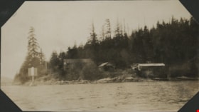
Buildings on shore of Burrard Inlet
https://search.heritageburnaby.ca/link/museumdescription20682
- Repository
- Burnaby Village Museum
- Date
- 1926
- Collection/Fonds
- David Geoffrey Llewellyn collection
- Description Level
- Item
- Physical Description
- 1 photograph : b&w ; 6 x 10.5 cm
- Scope and Content
- Photograph of buildings along the shore of Burrard Inlet. Photograph was taken during a Boy Scout visit to Carraholly, Port Moody on Easter weekend in 1926.
- Repository
- Burnaby Village Museum
- Collection/Fonds
- David Geoffrey Llewellyn collection
- Description Level
- Item
- Physical Description
- 1 photograph : b&w ; 6 x 10.5 cm
- Scope and Content
- Photograph of buildings along the shore of Burrard Inlet. Photograph was taken during a Boy Scout visit to Carraholly, Port Moody on Easter weekend in 1926.
- Names
- Boy Scouts of Canada
- Accession Code
- BV995.8.113
- Access Restriction
- No restrictions
- Reproduction Restriction
- No known restrictions
- Date
- 1926
- Media Type
- Photograph
- Scan Resolution
- 600
- Notes
- Title based on contents of photograph
- Photograph is part of photograph album BV995.8.1, pasted to page 35
- Annotation in white ink on album page reads: "CARAHOLLY / EASTER / 1926"
Images
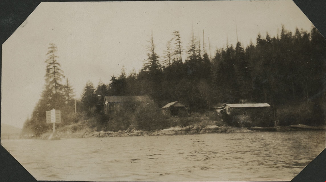
Industrial buildings on shore of Burrard Inlet
https://search.heritageburnaby.ca/link/museumdescription20685
- Repository
- Burnaby Village Museum
- Date
- 1926
- Collection/Fonds
- David Geoffrey Llewellyn collection
- Description Level
- Item
- Physical Description
- 1 photograph : b&w ; 5 x 7.5 cm
- Scope and Content
- Photograph of abandoned industrial buildings along the shore of Burrard Inlet.
- Repository
- Burnaby Village Museum
- Collection/Fonds
- David Geoffrey Llewellyn collection
- Description Level
- Item
- Physical Description
- 1 photograph : b&w ; 5 x 7.5 cm
- Scope and Content
- Photograph of abandoned industrial buildings along the shore of Burrard Inlet.
- Names
- Boy Scouts of Canada
- Accession Code
- BV995.8.116
- Access Restriction
- No restrictions
- Reproduction Restriction
- No known restrictions
- Date
- 1926
- Media Type
- Photograph
- Scan Resolution
- 600
- Notes
- Title based on contents of photograph
- Photograph is part of photograph album BV995.8.1, pasted to page 36
- Annotation in white ink on previous album page reads: "CARAHOLLY / EASTER / 1926"
Images

![Waterway and shoreline with buildings, [c. 1910] thumbnail](/media/hpo/_Data/_BVM_Images/2022/2022_0032_0026_001.jpg?width=280)
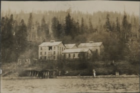
Waterway and shoreline with buildings
https://search.heritageburnaby.ca/link/museumdescription19309
- Repository
- Burnaby Village Museum
- Date
- [c. 1910]
- Collection/Fonds
- Esther Love Stanley fonds
- Description Level
- Item
- Physical Description
- 1 photograph : b&w ; 10.5 x 7.5 cm
- Scope and Content
- Photograph of a waterway with shoreline and buildings on the shore in the distance.
- Repository
- Burnaby Village Museum
- Collection/Fonds
- Esther Love Stanley fonds
- Description Level
- Item
- Physical Description
- 1 photograph : b&w ; 10.5 x 7.5 cm
- Material Details
- Photograph is over exposed, washing out some of the detail
- Scope and Content
- Photograph of a waterway with shoreline and buildings on the shore in the distance.
- Subjects
- Transportation - Boats
- Accession Code
- BV022.32.26
- Access Restriction
- No restrictions
- Reproduction Restriction
- No known restrictions
- Date
- [c. 1910]
- Media Type
- Photograph
- Scan Resolution
- 600
- Scan Date
- 2023-04-04
- Notes
- Title based on contents of photograph
- Photograph is part of Esther Love Stanley photograph album 1 (BV022.32.1)
Images
![Waterway and shoreline with buildings, [c. 1910] thumbnail](/media/hpo/_Data/_BVM_Images/2022/2022_0032_0026_001.jpg)

7530 Buller Avenue
https://search.heritageburnaby.ca/link/archivedescription98686
- Repository
- City of Burnaby Archives
- Date
- 2022
- Collection/Fonds
- Disappearing Burnaby collection
- Description Level
- Item
- Physical Description
- 1 photograph (jpeg) : col.
- Scope and Content
- Photograph of the exterior of a two-storey house located at 7530 Buller Avenue. The photograph depicts the house at dusk; the house stands behind a wooden fence and is surrounded by trees. The house was constructed in 1924 and was formerly known as "Ryverbrae," the William & Esther Burdick Residenc…
- Repository
- City of Burnaby Archives
- Date
- 2022
- Collection/Fonds
- Disappearing Burnaby collection
- Physical Description
- 1 photograph (jpeg) : col.
- Description Level
- Item
- Record No.
- 634-033
- Access Restriction
- No restrictions
- Reproduction Restriction
- No restrictions
- Accession Number
- 2022-14
- Scope and Content
- Photograph of the exterior of a two-storey house located at 7530 Buller Avenue. The photograph depicts the house at dusk; the house stands behind a wooden fence and is surrounded by trees. The house was constructed in 1924 and was formerly known as "Ryverbrae," the William & Esther Burdick Residence.
- Media Type
- Photograph
- Photographer
- Cheung, Nakita
- Notes
- Title taken from the associated blog post
- Associated blog post: https://disappearingburnaby.wordpress.com/2022/06/30/william-esther-burdick-residence/
- Geographic Access
- Buller Avenue
- Street Address
- 7530 Buller Avenue
- Historic Neighbourhood
- Alta Vista (Historic Neighbourhood)
- Planning Study Area
- Clinton-Glenwood Area
Images


Brookes family home, "Normanna"
https://search.heritageburnaby.ca/link/archivedescription35246
- Repository
- City of Burnaby Archives
- Date
- 1927
- Collection/Fonds
- Burnaby Historical Society fonds
- Description Level
- Item
- Physical Description
- 1 photograph : b&w ; 12.7 x 17.8 cm print
- Scope and Content
- Photograph of "Normanna," the Brookes family residence. This new Brookes family home was built in 1927 on the same site as the original house at 441 12th Avenue (later renumbered 7979 12th Avenue). Eventually, this became Normanna Norwegian rest home. The original house was built by Burnaby's firs…
- Repository
- City of Burnaby Archives
- Date
- 1927
- Collection/Fonds
- Burnaby Historical Society fonds
- Subseries
- Pioneer Tales subseries
- Physical Description
- 1 photograph : b&w ; 12.7 x 17.8 cm print
- Description Level
- Item
- Record No.
- 204-103
- Access Restriction
- No restrictions
- Reproduction Restriction
- No known restrictions
- Accession Number
- BHS1988-03
- Scope and Content
- Photograph of "Normanna," the Brookes family residence. This new Brookes family home was built in 1927 on the same site as the original house at 441 12th Avenue (later renumbered 7979 12th Avenue). Eventually, this became Normanna Norwegian rest home. The original house was built by Burnaby's first Reeve, Charles Shaw, and is now a designated heritage site at 7725 4th Street.
- Subjects
- Geographic Features - Gardens
- Buildings - Residential - Houses
- Buildings - Residential - Seniors Housing
- Buildings - Heritage
- Names
- Normanna Rest Home
- Media Type
- Photograph
- Notes
- Title based on contents of photograph
- Geographic Access
- 4th Street
- Street Address
- 7725 4th Street
- Historic Neighbourhood
- East Burnaby (Historic Neighbourhood)
- Planning Study Area
- Second Street Area
Images


Deer Lake
https://search.heritageburnaby.ca/link/archivedescription34297
- Repository
- City of Burnaby Archives
- Date
- 1923
- Collection/Fonds
- Burnaby Historical Society fonds
- Description Level
- Item
- Physical Description
- 1 photograph : sepia
- Scope and Content
- Photograph looking over Deer Lake and snow-covered ground towards buildings and houses. To the left is the cottage and house belonging to the Woodward sisters, Harriet and Maude. The cottage, and later the house, were also used as the Burnaby Lake Post Office and a school run by Harriet Woodward. …
- Repository
- City of Burnaby Archives
- Date
- 1923
- Collection/Fonds
- Burnaby Historical Society fonds
- Subseries
- Peers family subseries
- Physical Description
- 1 photograph : sepia
- Description Level
- Item
- Record No.
- 020-004
- Access Restriction
- No restrictions
- Reproduction Restriction
- No known restrictions
- Accession Number
- BHS2007-04
- Scope and Content
- Photograph looking over Deer Lake and snow-covered ground towards buildings and houses. To the left is the cottage and house belonging to the Woodward sisters, Harriet and Maude. The cottage, and later the house, were also used as the Burnaby Lake Post Office and a school run by Harriet Woodward. At the time of this photograph, it was in use as the Burnaby Lake United Church. In the middle of the picture, numerous boathouses and a diving tower can be seen at the shoreline of the lake. To the right of the copse of trees, on the hill, is the house and post office belonging to the Woodward sisters and right of that is the home built for William J. Walker in 1907 but owned by D.R. Boucher during the 1920s. To the far right the Pole Line Road (later, Sperling Avenue) is visible along with the home of Francis J. Peers, known as Greyfriars.
- Subjects
- Buildings - Heritage
- Buildings - Residential - Houses
- Geographic Features - Lakes and Ponds
- Buildings - Religious - Churches
- Media Type
- Photograph
- Notes
- Title based on caption accompanying photograph
- Geographic Access
- Sperling Avenue
- Deer Lake
- Rugby Street
- Historic Neighbourhood
- Burnaby Lake (Historic Neighbourhood)
- Planning Study Area
- Morley-Buckingham Area
Images


Oh! Zhhu Sam
https://search.heritageburnaby.ca/link/archivedescription98681
- Repository
- City of Burnaby Archives
- Date
- 2022
- Collection/Fonds
- Disappearing Burnaby collection
- Description Level
- Item
- Physical Description
- 1 photograph (jpeg) : col.
- Scope and Content
- Photograph of the 7500 block of Edmonds Street at dusk. The photograph is taken from across Edmonds Street and depicts two commercial buildings: Oh! Zzhu Sam Korean Restaurant and the European Butcher Boy Delicatessen & Grocery. Oh! Zzhu Sam, located at 7506 Edmonds Street, was constructed in 1976.…
- Repository
- City of Burnaby Archives
- Date
- 2022
- Collection/Fonds
- Disappearing Burnaby collection
- Physical Description
- 1 photograph (jpeg) : col.
- Description Level
- Item
- Record No.
- 634-028
- Access Restriction
- No restrictions
- Reproduction Restriction
- No restrictions
- Accession Number
- 2022-14
- Scope and Content
- Photograph of the 7500 block of Edmonds Street at dusk. The photograph is taken from across Edmonds Street and depicts two commercial buildings: Oh! Zzhu Sam Korean Restaurant and the European Butcher Boy Delicatessen & Grocery. Oh! Zzhu Sam, located at 7506 Edmonds Street, was constructed in 1976. Residential houses border the restaurant and grocery store, and a bus shelter, municipal garbage can, and the restaurant's illuminated neon sign stand in front of the buildings.
- Subjects
- Buildings - Commercial
- Buildings - Commercial - Grocery Stores
- Buildings - Commercial - Restaurants
- Media Type
- Photograph
- Photographer
- Cheung, Nakita
- Notes
- Title taken from the associated blog post
- Associated blog post: https://disappearingburnaby.wordpress.com/2022/07/29/oh-zzhu-sam/
- Geographic Access
- Edmonds Street
- Street Address
- 7506 Edmonds Street
- Historic Neighbourhood
- Edmonds (Historic Neighbourhood)
- Planning Study Area
- Edmonds Area
Images


Trafalgar Market
https://search.heritageburnaby.ca/link/archivedescription98665
- Repository
- City of Burnaby Archives
- Date
- 2022
- Collection/Fonds
- Disappearing Burnaby collection
- Description Level
- Item
- Physical Description
- 1 photograph (jpeg) : col.
- Scope and Content
- Photograph of the intersection of Imperial Street and Sussex Avenue at night and in the rain. The photograph shows the Trafalgar Market grocery store (located at 4398 Imperial Street; the building was constructed in 1940) on the corner, with a large display of flowers for sale under the awning in f…
- Repository
- City of Burnaby Archives
- Date
- 2022
- Collection/Fonds
- Disappearing Burnaby collection
- Physical Description
- 1 photograph (jpeg) : col.
- Description Level
- Item
- Record No.
- 634-012
- Access Restriction
- No restrictions
- Reproduction Restriction
- No restrictions
- Accession Number
- 2022-14
- Scope and Content
- Photograph of the intersection of Imperial Street and Sussex Avenue at night and in the rain. The photograph shows the Trafalgar Market grocery store (located at 4398 Imperial Street; the building was constructed in 1940) on the corner, with a large display of flowers for sale under the awning in front of the store. The street and traffic lights are reflected in the puddles on the road, and cars and other businesses are visible along Imperial Street.
- Subjects
- Buildings - Commercial
- Buildings - Commercial - Grocery Stores
- Buildings - Commercial - Stores
- Geographic Features - Roads
- Media Type
- Photograph
- Photographer
- Cheung, Nakita
- Notes
- Title taken from the associated blog post
- Associated blog post: https://disappearingburnaby.wordpress.com/2022/02/20/imperial-manor-2/
- Geographic Access
- Imperial Street
- Sussex Avenue
- Street Address
- 4398 Imperial Street
- Historic Neighbourhood
- Central Park (Historic Neighbourhood)
- Planning Study Area
- Sussex-Nelson Area
Images

![Alice and William Goodridge in front of store, [between 1925 and 1935] thumbnail](/media/hpo/_Data/_BVM_Images/2023/2023_0015_0001_001.jpg?width=280)
Alice and William Goodridge in front of store
https://search.heritageburnaby.ca/link/museumdescription20274
- Repository
- Burnaby Village Museum
- Date
- [between 1925 and 1935]
- Collection/Fonds
- Burnaby Village Museum Photograph collection
- Description Level
- Item
- Physical Description
- 1 photograph : b&w negative ; 12.5 x 10 cm
- Scope and Content
- Photograph of Alice Victoria (Goodridge) Norman and her brother William "Bill" Goodridge seated on the stoop outside the Goodridge grocery store located at 4835 Hastings Street in Burnaby. Signage on the windows and on the front of the store identify some of the trademarks of products sold in the s…
- Repository
- Burnaby Village Museum
- Collection/Fonds
- Burnaby Village Museum Photograph collection
- Description Level
- Item
- Physical Description
- 1 photograph : b&w negative ; 12.5 x 10 cm
- Scope and Content
- Photograph of Alice Victoria (Goodridge) Norman and her brother William "Bill" Goodridge seated on the stoop outside the Goodridge grocery store located at 4835 Hastings Street in Burnaby. Signage on the windows and on the front of the store identify some of the trademarks of products sold in the store including "Royal Crown Soap", "Cowan's" and "Winchester cigarettes". Two post office boxes are visible to the right of the couple.
- Subjects
- Buildings - Commercial
- Buildings - Commercial - Grocery Stores
- Buildings - Public - Post Offices
- Accession Code
- BV023.15.1
- Access Restriction
- No restrictions
- Reproduction Restriction
- No known restrictions
- Date
- [between 1925 and 1935]
- Media Type
- Photograph
- Scan Resolution
- 3200
- Scan Date
- 2023-09-21
- Notes
- Title based on contents of photograph
- 1 b&w contact sheet accompanying
Images
![Alice and William Goodridge in front of store, [between 1925 and 1935] thumbnail](/media/hpo/_Data/_BVM_Images/2023/2023_0015_0001_001.jpg)
![John Charles Goodridge holding grandchild, [between 1925 and 1935] thumbnail](/media/hpo/_Data/_BVM_Images/2023/2023_0015_0004_001.jpg?width=280)
John Charles Goodridge holding grandchild
https://search.heritageburnaby.ca/link/museumdescription20278
- Repository
- Burnaby Village Museum
- Date
- [between 1925 and 1935]
- Collection/Fonds
- Burnaby Village Museum Photograph collection
- Description Level
- Item
- Physical Description
- 1 photograph : b&w negative ; 12.5 x 10 cm
- Scope and Content
- Photograph of John Charles Bertram Goodridge holding his grandchild outside the Goodridge grocery store on Hastings Street in Burnaby. Canada Post mail boxes are visible behind them. One of the mail boxes is mounted on the door of the building and the other is free standing.
- Repository
- Burnaby Village Museum
- Collection/Fonds
- Burnaby Village Museum Photograph collection
- Description Level
- Item
- Physical Description
- 1 photograph : b&w negative ; 12.5 x 10 cm
- Scope and Content
- Photograph of John Charles Bertram Goodridge holding his grandchild outside the Goodridge grocery store on Hastings Street in Burnaby. Canada Post mail boxes are visible behind them. One of the mail boxes is mounted on the door of the building and the other is free standing.
- Subjects
- Buildings - Commercial
- Buildings - Commercial - Grocery Stores
- Buildings - Public - Post Offices
- Persons - Children
- Accession Code
- BV023.15.4
- Access Restriction
- No restrictions
- Reproduction Restriction
- No known restrictions
- Date
- [between 1925 and 1935]
- Media Type
- Photograph
- Scan Resolution
- 3200
- Scan Date
- 2023-09-21
- Notes
- Title based on contents of photograph
- 1 b&w contact sheet accompanying
Images
![John Charles Goodridge holding grandchild, [between 1925 and 1935] thumbnail](/media/hpo/_Data/_BVM_Images/2023/2023_0015_0004_001.jpg)
![Lucy Goodridge with grandson, [between 1925 and 1935] thumbnail](/media/hpo/_Data/_BVM_Images/2023/2023_0015_0007_001.jpg?width=280)
Lucy Goodridge with grandson
https://search.heritageburnaby.ca/link/museumdescription20281
- Repository
- Burnaby Village Museum
- Date
- [between 1925 and 1935]
- Collection/Fonds
- Burnaby Village Museum Photograph collection
- Description Level
- Item
- Physical Description
- 1 photograph : b&w negative ; 10 x 12.5 cm
- Scope and Content
- Photograph of Lucy Elston Goodridge holding her grandchild outside the Goodridge grocery store located at 4835 Hastings Street in Burnaby. Canada Post mail boxes are visible behind them. One of the mail boxes is mounted on the door of the building and the other is free standing.
- Repository
- Burnaby Village Museum
- Collection/Fonds
- Burnaby Village Museum Photograph collection
- Description Level
- Item
- Physical Description
- 1 photograph : b&w negative ; 10 x 12.5 cm
- Scope and Content
- Photograph of Lucy Elston Goodridge holding her grandchild outside the Goodridge grocery store located at 4835 Hastings Street in Burnaby. Canada Post mail boxes are visible behind them. One of the mail boxes is mounted on the door of the building and the other is free standing.
- Subjects
- Buildings - Commercial
- Buildings - Commercial - Grocery Stores
- Persons - Children
- Buildings - Public - Post Offices
- Names
- Goodridge, Lucy Elston
- Accession Code
- BV023.15.7
- Access Restriction
- No restrictions
- Reproduction Restriction
- No known restrictions
- Date
- [between 1925 and 1935]
- Media Type
- Photograph
- Scan Resolution
- 3200
- Scan Date
- 2023-09-21
- Notes
- Title based on contents of photograph
- 1 b&w contact sheet accompanying
Images
![Lucy Goodridge with grandson, [between 1925 and 1935] thumbnail](/media/hpo/_Data/_BVM_Images/2023/2023_0015_0007_001.jpg)

3955 Moscrop Street
https://search.heritageburnaby.ca/link/archivedescription98654
- Repository
- City of Burnaby Archives
- Date
- 2021
- Collection/Fonds
- Disappearing Burnaby collection
- Description Level
- Item
- Physical Description
- 1 photograph (jpeg) : col.
- Scope and Content
- Photograph of the exterior of a house located at 3955 Moscrop Street. The house was constructed in 1954. The photograph depicts the house at night, with the house's porch light on, and a car is in the driveway in front of the house.
- Repository
- City of Burnaby Archives
- Date
- 2021
- Collection/Fonds
- Disappearing Burnaby collection
- Physical Description
- 1 photograph (jpeg) : col.
- Description Level
- Item
- Record No.
- 634-001
- Access Restriction
- No restrictions
- Reproduction Restriction
- No restrictions
- Accession Number
- 2022-14
- Scope and Content
- Photograph of the exterior of a house located at 3955 Moscrop Street. The house was constructed in 1954. The photograph depicts the house at night, with the house's porch light on, and a car is in the driveway in front of the house.
- Media Type
- Photograph
- Photographer
- Cheung, Nakita
- Notes
- Title taken from the associated blog post
- Associated blog post: https://disappearingburnaby.wordpress.com/2022/02/24/moscrop-house/
- Geographic Access
- Moscrop Street
- Street Address
- 3955 Moscrop Street
- Historic Neighbourhood
- Broadview (Historic Neighbourhood)
- Planning Study Area
- Cascade-Schou Area
Images


5130 Irving Street
https://search.heritageburnaby.ca/link/archivedescription98671
- Repository
- City of Burnaby Archives
- Date
- 2022
- Collection/Fonds
- Disappearing Burnaby collection
- Description Level
- Item
- Physical Description
- 1 photograph (jpeg) : col.
- Scope and Content
- Photograph of the front steps and the entrance of a three-storey apartment building located at 5130 Irving Street. The photograph depicts the building at night, with the lobby and some of the apartments' windows illuminated from inside. The building was constructed in 1971.
- Repository
- City of Burnaby Archives
- Date
- 2022
- Collection/Fonds
- Disappearing Burnaby collection
- Physical Description
- 1 photograph (jpeg) : col.
- Description Level
- Item
- Record No.
- 634-018
- Access Restriction
- No restrictions
- Reproduction Restriction
- No restrictions
- Accession Number
- 2022-14
- Scope and Content
- Photograph of the front steps and the entrance of a three-storey apartment building located at 5130 Irving Street. The photograph depicts the building at night, with the lobby and some of the apartments' windows illuminated from inside. The building was constructed in 1971.
- Media Type
- Photograph
- Photographer
- Cheung, Nakita
- Notes
- Title taken from the associated blog post
- Associated blog post: https://disappearingburnaby.wordpress.com/2022/05/04/e-just-e/
- Geographic Access
- Irving Street
- Street Address
- 5130 Irving Street
- Historic Neighbourhood
- Central Park (Historic Neighbourhood)
- Planning Study Area
- Marlborough Area
Images


5130 Irving Street lobby
https://search.heritageburnaby.ca/link/archivedescription98672
- Repository
- City of Burnaby Archives
- Date
- 2022
- Collection/Fonds
- Disappearing Burnaby collection
- Description Level
- Item
- Physical Description
- 1 photograph (jpeg) : col.
- Scope and Content
- Photograph of the entrance of an apartment building located at 5130 Irving Street. The building was constructed in 1971. The photograph depicts the entrance and the lobby from the exterior at night. The lobby is illuminated and a crest featuring an "E" is on the entrance window.
- Repository
- City of Burnaby Archives
- Date
- 2022
- Collection/Fonds
- Disappearing Burnaby collection
- Physical Description
- 1 photograph (jpeg) : col.
- Description Level
- Item
- Record No.
- 634-019
- Access Restriction
- No restrictions
- Reproduction Restriction
- No restrictions
- Accession Number
- 2022-14
- Scope and Content
- Photograph of the entrance of an apartment building located at 5130 Irving Street. The building was constructed in 1971. The photograph depicts the entrance and the lobby from the exterior at night. The lobby is illuminated and a crest featuring an "E" is on the entrance window.
- Media Type
- Photograph
- Photographer
- Cheung, Nakita
- Notes
- Title taken from the associated blog post
- Associated blog post: https://disappearingburnaby.wordpress.com/2022/05/04/e-just-e/
- Geographic Access
- Irving Street
- Street Address
- 5130 Irving Street
- Historic Neighbourhood
- Central Park (Historic Neighbourhood)
- Planning Study Area
- Marlborough Area
Images


5990 Irmin Street
https://search.heritageburnaby.ca/link/archivedescription98685
- Repository
- City of Burnaby Archives
- Date
- 2022
- Collection/Fonds
- Disappearing Burnaby collection
- Description Level
- Item
- Physical Description
- 1 photograph (jpeg) : col.
- Scope and Content
- Photograph of a multi-storey house located at 5990 Irmin Street. The photograph depicts of the exterior of the house at dusk; a light is on in one of the house's rooms and a vehicle is parked in the house's driveway next to a portable garage. A "For Sale" sign on the edge of the property reads: "Fu…
- Repository
- City of Burnaby Archives
- Date
- 2022
- Collection/Fonds
- Disappearing Burnaby collection
- Physical Description
- 1 photograph (jpeg) : col.
- Description Level
- Item
- Record No.
- 634-032
- Access Restriction
- No restrictions
- Reproduction Restriction
- No restrictions
- Accession Number
- 2022-14
- Scope and Content
- Photograph of a multi-storey house located at 5990 Irmin Street. The photograph depicts of the exterior of the house at dusk; a light is on in one of the house's rooms and a vehicle is parked in the house's driveway next to a portable garage. A "For Sale" sign on the edge of the property reads: "Future Development Land." Another house is visible in the background. The house was constructed in 1923 and is nearby to 7530 Buller Avenue.
- Media Type
- Photograph
- Photographer
- Cheung, Nakita
- Notes
- Title taken from the associated blog post
- Associated blog post: https://disappearingburnaby.wordpress.com/2022/06/30/william-esther-burdick-residence/
- Geographic Access
- Irmin Street
- Street Address
- 5990 Irmin Street
- Historic Neighbourhood
- Alta Vista (Historic Neighbourhood)
- Planning Study Area
- Clinton-Glenwood Area
Images


6280 Marlborough Avenue
https://search.heritageburnaby.ca/link/archivedescription98673
- Repository
- City of Burnaby Archives
- Date
- 2022
- Collection/Fonds
- Disappearing Burnaby collection
- Description Level
- Item
- Physical Description
- 1 photograph (jpeg) : col.
- Scope and Content
- Photograph of the front steps and entry to a three-storey apartment building, located at 6280 Marlborough Avenue. The photograph depicts the building at night and shows the brick building's details, including its lion statues and busts along the stair railings and the curved arches in front of the …
- Repository
- City of Burnaby Archives
- Date
- 2022
- Collection/Fonds
- Disappearing Burnaby collection
- Physical Description
- 1 photograph (jpeg) : col.
- Description Level
- Item
- Record No.
- 634-020
- Access Restriction
- No restrictions
- Reproduction Restriction
- No restrictions
- Accession Number
- 2022-14
- Scope and Content
- Photograph of the front steps and entry to a three-storey apartment building, located at 6280 Marlborough Avenue. The photograph depicts the building at night and shows the brick building's details, including its lion statues and busts along the stair railings and the curved arches in front of the front windows and door. The building was constructed in 1973.
- Media Type
- Photograph
- Photographer
- Cheung, Nakita
- Notes
- Title taken from the associated blog post
- Associated blog post: https://disappearingburnaby.wordpress.com/2022/05/12/marlborough-ave/
- Geographic Access
- Marlborough Avenue
- Street Address
- 6280 Marlborough Avenue
- Historic Neighbourhood
- Central Park (Historic Neighbourhood)
- Planning Study Area
- Marlborough Area
Images


6410 Denbigh Avenue
https://search.heritageburnaby.ca/link/archivedescription98667
- Repository
- City of Burnaby Archives
- Date
- 2022
- Collection/Fonds
- Disappearing Burnaby collection
- Description Level
- Item
- Physical Description
- 1 photograph (jpeg) : col.
- Scope and Content
- Photograph of the exterior of a single-storey house located at 6410 Denbigh Avenue, taken from across the street at dusk. The house was constructed in 1949. Lights illuminate the front porch and the interior of one of the house's windows and there is a small amount of snow on the lawn in front of t…
- Repository
- City of Burnaby Archives
- Date
- 2022
- Collection/Fonds
- Disappearing Burnaby collection
- Physical Description
- 1 photograph (jpeg) : col.
- Description Level
- Item
- Record No.
- 634-014
- Access Restriction
- No restrictions
- Reproduction Restriction
- No restrictions
- Accession Number
- 2022-14
- Scope and Content
- Photograph of the exterior of a single-storey house located at 6410 Denbigh Avenue, taken from across the street at dusk. The house was constructed in 1949. Lights illuminate the front porch and the interior of one of the house's windows and there is a small amount of snow on the lawn in front of the house.
- Media Type
- Photograph
- Photographer
- Cheung, Nakita
- Notes
- Title taken from the associated blog post
- Associated blog post: https://disappearingburnaby.wordpress.com/2022/05/15/denbigh-ave/
- Geographic Access
- Denbigh Avenue
- Street Address
- 6410 Denbigh Avenue
- Historic Neighbourhood
- Central Park (Historic Neighbourhood)
- Planning Study Area
- Windsor Area
Images


6508 Silver Avenue
https://search.heritageburnaby.ca/link/archivedescription98678
- Repository
- City of Burnaby Archives
- Date
- 2022
- Collection/Fonds
- Disappearing Burnaby collection
- Description Level
- Item
- Physical Description
- 1 photograph (jpeg) : col.
- Scope and Content
- Photograph of the corner and side of the exterior of a concrete low-rise apartment building located at 6508 Silver Avenue. The photograph depicts the building at dusk. Some of the apartment windows are lit up from inside, and plant pots are lined up along the third-floor balcony. A chain link fence…
- Repository
- City of Burnaby Archives
- Date
- 2022
- Collection/Fonds
- Disappearing Burnaby collection
- Physical Description
- 1 photograph (jpeg) : col.
- Description Level
- Item
- Record No.
- 634-025
- Access Restriction
- No restrictions
- Reproduction Restriction
- No restrictions
- Accession Number
- 2022-14
- Scope and Content
- Photograph of the corner and side of the exterior of a concrete low-rise apartment building located at 6508 Silver Avenue. The photograph depicts the building at dusk. Some of the apartment windows are lit up from inside, and plant pots are lined up along the third-floor balcony. A chain link fence surrounds the backyard. The building was constructed in 1966.
- Media Type
- Photograph
- Photographer
- Cheung, Nakita
- Notes
- Title taken from the associated blog post
- Associated blog post: https://disappearingburnaby.wordpress.com/2022/06/30/brutalist/
- Geographic Access
- Silver Avenue
- Street Address
- 6508 Silver Avenue
- Historic Neighbourhood
- Central Park (Historic Neighbourhood)
- Planning Study Area
- Maywood Area
Images


6615 Telford Avenue
https://search.heritageburnaby.ca/link/archivedescription98674
- Repository
- City of Burnaby Archives
- Date
- 2022
- Collection/Fonds
- Disappearing Burnaby collection
- Description Level
- Item
- Physical Description
- 1 photograph (jpeg) : col.
- Scope and Content
- Photograph of the entrance, including the front steps and ramp, to a low-rise apartment building located at 6615 Telford Avenue. The building was constructed in 1964. The photograph depicts the building at night, and trees and bushes partially obscure the entrance. The building's lobby is illuminat…
- Repository
- City of Burnaby Archives
- Date
- 2022
- Collection/Fonds
- Disappearing Burnaby collection
- Physical Description
- 1 photograph (jpeg) : col.
- Description Level
- Item
- Record No.
- 634-021
- Access Restriction
- No restrictions
- Reproduction Restriction
- No restrictions
- Accession Number
- 2022-14
- Scope and Content
- Photograph of the entrance, including the front steps and ramp, to a low-rise apartment building located at 6615 Telford Avenue. The building was constructed in 1964. The photograph depicts the building at night, and trees and bushes partially obscure the entrance. The building's lobby is illuminated and the apartments' mailboxes are visible through the window.
- Media Type
- Photograph
- Photographer
- Cheung, Nakita
- Notes
- Title taken from the associated blog post
- Associated blog post: https://disappearingburnaby.wordpress.com/2022/06/09/martello-group/
- Geographic Access
- Telford Avenue
- Street Address
- 6615 Telford Avenue
- Historic Neighbourhood
- Central Park (Historic Neighbourhood)
- Planning Study Area
- Maywood Area
Images


6692 Dow Avenue
https://search.heritageburnaby.ca/link/archivedescription98662
- Repository
- City of Burnaby Archives
- Date
- 2022
- Collection/Fonds
- Disappearing Burnaby collection
- Description Level
- Item
- Physical Description
- 1 photograph (jpeg) : col.
- Scope and Content
- Photograph of the exterior of a two-storey apartment building located at 6692 Dow Avenue. The photograph depicts the building from across the street at night; the lobby and some of the apartment windows are lit up, with a bunch of balloons in one window, and a car is parked on the street in front o…
- Repository
- City of Burnaby Archives
- Date
- 2022
- Collection/Fonds
- Disappearing Burnaby collection
- Physical Description
- 1 photograph (jpeg) : col.
- Description Level
- Item
- Record No.
- 634-009
- Access Restriction
- No restrictions
- Reproduction Restriction
- No restrictions
- Accession Number
- 2022-14
- Scope and Content
- Photograph of the exterior of a two-storey apartment building located at 6692 Dow Avenue. The photograph depicts the building from across the street at night; the lobby and some of the apartment windows are lit up, with a bunch of balloons in one window, and a car is parked on the street in front of the building. The building was constructed in 1959.
- Media Type
- Photograph
- Photographer
- Cheung, Nakita
- Notes
- Title taken from the associated blog post
- Associated blog post: https://disappearingburnaby.wordpress.com/2022/03/01/dow-ave/
- Geographic Access
- Dow Avenue
- Street Address
- 6692 Dow Avenue
- Historic Neighbourhood
- Central Park (Historic Neighbourhood)
- Planning Study Area
- Maywood Area
Images
