Narrow Results By
Subject
- Agriculture - Farms 1
- Buildings - Public - Post Offices 2
- Buildings - Religious - Churches 1
- Buildings - Residential 1
- Buildings - Residential - Houses 2
- Buildings - Schools 72
- Celebrations 1
- Clothing - Uniforms 1
- Construction 3
- Documentary Artifacts - Postcards 3
- Education 1
- First Nations reserves - British Columbia 1
Creator
- Barrowclough, G.A. 1
- Burnaby Village Museum 1
- Burnett and McGugan B.C. Land Surveyors, New Westminster 5
- Burnett, Geoffrey K. 3
- Burnett & McGugan, Engineers and Surveyors 12
- Disney, John Harold "Jack" 26
- Eaton, Dr. Carl 4
- Fong, Denise 1
- Geoffrey K. Burnett 1
- Henton, J.M. 1
- McGugan, Donald Johnston 12

Kingsway West School site
https://search.heritageburnaby.ca/link/museumdescription11122
- Repository
- Burnaby Village Museum
- Date
- March 16, 1915
- Collection/Fonds
- Ronald G. Scobbie collection
- Description Level
- Item
- Physical Description
- 1 survey plan : blueprint on paper with pencil notations ; 56 x 54 cm
- Scope and Content
- Survey plan of "Kingsway West School Site" "Burnaby Municipality" "being Lot 1, D.L.32, Lot 1 of Lot 21, Portion of Lot 21 and Portion of Lot 20, of subdivision of D.L.152, 153 & Portion of Lot 151, Group 1, New Westminster District". Notations in pencil extend along the south boundary line of Dist…
- Repository
- Burnaby Village Museum
- Collection/Fonds
- Ronald G. Scobbie collection
- Description Level
- Item
- Physical Description
- 1 survey plan : blueprint on paper with pencil notations ; 56 x 54 cm
- Material Details
- Scale: 40 feet = 1 inch
- Scope and Content
- Survey plan of "Kingsway West School Site" "Burnaby Municipality" "being Lot 1, D.L.32, Lot 1 of Lot 21, Portion of Lot 21 and Portion of Lot 20, of subdivision of D.L.152, 153 & Portion of Lot 151, Group 1, New Westminster District". Notations in pencil extend along the south boundary line of District Lot 32.
- Creator
- McGugan, Donald Johnston
- Subjects
- Buildings - Schools
- Names
- Kingsway West School
- Responsibility
- Burnett and McGugan B.C. Land Surveyors, New Westminster
- Geographic Access
- Kingsway
- Sussex Avenue
- Accession Code
- BV003.83.2
- Access Restriction
- No restrictions
- Reproduction Restriction
- No known restrictions
- Date
- March 16, 1915
- Media Type
- Cartographic Material
- Historic Neighbourhood
- Central Park (Historic Neighbourhood)
- Planning Study Area
- Maywood Area
- Scan Resolution
- 440
- Scan Date
- 22-Dec-2020
- Scale
- 100
- Notes
- Transcribed title
- Oath in bottom left corner reads: "I, D.J. McGugan...did personally superintend the survey ..." "...completed on the 16th day of March 1915", signed "D.J. McGugan" and is notarized on March 19th, 1915 by "S.F. Frank" with a seal
- handwritten on back, "1753";
- See also BV003.83.9 - duplicate blueprint plan without annotations
- See also BV003.83.3 for original plan on waxed linen
Zoomable Images

Kingsway West School site
https://search.heritageburnaby.ca/link/museumdescription11123
- Repository
- Burnaby Village Museum
- Date
- March 16, 1915
- Collection/Fonds
- Ronald G. Scobbie collection
- Description Level
- Item
- Physical Description
- 1 survey plan : blackline print on waxed linen ; 59 x 59 cm
- Scope and Content
- Survey plan titled “Kingsway West School Site" "Burnaby Municipality" / being Lot 1, D.L.32, Lot 1 of Lot 21, Portion of / Lot 21 and Portion of Lot 20, of subdivision / of D.L.152, 153 & Portion of Lot 151, Group 1 / New Westminster District".
- Repository
- Burnaby Village Museum
- Collection/Fonds
- Ronald G. Scobbie collection
- Description Level
- Item
- Physical Description
- 1 survey plan : blackline print on waxed linen ; 59 x 59 cm
- Material Details
- Scale [1:480]
- Scope and Content
- Survey plan titled “Kingsway West School Site" "Burnaby Municipality" / being Lot 1, D.L.32, Lot 1 of Lot 21, Portion of / Lot 21 and Portion of Lot 20, of subdivision / of D.L.152, 153 & Portion of Lot 151, Group 1 / New Westminster District".
- Subjects
- Buildings - Schools
- Names
- Kingsway West School
- Geographic Access
- Kingsway
- Sussex Avenue
- Accession Code
- BV003.83.3
- Access Restriction
- No restrictions
- Reproduction Restriction
- No known restrictions
- Date
- March 16, 1915
- Media Type
- Cartographic Material
- Historic Neighbourhood
- Central Park (Historic Neighbourhood)
- Planning Study Area
- Maywood Area
- Notes
- Transcribed title
- Scale on plan reads" 40 feet = 1 inch"
- Oath on plan reads: "I, D.J. McGugan...did personally superintend the survey ..." "...completed on the 16th day of March 1915", signed "D.J. McGugan", and notarized by "S.F. Mark
- See also BV0003.83.2 for digitized blueprint
Kingsway West School site
https://search.heritageburnaby.ca/link/museumdescription11130
- Repository
- Burnaby Village Museum
- Date
- March 16, 1915
- Collection/Fonds
- Ronald G. Scobbie collection
- Description Level
- Item
- Physical Description
- 1 survey plan : blueprint on paper ; 56 x 54 cm
- Scope and Content
- Survey plan of "Kingsway West School Site" "Burnaby Municipality" "being Lot 1, D.L.32, Lot 1 of Lot 21, Portion of Lot 21 and Portion of Lot 20, of subdivision of D.L.152, 153 & Portion of Lot 151, Group 1, New Westminster District".
- Repository
- Burnaby Village Museum
- Collection/Fonds
- Ronald G. Scobbie collection
- Description Level
- Item
- Physical Description
- 1 survey plan : blueprint on paper ; 56 x 54 cm
- Material Details
- Scale: [1:480]
- Scope and Content
- Survey plan of "Kingsway West School Site" "Burnaby Municipality" "being Lot 1, D.L.32, Lot 1 of Lot 21, Portion of Lot 21 and Portion of Lot 20, of subdivision of D.L.152, 153 & Portion of Lot 151, Group 1, New Westminster District".
- Creator
- McGugan, Donald Johnston
- Subjects
- Buildings - Schools
- Names
- Kingsway West School
- Geographic Access
- Kingsway
- Sussex Avenue
- Accession Code
- BV003.83.9
- Access Restriction
- No restrictions
- Reproduction Restriction
- No known restrictions
- Date
- March 16, 1915
- Media Type
- Cartographic Material
- Historic Neighbourhood
- Central Park (Historic Neighbourhood)
- Planning Study Area
- Maywood Area
- Notes
- Title based on contents of plan
- Scale on plan reads: "40 feet = 1 inch"
- Oath in bottom left corner reads: "I, D.J. McGugan...did personally superintend the survey ..." "...completed on the 16th day of March 1915", signed "D.J. McGugan", and notarized by "S.F. Mark
- handwritten on back, "1753
- See also BV003.83.2 - duplicate plan with annotations- digitized in 2020
- See also BV003.83.3 for original plan on waxed linen
![Large gathering for summer school, [between 1906 and 1920] thumbnail](/media/hpo/_Data/_BVM_Images/1990/199900020056.jpg?width=280)
Large gathering for summer school
https://search.heritageburnaby.ca/link/museumdescription1366
- Repository
- Burnaby Village Museum
- Date
- [between 1906 and 1920]
- Collection/Fonds
- Burnaby Village Museum Photograph collection
- Description Level
- Item
- Physical Description
- 1 photograph : b&w ; 19 x 24.5 cm
- Scope and Content
- Photograph of many men and women gathered for a summer school session in front of a large multi-storey brick and marble building with a large lawn and boardwalk in the foreground.
- Repository
- Burnaby Village Museum
- Collection/Fonds
- Burnaby Village Museum Photograph collection
- Description Level
- Item
- Physical Description
- 1 photograph : b&w ; 19 x 24.5 cm
- Scope and Content
- Photograph of many men and women gathered for a summer school session in front of a large multi-storey brick and marble building with a large lawn and boardwalk in the foreground.
- Accession Code
- BV999.2.56
- Access Restriction
- No restrictions
- Reproduction Restriction
- May be restricted by third party rights
- Date
- [between 1906 and 1920]
- Media Type
- Photograph
- Related Material
- For another photograph of a gathering in front of the same building, see BV999.2.57
- Scan Resolution
- 600
- Scan Date
- 08-Jun-09
- Scale
- 100
- Notes
- Title based on contents of photograph
- Note in black ink on verso of photograph reads:"Summer School"
Images
![Large gathering for summer school, [between 1906 and 1920] thumbnail](/media/hpo/_Data/_BVM_Images/1990/199900020056.jpg)
![Large gathering for summer school, [between 1906 and 1920] thumbnail](/media/hpo/_Data/_BVM_Images/1990/199900020057.jpg?width=280)
Large gathering for summer school
https://search.heritageburnaby.ca/link/museumdescription1367
- Repository
- Burnaby Village Museum
- Date
- [between 1906 and 1920]
- Collection/Fonds
- Burnaby Village Museum Photograph collection
- Description Level
- Item
- Physical Description
- 1 photograph : 19.5 x 24.5 cm, mounted on card 21 x 27 cm
- Scope and Content
- Photograph of many men and women gathered for a summer school session in front of a large multi-storey brick and marble building with a large lawn and boardwalk in the foreground.
- Repository
- Burnaby Village Museum
- Collection/Fonds
- Burnaby Village Museum Photograph collection
- Description Level
- Item
- Physical Description
- 1 photograph : 19.5 x 24.5 cm, mounted on card 21 x 27 cm
- Scope and Content
- Photograph of many men and women gathered for a summer school session in front of a large multi-storey brick and marble building with a large lawn and boardwalk in the foreground.
- Accession Code
- BV999.2.57
- Access Restriction
- No restrictions
- Reproduction Restriction
- May be restricted by third party rights
- Date
- [between 1906 and 1920]
- Media Type
- Photograph
- Related Material
- For another photograph of a gathering in front of the same building, see BV999.2.56
- Scan Resolution
- 600
- Scan Date
- 08-Jun-09
- Scale
- 100
- Notes
- Title based on contents of photograph
- Note in black ink on verso of photograph reads:"Summer School"
Images
![Large gathering for summer school, [between 1906 and 1920] thumbnail](/media/hpo/_Data/_BVM_Images/1990/199900020057.jpg)
![Map of location of Toishan Middle school, [between 1919 and 1926] thumbnail](/media/hpo/_Data/_BVM_Cartographic_Material/1985/1985_5331_0009_002%20Web.jpg?width=280)
Map of location of Toishan Middle school
https://search.heritageburnaby.ca/link/museumdescription8695
- Repository
- Burnaby Village Museum
- Date
- [between 1919 and 1926]
- Collection/Fonds
- Way Sang Yuen Wat Kee & Co. fonds
- Description Level
- Item
- Physical Description
- 1 map : blueprint ink on paper ; 41.5 x 25.5 cm
- Scope and Content
- Item consists of a topographic map with Chinese characters indicating the location of where the Toishan Middle school will be constructed. Overseas Chinese who originated from Toishan county in China participated in the fundraising efforts for the first phase of building this school (there were thr…
- Repository
- Burnaby Village Museum
- Collection/Fonds
- Way Sang Yuen Wat Kee & Co. fonds
- Description Level
- Item
- Physical Description
- 1 map : blueprint ink on paper ; 41.5 x 25.5 cm
- Material Details
- Map details include elevation contours, marsh, roads, water and rail
- Scope and Content
- Item consists of a topographic map with Chinese characters indicating the location of where the Toishan Middle school will be constructed. Overseas Chinese who originated from Toishan county in China participated in the fundraising efforts for the first phase of building this school (there were three phases in total). The block of text on the bottom right describes the geographical location of the school. It also mentions some of the amenities that they want to add to the school grounds, which requires additional funding.
- Subjects
- Buildings - Schools
- Accession Code
- BV985.5331.9
- Access Restriction
- No restrictions
- Reproduction Restriction
- No known restrictions
- Date
- [between 1919 and 1926]
- Media Type
- Cartographic Material
- Scan Resolution
- 300
- Scan Date
- December 2020
- Scale
- 100
- Notes
- Title based on contents of map
Images
![Map of location of Toishan Middle school, [between 1919 and 1926] thumbnail](/media/hpo/_Data/_BVM_Cartographic_Material/1985/1985_5331_0009_002%20Web.jpg)
![M. G. Hill, [between 1899 and 1910] thumbnail](/media/hpo/_Data/_Archives_Images/_Unrestricted/550/550-112.jpg?width=280)
M. G. Hill
https://search.heritageburnaby.ca/link/archivedescription82537
- Repository
- City of Burnaby Archives
- Date
- [between 1899 and 1910]
- Collection/Fonds
- Hill family and Vidal family fonds
- Description Level
- Item
- Physical Description
- 1 photograph : sepia ; 10.5 x 16.5 cm
- Scope and Content
- Photograph is a portrait of one man and five rows of boys. Identified fourth from the right in the back row is Minard G. Hill.
- Repository
- City of Burnaby Archives
- Date
- [between 1899 and 1910]
- Collection/Fonds
- Hill family and Vidal family fonds
- Physical Description
- 1 photograph : sepia ; 10.5 x 16.5 cm
- Description Level
- Item
- Record No.
- 550-111
- Access Restriction
- No restrictions
- Reproduction Restriction
- No known restrictions
- Accession Number
- 2013-03
- Scope and Content
- Photograph is a portrait of one man and five rows of boys. Identified fourth from the right in the back row is Minard G. Hill.
- Subjects
- Persons - Children
- Buildings - Schools
- Media Type
- Photograph
- Notes
- Title based on note accompanying photograph
- Note in pencil on album page reads: "M.G. Hill / (4th from right back row)"
Images
![M. G. Hill, [between 1899 and 1910] thumbnail](/media/hpo/_Data/_Archives_Images/_Unrestricted/550/550-112.jpg)
M. G. Hill
https://search.heritageburnaby.ca/link/archivedescription82538
- Repository
- City of Burnaby Archives
- Date
- [between 1899 and 1910]
- Collection/Fonds
- Hill family and Vidal family fonds
- Description Level
- Item
- Physical Description
- 1 photograph : sepia ; 10.5 x 16.5 cm
- Scope and Content
- Photograph is a portrait of one man and five rows of boys. Identified fourth from the right in the back row is Minard G. Hill.
- Repository
- City of Burnaby Archives
- Date
- [between 1899 and 1910]
- Collection/Fonds
- Hill family and Vidal family fonds
- Physical Description
- 1 photograph : sepia ; 10.5 x 16.5 cm
- Description Level
- Item
- Record No.
- 550-112
- Access Restriction
- No restrictions
- Reproduction Restriction
- No known restrictions
- Accession Number
- 2013-03
- Scope and Content
- Photograph is a portrait of one man and five rows of boys. Identified fourth from the right in the back row is Minard G. Hill.
- Subjects
- Persons - Children
- Buildings - Schools
- Media Type
- Photograph
- Notes
- Title based on note accompanying photograph
- Note in pencil on album page reads: "M.G. Hill / (4th from right back row)"
Images
![Monuments for school sites, [1915] thumbnail](/media/hpo/_Data/_BVM_Cartographic_Material/2003/2003_0083_0010_001.jpg?width=280)
Monuments for school sites
https://search.heritageburnaby.ca/link/museumdescription11915
- Repository
- Burnaby Village Museum
- Date
- [1915]
- Collection/Fonds
- Ronald G. Scobbie collection
- Description Level
- Item
- Physical Description
- 1 architectural drawing : pencil on paper ; 27.5 x 21 cm
- Scope and Content
- Item consists of a drawing titled "Plans of Proposed concrete monuments for corners of / school sites for Burnaby School Board".
- Repository
- Burnaby Village Museum
- Collection/Fonds
- Ronald G. Scobbie collection
- Description Level
- Item
- Physical Description
- 1 architectural drawing : pencil on paper ; 27.5 x 21 cm
- Scope and Content
- Item consists of a drawing titled "Plans of Proposed concrete monuments for corners of / school sites for Burnaby School Board".
- Creator
- McGugan, Donald Johnston
- Subjects
- Buildings - Schools
- Accession Code
- BV003.83.10
- Access Restriction
- No restrictions
- Reproduction Restriction
- No known restrictions
- Date
- [1915]
- Media Type
- Architectural Drawing
- Scan Resolution
- 600
- Scale
- 100
- Notes
- Title based on contents of drawing
- Red crayon marking on plan reads: "001819"
Images
![Monuments for school sites, [1915] thumbnail](/media/hpo/_Data/_BVM_Cartographic_Material/2003/2003_0083_0010_001.jpg)
![Nelson Avenue School, [between 1911 and 1919] thumbnail](/media/hpo/_Data/_Archives_Images/_Unrestricted/316/325-041.jpg?width=280)
Nelson Avenue School
https://search.heritageburnaby.ca/link/archivedescription37169
- Repository
- City of Burnaby Archives
- Date
- [between 1911 and 1919]
- Collection/Fonds
- Burnaby Historical Society fonds
- Description Level
- Item
- Physical Description
- 1 photograph : b&w ; 8 x 12.5 cm print
- Scope and Content
- Photograph of Nelson Avenue School, which was established in 1912 to serve the Alta Vista district of Burnaby.
- Repository
- City of Burnaby Archives
- Date
- [between 1911 and 1919]
- Collection/Fonds
- Burnaby Historical Society fonds
- Subseries
- Disney family subseries
- Physical Description
- 1 photograph : b&w ; 8 x 12.5 cm print
- Description Level
- Item
- Record No.
- 325-041
- Access Restriction
- No restrictions
- Reproduction Restriction
- No known restrictions
- Accession Number
- BHS1996-04
- Scope and Content
- Photograph of Nelson Avenue School, which was established in 1912 to serve the Alta Vista district of Burnaby.
- Subjects
- Buildings - Schools
- Names
- Nelson Avenue School
- Media Type
- Photograph
- Photographer
- Disney, John Harold "Jack"
- Notes
- Title based on contents of photograph
- Geographic Access
- Irmin Street
- Street Address
- 4850 Irmin Street
- Historic Neighbourhood
- Alta-Vista (Historic Neighbourhood)
- Planning Study Area
- Sussex-Nelson Area
Images
![Nelson Avenue School, [between 1911 and 1919] thumbnail](/media/hpo/_Data/_Archives_Images/_Unrestricted/316/325-041.jpg)

Nelson Avenue School site
https://search.heritageburnaby.ca/link/museumdescription11135
- Repository
- Burnaby Village Museum
- Date
- April 12, 1915
- Collection/Fonds
- Ronald G. Scobbie collection
- Description Level
- Item
- Physical Description
- 1 survey plan : blueprint on paper ; 56 x 54 cm
- Scope and Content
- Survey plan of "Nelson Avenue School Site / Burnaby Municipality" "Being the south half of Block 19, except therefrom the north 33 feet, of Lot 99, Gp. 1. New Westminster District".
- Repository
- Burnaby Village Museum
- Collection/Fonds
- Ronald G. Scobbie collection
- Description Level
- Item
- Physical Description
- 1 survey plan : blueprint on paper ; 56 x 54 cm
- Material Details
- Scale 40 feet = 1 inch
- Scope and Content
- Survey plan of "Nelson Avenue School Site / Burnaby Municipality" "Being the south half of Block 19, except therefrom the north 33 feet, of Lot 99, Gp. 1. New Westminster District".
- Creator
- McGugan, Donald Johnston
- Subjects
- Buildings - Schools
- Names
- Nelson Avenue School
- Responsibility
- Burnett & McGugan, Engineers and Surveyors
- Geographic Access
- Irmin Street
- Street Address
- 4850 Irmin Street
- Accession Code
- BV003.83.14
- Access Restriction
- No restrictions
- Reproduction Restriction
- No known restrictions
- Date
- April 12, 1915
- Media Type
- Cartographic Material
- Historic Neighbourhood
- Alta Vista (Historic Neighbourhood)
- Planning Study Area
- Sussex-Nelson Area
- Scan Resolution
- 440
- Scan Date
- 22-Dec-2020
- Scale
- 100
- Notes
- Title based on contents of plan
- Note in black ink on verso of plan reads: "1745"
- Oath on plan reads: "I, D.G. McGugan..." "...and did person- ally superintend the survey..." "...completed on the 5th day of March 1915"; signed by D.J. McGugan, notarized by "R.E. Chapman", sworn "...12th day of April 1915" "Burnett and McGugan" "B.C. Land Surveyors Etc. New Westminster, B.C.."
Images

![Path to Hamilton Road School, [between 1911 and 1919] thumbnail](/media/hpo/_Data/_Archives_Images/_Unrestricted/316/325-042.jpg?width=280)
Path to Hamilton Road School
https://search.heritageburnaby.ca/link/archivedescription37170
- Repository
- City of Burnaby Archives
- Date
- [between 1911 and 1919]
- Collection/Fonds
- Burnaby Historical Society fonds
- Description Level
- Item
- Physical Description
- 1 photograph : b&w ; 8.5 x 12.5 cm print
- Scope and Content
- Photograph of Hamilton Road School taken from a distance, with a visible path leading up to the school.
- Repository
- City of Burnaby Archives
- Date
- [between 1911 and 1919]
- Collection/Fonds
- Burnaby Historical Society fonds
- Subseries
- Disney family subseries
- Physical Description
- 1 photograph : b&w ; 8.5 x 12.5 cm print
- Description Level
- Item
- Record No.
- 325-042
- Access Restriction
- No restrictions
- Reproduction Restriction
- No known restrictions
- Accession Number
- BHS1996-04
- Scope and Content
- Photograph of Hamilton Road School taken from a distance, with a visible path leading up to the school.
- Subjects
- Buildings - Schools
- Names
- Hamilton Road School
- Media Type
- Photograph
- Photographer
- Disney, John Harold "Jack"
- Notes
- Title based on contents of photograph
- Geographic Access
- Lyndhurst Street
- Historic Neighbourhood
- Burquitlam (Historic Neighbourhood)
- Planning Study Area
- Sperling-Broadway Area
Images
![Path to Hamilton Road School, [between 1911 and 1919] thumbnail](/media/hpo/_Data/_Archives_Images/_Unrestricted/316/325-042.jpg)
![Riverway East School, [between 1911 and 1919] thumbnail](/media/hpo/_Data/_Archives_Images/_Unrestricted/316/325-023.jpg?width=280)
Riverway East School
https://search.heritageburnaby.ca/link/archivedescription37151
- Repository
- City of Burnaby Archives
- Date
- [between 1911 and 1919]
- Collection/Fonds
- Burnaby Historical Society fonds
- Description Level
- Item
- Physical Description
- 1 photograph : b&w ; 8 x 12.5 cm print
- Scope and Content
- Photograph of Riverway East (renamed Dundonald) School taken from River Road (now Marine Drive). A large pile of cordwood is visible alongside the school.
- Repository
- City of Burnaby Archives
- Date
- [between 1911 and 1919]
- Collection/Fonds
- Burnaby Historical Society fonds
- Subseries
- Disney family subseries
- Physical Description
- 1 photograph : b&w ; 8 x 12.5 cm print
- Description Level
- Item
- Record No.
- 325-023
- Access Restriction
- No restrictions
- Reproduction Restriction
- No known restrictions
- Accession Number
- BHS1996-04
- Scope and Content
- Photograph of Riverway East (renamed Dundonald) School taken from River Road (now Marine Drive). A large pile of cordwood is visible alongside the school.
- Subjects
- Buildings - Schools
- Names
- Riverway East School
- Media Type
- Photograph
- Photographer
- Disney, John Harold "Jack"
- Notes
- Title based on contents of photograph
- Geographic Access
- Gilley Avenue
- Marine Drive
- Street Address
- 5787 Marine Drive
- Historic Neighbourhood
- Alta-Vista (Historic Neighbourhood)
- Planning Study Area
- Clinton-Glenwood Area
Images
![Riverway East School, [between 1911 and 1919] thumbnail](/media/hpo/_Data/_Archives_Images/_Unrestricted/316/325-023.jpg)
![Riverway East School and Dundonald Church, [between 1911 and 1919] thumbnail](/media/hpo/_Data/_Archives_Images/_Unrestricted/316/325-024.jpg?width=280)
Riverway East School and Dundonald Church
https://search.heritageburnaby.ca/link/archivedescription37152
- Repository
- City of Burnaby Archives
- Date
- [between 1911 and 1919]
- Collection/Fonds
- Burnaby Historical Society fonds
- Description Level
- Item
- Physical Description
- 1 photograph : b&w ; 8 x 12.5 cm print
- Scope and Content
- Photograph of Riverway East (renamed Dundonald) School and Dundonald Untied Church taken from River Road (now Marine Drive). A large pile of cordwood is visible alongside the school.
- Repository
- City of Burnaby Archives
- Date
- [between 1911 and 1919]
- Collection/Fonds
- Burnaby Historical Society fonds
- Subseries
- Disney family subseries
- Physical Description
- 1 photograph : b&w ; 8 x 12.5 cm print
- Description Level
- Item
- Record No.
- 325-024
- Access Restriction
- No restrictions
- Reproduction Restriction
- No known restrictions
- Accession Number
- BHS1996-04
- Scope and Content
- Photograph of Riverway East (renamed Dundonald) School and Dundonald Untied Church taken from River Road (now Marine Drive). A large pile of cordwood is visible alongside the school.
- Media Type
- Photograph
- Photographer
- Disney, John Harold "Jack"
- Notes
- Title based on contents of photograph
- Geographic Access
- Gilley Avenue
- Marine Drive
- Street Address
- 5787 Marine Drive
- Historic Neighbourhood
- Alta-Vista (Historic Neighbourhood)
- Planning Study Area
- Clinton-Glenwood Area
Images
![Riverway East School and Dundonald Church, [between 1911 and 1919] thumbnail](/media/hpo/_Data/_Archives_Images/_Unrestricted/316/325-024.jpg)

Riverway School site
https://search.heritageburnaby.ca/link/museumdescription11134
- Repository
- Burnaby Village Museum
- Date
- April 16, 1915
- Collection/Fonds
- Ronald G. Scobbie collection
- Description Level
- Item
- Physical Description
- 1 survey plan : blueprint on paper ; 56 x 54 cm
- Scope and Content
- Survey plan of "Riverway School Site / Burnaby Municipality" "Being a 1 acre portion of Lot 159 Group 1, and Lots 30 & 31 of subd. of Bks. 1, 1a, 2, 3, 4 & 5 of Lot 159, Group 1, New Westminster District".
- Repository
- Burnaby Village Museum
- Collection/Fonds
- Ronald G. Scobbie collection
- Description Level
- Item
- Physical Description
- 1 survey plan : blueprint on paper ; 56 x 54 cm
- Material Details
- Scale 40 feet = 1 inch
- Scope and Content
- Survey plan of "Riverway School Site / Burnaby Municipality" "Being a 1 acre portion of Lot 159 Group 1, and Lots 30 & 31 of subd. of Bks. 1, 1a, 2, 3, 4 & 5 of Lot 159, Group 1, New Westminster District".
- Creator
- Geoffrey K. Burnett
- Subjects
- Buildings - Schools
- Names
- Riverway East School
- Responsibility
- Burnett and McGugan B.C. Land Surveyors, New Westminster
- Geographic Access
- Gilley Avenue
- Marine Drive
- Street Address
- 5787 Marine Drive
- Accession Code
- BV003.83.13
- Access Restriction
- No restrictions
- Reproduction Restriction
- No known restrictions
- Date
- April 16, 1915
- Media Type
- Cartographic Material
- Historic Neighbourhood
- Alta Vista (Historic Neighbourhood)
- Planning Study Area
- Clinton-Glenwood Area
- Scan Resolution
- 440
- Scan Date
- 22-Dec-2020
- Scale
- 100
- Notes
- Title based on contents of plan
- Note in black ink on verso of plan reads: "1744" / "Riverway School"
- Oath on plan reads: "I, Geoffrey K. Burnett...and did personally superintend the survey..." "...completed on the 16th day of April 1915"; signed by Geoffrey K. Burnett and notarized by "K.A. Eastman", sworn "...19th day of April 1915"
Zoomable Images

![Schou Street School, [between 1913 and 1919] thumbnail](/media/hpo/_Data/_Archives_Images/_Unrestricted/316/325-025.jpg?width=280)
Schou Street School
https://search.heritageburnaby.ca/link/archivedescription37153
- Repository
- City of Burnaby Archives
- Date
- [between 1913 and 1919]
- Collection/Fonds
- Burnaby Historical Society fonds
- Description Level
- Item
- Physical Description
- 1 photograph : b&w ; 8 x 12.5 cm print
- Scope and Content
- Photograph of the Schou Street School and surrounding area.
- Repository
- City of Burnaby Archives
- Date
- [between 1913 and 1919]
- Collection/Fonds
- Burnaby Historical Society fonds
- Subseries
- Disney family subseries
- Physical Description
- 1 photograph : b&w ; 8 x 12.5 cm print
- Description Level
- Item
- Record No.
- 325-025
- Access Restriction
- No restrictions
- Reproduction Restriction
- No known restrictions
- Accession Number
- BHS1996-04
- Scope and Content
- Photograph of the Schou Street School and surrounding area.
- Subjects
- Buildings - Schools
- Names
- Schou Street School
- Media Type
- Photograph
- Photographer
- Disney, John Harold "Jack"
- Notes
- Title based on contents of photograph
- Geographic Access
- Grandview Highway
- Canada Way
- Street Address
- 4054 Norfolk Street
- Historic Neighbourhood
- Broadview (Historic Neighbourhood)
- Planning Study Area
- Cascade-Schou Area
Images
![Schou Street School, [between 1913 and 1919] thumbnail](/media/hpo/_Data/_Archives_Images/_Unrestricted/316/325-025.jpg)
![Schou Street School side entrance, [between 1913 and 1919] thumbnail](/media/hpo/_Data/_Archives_Images/_Unrestricted/316/325-026.jpg?width=280)
Schou Street School side entrance
https://search.heritageburnaby.ca/link/archivedescription37154
- Repository
- City of Burnaby Archives
- Date
- [between 1913 and 1919]
- Collection/Fonds
- Burnaby Historical Society fonds
- Description Level
- Item
- Physical Description
- 1 photograph : b&w ; 8 x 12.5 cm print
- Scope and Content
- Photograph of the side entrance to the Schou Street School, and its surrounding school yard.
- Repository
- City of Burnaby Archives
- Date
- [between 1913 and 1919]
- Collection/Fonds
- Burnaby Historical Society fonds
- Subseries
- Disney family subseries
- Physical Description
- 1 photograph : b&w ; 8 x 12.5 cm print
- Description Level
- Item
- Record No.
- 325-026
- Access Restriction
- No restrictions
- Reproduction Restriction
- No known restrictions
- Accession Number
- BHS1996-04
- Scope and Content
- Photograph of the side entrance to the Schou Street School, and its surrounding school yard.
- Subjects
- Buildings - Schools
- Names
- Schou Street School
- Media Type
- Photograph
- Photographer
- Disney, John Harold "Jack"
- Notes
- Title based on contents of photograph
- Geographic Access
- Grandview Highway
- Canada Way
- Street Address
- 4054 Norfolk Street
- Historic Neighbourhood
- Broadview (Historic Neighbourhood)
- Planning Study Area
- Cascade-Schou Area
Images
![Schou Street School side entrance, [between 1913 and 1919] thumbnail](/media/hpo/_Data/_Archives_Images/_Unrestricted/316/325-026.jpg)
![Schou Street School side entrance, [between 1913 and 1919] thumbnail](/media/hpo/_Data/_Archives_Images/_Unrestricted/316/325-027.jpg?width=280)
Schou Street School side entrance
https://search.heritageburnaby.ca/link/archivedescription37155
- Repository
- City of Burnaby Archives
- Date
- [between 1913 and 1919]
- Collection/Fonds
- Burnaby Historical Society fonds
- Description Level
- Item
- Physical Description
- 1 photograph : b&w ; 7.5 x 12.5 cm print
- Scope and Content
- Photograph of the side entrance to the Schou Street School, and its surrounding school yard.
- Repository
- City of Burnaby Archives
- Date
- [between 1913 and 1919]
- Collection/Fonds
- Burnaby Historical Society fonds
- Subseries
- Disney family subseries
- Physical Description
- 1 photograph : b&w ; 7.5 x 12.5 cm print
- Description Level
- Item
- Record No.
- 325-027
- Access Restriction
- No restrictions
- Reproduction Restriction
- No known restrictions
- Accession Number
- BHS1996-04
- Scope and Content
- Photograph of the side entrance to the Schou Street School, and its surrounding school yard.
- Subjects
- Buildings - Schools
- Names
- Schou Street School
- Media Type
- Photograph
- Photographer
- Disney, John Harold "Jack"
- Notes
- Title based on contents of photograph
- Geographic Access
- Grandview Highway
- Canada Way
- Street Address
- 4054 Norfolk Street
- Historic Neighbourhood
- Broadview (Historic Neighbourhood)
- Planning Study Area
- Cascade-Schou Area
Images
![Schou Street School side entrance, [between 1913 and 1919] thumbnail](/media/hpo/_Data/_Archives_Images/_Unrestricted/316/325-027.jpg)

Schou Street School site
https://search.heritageburnaby.ca/link/museumdescription11138
- Repository
- Burnaby Village Museum
- Date
- April 12, 1915
- Collection/Fonds
- Ronald G. Scobbie collection
- Description Level
- Item
- Physical Description
- 1 survey plan : blueprint on paper ; 56 x 54 cm
- Scope and Content
- Survey plan of "Schou Street School Site / Burnaby Municipality" "Being Lot 1-12 inc. of Block 47, of subd. of Blocks 8-12 and 15-49 inclusive, Lot 69, Group 1" "New Westminster District";
- Repository
- Burnaby Village Museum
- Collection/Fonds
- Ronald G. Scobbie collection
- Description Level
- Item
- Physical Description
- 1 survey plan : blueprint on paper ; 56 x 54 cm
- Material Details
- Scale 40 feet = 1 inch
- Scope and Content
- Survey plan of "Schou Street School Site / Burnaby Municipality" "Being Lot 1-12 inc. of Block 47, of subd. of Blocks 8-12 and 15-49 inclusive, Lot 69, Group 1" "New Westminster District";
- Creator
- Burnett, Geoffrey K.
- Subjects
- Buildings - Schools
- Names
- Schou Street School
- Responsibility
- Burnett & McGugan, Engineers and Surveyors
- Geographic Access
- Canada Way
- Grandview Highway
- Gilmore Avenue
- Street Address
- 4054 Norfolk Street
- Accession Code
- BV003.83.17
- Access Restriction
- No restrictions
- Reproduction Restriction
- No known restrictions
- Date
- April 12, 1915
- Media Type
- Cartographic Material
- Historic Neighbourhood
- Broadview (Historic Neighbourhood)
- Planning Study Area
- Cascade-Schou Area
- Scan Resolution
- 440
- Scan Date
- 22-Dec-2020
- Scale
- 100
- Notes
- Title based on contents of plan
- Oath on plan reads: "I, Geoffrey K. Burnett...did person- ally superintend the survey..." "...completed on the 12th day of April 1915"; signed by Geoffrey K. Burnett, notarized by "S.F. Mark", sworn "..12th day.. April 1915" "Burnett and McGugan" "B.C. Land Surveyors Etc. New Westminster, B.C.
- ."handwritten on back, "1751"
- two school buildings are shown on this blueprint, "Old School Building", "New School Building"
Images

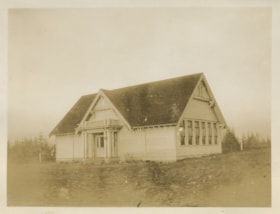
Second Street School
https://search.heritageburnaby.ca/link/museumdescription1262
- Repository
- Burnaby Village Museum
- Date
- 1913
- Collection/Fonds
- Burnaby Village Museum Photograph collection
- Description Level
- Item
- Physical Description
- 1 photograph : sepia ; 8 x 10.5 cm
- Scope and Content
- Photograph of Second Street School taken from a distance.
- Repository
- Burnaby Village Museum
- Collection/Fonds
- Burnaby Village Museum Photograph collection
- Description Level
- Item
- Physical Description
- 1 photograph : sepia ; 8 x 10.5 cm
- Scope and Content
- Photograph of Second Street School taken from a distance.
- Subjects
- Buildings - Schools
- Names
- Second Street School
- Geographic Access
- 2nd Street
- Street Address
- 7502 2nd Street
- Accession Code
- BV997.21.12
- Access Restriction
- No restrictions
- Date
- 1913
- Media Type
- Photograph
- Historic Neighbourhood
- East Burnaby (Historic Neighbourhood)
- Planning Study Area
- Second Street Area
- Scan Resolution
- 600
- Scan Date
- 01-Jun-09
- Scale
- 100
- Notes
- Title based on contents of photograph
- Note on verso of photograph: "SECOND STREET SCHOOL 1913 / Nina Chapman/ (Atkinson) / 521-0370"
Images
