Narrow Results By
Subject
- Advertising Medium - Signs and Signboards 2
- Buildings - Civic 4
- Buildings - Commercial - Restaurants 2
- Buildings - Recreational 20
- Buildings - Recreational - Bandstands 1
- Buildings - Recreational - Bowling Alleys
- Buildings - Recreational - Community Halls 7
- Buildings - Recreational - Outdoor Swimming Pools 2
- Buildings - Recreational - Swimming Pools 2
- Buildings - Religious - Churches
- Documentary Artifacts - Postcards 3
- Geographic Features - Automobile Parking Lots 1
Digney Film 3 - Construction and opening of Digney bowling Alley, visit to Stanley Park and summer vacations
https://search.heritageburnaby.ca/link/museumdescription10678
- Repository
- Burnaby Village Museum
- Date
- [between 1955 and 1979] (date of original), copied 2019
- Collection/Fonds
- Digney Family fonds
- Description Level
- File
- Physical Description
- 1 video recording (mp4) (20 min., 30 sec.) : digital, 16 fps, col., si.
- Scope and Content
- File consists of a film compliation of short clips created by Andy Digney and his son Ernest "Dig" Digney. Film compilation documents the construction, opening and a tournament of the Digney Bowling Alley located at 6521 Bonsor Avenue in Burnaby along with Digney family outings at Stanley Park in V…
- Repository
- Burnaby Village Museum
- Collection/Fonds
- Digney Family fonds
- Description Level
- File
- Physical Description
- 1 video recording (mp4) (20 min., 30 sec.) : digital, 16 fps, col., si.
- Scope and Content
- File consists of a film compliation of short clips created by Andy Digney and his son Ernest "Dig" Digney. Film compilation documents the construction, opening and a tournament of the Digney Bowling Alley located at 6521 Bonsor Avenue in Burnaby along with Digney family outings at Stanley Park in Vancouver and vacations at Birch Bay, Washington State and Okanagan Lake.
- Creator
- Digney, Andy
- Names
- Digney, Andy
- Swan, Sydney
- Digney Bowling Alley
- Digney, Drew
- Digney, Joyce
- Digney, Bruce
- Digney, Paul
- Geographic Access
- Bonsor Avenue
- Street Address
- 6521 Bonsor Avenue
- Accession Code
- BV019.18.5
- Access Restriction
- No restrictions
- Reproduction Restriction
- No known restrictions
- Date
- [between 1955 and 1979] (date of original), copied 2019
- Media Type
- Moving Images
- Historic Neighbourhood
- Central Park (Historic Neighbourhood)
- Planning Study Area
- Maywood Area
- Notes
- Title based on contents of film compilation
- 4 film segments from this compilation are described at item level and available for viewing on Heritage Burnaby.
- Contact Burnaby Village Museum to view entire content
Hastings Bowl
https://search.heritageburnaby.ca/link/archivedescription79249
- Repository
- City of Burnaby Archives
- Date
- October, 1976
- Collection/Fonds
- Burnaby Public Library Contemporary Visual Archive Project
- Description Level
- Item
- Physical Description
- 1 photograph : b&w ; 11 x 16 cm mounted on cardboard
- Scope and Content
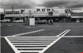
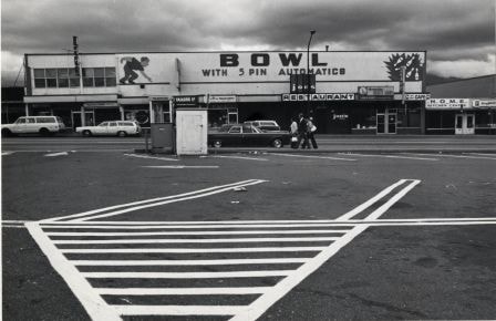
- Photograph shows Hastings Bowl at 4437 Hastings Street - a bowling alley owned by Jupiter Bowling Lanes Ltd. The alley is located abover several small shops and restaurants.
- Repository
- City of Burnaby Archives
- Date
- October, 1976
- Collection/Fonds
- Burnaby Public Library Contemporary Visual Archive Project
- Physical Description
- 1 photograph : b&w ; 11 x 16 cm mounted on cardboard
- Description Level
- Item
- Record No.
- 556-221
- Access Restriction
- No restrictions
- Reproduction Restriction
- Reproduce for fair dealing purposes only
- Accession Number
- 2013-13
- Scope and Content
- Photograph shows Hastings Bowl at 4437 Hastings Street - a bowling alley owned by Jupiter Bowling Lanes Ltd. The alley is located abover several small shops and restaurants.
- Names
- Hastings Bowl
- Media Type
- Photograph
- Photographer
- Cook, Alan
- Notes
- Scope note taken directly from BPL photograph description.
- 1 b&w copy negative : 10 x 12.5 cm accompanying
- Geographic Access
- Hastings Street
- Street Address
- 4437 Hastings Street
- Historic Neighbourhood
- Vancouver Heights (Historic Neighbourhood)
- Planning Study Area
- Burnaby Heights Area
Images

Kingsway
https://search.heritageburnaby.ca/link/archivedescription35874
- Repository
- City of Burnaby Archives
- Date
- 1900 (date of original), copied 1986
- Collection/Fonds
- Burnaby Historical Society fonds
- Description Level
- Item
- Physical Description
- 1 photograph : b&w ; 12.7 x 17.8 cm print
- Scope and Content
- Photograph of Kingsway (then Westminster Road), looking east from Boundary Road near Central Park. Included in the photograph; Central Park Presbyterian Church, Masonic Hall and Reid's Hall.
- Repository
- City of Burnaby Archives
- Date
- 1900 (date of original), copied 1986
- Collection/Fonds
- Burnaby Historical Society fonds
- Subseries
- Pioneer Tales subseries
- Physical Description
- 1 photograph : b&w ; 12.7 x 17.8 cm print
- Description Level
- Item
- Record No.
- 204-733
- Access Restriction
- No restrictions
- Reproduction Restriction
- No known restrictions
- Accession Number
- BHS1988-03
- Scope and Content
- Photograph of Kingsway (then Westminster Road), looking east from Boundary Road near Central Park. Included in the photograph; Central Park Presbyterian Church, Masonic Hall and Reid's Hall.
- Subjects
- Buildings - Recreational - Community Halls
- Buildings - Religious - Churches
- Geographic Features - Roads
- Media Type
- Photograph
- Notes
- Title based on contents of photograph
- Geographic Access
- Westminster Avenue
- Kingsway
- Street Address
- 3777 Kingsway
- Historic Neighbourhood
- Central Park (Historic Neighbourhood)
- Planning Study Area
- Garden Village Area
Images
