Narrow Results By
Subject
- Advertising Medium - Signs and Signboards 4
- Buildings - Civic 2
- Buildings - Commercial - Bakeries 1
- Buildings - Commercial - Banks 1
- Buildings - Commercial - Grocery Stores 2
- Buildings - Commercial - Restaurants 23
- Buildings - Recreational 2
- Celebrations 1
- Documentary Artifacts - Postcards 1
- Geographic Features - Automobile Parking Lots 1
- Geographic Features - Parks 1
- Industries - Tourism 1
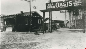
![The Oasis Suburban Café, [192-] thumbnail](/media/hpo/_Data/_Archives_Images/_Unrestricted/316/326-001.jpg?width=280)
The Oasis Suburban Café
https://search.heritageburnaby.ca/link/archivedescription37171
- Repository
- City of Burnaby Archives
- Date
- [192-]
- Collection/Fonds
- Burnaby Historical Society fonds
- Description Level
- Item
- Physical Description
- 1 photograph : sepia postcard ; 9.5 x 14 cm
- Scope and Content
- Photographic postcard of "'THE OASIS,' SUBURBAN CAFE" on Kingsway.
- Repository
- City of Burnaby Archives
- Date
- [192-]
- Collection/Fonds
- Burnaby Historical Society fonds
- Subseries
- Patterson family subseries
- Physical Description
- 1 photograph : sepia postcard ; 9.5 x 14 cm
- Description Level
- Item
- Record No.
- 326-001
- Access Restriction
- No restrictions
- Reproduction Restriction
- No known restrictions
- Accession Number
- BHS1996-11
- Scope and Content
- Photographic postcard of "'THE OASIS,' SUBURBAN CAFE" on Kingsway.
- Names
- Oasis
- Media Type
- Photograph
- Notes
- Annotation on recto of postcard reads: "'THE OASIS, SUBURBAN CAFE / A place of Refinement and Good Food. - On the Highway between New Westminster and Vancouver"
- Typed on verso of postcard reads: " Vancouver, B.C. / Dear ___________/ We just had Chicken Dinner at "The Oasis" Suburban Cafe, and I must say it was a real treat, everything was so tasty. If ever you motor up to Vancouver be sure and stop there. It is right on the Pacific Highway at 2675 Kingsway East, about three miles from New Westminster, and 20 minutes run from the Hotel Vancouver."
- Geographic Access
- Kingsway
- Street Address
- 6105 Kingsway
- Planning Study Area
- Windsor Area
Images
![The Oasis Suburban Café, [192-] thumbnail](/media/hpo/_Data/_Archives_Images/_Unrestricted/316/326-001.jpg)
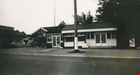
![Entrance to Oasis Tourist Camp, [192-] thumbnail](/media/hpo/_Data/_BVM_Images/1977/1977_0121_0003_001.jpg?width=280)
Entrance to Oasis Tourist Camp
https://search.heritageburnaby.ca/link/museumdescription594
- Repository
- Burnaby Village Museum
- Date
- [192-]
- Collection/Fonds
- Roy Bernard Raymer fonds
- Description Level
- Item
- Physical Description
- 1 photograph : sepia ; 8.6 x 15.1 cm
- Scope and Content
- Photograph of the entrance to Oasis Tourist Camp, which is marked by a large sign put up with two posts on either side of the sign . It reads, "Tea Gardens / The Oasis / 'Rest and Refresh' / Free Tourist Camp." Further along the driveway is a smaller sign that reads: "'Welcome.' Drive In." To the…
- Repository
- Burnaby Village Museum
- Collection/Fonds
- Roy Bernard Raymer fonds
- Description Level
- Item
- Physical Description
- 1 photograph : sepia ; 8.6 x 15.1 cm
- Scope and Content
- Photograph of the entrance to Oasis Tourist Camp, which is marked by a large sign put up with two posts on either side of the sign . It reads, "Tea Gardens / The Oasis / 'Rest and Refresh' / Free Tourist Camp." Further along the driveway is a smaller sign that reads: "'Welcome.' Drive In." To the left of the entrance is a modified house building with a sign advertising for Fraser Valley ice cream placed outside the extended patio. The Oasis Tourist Camp was located at 2675 Kingsway (after 1959 address became 6105 Kingsway) in Burnaby and was owned and operated by the Raymer family.
- Names
- Oasis
- Geographic Access
- Kingsway
- Street Address
- 6105 Kingsway
- Accession Code
- HV977.121.3
- Access Restriction
- No restrictions
- Reproduction Restriction
- No known restrictions
- Date
- [192-]
- Media Type
- Photograph
- Planning Study Area
- Windsor Area
- Scan Resolution
- 600
- Scan Date
- 23-Aug-06
- Scale
- 100
- Notes
- Title based on contents of photograph
Images
![Entrance to Oasis Tourist Camp, [192-] thumbnail](/media/hpo/_Data/_BVM_Images/1977/1977_0121_0003_001.jpg)

The Hot Dog Inn and proprietors
https://search.heritageburnaby.ca/link/archivedescription34311
- Repository
- City of Burnaby Archives
- Date
- 1924
- Collection/Fonds
- Burnaby Historical Society fonds
- Description Level
- Item
- Physical Description
- 1 photograph : b&w ; 8 x 12.9 cm on page 17.5 x 24.5 cm
- Scope and Content
- Photograph of the hot dog stand built at Deer Lake for ice skaters. Standing in front of it are the "proprietors" A. D. Bowker and Abe Rowe. The sign affixed to the stand reads: "This Is The Hot Dog Inn And It's Cold Outside / Come Right In / Coffee 5 cents / Hot Dogs 10 cents".
- Repository
- City of Burnaby Archives
- Date
- 1924
- Collection/Fonds
- Burnaby Historical Society fonds
- Subseries
- Peers family subseries
- Physical Description
- 1 photograph : b&w ; 8 x 12.9 cm on page 17.5 x 24.5 cm
- Description Level
- Item
- Record No.
- 020-018
- Access Restriction
- No restrictions
- Reproduction Restriction
- No known restrictions
- Accession Number
- BHS2007-04
- Scope and Content
- Photograph of the hot dog stand built at Deer Lake for ice skaters. Standing in front of it are the "proprietors" A. D. Bowker and Abe Rowe. The sign affixed to the stand reads: "This Is The Hot Dog Inn And It's Cold Outside / Come Right In / Coffee 5 cents / Hot Dogs 10 cents".
- Subjects
- Buildings - Commercial - Restaurants
- Structures - Tents
- Advertising Medium - Signs and Signboards
- Names
- Bowker, A.D.
- Rowe, Abe
- Media Type
- Photograph
- Notes
- Title based on caption accompanying photograph
- Geographic Access
- Deer Lake
- Historic Neighbourhood
- Burnaby Lake (Historic Neighbourhood)
- Planning Study Area
- Morley-Buckingham Area
Images

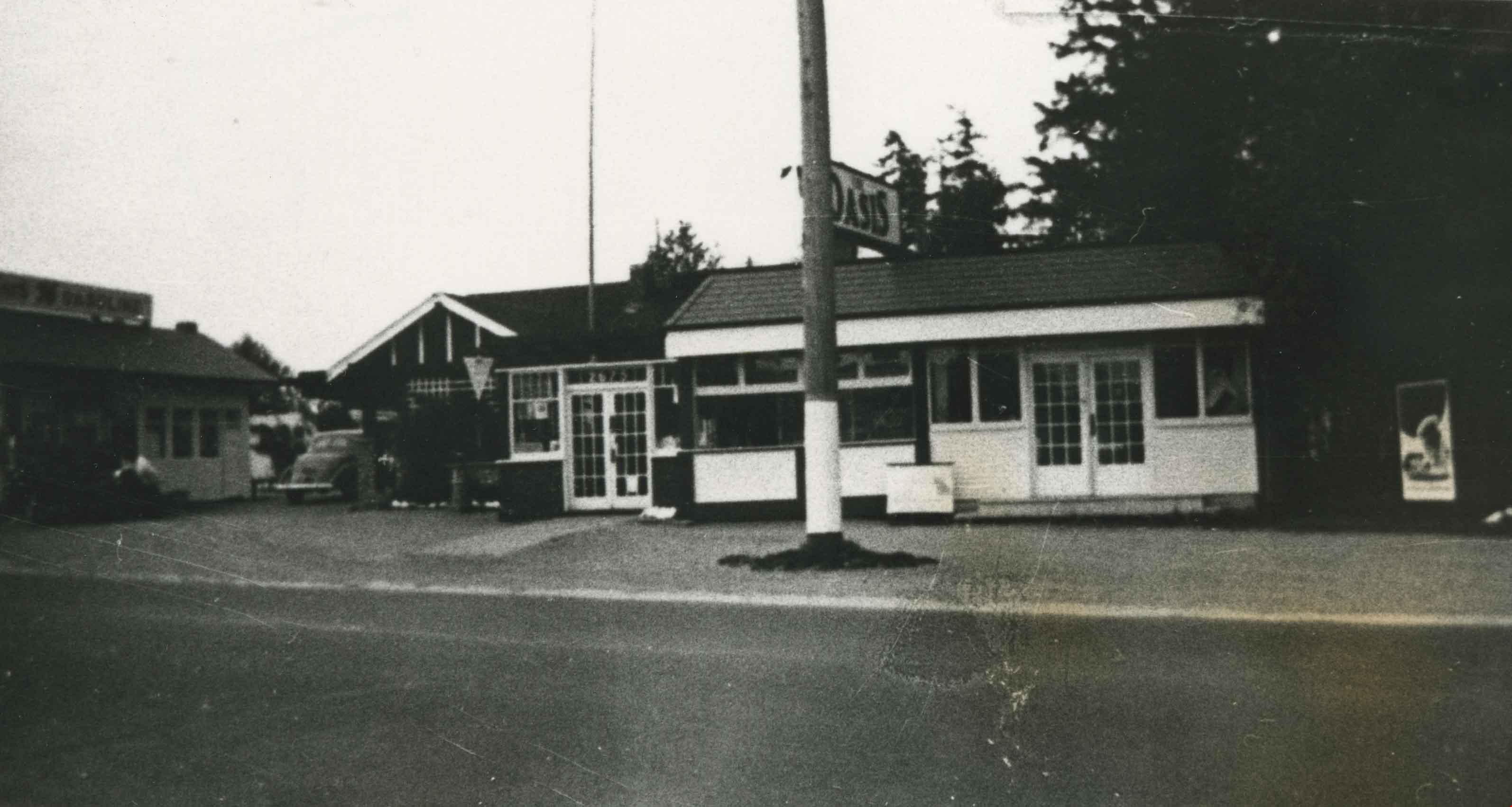
Oasis Tea Garden and Tourist Camp
https://search.heritageburnaby.ca/link/archivedescription35623
- Repository
- City of Burnaby Archives
- Date
- 1925 (date of original), copied 1986
- Collection/Fonds
- Burnaby Historical Society fonds
- Description Level
- Item
- Physical Description
- 1 photograph : b&w ; 12.7 x 17.8 cm print
- Scope and Content
- Photograph of the Oasis tea garden and tourist camp at 2675 Kingsway (Pacific Highway). It was later renumbered 6105 Kingsway. Guests could pitch tents for free at the campground and patronize the tea garden. The complex was operated by the Raymer family.
- Repository
- City of Burnaby Archives
- Date
- 1925 (date of original), copied 1986
- Collection/Fonds
- Burnaby Historical Society fonds
- Subseries
- Pioneer Tales subseries
- Physical Description
- 1 photograph : b&w ; 12.7 x 17.8 cm print
- Description Level
- Item
- Record No.
- 204-481
- Access Restriction
- No restrictions
- Reproduction Restriction
- No known restrictions
- Accession Number
- BHS1988-03
- Scope and Content
- Photograph of the Oasis tea garden and tourist camp at 2675 Kingsway (Pacific Highway). It was later renumbered 6105 Kingsway. Guests could pitch tents for free at the campground and patronize the tea garden. The complex was operated by the Raymer family.
- Names
- Oasis
- Media Type
- Photograph
- Notes
- Title based on contents of photograph
- Geographic Access
- Kingsway
- Street Address
- 6105 Kingsway
- Planning Study Area
- Windsor Area
Images

Oasis Restaurant
https://search.heritageburnaby.ca/link/archivedescription35629
- Repository
- City of Burnaby Archives
- Date
- 1926 (date of original), copied 1986
- Collection/Fonds
- Burnaby Historical Society fonds
- Description Level
- Item
- Physical Description
- 1 photograph : b&w ; 12.7 x 17.8 cm print
- Scope and Content
- Photograph of The Oasis restaurant, store, and night club (with dance floor), formerly The Oasis tea room. The Oasis was located at 2675 Kingsway (Pacific Highway). It was later renumbered 6105 Kingsway.
- Repository
- City of Burnaby Archives
- Date
- 1926 (date of original), copied 1986
- Collection/Fonds
- Burnaby Historical Society fonds
- Subseries
- Pioneer Tales subseries
- Physical Description
- 1 photograph : b&w ; 12.7 x 17.8 cm print
- Description Level
- Item
- Record No.
- 204-487
- Access Restriction
- No restrictions
- Reproduction Restriction
- No known restrictions
- Accession Number
- BHS1988-03
- Scope and Content
- Photograph of The Oasis restaurant, store, and night club (with dance floor), formerly The Oasis tea room. The Oasis was located at 2675 Kingsway (Pacific Highway). It was later renumbered 6105 Kingsway.
- Subjects
- Buildings - Commercial - Restaurants
- Names
- Oasis
- Media Type
- Photograph
- Notes
- Title based on contents of photograph
- Geographic Access
- Kingsway
- Street Address
- 6105 Kingsway
- Planning Study Area
- Windsor Area
Images

Interview with Sev Morin by Rod Fowler April 4, 1990 - Track 3
https://search.heritageburnaby.ca/link/oralhistory539
- Repository
- City of Burnaby Archives
- Date Range
- 1944-1985
- Length
- 00:03:51
- Summary
- This portion of the interview is about the lives of the three Morin brothers, Rene, Rudy and Sev; how the “Gai Paree” dance and banquet hall was started by the Morin family; and the reason for the later name changes to “Severin’s” and “Diego’s”
- Repository
- City of Burnaby Archives
- Summary
- This portion of the interview is about the lives of the three Morin brothers, Rene, Rudy and Sev; how the “Gai Paree” dance and banquet hall was started by the Morin family; and the reason for the later name changes to “Severin’s” and “Diego’s”
- Date Range
- 1944-1985
- Photo Info
- Sev Morin (left) of Severin's in Burnaby (formerly the Gai Paree) hosting a gala New Year's celebration, 1979. Item no. 480-712
- Length
- 00:03:51
- Names
- Gai Paree Supper Club
- Interviewer
- Fowler, Rod
- Interview Date
- April 4, 1990
- Scope and Content
- Recording is of an interview with Severin "Sev" Morin, conducted by Rod Fowler. Sev Morin was one of eleven participants interviewed as part of the SFU/Burnaby Centennial Committee's oral history series titled, "Voices of Burnaby". The interview is mainly about Sev Morin’s banquet hall, restaurant and night club business on Kingsway, originally named the “Gai Paree Supper Club” (1947-1976) and later “Severin’s” (1976-1985) and “Diego’s” (1985-1994), its function as a Burnaby landmark, and the entertainment and political people he met through his business. He also describes his many volunteer activities in Burnaby, including member of the SFU Senate, Rotary Club, Variety Club and Telethon, fund raising for Burnaby Hospital, and tourism related groups, and his political work for the federal Liberal party. He talks about his parents’ origins, the lives of his brothers Rudy and Rene, and the family’s involvement in establishing the “Gai Paree”. He also shares his views about the business and cultural development of Burnaby. To view “Narrow By” terms for each track expand this description and see “Notes”.
- Biographical Notes
- Severin “Sev” Rene Morin was born September 21, 1927, in Bonneville, Alberta, to Rene Pierre Morin (1878-1963) and Anne Marie (nee Lachiver) Morin (1886-1956). Mr. and Mrs. R. P. Morin and their son Rene Francois (1905-1954) immigrated to Edmonton, Alberta, from France in 1913, where Rene Pierre Morin worked for the C.N.R. and a second son Adolphe “Rudy” Ferdinand (1922-1969) was born, followed by their third son Severin. In 1943, after R.P. Morin retired, the family moved to Burnaby to a house on Sperling Avenue. Sometime earlier the two older Morin brothers found work in Trail at the smelter and developed musical careers. In 1946/47 the Morin family purchased property on Kingsway and built a banquet hall, the “Gai Paree Supper Club”. Sev and Rudy Morin managed the club and Rene F. Morin moved to Burnaby to join them with his band. The supper club, with its live music and dance floor, became a popular meeting place and wedding venue, eventually expanding into a restaurant and nightclub in the 1970s. The “Gai Paree” was renamed “Severin’s” in 1976 and “Diego’s” in 1985, closing finally in 1994. Sev Morin’s business life included three record stores which he owned with his friend Jack Cullen. Through these businesses Sev Morin was well known in the entertainment and hospitality industry. He and his restaurant also hosted political and social events that made the restaurant a community landmark. Sev Morin contributed many volunteer hours to community and charitable organizations, including an appointment to the SFU Senate, fundraising for the Burnaby Hospital, Director of the Variety Club and Rotary Club, and consultant for a variety of tourism related ventures. He also was active in the federal Liberal Party. Sev Morin and his wife Pauline married in 1950 and had three children. Sev Morin died at age 86 on March 28, 2014.
- Total Tracks
- 10
- Total Length
- 00:56:44
- Interviewee Name
- Morin, Severin "Sev"
- Interviewer Bio
- Rod Fowler returned to university as a mature student in the 1980s after working about twenty years in the field of economics and computerization in business in England, Europe and Western Canada. He graduated with a BA from SFU in both History and Sociology in 1987, his MA degree in Geography in 1989, and his PhD in Cultural Geography at SFU. He taught courses in Geography, Sociology, History and Canadian Studies at several Lower Mainland colleges, before becoming a full time member of the Geography Department at Kwantlen University College.
- Collection/Fonds
- SFU/Burnaby Centennial Committee fonds
- Transcript Available
- Transcript available
- Media Type
- Sound Recording
- Web Notes
- Interviews were digitized in 2015 allowing them to be accessible on Heritage Burnaby. The digitization project was initiated by the Community Heritage Commission with support from City of Burnaby Council.
Images

Audio Tracks
Track three of interview with Sev Morin
Track three of interview with Sev Morin
https://search.heritageburnaby.ca/media/hpo/_Data/_Archives_Oral_Histories/_Unrestricted/MSS187-021/MSS187-021_Track%203.mp3
Marine Food Basket
https://search.heritageburnaby.ca/link/archivedescription79097
- Repository
- City of Burnaby Archives
- Date
- November 14, 1976
- Collection/Fonds
- Burnaby Public Library Contemporary Visual Archive Project
- Description Level
- Item
- Physical Description
- 1 photograph : b&w ; 11 x 16 cm mounted on cardboard
- Scope and Content
- Photograph shows a large truck going past the Marine Food Basket at 5886 Marine Drive and the Hawaii Cafe next door. The buildings were constructed around 1930.
- Repository
- City of Burnaby Archives
- Date
- November 14, 1976
- Collection/Fonds
- Burnaby Public Library Contemporary Visual Archive Project
- Physical Description
- 1 photograph : b&w ; 11 x 16 cm mounted on cardboard
- Description Level
- Item
- Record No.
- 556-150
- Access Restriction
- No restrictions
- Reproduction Restriction
- Reproduce for fair dealing purposes only
- Accession Number
- 2013-13
- Scope and Content
- Photograph shows a large truck going past the Marine Food Basket at 5886 Marine Drive and the Hawaii Cafe next door. The buildings were constructed around 1930.
- Media Type
- Photograph
- Photographer
- Campbell, Peg
- Notes
- Scope note taken directly from BPL photograph description.
- 1 b&w copy negative : 10 x 12.5 cm accompanying
- Geographic Access
- Marine Drive
- Street Address
- 5886 Marine Drive
- Historic Neighbourhood
- Fraser Arm (Historic Neighbourhood)
- Planning Study Area
- Big Bend Area
Images


Manna Natural Foods
https://search.heritageburnaby.ca/link/archivedescription79117
- Repository
- City of Burnaby Archives
- Date
- September, 1976
- Collection/Fonds
- Burnaby Public Library Contemporary Visual Archive Project
- Description Level
- Item
- Physical Description
- 1 photograph : b&w ; 11 x 16 cm mounted on cardboard
- Scope and Content
- Photograph shows Manna Natural Foods at 4521 Hastings Street. The Sunshine Kitchen Restaurant is located inside the health food store.
- Repository
- City of Burnaby Archives
- Date
- September, 1976
- Collection/Fonds
- Burnaby Public Library Contemporary Visual Archive Project
- Physical Description
- 1 photograph : b&w ; 11 x 16 cm mounted on cardboard
- Description Level
- Item
- Record No.
- 556-164
- Access Restriction
- No restrictions
- Reproduction Restriction
- Reproduce for fair dealing purposes only
- Accession Number
- 2013-13
- Scope and Content
- Photograph shows Manna Natural Foods at 4521 Hastings Street. The Sunshine Kitchen Restaurant is located inside the health food store.
- Media Type
- Photograph
- Photographer
- Campbell, Peg
- Notes
- Scope note taken directly from BPL photograph description.
- 1 b&w copy negative : 10 x 12.5 cm accompanying
- Geographic Access
- Hastings Street
- Street Address
- 4521 Hastings Street
- Historic Neighbourhood
- Capitol Hill (Historic Neighbourhood)
- Planning Study Area
- Capitol Hill Area
Images

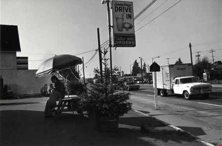
Luxury Freeze Drive-in
https://search.heritageburnaby.ca/link/archivedescription79301
- Repository
- City of Burnaby Archives
- Date
- September 23, 1976
- Collection/Fonds
- Burnaby Public Library Contemporary Visual Archive Project
- Description Level
- Item
- Physical Description
- 1 photograph : b&w ; 11 x 16 cm mounted on cardboard
- Scope and Content
- Photograph shows customers sitting outside the Luxury Freeze Drive-in at 6558 Kingsway.
- Repository
- City of Burnaby Archives
- Date
- September 23, 1976
- Collection/Fonds
- Burnaby Public Library Contemporary Visual Archive Project
- Physical Description
- 1 photograph : b&w ; 11 x 16 cm mounted on cardboard
- Description Level
- Item
- Record No.
- 556-237
- Access Restriction
- No restrictions
- Reproduction Restriction
- Reproduce for fair dealing purposes only
- Accession Number
- 2013-13
- Scope and Content
- Photograph shows customers sitting outside the Luxury Freeze Drive-in at 6558 Kingsway.
- Subjects
- Buildings - Commercial - Restaurants
- Names
- Luxury Freeze Drive-in
- Media Type
- Photograph
- Photographer
- Ross, Martha
- Notes
- Scope note taken directly from BPL photograph description.
- 1 b&w copy negative : 10 x 12.5 cm accompanying
- Geographic Access
- Kingsway
- Street Address
- 6558 Kingsway
- Historic Neighbourhood
- Edmonds (Historic Neighbourhood)
- Planning Study Area
- Kingsway-Beresford Area
Images
Captain George's Family Restaurant
https://search.heritageburnaby.ca/link/archivedescription79306
- Repository
- City of Burnaby Archives
- Date
- October, 1976
- Collection/Fonds
- Burnaby Public Library Contemporary Visual Archive Project
- Description Level
- Item
- Physical Description
- 1 photograph : b&w ; 11 x 16 cm mounted on cardboard
- Scope and Content
- Photograph shows Captain George's Family Restaurant at 5180 Lougheed Highway.
- Repository
- City of Burnaby Archives
- Date
- October, 1976
- Collection/Fonds
- Burnaby Public Library Contemporary Visual Archive Project
- Physical Description
- 1 photograph : b&w ; 11 x 16 cm mounted on cardboard
- Description Level
- Item
- Record No.
- 556-238
- Access Restriction
- No restrictions
- Reproduction Restriction
- Reproduce for fair dealing purposes only
- Accession Number
- 2013-13
- Scope and Content
- Photograph shows Captain George's Family Restaurant at 5180 Lougheed Highway.
- Subjects
- Buildings - Commercial - Restaurants
- Media Type
- Photograph
- Photographer
- Salmon, Stu
- Notes
- Scope note taken directly from BPL photograph description.
- 1 b&w copy negative : 10 x 12.5 cm accompanying
- Geographic Access
- Lougheed Highway
- Street Address
- 5180 Lougheed Highway
- Planning Study Area
- Dawson-Delta Area
Images


Dragon Inn Restaurant
https://search.heritageburnaby.ca/link/archivedescription79323
- Repository
- City of Burnaby Archives
- Date
- September 15, 1976
- Collection/Fonds
- Burnaby Public Library Contemporary Visual Archive Project
- Description Level
- Item
- Physical Description
- 1 photograph : b&w ; 11 x 16 cm mounted on cardboard
- Scope and Content
- Photograph shows the large neon sign for the Dragon Inn restaurant at 4510 Kingsway, on the corner of Kingsway and Willingdon Avenue.
- Repository
- City of Burnaby Archives
- Date
- September 15, 1976
- Collection/Fonds
- Burnaby Public Library Contemporary Visual Archive Project
- Physical Description
- 1 photograph : b&w ; 11 x 16 cm mounted on cardboard
- Description Level
- Item
- Record No.
- 556-239
- Access Restriction
- No restrictions
- Reproduction Restriction
- Reproduce for fair dealing purposes only
- Accession Number
- 2013-13
- Scope and Content
- Photograph shows the large neon sign for the Dragon Inn restaurant at 4510 Kingsway, on the corner of Kingsway and Willingdon Avenue.
- Names
- Dragon Inn
- Media Type
- Photograph
- Photographer
- McCarron, John
- Notes
- Scope note taken directly from BPL photograph description.
- 1 b&w copy negative : 10 x 12.5 cm accompanying
- Geographic Access
- Kingsway
- Street Address
- 4510 Kingsway
- Historic Neighbourhood
- Central Park (Historic Neighbourhood)
- Planning Study Area
- Marlborough Area
Images

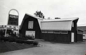
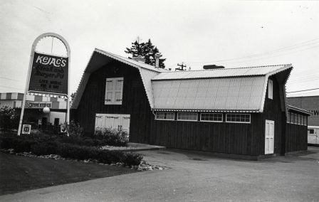
Kejac's Steak and Burger Pit
https://search.heritageburnaby.ca/link/archivedescription79324
- Repository
- City of Burnaby Archives
- Date
- October 9, 1976
- Collection/Fonds
- Burnaby Public Library Contemporary Visual Archive Project
- Description Level
- Item
- Physical Description
- 1 photograph : b&w ; 11 x 16 cm mounted on cardboard
- Scope and Content
- Photograph shows Kejac's Steak and Burger Pit at 6040 Kingsway. It was originally called the Red Barn.
- Repository
- City of Burnaby Archives
- Date
- October 9, 1976
- Collection/Fonds
- Burnaby Public Library Contemporary Visual Archive Project
- Physical Description
- 1 photograph : b&w ; 11 x 16 cm mounted on cardboard
- Description Level
- Item
- Record No.
- 556-240
- Access Restriction
- No restrictions
- Reproduction Restriction
- Reproduce for fair dealing purposes only
- Accession Number
- 2013-13
- Scope and Content
- Photograph shows Kejac's Steak and Burger Pit at 6040 Kingsway. It was originally called the Red Barn.
- Subjects
- Buildings - Commercial - Restaurants
- Media Type
- Photograph
- Photographer
- McCarron, John
- Notes
- Scope note taken directly from BPL photograph description.
- 1 b&w copy negative : 10 x 12.5 cm accompanying
- Geographic Access
- Kingsway
- Street Address
- 6040 Kingsway
- Planning Study Area
- Windsor Area
Images
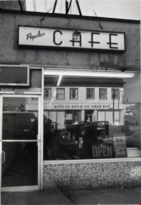
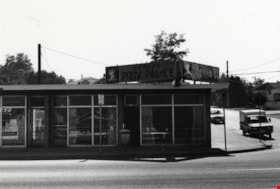
Popular Cafe
https://search.heritageburnaby.ca/link/archivedescription79325
- Repository
- City of Burnaby Archives
- Date
- October, 1976
- Collection/Fonds
- Burnaby Public Library Contemporary Visual Archive Project
- Description Level
- Item
- Physical Description
- 1 photograph : b&w ; 11 x 16 cm mounted on cardboard
- Scope and Content
- Photograph shows the Popular Cafe at 4010 Hastings Street.
- Repository
- City of Burnaby Archives
- Date
- October, 1976
- Collection/Fonds
- Burnaby Public Library Contemporary Visual Archive Project
- Physical Description
- 1 photograph : b&w ; 11 x 16 cm mounted on cardboard
- Description Level
- Item
- Record No.
- 556-241
- Access Restriction
- No restrictions
- Reproduction Restriction
- Reproduce for fair dealing purposes only
- Accession Number
- 2013-13
- Scope and Content
- Photograph shows the Popular Cafe at 4010 Hastings Street.
- Subjects
- Buildings - Commercial - Restaurants
- Names
- Popular Cafe
- Media Type
- Photograph
- Photographer
- Cook, Alan
- Notes
- Scope note taken directly from BPL photograph description.
- 1 b&w copy negative : 10 x 12.5 cm accompanying
- Geographic Access
- Hastings Street
- Street Address
- 4010 Hastings Street
- Historic Neighbourhood
- Vancouver Heights (Historic Neighbourhood)
- Planning Study Area
- Willingdon Heights Area
Images
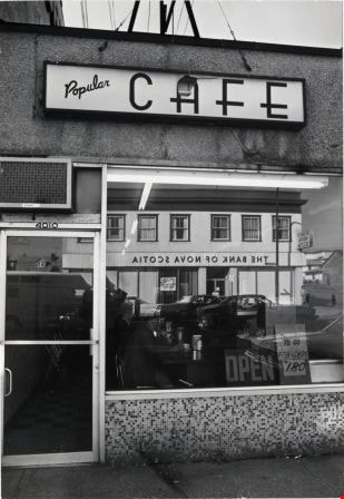
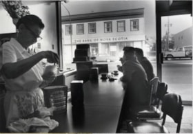
Popular Cafe
https://search.heritageburnaby.ca/link/archivedescription79326
- Repository
- City of Burnaby Archives
- Date
- October 1976
- Collection/Fonds
- Burnaby Public Library Contemporary Visual Archive Project
- Description Level
- Item
- Physical Description
- 1 photograph : b&w ; 11 x 16 cm mounted on cardboard
- Scope and Content
- Photograph shows the interior of the Popular Cafe at 4010 Hastings Street. The Bank of Nova Scotia can been seen across the street through the Cafe window.
- Repository
- City of Burnaby Archives
- Date
- October 1976
- Collection/Fonds
- Burnaby Public Library Contemporary Visual Archive Project
- Physical Description
- 1 photograph : b&w ; 11 x 16 cm mounted on cardboard
- Description Level
- Item
- Record No.
- 556-242
- Access Restriction
- No restrictions
- Reproduction Restriction
- Reproduce for fair dealing purposes only
- Accession Number
- 2013-13
- Scope and Content
- Photograph shows the interior of the Popular Cafe at 4010 Hastings Street. The Bank of Nova Scotia can been seen across the street through the Cafe window.
- Media Type
- Photograph
- Photographer
- Cook, Alan
- Notes
- Scope note taken directly from BPL photograph description.
- 1 b&w copy negative : 10 x 12.5 cm accompanying
- Geographic Access
- Hastings Street
- Street Address
- 4010 Hastings Street
- Historic Neighbourhood
- Vancouver Heights (Historic Neighbourhood)
- Planning Study Area
- Willingdon Heights Area
Images

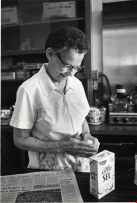
Popular Cafe
https://search.heritageburnaby.ca/link/archivedescription79327
- Repository
- City of Burnaby Archives
- Date
- October, 1976
- Collection/Fonds
- Burnaby Public Library Contemporary Visual Archive Project
- Description Level
- Item
- Physical Description
- 1 photograph : b&w ; 11 x 16 cm mounted on cardboard
- Scope and Content
- Photograph shows an unidentified waitress inside the Popular Cafe at 4010 Hastings Street.
- Repository
- City of Burnaby Archives
- Date
- October, 1976
- Collection/Fonds
- Burnaby Public Library Contemporary Visual Archive Project
- Physical Description
- 1 photograph : b&w ; 11 x 16 cm mounted on cardboard
- Description Level
- Item
- Record No.
- 556-243
- Access Restriction
- No restrictions
- Reproduction Restriction
- Reproduce for fair dealing purposes only
- Accession Number
- 2013-13
- Scope and Content
- Photograph shows an unidentified waitress inside the Popular Cafe at 4010 Hastings Street.
- Subjects
- Buildings - Commercial - Restaurants
- Names
- Popular Cafe
- Media Type
- Photograph
- Photographer
- Cook, Alan
- Notes
- Scope note taken directly from BPL photograph description.
- 1 b&w copy negative : 10 x 12.5 cm accompanying
- Geographic Access
- Hastings Street
- Street Address
- 4010 Hastings Street
- Historic Neighbourhood
- Vancouver Heights (Historic Neighbourhood)
- Planning Study Area
- Willingdon Heights Area
Images
Paddy's Pizza Place
https://search.heritageburnaby.ca/link/archivedescription79328
- Repository
- City of Burnaby Archives
- Date
- September 16, 1976
- Collection/Fonds
- Burnaby Public Library Contemporary Visual Archive Project
- Description Level
- Item
- Physical Description
- 1 photograph : b&w ; 11 x 16 cm mounted on cardboard
- Scope and Content
- Photograph shows Paddy's Pizza Place, a restaurant located on Hastings Street at Grove Avenue, built in 1968.
- Repository
- City of Burnaby Archives
- Date
- September 16, 1976
- Collection/Fonds
- Burnaby Public Library Contemporary Visual Archive Project
- Physical Description
- 1 photograph : b&w ; 11 x 16 cm mounted on cardboard
- Description Level
- Item
- Record No.
- 556-244
- Access Restriction
- No restrictions
- Reproduction Restriction
- Reproduce for fair dealing purposes only
- Accession Number
- 2013-13
- Scope and Content
- Photograph shows Paddy's Pizza Place, a restaurant located on Hastings Street at Grove Avenue, built in 1968.
- Subjects
- Buildings - Commercial - Restaurants
- Names
- Paddy's Pizza Place
- Media Type
- Photograph
- Photographer
- Born, A. J.
- Notes
- Scope note taken directly from BPL photograph description.
- 1 b&w copy negative : 10 x 12.5 cm accompanying
- Geographic Access
- Hastings Street
- Grove Avenue
- Historic Neighbourhood
- Lochdale (Historic Neighbourhood)
- Planning Study Area
- Lochdale Area
Images

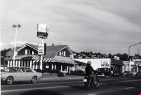
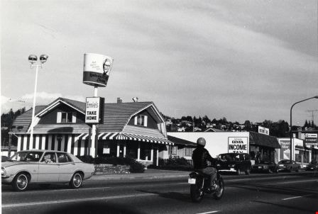
Ernie's Take Home
https://search.heritageburnaby.ca/link/archivedescription79330
- Repository
- City of Burnaby Archives
- Date
- November 1, 1976
- Collection/Fonds
- Burnaby Public Library Contemporary Visual Archive Project
- Description Level
- Item
- Physical Description
- 1 photograph : b&w ; 11 x 16 cm mounted on cardboard
- Scope and Content
- Photograph shows Ernie's Take Home at 4605 Hastings Street with its large sign advertising Kentucky Fried Chicken in a bucket. Other businesses to the east are visible as well.
- Repository
- City of Burnaby Archives
- Date
- November 1, 1976
- Collection/Fonds
- Burnaby Public Library Contemporary Visual Archive Project
- Physical Description
- 1 photograph : b&w ; 11 x 16 cm mounted on cardboard
- Description Level
- Item
- Record No.
- 556-245
- Access Restriction
- No restrictions
- Reproduction Restriction
- Reproduce for fair dealing purposes only
- Accession Number
- 2013-13
- Scope and Content
- Photograph shows Ernie's Take Home at 4605 Hastings Street with its large sign advertising Kentucky Fried Chicken in a bucket. Other businesses to the east are visible as well.
- Subjects
- Buildings - Commercial - Restaurants
- Names
- Ernie's Take Home
- Media Type
- Photograph
- Notes
- Scope note taken directly from BPL photograph description.
- 1 b&w copy negative : 10 x 12.5 cm accompanying
- Photographers identified by surnames only: Carr and Vardeman
- Geographic Access
- Hastings Street
- Street Address
- 4605 Hastings Street
- Historic Neighbourhood
- Capitol Hill (Historic Neighbourhood)
- Planning Study Area
- Capitol Hill Area
Images

Smitty's Restaurant
https://search.heritageburnaby.ca/link/archivedescription79331
- Repository
- City of Burnaby Archives
- Date
- September 5, 1976
- Collection/Fonds
- Burnaby Public Library Contemporary Visual Archive Project
- Description Level
- Item
- Physical Description
- 1 photograph : b&w ; 11 x 16 cm mounted on cardboard
- Scope and Content
- Photograph shows a sign advertising Smitty's restaurant with smaller "Welcome to Burnaby" sign below, on Hastings Street near Boundary Road. A transmission tower is on the right.
- Repository
- City of Burnaby Archives
- Date
- September 5, 1976
- Collection/Fonds
- Burnaby Public Library Contemporary Visual Archive Project
- Physical Description
- 1 photograph : b&w ; 11 x 16 cm mounted on cardboard
- Description Level
- Item
- Record No.
- 556-246
- Access Restriction
- No restrictions
- Reproduction Restriction
- Reproduce for fair dealing purposes only
- Accession Number
- 2013-13
- Scope and Content
- Photograph shows a sign advertising Smitty's restaurant with smaller "Welcome to Burnaby" sign below, on Hastings Street near Boundary Road. A transmission tower is on the right.
- Names
- Smitty's Restaurant
- Media Type
- Photograph
- Notes
- Scope note taken directly from BPL photograph description.
- 1 b&w copy negative : 10 x 12.5 cm accompanying
- Photographers identified by surnames only: Carr and Vardeman
- Geographic Access
- Hastings Street
- Boundary Road
- Historic Neighbourhood
- Vancouver Heights (Historic Neighbourhood)
- Planning Study Area
- Willingdon Heights Area
Images


Burnaby Mountain Park Pavilion Building
https://search.heritageburnaby.ca/link/archivedescription93642
- Repository
- City of Burnaby Archives
- Date
- November 19, 1977
- Collection/Fonds
- Burnaby Public Library Contemporary Visual Archive Project
- Description Level
- Item
- Physical Description
- 1 photograph : b&w ; 12.5 x 17.5 cm
- Scope and Content
- Photograph of the Burnaby Centennial Pavilion in Burnaby Mountain Park. The pavilion was built in 1958 for the British Columbia Centenary and became Horizons Restaurant in 1986 and may have housed The Owl and the Oarsman Restaurant at this time. Two individuals are standing on the deck and looking …
- Repository
- City of Burnaby Archives
- Date
- November 19, 1977
- Collection/Fonds
- Burnaby Public Library Contemporary Visual Archive Project
- Physical Description
- 1 photograph : b&w ; 12.5 x 17.5 cm
- Description Level
- Item
- Record No.
- 556-599
- Access Restriction
- No restrictions
- Reproduction Restriction
- Reproduce for fair dealing purposes only
- Accession Number
- 2017-57
- Scope and Content
- Photograph of the Burnaby Centennial Pavilion in Burnaby Mountain Park. The pavilion was built in 1958 for the British Columbia Centenary and became Horizons Restaurant in 1986 and may have housed The Owl and the Oarsman Restaurant at this time. Two individuals are standing on the deck and looking toward the mountains. The photograph is taken from across the lawn, facing north of northwest.
- Media Type
- Photograph
- Photographer
- McGillivray, Don
- Notes
- Title taken from project information form
- Accompanied by a project information form and 1 photograph (b&w negative ; 9.5 x 12.5 cm)
- BPL no. 49
- Geographic Access
- Burnaby Mountain Conservation Area
- Street Address
- 100 Centennial Way
- Planning Study Area
- Burnaby Mountain Area
Images


Bakery Opposite Capitol Hill School
https://search.heritageburnaby.ca/link/archivedescription93647
- Repository
- City of Burnaby Archives
- Date
- November 20, 1977
- Collection/Fonds
- Burnaby Public Library Contemporary Visual Archive Project
- Description Level
- Item
- Physical Description
- 1 photograph : b&w ; 12.5 x 17.5 cm
- Scope and Content
- Photograph of the exterior and the parking lot of a bakery on the corner of Holdom Avenue and Hastings Street, across from Capitol Hill Elementary School. The sign reads "Mackey Fine Foods." The photograph is taken facing north from the other side of Hastings Street.
- Repository
- City of Burnaby Archives
- Date
- November 20, 1977
- Collection/Fonds
- Burnaby Public Library Contemporary Visual Archive Project
- Physical Description
- 1 photograph : b&w ; 12.5 x 17.5 cm
- Description Level
- Item
- Record No.
- 556-604
- Access Restriction
- No restrictions
- Reproduction Restriction
- Reproduce for fair dealing purposes only
- Accession Number
- 2017-57
- Scope and Content
- Photograph of the exterior and the parking lot of a bakery on the corner of Holdom Avenue and Hastings Street, across from Capitol Hill Elementary School. The sign reads "Mackey Fine Foods." The photograph is taken facing north from the other side of Hastings Street.
- Media Type
- Photograph
- Photographer
- Chapman, Fred
- Notes
- Title taken from project information form
- Accompanied by a project information form and 1 photograph (b&w negative ; 9.5 x 12.5 cm)
- BPL no. 54
- Geographic Access
- Holdom Avenue
- Hastings Street
- Historic Neighbourhood
- Capitol Hill (Historic Neighbourhood)
- Planning Study Area
- Capitol Hill Area
Images
