Narrow Results By
Subject
- Agriculture - Crops 2
- Agriculture - Farms 4
- Animals - Cows 1
- Animals - Dogs 2
- Animals - Horses 1
- Buildings - Agricultural - Barns 1
- Buildings - Commercial 5
- Buildings - Industrial 1
- Buildings - Industrial - Powerhouses 1
- Buildings - Religious - Churches 2
- Buildings - Residential 1
- Buildings - Residential - Houses 3

Broadview Neighbourhood
https://search.heritageburnaby.ca/link/landmark687
- Repository
- Burnaby Heritage Planning
- Associated Dates
- 1925-1954
- Heritage Value
- Development in the Broadview area slowed during World War Two, but after the war, the area became home to a number of industrial sites. The first major plant to be built here was the Dominion Bridge Company which opened in 1930.
- Historic Neighbourhood
- Broadview (Historic Neighbourhood)
- Planning Study Area
- Cascade-Schou Area
Images


Broadview Neighbourhood
https://search.heritageburnaby.ca/link/landmark750
- Repository
- Burnaby Heritage Planning
- Associated Dates
- 1905-1924
- Heritage Value
- Between 1905 and 1924, the Broadview neighbourhood in Burnaby was settled by almost 100 families who saw the advantage of living in an area that was served by two railway lines - the B.C. Electric Railway and the Great Northern Railway. Touted as being only a 20 minute car ride to the city centre, this neighbourhood expanded during the early 1920s with the promise of a new direct access road to the city being built by the Great Northern Railway company and new blocks being opened up on two government reserves adjoining it.
- Historic Neighbourhood
- Broadview (Historic Neighbourhood)
- Planning Study Area
- Cascade-Schou Area
Images


Cascade-Schou Neighbourhood
https://search.heritageburnaby.ca/link/landmark798
- Repository
- Burnaby Heritage Planning
- Associated Dates
- 1955-2008
- Heritage Value
- The Cascade-Schou neighbourhood, sometimes referred to as the Cascade Heights area, includes both the Burnaby General Hospital site, the Discovery Park facilities and is bordered on its eastern boundary by BCIT. Despite these health and science developments, the neighbourhood can still be considered to be a residential community. The housing stock includes single family homes as well as newer multi-family residences that developed throughout the 1980s and 1990s.
- Historic Neighbourhood
- Broadview (Historic Neighbourhood)
- Planning Study Area
- Cascade-Schou Area
Images


West Central Valley Neighbourhood
https://search.heritageburnaby.ca/link/landmark778
- Repository
- Burnaby Heritage Planning
- Associated Dates
- 1955-2008
- Heritage Value
- The West Central Valley Neighbourhood is home to the Bridge Business Park and is a primarily industrial neighbourhood. Similar to the adjacent Dawson-Delta Neighbourhood, West Central Valley offers businesses convenient access to major roads and highways.
- Historic Neighbourhood
- Broadview (Historic Neighbourhood)
- Planning Study Area
- West Central Valley Area
Images

#221-3823 Henning Dr, Burnaby
https://search.heritageburnaby.ca/link/archivedescription94353
- Repository
- City of Burnaby Archives
- Date
- 1998
- Collection/Fonds
- Grover, Elliott & Co. Ltd. fonds
- Description Level
- File
- Physical Description
- 10 photographs : col. negatives ; 35 mm
- Scope and Content
- Photographs of the exterior of a two-storey commercial building located at 3823 Henning Drive.
- Repository
- City of Burnaby Archives
- Date
- 1998
- Collection/Fonds
- Grover, Elliott & Co. Ltd. fonds
- Physical Description
- 10 photographs : col. negatives ; 35 mm
- Description Level
- File
- Record No.
- 622-138
- Access Restriction
- No restrictions
- Reproduction Restriction
- No restrictions
- Accession Number
- 2017-39
- Scope and Content
- Photographs of the exterior of a two-storey commercial building located at 3823 Henning Drive.
- Subjects
- Buildings - Residential
- Media Type
- Photograph
- Notes
- Transcribed title
- Title transcribed from envelope photographs were originally housed in
- File no. 98-247-B
- Geographic Access
- Henning Drive
- Street Address
- 3823 Henning Drive
- Historic Neighbourhood
- Broadview (Historic Neighbourhood)
- Planning Study Area
- West Central Valley Area
2238 South Gilmore Ave
https://search.heritageburnaby.ca/link/archivedescription94329
- Repository
- City of Burnaby Archives
- Date
- 1995
- Collection/Fonds
- Grover, Elliott & Co. Ltd. fonds
- Description Level
- File
- Physical Description
- 36 photographs : col. negatives ; 35 mm
- Scope and Content
- Photographs of a truck trailor parking lot located at 2238 Gilmore Avenue (an address that no longer exists) and the surrounding industrial area of Gilmore Avenue and Henning Drive. File also includes photographs of the Gilmore Avenue railroad crossing one block north of Still Creek Avenue.
- Repository
- City of Burnaby Archives
- Date
- 1995
- Collection/Fonds
- Grover, Elliott & Co. Ltd. fonds
- Physical Description
- 36 photographs : col. negatives ; 35 mm
- Description Level
- File
- Record No.
- 622-114
- Access Restriction
- No restrictions
- Reproduction Restriction
- No restrictions
- Accession Number
- 2017-39
- Scope and Content
- Photographs of a truck trailor parking lot located at 2238 Gilmore Avenue (an address that no longer exists) and the surrounding industrial area of Gilmore Avenue and Henning Drive. File also includes photographs of the Gilmore Avenue railroad crossing one block north of Still Creek Avenue.
- Media Type
- Photograph
- Notes
- Transcribed title
- Title transcribed from envelope photographs were originally housed in
- File no. 95-027-B
- Geographic Access
- Gilmore Avenue
- Historic Neighbourhood
- Broadview (Historic Neighbourhood)
- Planning Study Area
- West Central Valley Area
3710 1st Ave
https://search.heritageburnaby.ca/link/archivedescription94330
- Repository
- City of Burnaby Archives
- Date
- February 1995
- Collection/Fonds
- Grover, Elliott & Co. Ltd. fonds
- Description Level
- File
- Physical Description
- 22 photographs : col. negatives ; 35 mm
- Scope and Content
- Photographs of the commercial property located at 3710 1st Avenue and the intersection at 1st Avenue and Boundary Road.
- Repository
- City of Burnaby Archives
- Date
- February 1995
- Collection/Fonds
- Grover, Elliott & Co. Ltd. fonds
- Physical Description
- 22 photographs : col. negatives ; 35 mm
- Description Level
- File
- Record No.
- 622-115
- Access Restriction
- No restrictions
- Reproduction Restriction
- No restrictions
- Accession Number
- 2017-39
- Scope and Content
- Photographs of the commercial property located at 3710 1st Avenue and the intersection at 1st Avenue and Boundary Road.
- Media Type
- Photograph
- Photographer
- Young, Richard
- Notes
- Transcribed title
- Title transcribed from envelope photographs were originally housed in
- File no. 95-054-B
- Geographic Access
- 1st Avenue
- Boundary Road
- Street Address
- 3710 1st Avenue
- Historic Neighbourhood
- Broadview (Historic Neighbourhood)
- Planning Study Area
- West Central Valley Area
3735-3765 and 3815-3835 First Ave
https://search.heritageburnaby.ca/link/archivedescription93753
- Repository
- City of Burnaby Archives
- Date
- March 25, 1992
- Collection/Fonds
- Grover, Elliott & Co. Ltd. fonds
- Description Level
- File
- Physical Description
- 47 photographs : col. negatives ; 35 mm
- Scope and Content
- Photographs of the commercial-industrial buildings and loading bays located at 3735-3765 and 3815-3835 1st Avenue.
- Repository
- City of Burnaby Archives
- Date
- March 25, 1992
- Collection/Fonds
- Grover, Elliott & Co. Ltd. fonds
- Physical Description
- 47 photographs : col. negatives ; 35 mm
- Description Level
- File
- Record No.
- 622-038
- Access Restriction
- No restrictions
- Reproduction Restriction
- No restrictions
- Accession Number
- 2017-39
- Scope and Content
- Photographs of the commercial-industrial buildings and loading bays located at 3735-3765 and 3815-3835 1st Avenue.
- Subjects
- Buildings - Commercial
- Buildings - Industrial
- Transportation - Trucks
- Transportation - Automobiles
- Media Type
- Photograph
- Photographer
- Young, Richard
- Notes
- Transcribed title
- Title transcribed from envelope photographs were originally housed in
- File no. 92-139-B
- Geographic Access
- 1st Avenue
- Street Address
- 3735 1st Avenue
- 3815 1st Avenue
- Historic Neighbourhood
- Broadview (Historic Neighbourhood)
- Planning Study Area
- West Central Valley Area
3737 2nd Ave
https://search.heritageburnaby.ca/link/archivedescription94203
- Repository
- City of Burnaby Archives
- Date
- August 1993
- Collection/Fonds
- Grover, Elliott & Co. Ltd. fonds
- Description Level
- File
- Physical Description
- 22 photographs : col. negatives ; 35 mm
- Scope and Content
- Photographs of the exterior of a commercial building located at 3737 2nd Avenue.
- Repository
- City of Burnaby Archives
- Date
- August 1993
- Collection/Fonds
- Grover, Elliott & Co. Ltd. fonds
- Physical Description
- 22 photographs : col. negatives ; 35 mm
- Description Level
- File
- Record No.
- 622-078
- Access Restriction
- No restrictions
- Reproduction Restriction
- No restrictions
- Accession Number
- 2017-39
- Scope and Content
- Photographs of the exterior of a commercial building located at 3737 2nd Avenue.
- Media Type
- Photograph
- Notes
- Transcribed title
- Title transcribed from envelope photographs were originally housed in
- File no. 93-329-B
- Photographer identified as "L.D."
- Geographic Access
- 2nd Avenue
- Street Address
- 3737 2nd Avenue
- Historic Neighbourhood
- Broadview (Historic Neighbourhood)
- Planning Study Area
- West Central Valley Area
3855 Henning dr [sic]
https://search.heritageburnaby.ca/link/archivedescription94337
- Repository
- City of Burnaby Archives
- Date
- June 1995
- Collection/Fonds
- Grover, Elliott & Co. Ltd. fonds
- Description Level
- File
- Physical Description
- 19 photographs : col. negatives ; 35 mm
- Scope and Content
- Photographs of the exterior of a two-storey commercial building complex located at 3855 Henning Drive.
- Repository
- City of Burnaby Archives
- Date
- June 1995
- Collection/Fonds
- Grover, Elliott & Co. Ltd. fonds
- Physical Description
- 19 photographs : col. negatives ; 35 mm
- Description Level
- File
- Record No.
- 622-122
- Access Restriction
- No restrictions
- Reproduction Restriction
- No restrictions
- Accession Number
- 2017-39
- Scope and Content
- Photographs of the exterior of a two-storey commercial building complex located at 3855 Henning Drive.
- Subjects
- Buildings - Commercial
- Media Type
- Photograph
- Notes
- Transcribed title
- Title transcribed from envelope photographs were originally housed in
- File no. 95-194-B
- Geographic Access
- Henning Drive
- Street Address
- 3855 Henning Drive
- Historic Neighbourhood
- Broadview (Historic Neighbourhood)
- Planning Study Area
- West Central Valley Area
3855 Henning dr [sic]
https://search.heritageburnaby.ca/link/archivedescription94344
- Repository
- City of Burnaby Archives
- Date
- August 1995
- Collection/Fonds
- Grover, Elliott & Co. Ltd. fonds
- Description Level
- File
- Physical Description
- 21 photographs : col. negatives ; 35 mm
- Scope and Content
- Photographs of a two-storey commercial building located at 3855 Henning Drive.
- Repository
- City of Burnaby Archives
- Date
- August 1995
- Collection/Fonds
- Grover, Elliott & Co. Ltd. fonds
- Physical Description
- 21 photographs : col. negatives ; 35 mm
- Description Level
- File
- Record No.
- 622-129
- Access Restriction
- No restrictions
- Reproduction Restriction
- No restrictions
- Accession Number
- 2017-39
- Scope and Content
- Photographs of a two-storey commercial building located at 3855 Henning Drive.
- Subjects
- Buildings - Commercial
- Media Type
- Photograph
- Notes
- Transcribed title
- Title transcribed from envelope photographs were originally housed in
- File no. 95-269-B
- Geographic Access
- Henning Drive
- Street Address
- 3855 Henning Drive
- Historic Neighbourhood
- Broadview (Historic Neighbourhood)
- Planning Study Area
- West Central Valley Area
4010 Regent St.
https://search.heritageburnaby.ca/link/archivedescription94318
- Repository
- City of Burnaby Archives
- Date
- September 1994
- Collection/Fonds
- Grover, Elliott & Co. Ltd. fonds
- Description Level
- File
- Physical Description
- 25 photographs : col. negatives ; 35 mm
- Scope and Content
- Photographs of an undeveloped property located at 4010 Regent Street. Property is covered with soil, brush, and some trees.
- Repository
- City of Burnaby Archives
- Date
- September 1994
- Collection/Fonds
- Grover, Elliott & Co. Ltd. fonds
- Physical Description
- 25 photographs : col. negatives ; 35 mm
- Description Level
- File
- Record No.
- 622-103
- Access Restriction
- No restrictions
- Reproduction Restriction
- No restrictions
- Accession Number
- 2017-39
- Scope and Content
- Photographs of an undeveloped property located at 4010 Regent Street. Property is covered with soil, brush, and some trees.
- Subjects
- Land Clearing
- Media Type
- Photograph
- Photographer
- Young, Richard
- Notes
- Transcribed title
- Title transcribed from envelope photographs were originally housed in
- File no. 94-342-B
- Geographic Access
- Regent Street
- Street Address
- 4010 Regent Street
- Historic Neighbourhood
- Broadview (Historic Neighbourhood)
- Planning Study Area
- West Central Valley Area

Altar at St. Andrew's Anglican Church
https://search.heritageburnaby.ca/link/archivedescription38248
- Repository
- City of Burnaby Archives
- Date
- 1924
- Collection/Fonds
- Burnaby Historical Society fonds
- Description Level
- Item
- Physical Description
- 1 photograph : b&w ; 9 x 12.5 cm
- Scope and Content
- Photograph of the altar at St. Andrew's Anglican Church, prepared for Easter Sunday.
- Repository
- City of Burnaby Archives
- Date
- 1924
- Collection/Fonds
- Burnaby Historical Society fonds
- Subseries
- Margaret McCallum subseries
- Physical Description
- 1 photograph : b&w ; 9 x 12.5 cm
- Description Level
- Item
- Record No.
- 375-009
- Access Restriction
- No restrictions
- Reproduction Restriction
- No known restrictions
- Accession Number
- BHS1986-42
- Scope and Content
- Photograph of the altar at St. Andrew's Anglican Church, prepared for Easter Sunday.
- Media Type
- Photograph
- Notes
- Title based on contents of photograph.
- Geographic Access
- Gilmore Avenue
- Norfolk Street
- Historic Neighbourhood
- Broadview (Historic Neighbourhood)
- Planning Study Area
- Cascade-Schou Area
Images

![Broadview district covered in snow, [192-?] (date of original), copied 1992 thumbnail](/media/hpo/_Data/_Archives_Images/_Unrestricted/315/315-490.jpg?width=280)
Broadview district covered in snow
https://search.heritageburnaby.ca/link/archivedescription37027
- Repository
- City of Burnaby Archives
- Date
- [192-?] (date of original), copied 1992
- Collection/Fonds
- Burnaby Historical Society fonds
- Description Level
- Item
- Physical Description
- 1 photograph : b&w ; 10.1 x 14.9 cm print
- Scope and Content
- Photograph the Broadview district covered in snow. Annotation under photograph reads, "Backyard of Roma's [Richards] House / House in background is Alex Smith's"
- Repository
- City of Burnaby Archives
- Date
- [192-?] (date of original), copied 1992
- Collection/Fonds
- Burnaby Historical Society fonds
- Subseries
- Burnaby Centennial Anthology subseries
- Physical Description
- 1 photograph : b&w ; 10.1 x 14.9 cm print
- Description Level
- Item
- Record No.
- 315-490
- Access Restriction
- No restrictions
- Reproduction Restriction
- No known restrictions
- Accession Number
- BHS1994-04
- Scope and Content
- Photograph the Broadview district covered in snow. Annotation under photograph reads, "Backyard of Roma's [Richards] House / House in background is Alex Smith's"
- Subjects
- Natural Phenomena - Snow
- Media Type
- Photograph
- Notes
- Title based on contents of photograph
- Historic Neighbourhood
- Broadview (Historic Neighbourhood)
Images
![Broadview district covered in snow, [192-?] (date of original), copied 1992 thumbnail](/media/hpo/_Data/_Archives_Images/_Unrestricted/315/315-490.jpg)
![Elsie Nicholson, [1921] thumbnail](/media/hpo/_Data/_Archives_Images/_Unrestricted/371/375-002.jpg?width=280)
Elsie Nicholson
https://search.heritageburnaby.ca/link/archivedescription38241
- Repository
- City of Burnaby Archives
- Date
- [1921]
- Collection/Fonds
- Burnaby Historical Society fonds
- Description Level
- Item
- Physical Description
- 1 photograph : b&w ; 8 x 12.2 cm
- Scope and Content
- Photograph of Elsie Nicholson standing next to the horse named "Holly" at the Nicholson farm in the area of Boundary Road and the C.N.R. rail line. The barns and farm outbuildings can be seen in the background.
- Repository
- City of Burnaby Archives
- Date
- [1921]
- Collection/Fonds
- Burnaby Historical Society fonds
- Subseries
- Margaret McCallum subseries
- Physical Description
- 1 photograph : b&w ; 8 x 12.2 cm
- Description Level
- Item
- Record No.
- 375-002
- Access Restriction
- No restrictions
- Reproduction Restriction
- No known restrictions
- Accession Number
- BHS1986-42
- Scope and Content
- Photograph of Elsie Nicholson standing next to the horse named "Holly" at the Nicholson farm in the area of Boundary Road and the C.N.R. rail line. The barns and farm outbuildings can be seen in the background.
- Subjects
- Agriculture - Farms
- Occupations - Farmers
- Agriculture - Crops
- Transportation - Horses
- Animals - Dogs
- Transportation - Wagons
- Names
- Nicholson, Elsie
- Media Type
- Photograph
- Notes
- Title based on contents of photograph
- Geographic Access
- Boundary Road
- Street Address
- 2550 Boundary Road
- Historic Neighbourhood
- Broadview (Historic Neighbourhood)
- Planning Study Area
- West Central Valley Area
Images
![Elsie Nicholson, [1921] thumbnail](/media/hpo/_Data/_Archives_Images/_Unrestricted/371/375-002.jpg)
![E.W. Nicholson at his farm, [1921] thumbnail](/media/hpo/_Data/_Archives_Images/_Unrestricted/371/375-001.jpg?width=280)
E.W. Nicholson at his farm
https://search.heritageburnaby.ca/link/archivedescription38240
- Repository
- City of Burnaby Archives
- Date
- [1921]
- Collection/Fonds
- Burnaby Historical Society fonds
- Description Level
- Item
- Physical Description
- 1 photograph : b&w ; 8 x 12.5 cm
- Scope and Content
- Photograph of E.W. Nicholson, haying on his farm at Boundary Road and the Canadian National Railway tracks with his horse "Holly."
- Repository
- City of Burnaby Archives
- Date
- [1921]
- Collection/Fonds
- Burnaby Historical Society fonds
- Subseries
- Margaret McCallum subseries
- Physical Description
- 1 photograph : b&w ; 8 x 12.5 cm
- Description Level
- Item
- Record No.
- 375-001
- Access Restriction
- No restrictions
- Reproduction Restriction
- No known restrictions
- Accession Number
- BHS1986-42
- Scope and Content
- Photograph of E.W. Nicholson, haying on his farm at Boundary Road and the Canadian National Railway tracks with his horse "Holly."
- Subjects
- Agriculture - Farms
- Occupations - Farmers
- Agriculture - Crops
- Transportation - Horses
- Animals - Dogs
- Transportation - Wagons
- Names
- Nicholson, E.W.
- Media Type
- Photograph
- Notes
- Title based on contents of photograph
- Geographic Access
- Boundary Road
- Street Address
- 2550 Boundary Road
- Historic Neighbourhood
- Broadview (Historic Neighbourhood)
- Planning Study Area
- West Central Valley Area
Images
![E.W. Nicholson at his farm, [1921] thumbnail](/media/hpo/_Data/_Archives_Images/_Unrestricted/371/375-001.jpg)
![E.W. Nicholson farm, [1921] thumbnail](/media/hpo/_Data/_Archives_Images/_Unrestricted/371/375-005.jpg?width=280)
E.W. Nicholson farm
https://search.heritageburnaby.ca/link/archivedescription38244
- Repository
- City of Burnaby Archives
- Date
- [1921]
- Collection/Fonds
- Burnaby Historical Society fonds
- Description Level
- Item
- Physical Description
- 1 photograph : b&w ; 8.7 x 12.5 cm
- Scope and Content
- Photograph of cattle grazing in the field on the farm belonging to E.W. Nicholson Farm. The Roman Catholic Boys' School can be seen faintly in the background.
- Repository
- City of Burnaby Archives
- Date
- [1921]
- Collection/Fonds
- Burnaby Historical Society fonds
- Subseries
- Margaret McCallum subseries
- Physical Description
- 1 photograph : b&w ; 8.7 x 12.5 cm
- Description Level
- Item
- Record No.
- 375-005
- Access Restriction
- No restrictions
- Reproduction Restriction
- No known restrictions
- Accession Number
- BHS1986-42
- Scope and Content
- Photograph of cattle grazing in the field on the farm belonging to E.W. Nicholson Farm. The Roman Catholic Boys' School can be seen faintly in the background.
- Subjects
- Agriculture - Farms
- Animals - Cows
- Media Type
- Photograph
- Notes
- Title based on contents of photograph
- Geographic Access
- Boundary Road
- Street Address
- 2550 Boundary Road
- Historic Neighbourhood
- Broadview (Historic Neighbourhood)
- Planning Study Area
- West Central Valley Area
Images
![E.W. Nicholson farm, [1921] thumbnail](/media/hpo/_Data/_Archives_Images/_Unrestricted/371/375-005.jpg)

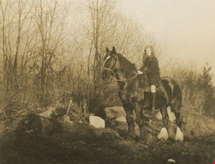
Girl on horseback
https://search.heritageburnaby.ca/link/archivedescription38264
- Repository
- City of Burnaby Archives
- Date
- 1926
- Collection/Fonds
- Burnaby Historical Society fonds
- Description Level
- Item
- Physical Description
- 1 photograph : sepia ; 8.8 x 11.3 cm
- Scope and Content
- Photograph of a young woman, possibly Margaret McCallum, sitting atop a horse in a field. This photograph was most likely taken in the Broadview are of Burnaby, where the McCallum family lived.
- Repository
- City of Burnaby Archives
- Date
- 1926
- Collection/Fonds
- Burnaby Historical Society fonds
- Subseries
- Margaret McCallum subseries
- Physical Description
- 1 photograph : sepia ; 8.8 x 11.3 cm
- Description Level
- Item
- Record No.
- 375-026
- Access Restriction
- No restrictions
- Reproduction Restriction
- No known restrictions
- Accession Number
- BHS1986-42
- Scope and Content
- Photograph of a young woman, possibly Margaret McCallum, sitting atop a horse in a field. This photograph was most likely taken in the Broadview are of Burnaby, where the McCallum family lived.
- Subjects
- Animals - Horses
- Names
- McCallum, Margaret
- Media Type
- Photograph
- Notes
- Title based on contents of photograph
- Historic Neighbourhood
- Broadview (Historic Neighbourhood)
- Planning Study Area
- West Central Valley Area
Images
Henning dr. [sic] Burnaby
https://search.heritageburnaby.ca/link/archivedescription93838
- Repository
- City of Burnaby Archives
- Date
- January 1993
- Collection/Fonds
- Grover, Elliott & Co. Ltd. fonds
- Description Level
- File
- Physical Description
- 24 photographs : col. negatives ; 35 mm
- Scope and Content
- Photographs of the Bridge Business Park under construction. The Bridge Business Park is located between Lougheed Highway and Henning Drive and Boundary Road and Gilmore Avenue.
- Repository
- City of Burnaby Archives
- Date
- January 1993
- Collection/Fonds
- Grover, Elliott & Co. Ltd. fonds
- Physical Description
- 24 photographs : col. negatives ; 35 mm
- Description Level
- File
- Record No.
- 622-063
- Access Restriction
- No restrictions
- Reproduction Restriction
- No restrictions
- Accession Number
- 2017-39
- Scope and Content
- Photographs of the Bridge Business Park under construction. The Bridge Business Park is located between Lougheed Highway and Henning Drive and Boundary Road and Gilmore Avenue.
- Subjects
- Geographic Features - Roads
- Construction
- Media Type
- Photograph
- Notes
- Transcribed title
- Title transcribed from envelope photographs were originally housed in
- File no. 93-031-B
- Photographer identified as "K.D."
- Geographic Access
- Henning Drive
- Historic Neighbourhood
- Broadview (Historic Neighbourhood)
- Planning Study Area
- West Central Valley Area
![Horne Payne Receiving Station, [1920] (date of original), copied 1986 thumbnail](/media/hpo/_Data/_Archives_Images/_Unrestricted/126/158-001.jpg?width=280)
Horne Payne Receiving Station
https://search.heritageburnaby.ca/link/archivedescription34916
- Repository
- City of Burnaby Archives
- Date
- [1920] (date of original), copied 1986
- Collection/Fonds
- Burnaby Historical Society fonds
- Description Level
- Item
- Physical Description
- 1 photograph : b&w ; 8.8 x 12.5 cm print
- Scope and Content
- Photograph of the exterior of the Horne Payne substation, Boundary Road.
- Repository
- City of Burnaby Archives
- Date
- [1920] (date of original), copied 1986
- Collection/Fonds
- Burnaby Historical Society fonds
- Subseries
- Photographs subseries
- Physical Description
- 1 photograph : b&w ; 8.8 x 12.5 cm print
- Description Level
- Item
- Record No.
- 158-001
- Access Restriction
- No restrictions
- Reproduction Restriction
- No known restrictions
- Accession Number
- BHS1986-08
- Scope and Content
- Photograph of the exterior of the Horne Payne substation, Boundary Road.
- Subjects
- Buildings - Industrial - Powerhouses
- Media Type
- Photograph
- Notes
- Caption at lower right of photograph: "Horne-Payne Receiving Station"
- Geographic Access
- 2nd Avenue
- Street Address
- 3700 2nd Avenue
- Historic Neighbourhood
- Broadview (Historic Neighbourhood)
- Planning Study Area
- West Central Valley Area
Images
![Horne Payne Receiving Station, [1920] (date of original), copied 1986 thumbnail](/media/hpo/_Data/_Archives_Images/_Unrestricted/126/158-001.jpg)