Narrow Results By
Subject
- Buildings - Industrial 1
- Buildings - Schools 2
- Clothing - Military Uniforms 1
- Documentary Artifacts 1
- Documentary Artifacts - Postcards 1
- Exhibitions 1
- Geographic Features - Roads 1
- Land Clearing 2
- Occupations - Military Personnel 1
- Persons - Students 1
- Plants - Trees 1
- Wars - World War, 1939-1945 1
![Brantford Coach and Body Ltd., [1959] thumbnail](/media/hpo/_Data/_Archives_Images/_Unrestricted/001/076-001.jpg?width=280)
Brantford Coach and Body Ltd.
https://search.heritageburnaby.ca/link/archivedescription34642
- Repository
- City of Burnaby Archives
- Date
- [1959]
- Collection/Fonds
- Burnaby Historical Society fonds
- Description Level
- Item
- Physical Description
- 1 photograph : b&w ; 20.5 x 25.7 cm
- Scope and Content
- Photograph of the exterior of Brantford Coach and Body Ltd. at 6055 Gilmore Avenue. Signs on the building show the business name and also read, "Sales" and "Service."
- Repository
- City of Burnaby Archives
- Date
- [1959]
- Collection/Fonds
- Burnaby Historical Society fonds
- Subseries
- Photographs subseries
- Physical Description
- 1 photograph : b&w ; 20.5 x 25.7 cm
- Description Level
- Item
- Record No.
- 076-001
- Access Restriction
- No restrictions
- Reproduction Restriction
- Reproduce for fair dealing purposes only
- Accession Number
- BHS2007-04
- Scope and Content
- Photograph of the exterior of Brantford Coach and Body Ltd. at 6055 Gilmore Avenue. Signs on the building show the business name and also read, "Sales" and "Service."
- Subjects
- Buildings - Industrial
- Media Type
- Photograph
- Notes
- Title based on contents of photograph
- Geographic Access
- Gilmore Avenue
- Street Address
- 6055 Gilmore Avenue
Images
![Brantford Coach and Body Ltd., [1959] thumbnail](/media/hpo/_Data/_Archives_Images/_Unrestricted/001/076-001.jpg)

Brantford Elementary School
https://search.heritageburnaby.ca/link/archivedescription62699
- Repository
- City of Burnaby Archives
- Date
- September 8, 2009
- Collection/Fonds
- Community Heritage Commission Special Projects fonds
- Description Level
- Item
- Physical Description
- 1 photograph (tiff) : col. ; 600 ppi
- Scope and Content
- Photograph of Brantford Elementary School.
- Repository
- City of Burnaby Archives
- Date
- September 8, 2009
- Collection/Fonds
- Community Heritage Commission Special Projects fonds
- Physical Description
- 1 photograph (tiff) : col. ; 600 ppi
- Description Level
- Item
- Record No.
- 503-032
- Access Restriction
- No restrictions
- Reproduction Restriction
- No restrictions
- Accession Number
- 2009-10
- Scope and Content
- Photograph of Brantford Elementary School.
- Subjects
- Buildings - Schools
- Media Type
- Photograph
- Photographer
- Pasch, Rebecca
- Notes
- Title based on contents of photograph
- Geographic Access
- Brantford Avenue
- Street Address
- 6512 Brantford Avenue
- Historic Neighbourhood
- Edmonds (Historic Neighbourhood)
- Planning Study Area
- Kingsway-Beresford Area
Images

![Brantford Elementary school crosswalk, [2004] thumbnail](/media/hpo/_Data/_Archives_Images/_Unrestricted/535/535-2054.jpg?width=280)
Brantford Elementary school crosswalk
https://search.heritageburnaby.ca/link/archivedescription96384
- Repository
- City of Burnaby Archives
- Date
- [2004]
- Collection/Fonds
- Burnaby NewsLeader photograph collection
- Description Level
- Item
- Physical Description
- 1 photograph (tiff) : col.
- Scope and Content
- Photograph of Ernie Kashima, the principal of Brantford Elementary School, standing at a school crosswalk at Sperling Avenue near the elementary school.
- Repository
- City of Burnaby Archives
- Date
- [2004]
- Collection/Fonds
- Burnaby NewsLeader photograph collection
- Physical Description
- 1 photograph (tiff) : col.
- Description Level
- Item
- Record No.
- 535-2054
- Access Restriction
- No restrictions
- Reproduction Restriction
- No restrictions
- Accession Number
- 2018-12
- Scope and Content
- Photograph of Ernie Kashima, the principal of Brantford Elementary School, standing at a school crosswalk at Sperling Avenue near the elementary school.
- Media Type
- Photograph
- Photographer
- Bartel, Mario
- Notes
- Title based on caption
- Collected by editorial for use in a March 2004 issue of the Burnaby NewsLeader
- Caption from metadata: "Ernie Kashima, the principal of Brantford Elementary School, says he pulled his school's student crossing guards from a crossing on Sperling Ave. because of fears for the guards' safety, as the street doesn't have a school speed zone."
- Geographic Access
- Sperling Avenue
- Brantford Avenue
- Street Address
- 6512 Brantford Avenue
- Historic Neighbourhood
- Edmonds (Historic Neighbourhood)
- Planning Study Area
- Kingsway-Beresford Area
Images
![Brantford Elementary school crosswalk, [2004] thumbnail](/media/hpo/_Data/_Archives_Images/_Unrestricted/535/535-2054.jpg)
![Brantford Elementary School Triceratops, [2006] thumbnail](/media/hpo/_Data/_Archives_Images/_Unrestricted/535/535-1883-2.jpg?width=280)
Brantford Elementary School Triceratops
https://search.heritageburnaby.ca/link/archivedescription96186
- Repository
- City of Burnaby Archives
- Date
- [2006]
- Collection/Fonds
- Burnaby NewsLeader photograph collection
- Description Level
- File
- Physical Description
- 2 photographs (tiff) : col.
- Scope and Content
- File contains photographs of Brantford Elementary School students viewing a life-size animatronic Triceratops that visited the school. The dinosaur is part of the Dinosaurs in Gastown exhibit at Storyeum.
- Repository
- City of Burnaby Archives
- Date
- [2006]
- Collection/Fonds
- Burnaby NewsLeader photograph collection
- Physical Description
- 2 photographs (tiff) : col.
- Description Level
- File
- Record No.
- 535-1883
- Access Restriction
- No restrictions
- Reproduction Restriction
- No restrictions
- Accession Number
- 2018-12
- Scope and Content
- File contains photographs of Brantford Elementary School students viewing a life-size animatronic Triceratops that visited the school. The dinosaur is part of the Dinosaurs in Gastown exhibit at Storyeum.
- Subjects
- Persons - Students
- Exhibitions
- Media Type
- Photograph
- Photographer
- Bartel, Mario
- Notes
- Title based on caption
- Collected by editorial for use in a January 2006 issue of the Burnaby NewsLeader
- Caption from metadata for 535-1883-1: "Students at Brantford Elementary School in Burnaby are enthralled by a prehistoric visitor, a life-size animatronic Triceratops on tour from the Dinosaurs in Gastown exhibit at Storyeum, on Tuesday."
- Caption from metadata for 535-1883-2: "A life-size animatronic model of a Triceratops on tour from the Dinosaurs in Gastown exhibit at Storyeum gets some attention as it visits Brantford Elementary School on Tuesday."
- Geographic Access
- Brantford Avenue
- Street Address
- 6512 Brantford Avenue
- Historic Neighbourhood
- Edmonds (Historic Neighbourhood)
- Planning Study Area
- Kingsway-Beresford Area
Images
![Brantford Elementary School Triceratops, [2006] thumbnail](/media/hpo/_Data/_Archives_Images/_Unrestricted/535/535-1883-2.jpg)
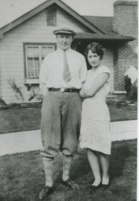
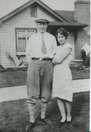
The Skattebols
https://search.heritageburnaby.ca/link/archivedescription36664
- Repository
- City of Burnaby Archives
- Date
- 1922 (date of original), copied 1992
- Collection/Fonds
- Burnaby Historical Society fonds
- Description Level
- Item
- Physical Description
- 1 photograph : b&w ; 12.5 x 8.5 cm print
- Scope and Content
- Photograph of the Skattebols on Brantford Street.
- Repository
- City of Burnaby Archives
- Date
- 1922 (date of original), copied 1992
- Collection/Fonds
- Burnaby Historical Society fonds
- Subseries
- Burnaby Centennial Anthology subseries
- Physical Description
- 1 photograph : b&w ; 12.5 x 8.5 cm print
- Description Level
- Item
- Record No.
- 315-019
- Access Restriction
- No restrictions
- Reproduction Restriction
- No known restrictions
- Accession Number
- BHS1994-04
- Scope and Content
- Photograph of the Skattebols on Brantford Street.
- Media Type
- Photograph
- Notes
- Title based on contents of photograph
- Geographic Access
- Brantford Avenue
- Street Address
- 6385 Brantford Avenue
- Historic Neighbourhood
- Edmonds (Historic Neighbourhood)
- Planning Study Area
- Kingsway-Beresford Area
Images
Woodean family
https://search.heritageburnaby.ca/link/archivedescription36661
- Repository
- City of Burnaby Archives
- Date
- 1941 (date of original), copied 1992
- Collection/Fonds
- Burnaby Historical Society fonds
- Description Level
- Item
- Physical Description
- 1 photograph : b&w ; 11.5 x 7.5 cm print
- Scope and Content
- Photograph of Gladys, Lance and Robert Woodean, children of Pearl and Ed Woodean. This photograph was taken in front of their grandparents' home on Brantford Avenue.
- Repository
- City of Burnaby Archives
- Date
- 1941 (date of original), copied 1992
- Collection/Fonds
- Burnaby Historical Society fonds
- Subseries
- Burnaby Centennial Anthology subseries
- Physical Description
- 1 photograph : b&w ; 11.5 x 7.5 cm print
- Description Level
- Item
- Record No.
- 315-016
- Access Restriction
- No restrictions
- Reproduction Restriction
- No known restrictions
- Accession Number
- BHS1994-04
- Scope and Content
- Photograph of Gladys, Lance and Robert Woodean, children of Pearl and Ed Woodean. This photograph was taken in front of their grandparents' home on Brantford Avenue.
- Media Type
- Photograph
- Notes
- Title based on contents of photograph
- Geographic Access
- Brantford Avenue
- Historic Neighbourhood
- Edmonds (Historic Neighbourhood)
- Planning Study Area
- Kingsway-Beresford Area
Images
![Woodean family, [1941] (date of original), copied 1992 thumbnail](/media/hpo/_Data/_Archives_Images/_Unrestricted/315/315-017.jpg?width=280)
Woodean family
https://search.heritageburnaby.ca/link/archivedescription36662
- Repository
- City of Burnaby Archives
- Date
- [1941] (date of original), copied 1992
- Collection/Fonds
- Burnaby Historical Society fonds
- Description Level
- Item
- Physical Description
- 1 photograph : b&w ; 12.5 x 8.5 cm print
- Scope and Content
- Photograph of Pearl and Ed Woodean with their son, Robert. Ed Woodean enlisted in 1940 and went overseas from 1942 to 1945.
- Repository
- City of Burnaby Archives
- Date
- [1941] (date of original), copied 1992
- Collection/Fonds
- Burnaby Historical Society fonds
- Subseries
- Burnaby Centennial Anthology subseries
- Physical Description
- 1 photograph : b&w ; 12.5 x 8.5 cm print
- Description Level
- Item
- Record No.
- 315-017
- Access Restriction
- No restrictions
- Reproduction Restriction
- No known restrictions
- Accession Number
- BHS1994-04
- Scope and Content
- Photograph of Pearl and Ed Woodean with their son, Robert. Ed Woodean enlisted in 1940 and went overseas from 1942 to 1945.
- Media Type
- Photograph
- Notes
- Title based on contents of photograph
- Geographic Access
- Brantford Avenue
- Historic Neighbourhood
- Edmonds (Historic Neighbourhood)
- Planning Study Area
- Kingsway-Beresford Area
Images
![Woodean family, [1941] (date of original), copied 1992 thumbnail](/media/hpo/_Data/_Archives_Images/_Unrestricted/315/315-017.jpg)
![Woodean family children, [194-] (date of original), copied 1992 thumbnail](/media/hpo/_Data/_Archives_Images/_Unrestricted/315/315-015.jpg?width=280)
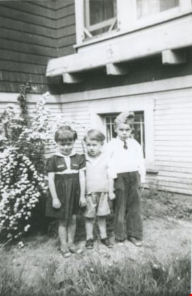
Woodean family children
https://search.heritageburnaby.ca/link/archivedescription36660
- Repository
- City of Burnaby Archives
- Date
- [194-] (date of original), copied 1992
- Collection/Fonds
- Burnaby Historical Society fonds
- Description Level
- Item
- Physical Description
- 1 photograph : b&w ; 8.7 x 12.7 cm print
- Scope and Content
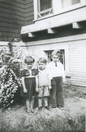
- Photograph of siblings Lance, Robert and Gladys Woodean, children of Pearl and Ed Woodean, taken on Brantford Avenue.
- Repository
- City of Burnaby Archives
- Date
- [194-] (date of original), copied 1992
- Collection/Fonds
- Burnaby Historical Society fonds
- Subseries
- Burnaby Centennial Anthology subseries
- Physical Description
- 1 photograph : b&w ; 8.7 x 12.7 cm print
- Description Level
- Item
- Record No.
- 315-015
- Access Restriction
- No restrictions
- Reproduction Restriction
- Reproduce for fair dealing purposes only
- Accession Number
- BHS1994-04
- Scope and Content
- Photograph of siblings Lance, Robert and Gladys Woodean, children of Pearl and Ed Woodean, taken on Brantford Avenue.
- Media Type
- Photograph
- Notes
- Title based on contents of photograph
- Geographic Access
- Brantford Avenue
- Historic Neighbourhood
- Edmonds (Historic Neighbourhood)
- Planning Study Area
- Kingsway-Beresford Area
Images
![Woodean family children, [194-] (date of original), copied 1992 thumbnail](/media/hpo/_Data/_Archives_Images/_Unrestricted/315/315-015.jpg)
postcard
https://search.heritageburnaby.ca/link/museumartifact44517
- Repository
- Burnaby Village Museum
- Accession Code
- BV002.34.1
- Description
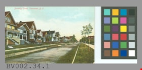
- Postcard: colour-tinted photo; horizontal; shows row of houses at left, road with wooden forms? either side, row of newly planted trees staked in grass at right, sidewalks; in red at top left, "Burnaby Street, Vancouver, B.C."; on reverse in red, "PRIVATE POST CARD"; up left side, "Published by Stedman Bros. Ltd., Brantford, Canada. Made in Germany."; line across card and line down centre; at left, "THIS SPACE MAY BE USED FOR CORRESPONDENCE", at right, "THIS SPACE IS FOR ADDRESS ONLY"; outline of rectangle at upper right, "1c. CANADA AND UNITED STATES." "2c. FOREIGN."; at lower left corner, "S B 2027"; unused; lightly soiled; wear on corners
- Object History
- Bought from E-Bay as purchase #1093584940.
- Classification
- Written Communication T&E - - Writing Media
- Object Term
- Postcard
- Maker
- Stedman Bros. Limited
- Country Made
- Canada
- Province Made
- Manitoba
- Site/City Made
- Brantford
- Title
- Burnaby Street, Vancouver, B.C. S B 2027
- Geographic Access
- Vancouver
Images

scale
https://search.heritageburnaby.ca/link/museumartifact29151
- Repository
- Burnaby Village Museum
- Accession Code
- HV973.42.1
- Description
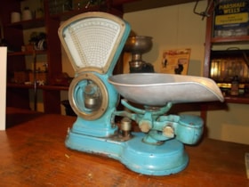
- Computing scale, "Brantford Scale Co. Ltd. Brantford Canada", with scale scoop; blue.
- Object History
- Was likely a confectioner's scale.
Images

![Land Clearing, [1913] (date of original), copied 1986 thumbnail](/media/hpo/_Data/_Archives_Images/_Unrestricted/204/204-226.jpg?width=280)
Land Clearing
https://search.heritageburnaby.ca/link/archivedescription35369
- Repository
- City of Burnaby Archives
- Date
- [1913] (date of original), copied 1986
- Collection/Fonds
- Burnaby Historical Society fonds
- Description Level
- Item
- Physical Description
- 1 photograph : b&w ; 12.7 x 17.8 cm print
- Scope and Content
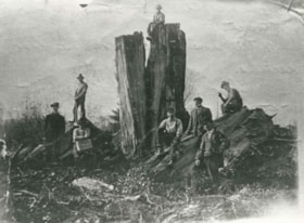
- Photograph of land clearing by a crew contracted by the municipality to clear the area between Colborne Avenue, Brantford Avenue and Imperial Street in South Burnaby. William Walker was a member of this crew. The land was cleared by blasting.
- Repository
- City of Burnaby Archives
- Date
- [1913] (date of original), copied 1986
- Collection/Fonds
- Burnaby Historical Society fonds
- Subseries
- Pioneer Tales subseries
- Physical Description
- 1 photograph : b&w ; 12.7 x 17.8 cm print
- Description Level
- Item
- Record No.
- 204-226
- Access Restriction
- No restrictions
- Reproduction Restriction
- No known restrictions
- Accession Number
- BHS1988-03
- Scope and Content
- Photograph of land clearing by a crew contracted by the municipality to clear the area between Colborne Avenue, Brantford Avenue and Imperial Street in South Burnaby. William Walker was a member of this crew. The land was cleared by blasting.
- Subjects
- Land Clearing
- Media Type
- Photograph
- Notes
- Title based on contents of photograph
- Historic Neighbourhood
- Edmonds (Historic Neighbourhood)
- Planning Study Area
- Kingsway-Beresford Area
Images
![Land Clearing, [1913] (date of original), copied 1986 thumbnail](/media/hpo/_Data/_Archives_Images/_Unrestricted/204/204-226.jpg)
![Survey and Subdivision plans in New Westminster District Group 1 – Burnaby, Port Moody, [1862-1908] thumbnail](/media/hpo/_Data/_BVM_Cartographic_Material/1977/1977_0093_0026a_001.jpg?width=280)
Survey and Subdivision plans in New Westminster District Group 1 – Burnaby, Port Moody
https://search.heritageburnaby.ca/link/museumdescription6995
- Repository
- Burnaby Village Museum
- Date
- [1862-1908]
- Collection/Fonds
- Burnaby Village Museum Map collection
- Description Level
- File
- Physical Description
- 9 plans : 6 plans : black ink on paper ; 57 x 36.5 cm or smaller + 1 plan : black ink and grahite on paper ; 46.5 x 49 cm + 1 plan : blueprint on paper ; 15.5 x 19.5 cm + cm + 1 plan : graphite on paper ; 25 x 17 cm ; mounted on both sides of board 76 x 102 cm
- Scope and Content
- Item consists of a large board of four New Westminster District subdivision plans mounted on one side and five New Westminster District subdivision plans mounted on the other side. Side A: 1. "Plan / of Subdivision / of a Portion / of / Lot 87 / Group One / New Westminster District / Scale 4 chs…
- Repository
- Burnaby Village Museum
- Collection/Fonds
- Burnaby Village Museum Map collection
- Description Level
- File
- Physical Description
- 9 plans : 6 plans : black ink on paper ; 57 x 36.5 cm or smaller + 1 plan : black ink and grahite on paper ; 46.5 x 49 cm + 1 plan : blueprint on paper ; 15.5 x 19.5 cm + cm + 1 plan : graphite on paper ; 25 x 17 cm ; mounted on both sides of board 76 x 102 cm
- Material Details
- Scales [between 1:792 and 1:3600]
- Index number on edge of board reads: "26"
- Scope and Content
- Item consists of a large board of four New Westminster District subdivision plans mounted on one side and five New Westminster District subdivision plans mounted on the other side. Side A: 1. "Plan / of Subdivision / of a Portion / of / Lot 87 / Group One / New Westminster District / Scale 4 chs = 1 in". Plan is stamped: "Albert J. Hill, Civil Engineer / and / Provincial Land Surveyor, / New Westminster, / B.C." and intialed by: "RB" [sic] (in blue pencil crayon). Names two of the subdivisons of District Lot 87 are identified as, "L.E. Sprott" and "John Ledger". (Geographic location: Burnaby) 2. "Plan of Subdivision / of / Portions of / Lot 136, 131 and Lots 44 and 78 Gr.1 / New Westminster District / Scale 300 ft = 1 inch". Annotation above title reads: "No. 901 / Deposited in Land Registry Office / New Westminster / Aug. 19th 1905 / Charles S. Keith D. Reg." Annotations and signatures at bottom of plan read: "I, William Nelson Draper, / W.H.R. Collister / Charles E. Perkins / E.B. Morgan / make / Surveys / correct / representation / upon / the / Land Registry Act / (sgd) W.N. Draper, P.L.S.". Plan includes a handwritten title: "Lots 136, 131, 44 & 78" and is initialed: "RB" [sic] (in blue pencil crayon) (Geographic location: Burnaby) 3. "Survey / of / a Portion / of / Lot 95, Gr.1 / Scale 1 ch = 1in." Plan is stamped: "Albert J. Hill, Civil Engineer / and / Provincial Land Surveyor, / New Westminster, / B.C." and is initialed : "RB" [sic] (in blue pencil crayon) (Geographic location: Burnaby) 4. Blueprint plan of "Lot 396. Group One." with Scale : 3 chs = 1 in. A two acre portion of District Lot 396 is filled in with red ink." Plan is signed by "Albert J. Hill / B.C.L.S." (Geographic location: Port Moody) Side B: 1. Plan titled "District Lot 92 / Burnaby / Municipality / for sale by / Mahon / McFarland & / Mahon Ltd. / Vancouver, B.C. / Scale : 4 chains to one inch". District Lot 92 is subdivided into 161 lots and identifies roads: Norwich Road, Pole Line Road, Oakland Road, Stanley Road, Burford Road, Dalhousie Road, Brantford Road, Colborne Road, Roberts Road, Vancouver & Westminster Road, B.C. Electric Railway, Gilley Stn. and Burnaby (Power House). The bottom of the plan reads: "G.S. Dawson, P.LS. Vancouver, B.C." (Geographic location: Burnaby) 2. "Plan / of Subdivision / of a Portion / of / Lot 29 / Group 1 / New Westminster District / Scale 2 chs = 1 in". Plan is stamped: "Albert J. Hill, Civil Engineer / and / Provincial Land Surveyor, / New Westminster, / B.C." and is initialed by: "RB" [sic] (in blue pencil crayon) (Geographic location: Burnaby) 3. Small handrawn plan (no title) identifying "Lot 84 / Hydes, Claim" at the centre surrounded by lots and features identified as: "Lot 85", "Lot 93", "Lot 94", "Lot 32", "Lot 82", "Lot 83", "Lot 79", "swamp" and a "Small Lake" (Burnaby Lake). Identifying marks in the right corner of the plan read: "Page 13 / Surveyed by G. Turner / May 62". Plan also includes surveyor's bearing measurements and trails to "Small Lake" (Burnaby Lake). (Geographic location: Burnaby) 4. Untitled plan showing District Lots west of North Road and north of Burnaby Lake including: Lots 2, 4, 6, 8, 15, 10, 56, 148, 57, 58, 40. and Lots 3, 5, 7 east of North Road (Coquitlam). Lots in Burnaby are identifed for timber including: "Heavily Timbered" (Lot 57), " "Some Fir and Cedar" (Lot 40), "Splendid Fir and Cedar" (Lot 143), "Heavy Fir etc" (Lots 143 and 148), " "Fine Cedar" (Lot 15), "Rough Light Timber" (Lot 56). Other features identified at the lower portion of the plan include "Burnaby Lake" and "Brunette River". (Geographic location: Burnaby) 5. Untitled plan drawn in graphite showing sections of District Lot 85 south of Burnaby Lake and north of Hazsard Road. Plan is signed: "Albert J. Hill / B.C.L.S." and dated "12/26/08". Plan is initialed by: "RB" [sic] (in blue pencil crayon) (Geographic location: Burnaby)
- Publisher
- Mahon, McFarland & Mahon Ltd
- Accession Code
- HV977.93.26
- Access Restriction
- No restrictions
- Reproduction Restriction
- No known restrictions
- Date
- [1862-1908]
- Media Type
- Cartographic Material
- Historic Neighbourhood
- Burnaby Lake (Historic Neighbourhood)
- Burquitlam (Historic Neighbourhood)
- Planning Study Area
- Burnaby Lake Area
- Scan Resolution
- 300
- Scale
- 72
- Notes
- Title based on contents of file
- Scale is measured in chains and feet. (One chain equals 792 inches)
- The term "Lot" can also refer to a "District Lot”
Images
![Survey and Subdivision plans in New Westminster District Group 1 – Burnaby, Port Moody, [1862-1908] thumbnail](/media/hpo/_Data/_BVM_Cartographic_Material/1977/1977_0093_0026a_001.jpg)


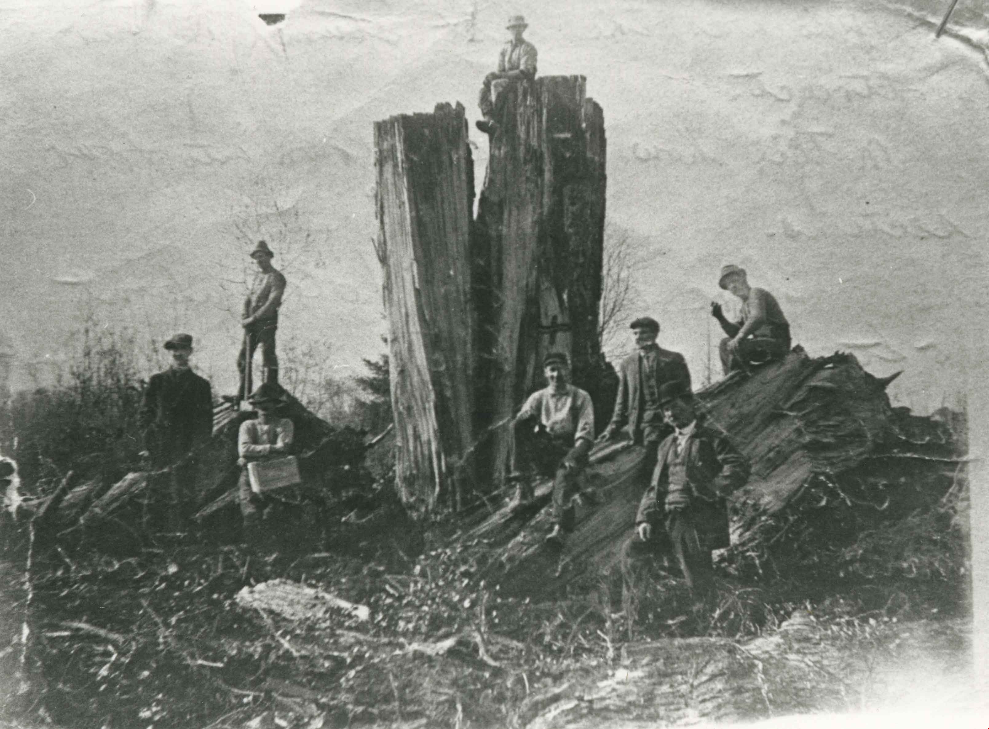
William Walker and his crew
https://search.heritageburnaby.ca/link/archivedescription35368
- Repository
- City of Burnaby Archives
- Date
- 1913 (date of original), copied 1986
- Collection/Fonds
- Burnaby Historical Society fonds
- Description Level
- Item
- Physical Description
- 1 photograph : b&w ; 12.7 x 17.8 cm print
- Scope and Content
- Photograph of William Walker, a member of a crew contracted by the municipality to clear the area between Colborne Avenue, Brantford Avenue and Imperial Street in South Burnaby The land was cleared by blasting. The tree in this picture measured 24 feet in circumference.
- Repository
- City of Burnaby Archives
- Date
- 1913 (date of original), copied 1986
- Collection/Fonds
- Burnaby Historical Society fonds
- Subseries
- Pioneer Tales subseries
- Physical Description
- 1 photograph : b&w ; 12.7 x 17.8 cm print
- Description Level
- Item
- Record No.
- 204-225
- Access Restriction
- No restrictions
- Reproduction Restriction
- No known restrictions
- Accession Number
- BHS1988-03
- Scope and Content
- Photograph of William Walker, a member of a crew contracted by the municipality to clear the area between Colborne Avenue, Brantford Avenue and Imperial Street in South Burnaby The land was cleared by blasting. The tree in this picture measured 24 feet in circumference.
- Subjects
- Land Clearing
- Plants - Trees
- Names
- Walker, William
- Media Type
- Photograph
- Notes
- Title based on contents of photograph
- Historic Neighbourhood
- Edmonds (Historic Neighbourhood)
- Planning Study Area
- Kingsway-Beresford Area
Images