Narrow Results By
Subject
- Advertising Medium - Signs and Signboards 2
- Buildings - Commercial - Grocery Stores 1
- Buildings - Commercial - Stores 1
- Buildings - Commercial - Train Stations 1
- Buildings - Industrial 3
- Buildings - Residential - Houses 1
- Clothing - Military Uniforms 1
- Geographic Features - Gardens 2
- Geographic Features - Roads 3
- Land Clearing 1
- Officials - Alderman and Councillors 1
- Officials - Mayors and Reeves 1
Person / Organization
- Brenchley, William 1
- British Columbia Electric Railway Company 1
- British Columbia Hydro and Power Authority 1
- Carpenter, Edith 1
- Carpenter, Ernie 1
- Carpenter, Ernie Jr. 1
- Haszard, Arthur de Windt 1
- Hill, Louis Claude "Claude" 1
- Jensen, Molly Carpenter 1
- McDermott, William 1
- Philip, Alex 1
- Royal Canadian Mounted Police 1
7026 Kingsway, Burnaby
https://search.heritageburnaby.ca/link/archivedescription93819
- Repository
- City of Burnaby Archives
- Date
- January 1993
- Collection/Fonds
- Grover, Elliott & Co. Ltd. fonds
- Description Level
- File
- Physical Description
- 32 photographs : col. negatives ; 35 mm
- Scope and Content
- Photographs of an undeveloped property located at 7026 Kingsway - an address that no longer exists.
- Repository
- City of Burnaby Archives
- Date
- January 1993
- Collection/Fonds
- Grover, Elliott & Co. Ltd. fonds
- Physical Description
- 32 photographs : col. negatives ; 35 mm
- Description Level
- File
- Record No.
- 622-062
- Access Restriction
- No restrictions
- Reproduction Restriction
- No restrictions
- Accession Number
- 2017-39
- Scope and Content
- Photographs of an undeveloped property located at 7026 Kingsway - an address that no longer exists.
- Subjects
- Geographic Features - Roads
- Media Type
- Photograph
- Notes
- Transcribed title
- Title transcribed from envelope photographs were originally housed in
- File no. 93-013-R
- Sticky note adhered to 622-062-4 print reads: "1 / 7026 Kingsway Burnaby, B.C."
- Sticky note adhere to 622-062-8 print reads: "3 / View west along Kingsway"
- Sticky note adhered to 622-062-12 print reads: "5 / View northwest across the site from Beresford Street"
- Sticky note adhered to 622-062-16 print reads: "4 . View [illegible] along to Beresford Ave. right of way at the southeast corner of the [illegible] site"
- Sticky note adhered to 622-062-20 print reads: "6 / View east along Beresford Street at Greenford Avenue"
- Sticky note adhered to 622-062-24 print reads: "7 / View north along Greenford Avenue"
- Sticky note adhered to 622-062-28 print reads: "8 / View northeast across the site from Grenford Avenue"
- Sticky note adhered to 622-062-32 print reads: "2 / View east along Kingsway past subject site"
- Photographer identified as "D.E."
- Geographic Access
- Kingsway
- Historic Neighbourhood
- Edmonds (Historic Neighbourhood)
- Planning Study Area
- Stride Avenue Area
7050 Buller Ave
https://search.heritageburnaby.ca/link/archivedescription93884
- Repository
- City of Burnaby Archives
- Date
- March 1993
- Collection/Fonds
- Grover, Elliott & Co. Ltd. fonds
- Description Level
- File
- Physical Description
- 25 photographs : col. negatives ; 35 mm
- Scope and Content
- Photographs of an industrial building located at 7050 Buller Avenue taken from Buller Avenue and Beresford Street.
- Repository
- City of Burnaby Archives
- Date
- March 1993
- Collection/Fonds
- Grover, Elliott & Co. Ltd. fonds
- Physical Description
- 25 photographs : col. negatives ; 35 mm
- Description Level
- File
- Record No.
- 622-067
- Access Restriction
- No restrictions
- Reproduction Restriction
- No restrictions
- Accession Number
- 2017-39
- Scope and Content
- Photographs of an industrial building located at 7050 Buller Avenue taken from Buller Avenue and Beresford Street.
- Media Type
- Photograph
- Photographer
- Young, Richard
- Notes
- Transcribed title
- Title transcribed from envelope photographs were originally housed in
- File no. 93-109-B
- Geographic Access
- Buller Avenue
- Beresford Street
- Street Address
- 7050 Buller Avenue
- Planning Study Area
- Windsor Area

Automobile on Kinnee Street
https://search.heritageburnaby.ca/link/archivedescription35060
- Repository
- City of Burnaby Archives
- Date
- 1915
- Collection/Fonds
- Burnaby Historical Society fonds
- Description Level
- Item
- Physical Description
- 1 photograph : b&w ; 11.0 x 6.2 cm
- Scope and Content
- Photograph of an automobile on Kinnee Street with the Patterson Avenue pump house and tank in the background. An annotation on the back of the photograph reads, "Water tank at Patterson Ave near the track in the Central Park (Ball park), 1915. / The roadway was Kinnee Ave which is Beresford today."
- Repository
- City of Burnaby Archives
- Date
- 1915
- Collection/Fonds
- Burnaby Historical Society fonds
- Subseries
- Pitman family subseries
- Physical Description
- 1 photograph : b&w ; 11.0 x 6.2 cm
- Description Level
- Item
- Record No.
- 186-004
- Access Restriction
- No restrictions
- Reproduction Restriction
- No known restrictions
- Accession Number
- BHS1986-35
- Scope and Content
- Photograph of an automobile on Kinnee Street with the Patterson Avenue pump house and tank in the background. An annotation on the back of the photograph reads, "Water tank at Patterson Ave near the track in the Central Park (Ball park), 1915. / The roadway was Kinnee Ave which is Beresford today."
- Media Type
- Photograph
- Notes
- Title based on contents of photograph
- Geographic Access
- Beresford Street
- Historic Neighbourhood
- Central Park (Historic Neighbourhood)
- Planning Study Area
- Maywood Area
Images


BC Hydro Railway Crossing
https://search.heritageburnaby.ca/link/archivedescription79487
- Repository
- City of Burnaby Archives
- Date
- September 22, 1976
- Collection/Fonds
- Burnaby Public Library Contemporary Visual Archive Project
- Description Level
- Item
- Physical Description
- 1 photograph : b&w ; 11 x 16 cm mounted on cardboard
- Scope and Content
- Photograph shows BC Hydro railroad tracks and crossing near Beresford Street and Griffiths Avenue.
- Repository
- City of Burnaby Archives
- Date
- September 22, 1976
- Collection/Fonds
- Burnaby Public Library Contemporary Visual Archive Project
- Physical Description
- 1 photograph : b&w ; 11 x 16 cm mounted on cardboard
- Description Level
- Item
- Record No.
- 556-319
- Access Restriction
- No restrictions
- Reproduction Restriction
- Reproduce for fair dealing purposes only
- Accession Number
- 2013-13
- Scope and Content
- Photograph shows BC Hydro railroad tracks and crossing near Beresford Street and Griffiths Avenue.
- Media Type
- Photograph
- Photographer
- Ross, Martha
- Notes
- Scope note taken directly from BPL photograph description.
- 1 b&w copy negative : 10 x 12.5 cm accompanying
- Historic Neighbourhood
- Edmonds (Historic Neighbourhood)
- Planning Study Area
- Stride Avenue Area
Images

BC Hydro Substation
https://search.heritageburnaby.ca/link/archivedescription79356
- Repository
- City of Burnaby Archives
- Date
- September 22, 1976
- Collection/Fonds
- Burnaby Public Library Contemporary Visual Archive Project
- Description Level
- Item
- Physical Description
- 1 photograph : b&w ; 11 x 16 cm mounted on cardboard
- Scope and Content
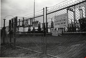
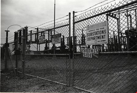
- Photograph shows a BC Hydro substation located in Powerhouse Park near Beresford Street and Griffiths Avenue.
- Repository
- City of Burnaby Archives
- Date
- September 22, 1976
- Collection/Fonds
- Burnaby Public Library Contemporary Visual Archive Project
- Physical Description
- 1 photograph : b&w ; 11 x 16 cm mounted on cardboard
- Description Level
- Item
- Record No.
- 556-263
- Access Restriction
- No restrictions
- Reproduction Restriction
- Reproduce for fair dealing purposes only
- Accession Number
- 2013-13
- Scope and Content
- Photograph shows a BC Hydro substation located in Powerhouse Park near Beresford Street and Griffiths Avenue.
- Media Type
- Photograph
- Photographer
- Ross, Martha
- Notes
- Scope note taken directly from BPL photograph description.
- 1 b&w copy negative : 10 x 12.5 cm accompanying
- Geographic Access
- Griffiths Avenue
- Beresford Street
- Street Address
- 6970 Beresford Street
- Historic Neighbourhood
- Edmonds (Historic Neighbourhood)
- Planning Study Area
- Stride Avenue Area
Images

Bond family home
https://search.heritageburnaby.ca/link/archivedescription35832
- Repository
- City of Burnaby Archives
- Date
- 1913 (date of original), copied 1986
- Collection/Fonds
- Burnaby Historical Society fonds
- Description Level
- Item
- Physical Description
- 1 photograph : b&w ; 12.7 x 17.8 cm print
- Scope and Content
- Photograph of the second Bond family home, on John Street (later renamed and renumbered 4144 Beresford Street; the site was then addressed as 6128 Patterson Avenue after the house was demolished). David Bond, the father of the family and also a carpenter, built this 14-room house in the Central Pa…
- Repository
- City of Burnaby Archives
- Date
- 1913 (date of original), copied 1986
- Collection/Fonds
- Burnaby Historical Society fonds
- Subseries
- Pioneer Tales subseries
- Physical Description
- 1 photograph : b&w ; 12.7 x 17.8 cm print
- Description Level
- Item
- Record No.
- 204-691
- Access Restriction
- No restrictions
- Reproduction Restriction
- No known restrictions
- Accession Number
- BHS1988-03
- Scope and Content
- Photograph of the second Bond family home, on John Street (later renamed and renumbered 4144 Beresford Street; the site was then addressed as 6128 Patterson Avenue after the house was demolished). David Bond, the father of the family and also a carpenter, built this 14-room house in the Central Park district.
- Subjects
- Buildings - Residential - Houses
- Media Type
- Photograph
- Notes
- Title based on contents of photograph
- Geographic Access
- Beresford Street
- Patterson Avenue
- Street Address
- 6128 Patterson Avenue
- Historic Neighbourhood
- Central Park (Historic Neighbourhood)
- Planning Study Area
- Maywood Area
Images

Burnaby Council
https://search.heritageburnaby.ca/link/archivedescription34065
- Repository
- City of Burnaby Archives
- Date
- 1892
- Collection/Fonds
- Burnaby Historical Society fonds
- Description Level
- Item
- Physical Description
- 1 photograph : sepia postcard ; 9 x 11.5 cm
- Scope and Content
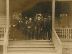
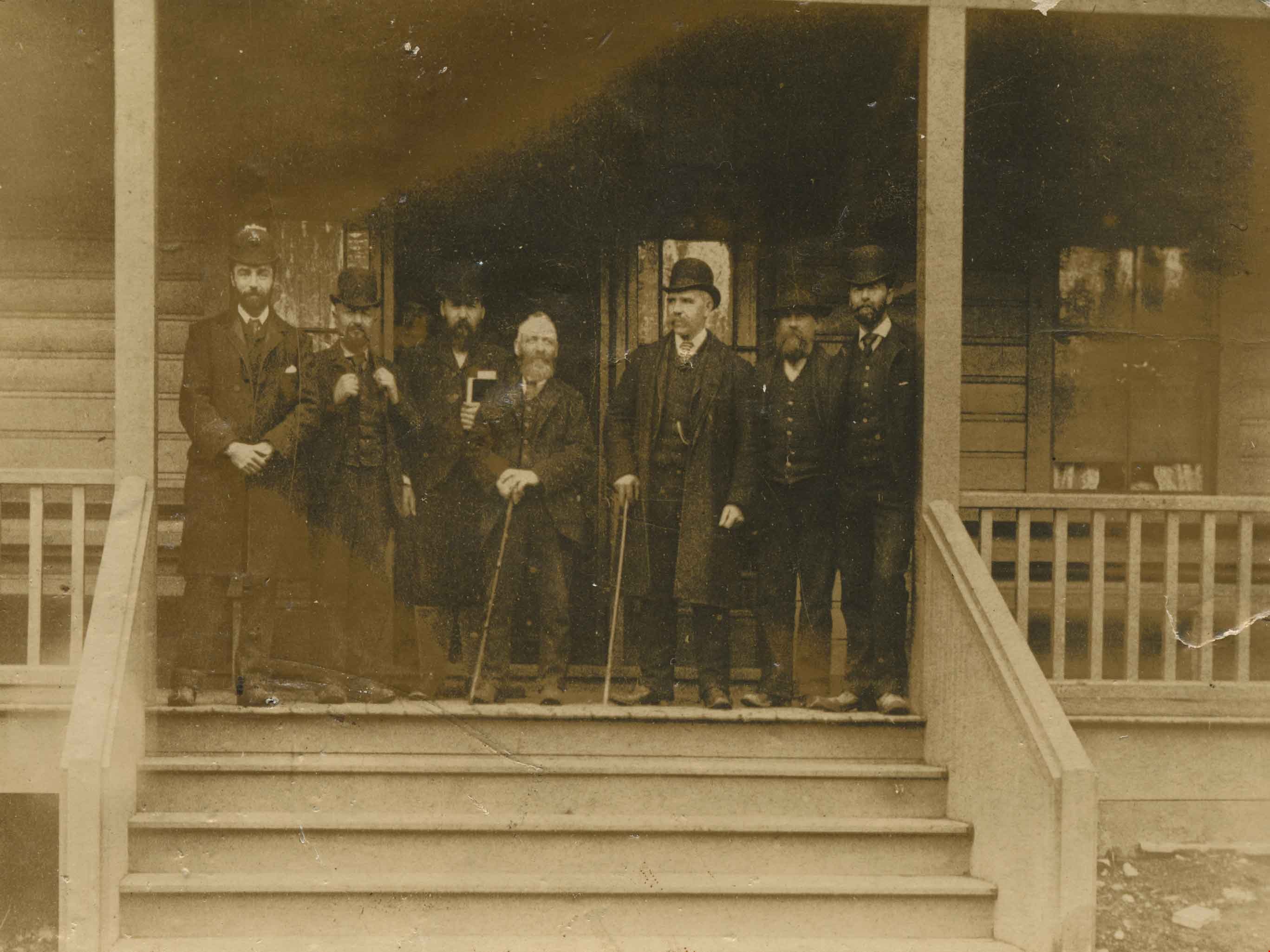
- Photograph of Burnaby's first Council members on the steps of Sample's Boarding House, 6850 Beresford Street, near Griffiths Avenue and Kingsway. Left to right: L.C. Hill, William Brenchley, Alex Philip (clerk), Charles R. Shaw (Reeve), William McDermott, John Woolard, and Arthur de Windt Haszard.
- Repository
- City of Burnaby Archives
- Date
- 1892
- Collection/Fonds
- Burnaby Historical Society fonds
- Subseries
- Photographs subseries
- Physical Description
- 1 photograph : sepia postcard ; 9 x 11.5 cm
- Description Level
- Item
- Record No.
- 008-001
- Access Restriction
- No restrictions
- Reproduction Restriction
- No known restrictions
- Accession Number
- BHS2007-04
- Scope and Content
- Photograph of Burnaby's first Council members on the steps of Sample's Boarding House, 6850 Beresford Street, near Griffiths Avenue and Kingsway. Left to right: L.C. Hill, William Brenchley, Alex Philip (clerk), Charles R. Shaw (Reeve), William McDermott, John Woolard, and Arthur de Windt Haszard.
- Names
- Brenchley, William
- Haszard, Arthur de Windt
- Hill, Louis Claude "Claude"
- McDermott, William
- Philip, Alex
- Shaw, Charles R. "Chas"
- Woolard, John
- Media Type
- Photograph
- Notes
- Title based on contents of photograph
- Geographic Access
- Beresford Street
- Street Address
- 6850 Beresford Street
- Historic Neighbourhood
- Edmonds (Historic Neighbourhood)
- Planning Study Area
- Kingsway-Beresford Area
Images
![Carpenter family garden, [192-] (date of original), copied 1986 thumbnail](/media/hpo/_Data/_Archives_Images/_Unrestricted/204/204-648.jpg?width=280)
Carpenter family garden
https://search.heritageburnaby.ca/link/archivedescription35790
- Repository
- City of Burnaby Archives
- Date
- [192-] (date of original), copied 1986
- Collection/Fonds
- Burnaby Historical Society fonds
- Description Level
- Item
- Physical Description
- 1 photograph : b&w ; 12.7 x 17.8 cm print
- Scope and Content
- Photograph of the onion patch at the Carpenter family home at 3336 Beresford Street (later renumbered 5268 Beresford Street) near Royal Oak Avenue. Mr. Carpenter raised other vegetables and won many prizes at the Pacific National Exhibition (PNE).
- Repository
- City of Burnaby Archives
- Date
- [192-] (date of original), copied 1986
- Collection/Fonds
- Burnaby Historical Society fonds
- Subseries
- Pioneer Tales subseries
- Physical Description
- 1 photograph : b&w ; 12.7 x 17.8 cm print
- Description Level
- Item
- Record No.
- 204-648
- Access Restriction
- No restrictions
- Reproduction Restriction
- No known restrictions
- Accession Number
- BHS1988-03
- Scope and Content
- Photograph of the onion patch at the Carpenter family home at 3336 Beresford Street (later renumbered 5268 Beresford Street) near Royal Oak Avenue. Mr. Carpenter raised other vegetables and won many prizes at the Pacific National Exhibition (PNE).
- Subjects
- Geographic Features - Gardens
- Media Type
- Photograph
- Notes
- Title based on contents of photograph
- Geographic Access
- Beresford Street
- Street Address
- 5268 Beresford Street
- Historic Neighbourhood
- Central Park (Historic Neighbourhood)
- Planning Study Area
- Windsor Area
Images
![Carpenter family garden, [192-] (date of original), copied 1986 thumbnail](/media/hpo/_Data/_Archives_Images/_Unrestricted/204/204-648.jpg)
![Carpenter's English Garden, [192-] (date of original), copied 1986 thumbnail](/media/hpo/_Data/_Archives_Images/_Unrestricted/204/204-646.jpg?width=280)
Carpenter's English Garden
https://search.heritageburnaby.ca/link/archivedescription35788
- Repository
- City of Burnaby Archives
- Date
- [192-] (date of original), copied 1986
- Collection/Fonds
- Burnaby Historical Society fonds
- Description Level
- Item
- Physical Description
- 1 photograph : b&w ; 12.7 x 17.8 cm print
- Scope and Content
- Photograph of Ernie Carpenter's English garden at 3336 Beresford Street (later renumbered 5268 Beresford Street) near Royal Oak Avenue. He later built a second garden after the family moved into a house on Neville Street, South Burnaby.
- Repository
- City of Burnaby Archives
- Date
- [192-] (date of original), copied 1986
- Collection/Fonds
- Burnaby Historical Society fonds
- Subseries
- Pioneer Tales subseries
- Physical Description
- 1 photograph : b&w ; 12.7 x 17.8 cm print
- Description Level
- Item
- Record No.
- 204-646
- Access Restriction
- No restrictions
- Reproduction Restriction
- No known restrictions
- Accession Number
- BHS1988-03
- Scope and Content
- Photograph of Ernie Carpenter's English garden at 3336 Beresford Street (later renumbered 5268 Beresford Street) near Royal Oak Avenue. He later built a second garden after the family moved into a house on Neville Street, South Burnaby.
- Subjects
- Geographic Features - Gardens
- Media Type
- Photograph
- Notes
- Title based on contents of photograph
- Geographic Access
- Beresford Street
- Street Address
- 5268 Beresford Street
- Historic Neighbourhood
- Central Park (Historic Neighbourhood)
- Planning Study Area
- Windsor Area
Images
![Carpenter's English Garden, [192-] (date of original), copied 1986 thumbnail](/media/hpo/_Data/_Archives_Images/_Unrestricted/204/204-646.jpg)

Ernie Carpenter clearing land
https://search.heritageburnaby.ca/link/archivedescription35789
- Repository
- City of Burnaby Archives
- Date
- 1923 (date of original), copied 1986
- Collection/Fonds
- Burnaby Historical Society fonds
- Description Level
- Item
- Physical Description
- 1 photograph : b&w ; 12.7 x 17.8 cm print
- Scope and Content
- Photograph of Ernie Carpenter clearing a lot at 3336 Beresford Street (later renumbered 5268 Beresford Street) near Royal Oak Avenue. Mr. Carpenter built a house here, and then cultivated an English garden and prize-winning onions and flowers.
- Repository
- City of Burnaby Archives
- Date
- 1923 (date of original), copied 1986
- Collection/Fonds
- Burnaby Historical Society fonds
- Subseries
- Pioneer Tales subseries
- Physical Description
- 1 photograph : b&w ; 12.7 x 17.8 cm print
- Description Level
- Item
- Record No.
- 204-647
- Access Restriction
- No restrictions
- Reproduction Restriction
- No known restrictions
- Accession Number
- BHS1988-03
- Scope and Content
- Photograph of Ernie Carpenter clearing a lot at 3336 Beresford Street (later renumbered 5268 Beresford Street) near Royal Oak Avenue. Mr. Carpenter built a house here, and then cultivated an English garden and prize-winning onions and flowers.
- Subjects
- Land Clearing
- Plants - Trees
- Names
- Carpenter, Ernie
- Media Type
- Photograph
- Notes
- Title based on contents of photograph
- Geographic Access
- Beresford Street
- Street Address
- 5268 Beresford Street
- Historic Neighbourhood
- Central Park (Historic Neighbourhood)
- Planning Study Area
- Windsor Area
Images


G & L Store
https://search.heritageburnaby.ca/link/archivedescription79113
- Repository
- City of Burnaby Archives
- Date
- September 20, 1976
- Collection/Fonds
- Burnaby Public Library Contemporary Visual Archive Project
- Description Level
- Item
- Physical Description
- 1 photograph : b&w ; 11 x 16 cm mounted on cardboard
- Scope and Content
- Photograph shows numerous signs on the wall of the G & L Store built around 1945 on MacPherson Avenue near Beresford Street.
- Repository
- City of Burnaby Archives
- Date
- September 20, 1976
- Collection/Fonds
- Burnaby Public Library Contemporary Visual Archive Project
- Physical Description
- 1 photograph : b&w ; 11 x 16 cm mounted on cardboard
- Description Level
- Item
- Record No.
- 556-161
- Access Restriction
- No restrictions
- Reproduction Restriction
- Reproduce for fair dealing purposes only
- Accession Number
- 2013-13
- Scope and Content
- Photograph shows numerous signs on the wall of the G & L Store built around 1945 on MacPherson Avenue near Beresford Street.
- Media Type
- Photograph
- Photographer
- McCarron, John
- Notes
- Scope note taken directly from BPL photograph description.
- 1 b&w copy negative : 10 x 12.5 cm accompanying
- Geographic Access
- MacPherson Avenue
- Beresford Street
- Planning Study Area
- Windsor Area
Images

House at Beresford Street and Griffiths Avenue
https://search.heritageburnaby.ca/link/archivedescription78981
- Repository
- City of Burnaby Archives
- Date
- September 22, 1976
- Collection/Fonds
- Burnaby Public Library Contemporary Visual Archive Project
- Description Level
- Item
- Physical Description
- 1 photograph : b&w ; 11 x 16 cm mounted on cardboard
- Scope and Content
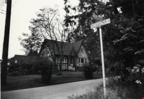
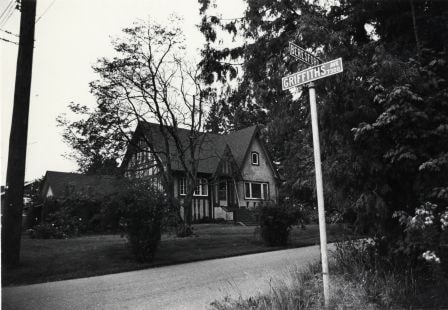
- Photograph shows a house, built in 1930, on Beresford Street at the corner of Griffiths Avenue.
- Repository
- City of Burnaby Archives
- Date
- September 22, 1976
- Collection/Fonds
- Burnaby Public Library Contemporary Visual Archive Project
- Physical Description
- 1 photograph : b&w ; 11 x 16 cm mounted on cardboard
- Description Level
- Item
- Record No.
- 556-066
- Access Restriction
- No restrictions
- Reproduction Restriction
- Reproduce for fair dealing purposes only
- Accession Number
- 2013-13
- Scope and Content
- Photograph shows a house, built in 1930, on Beresford Street at the corner of Griffiths Avenue.
- Media Type
- Photograph
- Photographer
- Ross, Martha
- Notes
- Scope note taken directly from BPL photograph description.
- 1 b&w copy negative : 10 x 12.5 cm accompanying
- Geographic Access
- Griffiths Avenue
- Beresford Street
- Historic Neighbourhood
- Edmonds (Historic Neighbourhood)
- Planning Study Area
- Stride Avenue Area
Images
Mrs. W.H. Hoyt
https://search.heritageburnaby.ca/link/archivedescription35065
- Repository
- City of Burnaby Archives
- Date
- 1917
- Collection/Fonds
- Burnaby Historical Society fonds
- Description Level
- Item
- Physical Description
- 1 photograph : b&w ; 6.5 x 10.7 cm
- Scope and Content
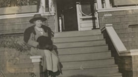
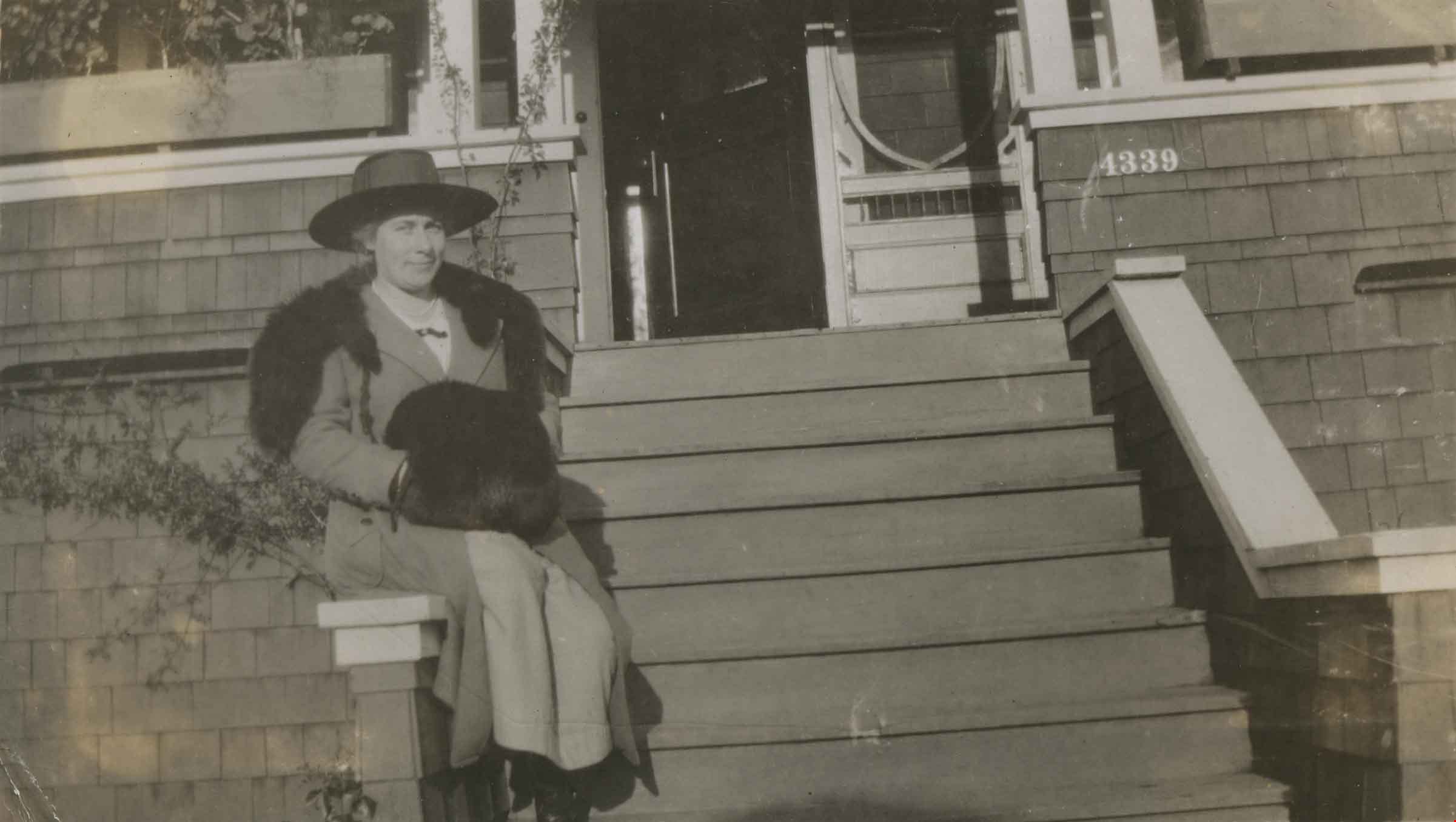
- Photograph of Mrs. W.H. Hoyt, seated outside 4339 Kinnee Avenue (later renumbered and renamed 4147 Beresford Street). An annotation on the back of the photograph reads, "Mrs. W.H. Hoyt 1917 / 4339 Kinnee Ave, Burnaby B.C. / Her one and only home for 53 years. Feb 17th to Dec 24th 1970."
- Repository
- City of Burnaby Archives
- Date
- 1917
- Collection/Fonds
- Burnaby Historical Society fonds
- Subseries
- Pitman family subseries
- Physical Description
- 1 photograph : b&w ; 6.5 x 10.7 cm
- Description Level
- Item
- Record No.
- 186-009
- Access Restriction
- No restrictions
- Reproduction Restriction
- No known restrictions
- Accession Number
- BHS1986-35
- Scope and Content
- Photograph of Mrs. W.H. Hoyt, seated outside 4339 Kinnee Avenue (later renumbered and renamed 4147 Beresford Street). An annotation on the back of the photograph reads, "Mrs. W.H. Hoyt 1917 / 4339 Kinnee Ave, Burnaby B.C. / Her one and only home for 53 years. Feb 17th to Dec 24th 1970."
- Media Type
- Photograph
- Notes
- Title based on contents of photograph
- Geographic Access
- Beresford Street
- Street Address
- 4147 Beresford Street
- Historic Neighbourhood
- Central Park (Historic Neighbourhood)
- Planning Study Area
- Maywood Area
Images
Police Officers
https://search.heritageburnaby.ca/link/archivedescription80975
- Repository
- City of Burnaby Archives
- Date
- April 5, 1998
- Collection/Fonds
- Burnaby NewsLeader photograph collection
- Description Level
- Item
- Physical Description
- 1 photograph : b&w ; 14.5 x 21 cm
- Scope and Content
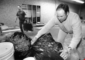
- Photograph of two Burnaby Royal Canadian Mounted Police officers removing bags of marijuana plants from a Beresford Street warehouse.
- Repository
- City of Burnaby Archives
- Date
- April 5, 1998
- Collection/Fonds
- Burnaby NewsLeader photograph collection
- Physical Description
- 1 photograph : b&w ; 14.5 x 21 cm
- Description Level
- Item
- Record No.
- 535-1160
- Access Restriction
- No restrictions
- Reproduction Restriction
- No reproduction permitted
- Accession Number
- 2012-11
- Scope and Content
- Photograph of two Burnaby Royal Canadian Mounted Police officers removing bags of marijuana plants from a Beresford Street warehouse.
- Subjects
- Public Services - Policing
- Media Type
- Photograph
- Photographer
- Bartel, Mario
- Notes
- Title based on contents of photograph
- Note in black and blue ink on recto of photograph reads: "Bby 1 80% / Bartel Bby 718 A"
- Trim marks and/or reproduction instructions on recto (scan is cropped)
- Accompanying caption reads: "April 5, 1998 718A: / Burnaby RCMP remove dozens of bags of maturing marijuana plants from Beresford Street warehouse late Thursday night. Police also seized 90 grow lamps, equipment, and a large quantity of cash. Article entitled "$2.5 million pot bust.""
Images

![Thould's dinky store, [1930] (date of original), copied 1986 thumbnail](/media/hpo/_Data/_Archives_Images/_Unrestricted/204/204-006.jpg?width=280)
Thould's dinky store
https://search.heritageburnaby.ca/link/archivedescription35149
- Repository
- City of Burnaby Archives
- Date
- [1930] (date of original), copied 1986
- Collection/Fonds
- Burnaby Historical Society fonds
- Description Level
- Item
- Physical Description
- 1 photograph : b&w ; 12.7 x 17.8 cm print
- Scope and Content
- Photograph of Grace (nee Dommet) and Lionel "Judge" Thould's "dinky" store at Highland Park Interurban station on the Central Park Interurban line.
- Repository
- City of Burnaby Archives
- Date
- [1930] (date of original), copied 1986
- Collection/Fonds
- Burnaby Historical Society fonds
- Subseries
- Pioneer Tales subseries
- Physical Description
- 1 photograph : b&w ; 12.7 x 17.8 cm print
- Description Level
- Item
- Record No.
- 204-006
- Access Restriction
- No restrictions
- Reproduction Restriction
- No known restrictions
- Accession Number
- BHS1988-03
- Scope and Content
- Photograph of Grace (nee Dommet) and Lionel "Judge" Thould's "dinky" store at Highland Park Interurban station on the Central Park Interurban line.
- Subjects
- Buildings - Commercial - Stores
- Buildings - Commercial - Train Stations
- Transportation - Electric Railroads
- Media Type
- Photograph
- Notes
- Title based on contents of photograph
- Geographic Access
- Buller Avenue
- Central Park Interurban line
- Beresford Street
- Planning Study Area
- Windsor Area
Images
![Thould's dinky store, [1930] (date of original), copied 1986 thumbnail](/media/hpo/_Data/_Archives_Images/_Unrestricted/204/204-006.jpg)
Vacant Building
https://search.heritageburnaby.ca/link/archivedescription79738
- Repository
- City of Burnaby Archives
- Date
- September 22, 1976
- Collection/Fonds
- Burnaby Public Library Contemporary Visual Archive Project
- Description Level
- Item
- Physical Description
- 1 photograph : b&w ; 11 x 16 cm mounted on cardboard
- Scope and Content
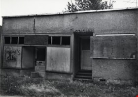
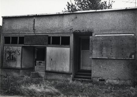
- Photograph shows a vacant building onced used as a boys club, located on Patterson Avenue between Beresford Street and Wilson Avenue.
- Repository
- City of Burnaby Archives
- Date
- September 22, 1976
- Collection/Fonds
- Burnaby Public Library Contemporary Visual Archive Project
- Physical Description
- 1 photograph : b&w ; 11 x 16 cm mounted on cardboard
- Description Level
- Item
- Record No.
- 556-410
- Access Restriction
- No restrictions
- Reproduction Restriction
- Reproduce for fair dealing purposes only
- Accession Number
- 2013-13
- Scope and Content
- Photograph shows a vacant building onced used as a boys club, located on Patterson Avenue between Beresford Street and Wilson Avenue.
- Media Type
- Photograph
- Photographer
- McCarron, John
- Notes
- Scope note taken directly from BPL photograph description.
- 1 b&w copy negative : 10 x 12.5 cm accompanying
- Geographic Access
- Patterson Avenue
Images
![Weiser Lock Co., [1958] thumbnail](/media/hpo/_Data/_Archives_Images/_Unrestricted/001/096-001.jpg?width=280)
Weiser Lock Co.
https://search.heritageburnaby.ca/link/archivedescription34687
- Repository
- City of Burnaby Archives
- Date
- [1958]
- Collection/Fonds
- Burnaby Historical Society fonds
- Description Level
- Item
- Physical Description
- 1 photograph : b&w ; 20.3 x 25.3 cm
- Scope and Content
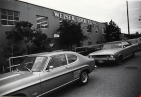
- Photograph of the exterior of Weiser Lock Co. of Canada Ltd. at 1895 Hawthorne Terrace (later renumbered 7373 Hawthorne Terrace, then 6700 Beresford Street).
- Repository
- City of Burnaby Archives
- Date
- [1958]
- Collection/Fonds
- Burnaby Historical Society fonds
- Subseries
- Photographs subseries
- Physical Description
- 1 photograph : b&w ; 20.3 x 25.3 cm
- Description Level
- Item
- Record No.
- 096-001
- Access Restriction
- No restrictions
- Reproduction Restriction
- Reproduce for fair dealing purposes only
- Accession Number
- BHS2007-04
- Scope and Content
- Photograph of the exterior of Weiser Lock Co. of Canada Ltd. at 1895 Hawthorne Terrace (later renumbered 7373 Hawthorne Terrace, then 6700 Beresford Street).
- Subjects
- Buildings - Industrial
- Media Type
- Photograph
- Photographer
- Williams Brothers Photographers Limited
- Notes
- Title based on contents of photograph
- Stamp and annotation on the back of photograph reads, "Williams Bros. Photographers Ltd. / 413 Granville St., Vancouver 2, B.C. / Phone Tatlow 8588 / 07004-1"
- Geographic Access
- Hawthorne Terrace
- Beresford Street
- Street Address
- 7373 Hawthorne Terrace
- 6700 Beresford Street
- Historic Neighbourhood
- Edmonds (Historic Neighbourhood)
- Planning Study Area
- Kingsway-Beresford Area
Images
![Weiser Lock Co., [1958] thumbnail](/media/hpo/_Data/_Archives_Images/_Unrestricted/001/096-001.jpg)
Weiser Lock Company
https://search.heritageburnaby.ca/link/archivedescription79359
- Repository
- City of Burnaby Archives
- Date
- September 22, 1976
- Collection/Fonds
- Burnaby Public Library Contemporary Visual Archive Project
- Description Level
- Item
- Physical Description
- 1 photograph : b&w ; 11 x 16 cm mounted on cardboard
- Scope and Content
- Photograph shows Weiser Lock Company Ltd. which was started in Vancouver in 1954. The plant pictured in the photograph, at 6700 Beresford Street, was constructed in 1954. The building expanded 12 times between 1954 and the time of the photograph in 1976, from the original 10,000 to 350,000 square…
- Repository
- City of Burnaby Archives
- Date
- September 22, 1976
- Collection/Fonds
- Burnaby Public Library Contemporary Visual Archive Project
- Physical Description
- 1 photograph : b&w ; 11 x 16 cm mounted on cardboard
- Description Level
- Item
- Record No.
- 556-266
- Access Restriction
- No restrictions
- Reproduction Restriction
- Reproduce for fair dealing purposes only
- Accession Number
- 2013-13
- Scope and Content
- Photograph shows Weiser Lock Company Ltd. which was started in Vancouver in 1954. The plant pictured in the photograph, at 6700 Beresford Street, was constructed in 1954. The building expanded 12 times between 1954 and the time of the photograph in 1976, from the original 10,000 to 350,000 square feet and was the only Weiser Lock plant in Canada.
- Subjects
- Buildings - Industrial
- Media Type
- Photograph
- Photographer
- Ross, Martha
- Notes
- Scope note taken directly from BPL photograph description.
- 1 b&w copy negative : 10 x 12.5 cm accompanying
- Geographic Access
- Beresford Street
- Street Address
- 6700 Beresford Street
- Historic Neighbourhood
- Edmonds (Historic Neighbourhood)
- Planning Study Area
- Kingsway-Beresford Area
Images

![What A Ride We Had, [1944] thumbnail](/media/hpo/_Data/_Archives_Images/_Unrestricted/494/494-002.JPG?width=280)
What A Ride We Had
https://search.heritageburnaby.ca/link/archivedescription58374
- Repository
- City of Burnaby Archives
- Date
- [1944]
- Collection/Fonds
- Steve Jensen fonds
- Description Level
- Item
- Physical Description
- 1 photograph (jpeg) : b&w
- Scope and Content
- Photograph shows nine people posing on or near a car. The photograph was taken facing north off Beresford Street, half a block east of Royal Oak Avenue. Identified in the photograph are Molly Jensen (nee Carpenter) who is sitting in the back seat wearing glasses; Ernie Carpenter Jr. in the driver's…
- Repository
- City of Burnaby Archives
- Date
- [1944]
- Collection/Fonds
- Steve Jensen fonds
- Physical Description
- 1 photograph (jpeg) : b&w
- Description Level
- Item
- Record No.
- 494-002
- Access Restriction
- No restrictions
- Reproduction Restriction
- Reproduce for fair dealing purposes only
- Accession Number
- 2009-03
- Scope and Content
- Photograph shows nine people posing on or near a car. The photograph was taken facing north off Beresford Street, half a block east of Royal Oak Avenue. Identified in the photograph are Molly Jensen (nee Carpenter) who is sitting in the back seat wearing glasses; Ernie Carpenter Jr. in the driver's seat; and their mother Edith Carpenter sitting on the bonnet with her hand on the windshield. The rest are unidentified.
- Media Type
- Photograph
- Photographer
- Jensen, Steve
- Notes
- Title based on contents of photograph
- Geographic Access
- Royal Oak Avenue
- Beresford Street
- Historic Neighbourhood
- Alta-Vista (Historic Neighbourhood)
- Planning Study Area
- Clinton-Glenwood Area
Images
![What A Ride We Had, [1944] thumbnail](/media/hpo/_Data/_Archives_Images/_Unrestricted/494/494-002.JPG)