Narrow Results By
Creator
- Aitkenhead, May 1
- Bartel, Mario 36
- Brandson, Lloyd S. 1
- Burnett & McGugan, Engineers and Surveyors 1
- Chapman, Fred 1
- Galbraith, Eleanor Lois 1
- Garden, Hermon and Burwell 1
- Garden, Hermon & Burwell 1
- Gauvreau, Narcisse B. 1
- Government of Canada - Department of Mines - Geological Survey Branch 1
- Hill, Albert James 3
- Knudson, Art 1
Person / Organization
- Alpha Secondary School 4
- BC Society of Model Engineers (BCSME) 3
- Begin, Gary 1
- Bill Copeland Sports Centre 1
- Boy Scouts of Canada 4
- Burnaby Central Secondary School 2
- Burnaby Clef Society 1
- Burnaby Fire Department 1
- Burnaby General Hospital 1
- Burnaby Historical Society 2
- Burnaby Village Museum 2
- Burnaby Winter Club 1
![Subdivision plans in New Westminster District Group 1 – Burnaby
, [1890-1910] thumbnail](/media/hpo/_Data/_BVM_Cartographic_Material/1977/1977_0093_0014a_001.jpg?width=280)
Subdivision plans in New Westminster District Group 1 – Burnaby
https://search.heritageburnaby.ca/link/museumdescription6983
- Repository
- Burnaby Village Museum
- Date
- [1890-1910]
- Collection/Fonds
- Burnaby Village Museum Map collection
- Description Level
- File
- Physical Description
- 4 plans : blueprint ink on paper mounted on 2 sides of cardboard 76 x 102 cm
- Scope and Content
- Item consists of a large board of two New Westminster District Gp 1 - subdivision plans mounted on one side and two New Westminster District Gp 1 - subdivision plans mounted on the other side. Side A: 1. Blueprint "Plan of / Subdivision of Lot No. 69 / Group One / New Westminster District / Pro…
- Repository
- Burnaby Village Museum
- Collection/Fonds
- Burnaby Village Museum Map collection
- Description Level
- File
- Physical Description
- 4 plans : blueprint ink on paper mounted on 2 sides of cardboard 76 x 102 cm
- Material Details
- Scales [between 1:1584 and 1:3168]
- Index number on edge of board reads: "14"
- Scope and Content
- Item consists of a large board of two New Westminster District Gp 1 - subdivision plans mounted on one side and two New Westminster District Gp 1 - subdivision plans mounted on the other side. Side A: 1. Blueprint "Plan of / Subdivision of Lot No. 69 / Group One / New Westminster District / Property of Ernest Buse, Esq. / Scale 3 chs = 1 in. / Map No 290". Plan is signed by "Garden, Hermon and Burwell, Dom. Land Surveyor" (Geographic location: Burnaby) 2. Blueprint "Plan / of Subdivision / of Lots 1-19, 36-53 and 69-75 inclusive / in the Subdivision / of / Lot 30 / Group One / New Westminster District / Scale 2 chs = 1 in. Map No 631". Plan is signed by "Jno [sic] Strathern [sic] P.L.S." Names and Lot numbers are handwritten in red pencil in sections along Douglas Road and read: "20 - F / 21 - Fitherstruhaul [sic] / 22 - J.S. Craig / 23 - McGill & Dill / 24 / 25 / 26 / 27 / 28 - School / 29 - School / 30 - D. McDownall / 31 - W.J. Troloow [sic] / 32 - N.C. Nelson / 33 - _[sic] McGill / 34 - T.S.[sic] Craig / 35" (Geographic location: Burnaby) Side B: 1.Blueprint "Plan / of Subdivision / of Centre Portion / of Lot 28 / Group One / New Westminster District / Scale 200' = 1" / Map No 627". Plan is signed by "Jno Strathern / P.L.S." (Geographic location: Burnaby) 2. Blueprint "Plan / of Subdivision / of N.1/2 Lot 100 and S.1/2 Lot 101, / Group One / New Westminster District, BC / Scale 4 chs = 1 in." (Geographic location: Burnaby)
- Names
- Strathern, John
- Accession Code
- HV977.93.14
- Access Restriction
- No restrictions
- Reproduction Restriction
- No known restrictions
- Date
- [1890-1910]
- Media Type
- Cartographic Material
- Historic Neighbourhood
- Broadview (Historic Neighbourhood)
- East Burnaby (Historic Neighbourhood)
- Planning Study Area
- Cascade-Schou Area
- West Central Valley Area
- Second Street Area
- Lake City Area
- Scan Resolution
- 300
- Scale
- 72
- Notes
- Title based on contents of file
- Scale is measured in chains and feet. (One chain equals 792 inches)
- The term "Lot" can also refer to a "District Lot”
Images
![Subdivision plans in New Westminster District Group 1 – Burnaby
, [1890-1910] thumbnail](/media/hpo/_Data/_BVM_Cartographic_Material/1977/1977_0093_0014a_001.jpg)


Subdivision plans in New Westminster District Group 1 – Burnaby, Vancouver and map - Canada Department of Mines
https://search.heritageburnaby.ca/link/museumdescription6994
- Repository
- Burnaby Village Museum
- Date
- 1890-1909
- Collection/Fonds
- Burnaby Village Museum Map collection
- Description Level
- File
- Physical Description
- 1 plan : graphite on paper + 2 plans : black ink on paper + 1 map : col. on paper mounted on 2 sides of cardboard 76 x 102 cm
- Scope and Content
- Item consists of a large board with one New Westminster District subdivision plan mounted on one side and two New Westminster District subdivision plans and one colour map mounted on the other side. Side A: 1. "Plan / of Subdivision of / Blocks 2, 3, 4, 5, 6 / Lot 77 / Group 1 / New Westminster D…
- Repository
- Burnaby Village Museum
- Collection/Fonds
- Burnaby Village Museum Map collection
- Description Level
- File
- Physical Description
- 1 plan : graphite on paper + 2 plans : black ink on paper + 1 map : col. on paper mounted on 2 sides of cardboard 76 x 102 cm
- Material Details
- Scales 1:720 and 1:1200 and 1:.00001578
- Scope and Content
- Item consists of a large board with one New Westminster District subdivision plan mounted on one side and two New Westminster District subdivision plans and one colour map mounted on the other side. Side A: 1. "Plan / of Subdivision of / Blocks 2, 3, 4, 5, 6 / Lot 77 / Group 1 / New Westminster District / BC. / Scale 100 feet = 1 inch", "Deposited 8th day / of April 1890 / Mowileg [sic] / Dist. Regt". Plan is drawn in graphite with annotations: "AB_Parts_lettered_are_lots_in / the_different_subdivisions" / "Owners: / James E. Hall / P.S.Cabilan [sic] by his attorney Joseph Hall / Joseph Hall / Eliza J. Shannon / John Harrison"; "This plan is correct and is prepared under the / provisions of the Land Registry Act" ; signed by: "Gordon Herman & Burwell / Dominion & Provincial Land Surveryors / Vancouver March 19th/90" . Plan is initialed by: "RB" [sic] (in blue pencil crayon) and measures: 99.5 x 65 cm (Geographic location: Burnaby) Side B: 1. Map titled "Canada / Department of Mines / Geological Survey Branch" / "Hon.W Templeton, Minister / A.P. Low, Deputy Minister / R.W. Brock, Acting Director", Vol. XXXI, Plate I / Compiled under the direction of / James White, F.R.G.S. Geographer /Dep. of Interior". Note above map reads: "To illustrate Mr. James Barrowman's report as Delegate at the Excursion - meeting of the Canadian Mining Institute", "The instiitution of Mining Engineers / Transactions 1908 - 1909", "The Mining Institute of Scotland / Transactions 1908-1909". Map identifies minerals and includes a Legend and Scale: 100 miles = 1 inch 2. "Plan / of Subdivision of / Lot 4 / of Subdivision of / Lot 87. Gr. 1 / New Westminster District / Scale 60' = 1in." Plan is initialed by: "RB" [sic] along with a note "also Board / 48" (in blue pencil crayon) (Geographic location: Burnaby) 3. Plan of "Lot 335 / G. 1" west of Boundary Road and north of River Road - Vancouver. (Geographic location: Vancouver)
- Publisher
- The Mining Institute of Scotland
- Geographic Access
- Vancouver
- Accession Code
- HV977.93.25
- Access Restriction
- No restrictions
- Reproduction Restriction
- No known restrictions
- Date
- 1890-1909
- Media Type
- Cartographic Material
- Scan Resolution
- 300
- Scale
- 72
- Notes
- Title based on contents of file
- Scale is measured in feet and miles.
- The term "Lot" often refers to "District Lot"
Images


The History Guard slide presentation
https://search.heritageburnaby.ca/link/museumdescription13077
- Repository
- Burnaby Village Museum
- Date
- [1895-1979] (dates of originals), copied [198-]
- Collection/Fonds
- Century Park Museum Association fonds
- Description Level
- File
- Physical Description
- 89 photographs : col. slides ; 35 mm
- Scope and Content
- File consists of a series of eighty nine slides that were used for a Heritage Village educational presentation titled "The History Guard". The slides are copies of historic images of Burnaby that were accompanied by a narrative sound recording. In the recording, narrator "John Stable" pontificates…
- Repository
- Burnaby Village Museum
- Collection/Fonds
- Century Park Museum Association fonds
- Description Level
- File
- Physical Description
- 89 photographs : col. slides ; 35 mm
- Scope and Content
- File consists of a series of eighty nine slides that were used for a Heritage Village educational presentation titled "The History Guard". The slides are copies of historic images of Burnaby that were accompanied by a narrative sound recording. In the recording, narrator "John Stable" pontificates about his role as the guard for history at Burnaby Village and shares historical information about Burnaby, heritage buildings, the Interurban tram, roads, transporation and how Burnaby transformed over time. Images include views of Heritage Village buildings and exhibits, Ceperley house, the Gilley Brothers logging, the Interurban tram, historic maps, roads, street scenes and the BC Tel building.
- Names
- Burnaby Village Museum
- Accession Code
- BV020.5.717
- Access Restriction
- No restrictions
- Reproduction Restriction
- May be restricted by third party rights
- Date
- [1895-1979] (dates of originals), copied [198-]
- Media Type
- Photograph
- Notes
- Title based on contents of file
- For recordings of the History Guard See- BV020.5.714; BV020.5.715; BV020.5.716
- For Script of Slide presentation see - BV020.5.1840
Leonard Love
https://search.heritageburnaby.ca/link/museumdescription9861
- Repository
- Burnaby Village Museum
- Date
- 1899 (date of original)-2008
- Collection/Fonds
- Burnaby Village Museum fonds
- Description Level
- File
- Physical Description
- 2 cm of textual records
- Scope and Content
- File consists of vital statistical, biographical and historical information about Leonard Love and family. Records include copies of vital statistics, interview notes, a newspaper clipping on the BC Society of Model Engineers at BVM, correspondence from descendents of Leonard Love and their memori…
- Repository
- Burnaby Village Museum
- Collection/Fonds
- Burnaby Village Museum fonds
- Series
- Jesse Love farmhouse series
- Subseries
- Love farmhouse research files subseries
- Description Level
- File
- Physical Description
- 2 cm of textual records
- Scope and Content
- File consists of vital statistical, biographical and historical information about Leonard Love and family. Records include copies of vital statistics, interview notes, a newspaper clipping on the BC Society of Model Engineers at BVM, correspondence from descendents of Leonard Love and their memories of the Love family and time spent in the farmhouse and an obituary for Gordon Wesley Love. Leonard Love was born in 1899, married Jenny Kennedy in 1922 and is the son of Jesse Love and Martha Love (nee Leonard).
- Names
- Love, John Leonard
- Accession Code
- BV018.41.72
- Access Restriction
- Subject to FIPPA
- Reproduction Restriction
- Reproductions subject to FIPPA
- Date
- 1899 (date of original)-2008
- Media Type
- Textual Record
- Notes
- Title based on content of file
Photocopy of Albert Parker album
https://search.heritageburnaby.ca/link/museumdescription9951
- Repository
- Burnaby Village Museum
- Date
- [1900-1970] (date of originals), copied 1998
- Collection/Fonds
- Burnaby Village Museum fonds
- Description Level
- File
- Physical Description
- 1 file of textual records (photocopies)
- Scope and Content
- File consists of photocopies from a photograph album owned by Albert Parker with notes that were added by Lisa Langlet as she went through the content with Albert. Photos mostly pertain to the Parker and Hughes families as well as some photos of the Love family members and the Love farmhouse includ…
- Repository
- Burnaby Village Museum
- Collection/Fonds
- Burnaby Village Museum fonds
- Series
- Jesse Love farmhouse series
- Subseries
- Love family photographs subseries
- Description Level
- File
- Physical Description
- 1 file of textual records (photocopies)
- Scope and Content
- File consists of photocopies from a photograph album owned by Albert Parker with notes that were added by Lisa Langlet as she went through the content with Albert. Photos mostly pertain to the Parker and Hughes families as well as some photos of the Love family members and the Love farmhouse including: Sarah (nee Love) and her husband William Parker; children of Sarah and William Parker; sister Elsie (nee Parker) Hughes and family in Ontario; Late 1920-1930 exterior photos of the Love farmhouse in the winter; Annie (nee Love) and husband Flash Whiting; tennis on the grounds of the Love farmhouse; Dot/Dorothy (nee Love) Brandrith and Minnie (nee Love) McKenzie; Hughes children and grandfather William Parker at Love farmhouse; Bill Parker and his wife May in the Air Force and BC coast; Elsie and John Hughes wedding day (1942); Jesse Love; John Hughes and family at the farmhouse at Christmas; Love children and spouses; camping with Annie (nee Love) Whiting; Henry Love; Sarah (nee Love) Parker and her sister Annie (nee Love) Whiting with infants; Albert and his sister Elsie Parker; Parker family old home on Newcombe Street in Burnaby; Love family and friends camping; Postcards from England; William Parker's death notice; Jesse Love and dog; Love family and friends in car; William and Phoebe (nee Love) Feedham and their boat FeBe; tennis court with family and friends; Ester (nee Love) Stanley and Robert Love in WWI uniform.
- History
- Sarah Parker (nee Love) and William Parker lived in the Jesse Love farmhouse with their children: Albert, Bill and Elsie from 1925. Elsie married John Hughes in 1942 and they had three children; Brent, Anne and John. Sarah Parker sold the Love farmhouse to her daughter Elsie and husband John Hughes in 1966. Elsie and John Hughes had four children; John Jr., Ann, Brent and Merle. They lived in the Love farmhouse with their son Brent until 1971.
- Accession Code
- BV018.41.203
- Access Restriction
- No restrictions
- Reproduction Restriction
- May be restricted by third party rights
- Date
- [1900-1970] (date of originals), copied 1998
- Media Type
- Textual Record
- Notes
- Title based on content of file
![Survey and Subdivision plans in New Westminster District Group 1 – Burnaby, [1905-1909] thumbnail](/media/hpo/_Data/_BVM_Cartographic_Material/1977/1977_0093_0024a_001.jpg?width=280)
Survey and Subdivision plans in New Westminster District Group 1 – Burnaby
https://search.heritageburnaby.ca/link/museumdescription6993
- Repository
- Burnaby Village Museum
- Date
- [1905-1909]
- Collection/Fonds
- Burnaby Village Museum Map collection
- Description Level
- File
- Physical Description
- 11 plans : 8 plans : black ink on paper + 2 plans : graphite on paper + 1 plan : graphite and ink on paper mounted on 2 sides of cardboard 76 x 102 cm
- Scope and Content
- Item consists of a large board of seven New Westminster District subdivision plans mounted on one side and four New Westminster District subdivision plans mounted on the other side. Side A: 1. Small subdivision plan of "Lot 2, Gr.1" drawn in black ink with annotation "Now Lot 1 of Subd of Lot 2 /…
- Repository
- Burnaby Village Museum
- Collection/Fonds
- Burnaby Village Museum Map collection
- Description Level
- File
- Physical Description
- 11 plans : 8 plans : black ink on paper + 2 plans : graphite on paper + 1 plan : graphite and ink on paper mounted on 2 sides of cardboard 76 x 102 cm
- Material Details
- Scales [between 1:1200 and 1:3600]
- Index number on edge of board reads: "24"
- Scope and Content
- Item consists of a large board of seven New Westminster District subdivision plans mounted on one side and four New Westminster District subdivision plans mounted on the other side. Side A: 1. Small subdivision plan of "Lot 2, Gr.1" drawn in black ink with annotation "Now Lot 1 of Subd of Lot 2 / see Bd. 5". Plan is initialed by: "RB" [sic] (in blue pencil crayon) with "Scale 3 ch = 1 in" and signed by "Albert J. Hill / P.L.S." (in graphite). (Geographic location: Burnaby) 2. Plan of "Lot 43, G.1" north of Burnaby Lake and surrounded by Lot 59, Lot 44, Lot 42. Lot 43 identifies physical features including: " roads / beaver dam / cranberry bog / roads / large brook / cutting / spruce / cedar / vine paper and alder / cedar / light spruce". Lot 59 identifies physical features: "heavy timber / alder and cedar etc" (Geographic location: Burnaby) 3. "Plan / Shewing Subdivision of part of / Lot 156 G.1 / Burnaby / N.W.D. / BC / Scale 300 ft = 1 inch" Annotation at top of plan reads: "#1030_Deposited / in the Land Registry Office / at New Westminster BC / 24th February 1908 / C.S. Keith Dist Reg I / RB". Plan is signed by "Peter Byrne / Reeve" and "H.G. Youdall [sic] _ BCLS" (Geographic location: Burnaby) 4. "Plan / of / Subdivision of Part / Lot 25, Group 1, N.W.D. / Burnaby Municipality / Scale: 3 chains = 1 inch" (drawn in graphite). Plan is initialed by: "RB" [sic] (in blue pencil crayon) and signed by "H.N. Smith" and "1024 / Deposited 25th / Jan. 1908 / Keith" (graphite) (Geographic location: Burnaby) 5. Handrawn plan in graphite is identified as "Lots 89 & 90 Gr.1" and intialed "RB" [sic] (in blue pencil crayon) (Geographic location: Burnaby) 7. Plan of "Lot 95 Gr. 1". Plan includes a portion of District Lot 95 near the intersection of centre line of B.C.E.R. and B.C.E.Ry - Vancouver Road. Plan is stamped: "Albert J. Hill, Civil Engineer / and / Provincial Land Surveyor, / New Westminster, / B.C." and initialed by "RB" [sic] (in blue pencil crayon) (Geographic location: Burnaby) 6. "Plan of Subdivision / of Sub Lot XI, Block 11 / DL 25, Gr.1 / (Burnaby) / N.W.D. / Scale 100 feet = 1 inch". Plan is dated "May 13, 1909" and signed by "W.R. Williams / Owner _ H.M. Smith" . Plan is initialed by: "RB" [sic] (in blue pencil crayon) (Geographic location: Burnaby) Side B: 1. "Plan / of Subdivision / of / Block "F" / in the Subdivision / of / Lot 29, Group 1. / New Westminster District / Scale 2chs = 1in" . Plan is stamped: "Albert J. Hill, Civil Engineer / and / Provincial Land Surveyor, / New Westminster, / B.C.". Plan is initialed by: "RB" [sic] (in blue pencil crayon) (Geographic location: Burnaby) 2. Plan of "Portion Lot B Gr.1". Plan includes annotations in graphite reading: "See Board 52-8 & 56-53" / "Sketch / see orig. plan". Plan is stamped: "Albert J. Hill, Civil Engineer / and / Provincial Land Surveyor, / New Westminster, / B.C." and is initialed by: "RB" [sic] (in blue pencil crayon) 3. Untitled plan drawn in black ink showing the "Brunette River", the "V.W. & Y.RY" and "Gunn Road _Diversion" running through Lot 13, Lot 2 - H.Gunn, Lot 4 - A.Lewis, Lot 10 - Geo. Love and W. Leonard and Lot 40. Plan is stamped: "Albert J. Hill, Civil Engineer / and / Provincial Land Surveyor, / New Westminster, / B.C." and initialed by "RB" [sic] (in blue pencil crayon) (Geographic location: Burnaby) 4."Plan / of / a Portion of the Foreshore / of / The North Arm of the Fraser River / Fronting / A Portion of Lot 166 Gr.1 / N.W. Dist. B.C. / Scale 100' = 1 " / Soundings taken from Map of D.P.W. Surveys". Plan is initialed by: "RB" [sic] (in blue pencil crayon) and includes annotations in red ink reading: "Office Copy" / "Plotted / Dec. 9th 1908 / G.K.B." (Geographic location: Burnaby)
- Creator
- Hill, Albert James
- Smith, H. Neville
- Accession Code
- HV977.93.24
- Access Restriction
- No restrictions
- Reproduction Restriction
- No known restrictions
- Date
- [1905-1909]
- Media Type
- Cartographic Material
- Historic Neighbourhood
- Burnaby Lake (Historic Neighbourhood)
- Fraser Arm (Historic Neighbourhood)
- Planning Study Area
- Burnaby Lake Area
- Scan Resolution
- 300
- Scale
- 72
- Notes
- Title based on contents of file
- Scale is measured in chains and feet. (One chain equals 792 inches)
- The term "Lot" can also refer to a "District Lot"
Images
![Survey and Subdivision plans in New Westminster District Group 1 – Burnaby, [1905-1909] thumbnail](/media/hpo/_Data/_BVM_Cartographic_Material/1977/1977_0093_0024a_001.jpg)

![Survey and Subdivision plans in New Westminster District Group 1 - Burnaby
, [1906-1910] thumbnail](/media/hpo/_Data/_BVM_Cartographic_Material/1977/1977_0093_0001a_001.jpg?width=280)
Survey and Subdivision plans in New Westminster District Group 1 - Burnaby
https://search.heritageburnaby.ca/link/museumdescription6970
- Repository
- Burnaby Village Museum
- Date
- [1906-1910]
- Collection/Fonds
- Burnaby Village Museum Map collection
- Description Level
- File
- Physical Description
- 7 plans : blueprint ink on paper + 2 plans : black ink on paper mounted on 2 sides of cardboard 76 cm x 102 cm
- Scope and Content
- Item consists of a large board of six New Westminster District Gp 1 subdivision plans mounted on one side and three New Westminster District Gp 1 subdivision plans mounted on the other side with scales ranging from one chain equals one inch to four chains equals one inch. Side A: 1. Blueprint "Pl…
- Repository
- Burnaby Village Museum
- Collection/Fonds
- Burnaby Village Museum Map collection
- Description Level
- File
- Physical Description
- 7 plans : blueprint ink on paper + 2 plans : black ink on paper mounted on 2 sides of cardboard 76 cm x 102 cm
- Material Details
- Scales [1:792] and [1:3168]
- Index number on edge of board reads: "1"
- Scope and Content
- Item consists of a large board of six New Westminster District Gp 1 subdivision plans mounted on one side and three New Westminster District Gp 1 subdivision plans mounted on the other side with scales ranging from one chain equals one inch to four chains equals one inch. Side A: 1. Blueprint "Plan / of Subdivision / of a portion / of / Lot 13, GR.1 / New Westminster District". Plan is bordered by Cumberland Street, Tenth Ave., Cariboo Street, Armstrong Street, "See Bd.145", Map No891 (Geographic location: Burnaby) 2."Plan / of Subdivision / of a portion / of / Lot 13, GR.1 / New Westminster District". Plan is bordered by Cumberland Street, Tenth Ave., Cariboo St. and Armstrong St. Pencilled annotations on plan read: "for Subdivisions see Board 145"; "Subdivided by H. Neville Smith". (Geographic location: Burnaby) 3. Blueprint "Plan / of Subdivision / of a part / of / Lot 155 / Group 1 / New Westminster District". Plan is bordered by North Arm of Fraser, Wiggins Rd. and Lot 173. Plan created by "NB Gauvreau" (Geographic location: Burnaby) Side B: 1. Blueprint plan which reads: "Albert J. Hill / P.L.S." at top with handwritten annotation: "Lot 85". The plan is bordered by Hastings Rd. and Burnaby Lake with names on lots identified as:"Laura Troop; Jas. Anderson and A. de W. Haszard". (Geographic location: Burnaby) 2. Blueprint plan which reads: "Albert J. Hill / P.L.S" at top with handwritten annotation: "Lot 85". The plan is bordered by Hastings Rd. and Burnaby Lake with names on lots identified as:"Laura Troop; A. de W. Haszard". (Geographic location: Burnaby) 3.Plan of "Survey of Road / for / Burnaby Council". "Albert J. Hill, M.A. Civil Engineer". Plan identifies "Centre Line Lot 10 / Present Road" at the centre and is bordered by Gunn Rd. at the top and Brunette River at the bottom. (Geographic location: Burnaby) 4.Blueprint "Plan / of Subdivision / Lot 97 Group 1/ N.W.D." Plan is bordered by Lots 93, 94 and 96 and Webster Road. Vancouver and New Westminster Road crosses the upper right corner of the plan and the New Westminster Vancouver Tramway runs through from Power House Rd. to Webster Road. Lower right corner identifies "W.N. Draper, P.LotS." (Geographic location: Burnaby) 5. Blueprint "Plan / of / The Subdivision of / Portion of / Lot 85, GP.1 / New Westminster District" Plan is bordered by Lots 79 / Byrne Drive; Burnaby Lake/ Esplanade and Lot 87. Plan is identified with "Albert J. Hill / B.C.LotS. / 19/6/09" (Geographic location: Burnaby) 6. Blueprint "Plan / of Subdivision/ of / Lot 155B, Group One / New Westminster District". Plan is bordered by Lots 155A, 155C, 162 / Byrne Road, 166A / Wiggins Road with Spruce Street running through the middle and Westminster- Eburne Ry. Right of Way running diagonally. Plan is identified with "Albert J. Hill (Geographic location: Burnaby)
- Accession Code
- HV977.93.1
- Access Restriction
- No restrictions
- Reproduction Restriction
- No known restrictions
- Date
- [1906-1910]
- Media Type
- Cartographic Material
- Scan Resolution
- 300
- Scan Date
- 2019-07-16
- Scale
- 72
- Notes
- Title based on contents of file
- Stamp on plans reads: "ALBERT J. HILL M.A. / CIVIL ENGINEER / and / PROVINCIAL LAND SURVEYOR / NEW WESTMINSTER / BC"
- Scale is measured in chains. (One chain equals 792 inches)
Images
![Survey and Subdivision plans in New Westminster District Group 1 - Burnaby
, [1906-1910] thumbnail](/media/hpo/_Data/_BVM_Cartographic_Material/1977/1977_0093_0001a_001.jpg)

B.C. Electric Railway Franchise
https://search.heritageburnaby.ca/link/archivedescription383
- Repository
- City of Burnaby Archives
- Date
- 1909-1912
- Collection/Fonds
- City Council and Office of the City Clerk fonds
- Description Level
- File
- Physical Description
- Textual record
- Scope and Content
- File includes a 1912 report regarding the Corporation of the District of Burnaby vs B.C. Electric Railway in the Supreme Court of BC.
- Repository
- City of Burnaby Archives
- Date
- 1909-1912
- Collection/Fonds
- City Council and Office of the City Clerk fonds
- Physical Description
- Textual record
- Description Level
- File
- Record No.
- 2076
- Accession Number
- 2001-02
- Scope and Content
- File includes a 1912 report regarding the Corporation of the District of Burnaby vs B.C. Electric Railway in the Supreme Court of BC.
- Media Type
- Textual Record
![Survey and Subdivision plans in New Westminster District Group 1 – Burnaby
, [1910] thumbnail](/media/hpo/_Data/_BVM_Cartographic_Material/1977/1977_0093_0006a_001.jpg?width=280)
Survey and Subdivision plans in New Westminster District Group 1 – Burnaby
https://search.heritageburnaby.ca/link/museumdescription6975
- Repository
- Burnaby Village Museum
- Date
- [1910]
- Collection/Fonds
- Burnaby Village Museum Map collection
- Description Level
- File
- Physical Description
- 4 plans : blueprint ink on paper ; mounted on 2 sides of cardboard 76 cm x 102 cm
- Scope and Content
- Item consists of a large board of one New Westminster District Gp 1 -subdivision plan mounted on one side and three New Westminster District Gp 1 - subdivision plans mounted on the other side. Side A: Blueprint "Plan / of Subdivision / of Lot 159 / and Portions of 158 and 95 / Group One / New We…
- Repository
- Burnaby Village Museum
- Collection/Fonds
- Burnaby Village Museum Map collection
- Description Level
- File
- Physical Description
- 4 plans : blueprint ink on paper ; mounted on 2 sides of cardboard 76 cm x 102 cm
- Material Details
- Scales [between 1:1584 and 1:3960]
- Index number on edge of board reads: "6"
- Scope and Content
- Item consists of a large board of one New Westminster District Gp 1 -subdivision plan mounted on one side and three New Westminster District Gp 1 - subdivision plans mounted on the other side. Side A: Blueprint "Plan / of Subdivision / of Lot 159 / and Portions of 158 and 95 / Group One / New Westminster District" . Plan is bordered by Gilley Station - BC Electric Railway, DL 95 to the north and DL 162 to the south. (Geographic location: Burnaby) Side B: 1. Blueprint "Subdivision / of / Lot 91 / Group One / New Westminster District / Compiled from Seven Plans on Record" (Geographic location: Burnaby) 2. Blueprint "Plan / of Subdivision / of Lot 11 / in the Subdivision / of Lots 'C', 'D' & 'G' / Lot 96 / Group One / New Westminster District". Identifier on Map reads: "Rec'd Map 976 / Board 172" 3. (Geographic location: Burnaby) 3. Blueprint plan (no title). Identifies DL 151 - Central Park, DL 32 to DL 35, DL 149 to DL 153, DL 99 and 98, DL 82 and portions of DL 38, DL 72 and DL 81 (Geographic location: Burnaby)
- Accession Code
- HV977.93.6
- Access Restriction
- No restrictions
- Reproduction Restriction
- No known restrictions
- Date
- [1910]
- Media Type
- Cartographic Material
- Scan Resolution
- 300
- Scale
- 72
- Notes
- Title based on contents of file
- Scale is measured in chains. (One chain equals 792 inches)
- The term "Lot" can also refer to a "District Lot"
Images
![Survey and Subdivision plans in New Westminster District Group 1 – Burnaby
, [1910] thumbnail](/media/hpo/_Data/_BVM_Cartographic_Material/1977/1977_0093_0006a_001.jpg)

Letter re land surveying in Lot 106 and NE 1/4 Sec. 19 Twp 2
https://search.heritageburnaby.ca/link/museumdescription11150
- Repository
- Burnaby Village Museum
- Date
- 1910
- Collection/Fonds
- Ronald G. Scobbie collection
- Description Level
- File
- Physical Description
- 4 p. of textual records
- Scope and Content
- File consists of four handwritten letters dated between October 9, 1910 and October 27, 1910 (3 pages are handwritten copies of letters from W.N. Draper) regarding . All letters include "CORPORATION OF LAND SURVEYORS OF THE PROVINCE OF BRITISH COLUMBIA" letterhead. The first letter is addressed to …
- Repository
- Burnaby Village Museum
- Collection/Fonds
- Ronald G. Scobbie collection
- Description Level
- File
- Physical Description
- 4 p. of textual records
- Scope and Content
- File consists of four handwritten letters dated between October 9, 1910 and October 27, 1910 (3 pages are handwritten copies of letters from W.N. Draper) regarding . All letters include "CORPORATION OF LAND SURVEYORS OF THE PROVINCE OF BRITISH COLUMBIA" letterhead. The first letter is addressed to "A.J. Hill / BC Land Surveyor" from Sydney Roberts Secretary of Surveyors' Corporation and the subsequent copies originate from letters addressed to S.A. Roberts from W.N. Draper.
- Accession Code
- BV003.83.29
- Access Restriction
- No restrictions
- Reproduction Restriction
- No known restrictions
- Date
- 1910
- Media Type
- Textual Record
- Notes
- Title based on contents of file
![Burnaby Girl Guides, [1914]-1969, predominant ca. 1920 (date of original), copied 2016 thumbnail](/media/hpo/_Data/_BVM_Images/2015/2015_0035_0164_folded.jpg?width=280)
Burnaby Girl Guides
https://search.heritageburnaby.ca/link/museumdescription4592
- Repository
- Burnaby Village Museum
- Date
- [1914]-1969, predominant ca. 1920 (date of original), copied 2016
- Collection/Fonds
- Burnaby Girl Guides fonds
- Description Level
- File
- Physical Description
- 1 scrapbook (textual records + 2 digital files : (pdfs) + 102 photographs : (tiffs))
- Scope and Content
- File consists of images and selected contents from a scrapbook with 38 double sided pages containing mostly photographs with some newspaper clippings, written material and emphemera including a page of badges and ribbons which reads "Enrolment & Membership Card of / Joan Bailey 1926 / 1st Burnaby" …
- Repository
- Burnaby Village Museum
- Collection/Fonds
- Burnaby Girl Guides fonds
- Description Level
- File
- Physical Description
- 1 scrapbook (textual records + 2 digital files : (pdfs) + 102 photographs : (tiffs))
- Scope and Content
- File consists of images and selected contents from a scrapbook with 38 double sided pages containing mostly photographs with some newspaper clippings, written material and emphemera including a page of badges and ribbons which reads "Enrolment & Membership Card of / Joan Bailey 1926 / 1st Burnaby" and an embroidered alphabet of the Morse Code. The third page of the scrapbook includes a four page chronology titled "History of Guiding - Burnaby / 1913 - 1960" compiled by Mrs. Dolly Weber, Mrs. J. Heaps, Miss Eileen Periton, Mrs. J. Albertson and D. Fowler. The scrapbook also includes an original letter and post-script from Lady Olave Baden-Powell to Mrs. Fowler dated November 5, 1961; a typewritten copy of: "TSOONA" / PROVINCIAL GUIDE CAMPSITE - ROSEDALE B.C." and a three page typewritten copy of "THE CAMPFIRE / Volume 1, No. 4 _ November 1935 _ Vancouver, B.C.". Many of the events documented in photographs [between 1914 and 1969] are identified on each page and read as the following: "Burnaby Brownies - Guides & Rangers" / "Early 1920" (1 photograph); "Ambulance / Display / 1st. Co."; "Girl Guide Rally - New Westminster and / Burnaby - June 16, 1923" (5 photographs); "Girl Guide Rally - New Westminster and / Burnaby - June 16, 1923" (5 photographs); "Burnaby Guides and / Brownies / June 17, 1923" (5 photographs); "April 1923" (1 photograph); "June 1923 / 2nd Burnaby Company" (1 photograph); "Burnaby May Day / 26.5.28"(2 photographs); "Sechelt 1929_ 2nd "B" Company" (2 photographs); "Leaders and Seconds / 2nd Burnaby / Grouse Mountain" (1 photograph); "Sechelt 1929 / Commandant Mrs. Peal" (1 photograph); "2nd Company / June 1930" (1 photograph); "1932 / 2nd Company at Rally / Municipal Hall Grounds" (1 photograph) ; "First Burnaby Folk Dancing team / Winners of the E.F.D. cup 1940--41-42" (1 photograph); "1st Burnaby Company / winners of Bessborough Shield / 1942 / Captain L. Crane" (1 photograph); "May 6th 1935 / Dedication of flag at Central Park" (1 photograph); "May Day Celebration / Burnaby B.C. May 6th 1935 / Stride Studios Photos" (1 photograph); "Mrs. Don Wilks / Mrs. Georgie / Runcie / Publicity Photo re- / Brownie / Training / 1958-60" (1 photograph); "Kathleen Anderson / about 1958-60?" (1 photograph); "1957 / Burnaby Camp Site / at / Wilson Creek" (1 photograph); "Work Party (1958)" (1 photograph); "Burnaby Camp Site / Spring 1958 / Cabins & Staff Houses / Dining Shelter / Cabins" (3 photographs); "Can. Girl Guide Assoc. - Provincial Leaders Conference / April 14-15/61 Civic Centre, Prince George, BC" (1 photograph) ; "June 8th, 1958 / Opening / Ceremonies / Burnaby Site / Wilson Creek / Camp Site" (4 photographs); 2 unidentified photographs [ca.1915] of a large group of Girl Guides gathered on the Pacific National Exhibition grounds (photo credit- Leonard Frank); 1 unidentified photograph of a group of Girl Guides gathered for a group portrait [ca.1914]; "Girl Guide Camp / Granthams / Landing / July 1923" (4 photographs); 4 unidentified photographs of girl guides gathered on the ship "Lady Evelyn" [ca. 1920]; "Burnaby Girl Guides" 1918; "First Burnaby Girl Guides 1920" (2 photographs on page); "2nd Co. 1923" (1 photograph) "1st Burnaby Co." [1923] (1 photograph); "Gypsy Scene - Concert / Mar 17, 1923 / Unveiling / War / Memorial / Edmonds / 1923" (3 photographs on page); "Faith Jacobson / 1961" (2 photographs); "Eve MacLean / 1961" (1 photograph); "Beverley Simkin of Montreal and Judy Robins / of the S.R.S. Royal Oak taken on the day they / sailed from Montreal for the Ranger Camp at / "Our Chalet" in Adelboden, Switzerland, May 1962" (1 photograph) and "Religion & Life Emblem / Diane Peters 11th Bby. Co. / Rev. G.W. Luetkehodeter / 1961" (2 photographs on one page).
- Names
- Girl Guides of Canada
- Accession Code
- BV015.35.164
- Access Restriction
- No restrictions
- Reproduction Restriction
- May be restricted by third party rights
- Date
- [1914]-1969, predominant ca. 1920 (date of original), copied 2016
- Media Type
- Photograph
- Textual Record
- Historic Neighbourhood
- Edmonds (Historic Neighbourhood)
- Central Park (Historic Neighbourhood)
- Planning Study Area
- Edmonds Area
- Maywood Area
- Notes
- Transcribed title
- Digital images were created of the scrapbook prior to selective retention of original records that were removed for conservation purposes
- Some textual records that were selected for retention have been described at file level under BV015.35.164: "Tsoona" Provincial Guide Campsite - Rosedale B.C." and Burnaby Girl Guides newsletter, "The Campfire" (November 1935)
- Photographs that were retained from scrapbook have been described at item level (BV015.35.221 to BV015.35.284)
- Some textual records and ephemera that were selected for retention have been described at item level (BV015.35.320, BV015.35.321, and BV015.35.334 to BV015.35.348).
Images
![Burnaby Girl Guides, [1914]-1969, predominant ca. 1920 (date of original), copied 2016 thumbnail](/media/hpo/_Data/_BVM_Images/2015/2015_0035_0164_folded.jpg)
Documents
Hill family copy negatives
https://search.heritageburnaby.ca/link/archivedescription82701
- Repository
- City of Burnaby Archives
- Date
- March 19, 1915
- Collection/Fonds
- Hill family and Vidal family fonds
- Description Level
- File
- Physical Description
- 26 photographs (24 copy negatives : b&w - 2 copy prints : b&w)
- Scope and Content
- File consists of 24 copy negatives on transparencies and 2 copy prints of photographs of the Hill family. Photographs include family portraits, landscapes (including possibly Yellow Point), and wedding portraits.
- Repository
- City of Burnaby Archives
- Date
- March 19, 1915
- Collection/Fonds
- Hill family and Vidal family fonds
- Physical Description
- 26 photographs (24 copy negatives : b&w - 2 copy prints : b&w)
- Description Level
- File
- Record No.
- 550-254
- Access Restriction
- No restrictions
- Reproduction Restriction
- No known restrictions
- Accession Number
- 2013-03
- Scope and Content
- File consists of 24 copy negatives on transparencies and 2 copy prints of photographs of the Hill family. Photographs include family portraits, landscapes (including possibly Yellow Point), and wedding portraits.
- Media Type
- Photograph
- Notes
- Title based on contents of envelope
- Note in black pen and type on recto reads: "No 24 / Mr M G Hill / 19/3/15 / 'The Kodak House' / Bishop & Christie / All Kodak Supplies / Developing : : Printing / Enlarging a Specialty / Pictures and Picture Framing / 421 Granville Street Phone: Seymour 2085 / Vancouver, BC / Charges: 1 Developing 3-6 $15 / 6 Prints 11 $30 / $45"
Collected publications
https://search.heritageburnaby.ca/link/archivedescription58062
- Repository
- City of Burnaby Archives
- Date
- 1922-1928
- Collection/Fonds
- Burnaby Historical Society fonds
- Description Level
- File
- Physical Description
- 1 file of textual records
- Scope and Content
- File consists of publications collected by Dr Blythe Eagles. One is titled "Epistaxis" published by the Medical Society of the University of Toronto and the other is titled "Evolution and the Bible; or Is Evolution opposed to Christianity?" a Sermon by Reverened [sic] A.E. Cooke / First Congregatio…
- Repository
- City of Burnaby Archives
- Date
- 1922-1928
- Collection/Fonds
- Burnaby Historical Society fonds
- Subseries
- Eagles family subseries
- Physical Description
- 1 file of textual records
- Description Level
- File
- Record No.
- MSS055-015
- Accession Number
- BHS1991-18
- Scope and Content
- File consists of publications collected by Dr Blythe Eagles. One is titled "Epistaxis" published by the Medical Society of the University of Toronto and the other is titled "Evolution and the Bible; or Is Evolution opposed to Christianity?" a Sermon by Reverened [sic] A.E. Cooke / First Congregational Church, Vancouver BC.
- Media Type
- Textual Record
- Notes
- Title based on contents of file
Letter re survey of District Lots 9, 55, 106 & 107 Group 1, New Westminster District
https://search.heritageburnaby.ca/link/museumdescription11154
- Repository
- Burnaby Village Museum
- Date
- 1927
- Collection/Fonds
- Ronald G. Scobbie collection
- Description Level
- File
- Physical Description
- 4 p. of textual records
- Scope and Content
- File consists of two typewritten letters. A three page carbon copy from Burnett & McGugan, dated 16th April 1927 Re: "DL 9-54-106-107, Gp. 1" is addressed to "R. Newman, Esq., / Corporation of Coquitlam, / Maillardville, BC". One page letter dated September 14th, 1927, includes the letterhead of "C…
- Repository
- Burnaby Village Museum
- Collection/Fonds
- Ronald G. Scobbie collection
- Description Level
- File
- Physical Description
- 4 p. of textual records
- Scope and Content
- File consists of two typewritten letters. A three page carbon copy from Burnett & McGugan, dated 16th April 1927 Re: "DL 9-54-106-107, Gp. 1" is addressed to "R. Newman, Esq., / Corporation of Coquitlam, / Maillardville, BC". One page letter dated September 14th, 1927, includes the letterhead of "Corporation of the District of Coquitlam / Muncipal Hall / Maillardville, BC" is addressed to "Messrs. Burnett & McGugan, / Engineers..." regarding a request for a "preliminary survey of District Lots 9, 55, 106 & 107". The letter is signed by Clerk "Hobart Newman".
- Accession Code
- BV003.83.33
- Access Restriction
- No restrictions
- Reproduction Restriction
- No known restrictions
- Date
- 1927
- Media Type
- Textual Record
- Notes
- Title based on contents of file
- Note in pencil on letter dated April 16, 1927 reads: "File under & Index / {DL 9, 54, 106, 107} Group 1"
- Note in pencil on verso of letter dated September 14th, 1927 reads: "Env. 3468"
Graduation records
https://search.heritageburnaby.ca/link/archivedescription82734
- Repository
- City of Burnaby Archives
- Date
- [1930-1941]
- Collection/Fonds
- Hazel Simnett collection
- Description Level
- File
- Physical Description
- 1 folder of textual records
- Scope and Content
- File consists of two envelopes and one dictionary. One envelope is empty and is addressed to: "To Whom it May Concern" and is from: "Hugh M. Fraser High School / 2350 Kingsway / New Westminster, BC". It most likely contained the reference letter from May 12, 1941 written by the principal of Hugh M.…
- Repository
- City of Burnaby Archives
- Date
- [1930-1941]
- Collection/Fonds
- Hazel Simnett collection
- Physical Description
- 1 folder of textual records
- Description Level
- File
- Record No.
- MSS167-013
- Accession Number
- 2013-22
- Scope and Content
- File consists of two envelopes and one dictionary. One envelope is empty and is addressed to: "To Whom it May Concern" and is from: "Hugh M. Fraser High School / 2350 Kingsway / New Westminster, BC". It most likely contained the reference letter from May 12, 1941 written by the principal of Hugh M. Fraser Senior and Junior High Schools. The second envelope is addressed to "Miss Hazel Simnett / 4019 Kingsway / New Westminster, BC" from the Department of Education in Victoria, BC. It contains the reference letter as discussed previously, a University Entrance Examination certificate, a High School Graduation certificate from Burnaby South High School, a Grade Twelve Examination Junior Matriculation certificate and a purple and gold ribbon. The dictionary is a Nelson's "Highroads" English Dictionary. Inside an inscription reads: "Hazel Simnett / 4019 Kingsway / Burnaby / BSHS / Hazel Simnett / Kingsway West School".
- Subjects
- Personal Symbols - Certificates
- Names
- Simnett, Hazel
- Media Type
- Textual Record
- Notes
- Title based on contents of file
- Simnett personal papers series
- Geographic Access
- Kingsway
- Historic Neighbourhood
- Central Park (Historic Neighbourhood)
- Planning Study Area
- Garden Village Area
![Easthope photograph album, [between 1930 and 1970] thumbnail](/media/Hpo/_Data/_Archives_Images/_Unrestricted/451/451-039.jpg?width=280)
Easthope photograph album
https://search.heritageburnaby.ca/link/archivedescription97972
- Repository
- City of Burnaby Archives
- Date
- [between 1930 and 1970]
- Collection/Fonds
- Burnaby Historical Society fonds
- Description Level
- File
- Physical Description
- 40 photographs : b&w on 8 album pages : 22 cm x 30 cm
- Scope and Content
- George and Dorothy Easthope photograph album. Album includes photographs of the couple on holiday, with family and pets, and building their home at 6671 Halifax Street in Burnaby, BC.
- Repository
- City of Burnaby Archives
- Date
- [between 1930 and 1970]
- Collection/Fonds
- Burnaby Historical Society fonds
- Subseries
- Easthope family subseries
- Physical Description
- 40 photographs : b&w on 8 album pages : 22 cm x 30 cm
- Description Level
- File
- Record No.
- 451-039
- Access Restriction
- No restrictions
- Reproduction Restriction
- May be restricted by third party rights
- Accession Number
- BHS2003-06
- Scope and Content
- George and Dorothy Easthope photograph album. Album includes photographs of the couple on holiday, with family and pets, and building their home at 6671 Halifax Street in Burnaby, BC.
- Media Type
- Photograph
- Notes
- Title based on contents of album
- Album is missing several photographs. These photographs may be included in 451-001:451-038.
- Geographic Access
- Halifax Street
- Street Address
- 6671 Halifax Street
- Historic Neighbourhood
- Lochdale (Historic Neighbourhood)
- Planning Study Area
- Lochdale Area
Images
![Easthope photograph album, [between 1930 and 1970] thumbnail](/media/Hpo/_Data/_Archives_Images/_Unrestricted/451/451-039.jpg)
![Pages from May Aikenhead scrapbook, [1930-1935] thumbnail](/media/hpo/_Data/_BVM_Images/2015/2015_0035_0168_all_pages.jpg?width=280)
Pages from May Aikenhead scrapbook
https://search.heritageburnaby.ca/link/museumdescription5245
- Repository
- Burnaby Village Museum
- Date
- [1930-1935]
- Collection/Fonds
- Burnaby Girl Guides fonds
- Description Level
- File
- Physical Description
- 1 file of textual records : 1 p. + 1 illustration : col. ; graphite and watercolour + 1 digital file : col. (pdf) + 10 photographs : col. (tiffs)
- Scope and Content
- File consists of pages from a scrapbook created by May Aitkenhead. Pages include an illustration of a Girl Guide in uniform done in pencil and watercolour along with two pages (double sided) of clippings from newspapers, magazines and a programme. The illustration page includes the name "Mabel McIn…
- Repository
- Burnaby Village Museum
- Collection/Fonds
- Burnaby Girl Guides fonds
- Description Level
- File
- Physical Description
- 1 file of textual records : 1 p. + 1 illustration : col. ; graphite and watercolour + 1 digital file : col. (pdf) + 10 photographs : col. (tiffs)
- Scope and Content
- File consists of pages from a scrapbook created by May Aitkenhead. Pages include an illustration of a Girl Guide in uniform done in pencil and watercolour along with two pages (double sided) of clippings from newspapers, magazines and a programme. The illustration page includes the name "Mabel McIntyre / Cl. 16" handwritten in pencil at the top of the page along with a sticker of a wreath. The newspaper clippings page is titled "Guide News" and includes selected clippings about the 5th Burnaby Girl Guides, while two other pages include information titled "Patrol Portfolio Chart No. 9 _ Digging"; "The Aims of the Girl Guides" and "Girl Guiding" with photographic images of Mrs. Alan Morkill (Provincial Commissioner for British Columbia); Countess Bessborough (Honourary President of the Canadian Girl Guide Association); His Excellency Rt. Hon. the Earl of Bessborough (Governor General and Commander in Chief of the Dominion of Canada- Chief Scout of Canada) as well as Lady and Lord Baden Powell. The last page is clipped and pasted from a programme and/or poster "Grand Rally / Scouts / and / Guides / April 15th 1935 / Hastings Park / Vancouver BC" and includes a page of the programme.
- Creator
- Aitkenhead, May
- Names
- Girl Guides of Canada
- Accession Code
- BV015.35.168
- Access Restriction
- No restrictions
- Reproduction Restriction
- May be restricted by third party rights
- Date
- [1930-1935]
- Media Type
- Textual Record
- Graphic Material
- Notes
- Title based on contents of file
- Digital images were created of the scrapbook prior to selective retention of original records
- Selected pages were removed from original scrapbook and were retained under BV015.35.168
- Selected photographs were removed from scrapbook prior and are described at item level (BV015.35.292 to BV015.35.300)
Images
![Pages from May Aikenhead scrapbook, [1930-1935] thumbnail](/media/hpo/_Data/_BVM_Images/2015/2015_0035_0168_all_pages.jpg)
Documents
Event invitations and menus
https://search.heritageburnaby.ca/link/archivedescription66385
- Repository
- City of Burnaby Archives
- Date
- 1937-1948
- Collection/Fonds
- Grieve family fonds
- Description Level
- File
- Physical Description
- 1 file of textual records
- Scope and Content
- File consists of an invitation to attend the opening of the BC Legislature and accompanying admittance card, the menu from the Laurier Club commemoration dinner for the Honourable Ian A. Mackenzie and the luncheon menu and souvenir programme for the opening of the Pattullo Bridge.
- Repository
- City of Burnaby Archives
- Date
- 1937-1948
- Collection/Fonds
- Grieve family fonds
- Physical Description
- 1 file of textual records
- Description Level
- File
- Record No.
- MSS155-011
- Accession Number
- 2011-04
- Scope and Content
- File consists of an invitation to attend the opening of the BC Legislature and accompanying admittance card, the menu from the Laurier Club commemoration dinner for the Honourable Ian A. Mackenzie and the luncheon menu and souvenir programme for the opening of the Pattullo Bridge.
- Media Type
- Textual Record
- Notes
- Transcribed title
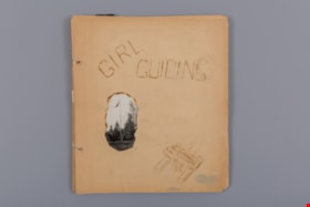
Girl Guiding
https://search.heritageburnaby.ca/link/museumdescription4588
- Repository
- Burnaby Village Museum
- Date
- 1939-1951
- Collection/Fonds
- Burnaby Girl Guides fonds
- Description Level
- File
- Physical Description
- 1 scrapbook album (99 photographs+ textual records + other material)
- Scope and Content
- File consists of 18 loose pages of a scrapbook created by Ivy McGeachie (nee Ivy Oldham) who was involved in guiding in Burnaby between 1942 -1948. The front page of the scrapbook is titled “Girl / Guiding” and has a wood-burnt image of a camp fire and a singed photo of a flag pole. The scrapbook …
- Repository
- Burnaby Village Museum
- Collection/Fonds
- Burnaby Girl Guides fonds
- Description Level
- File
- Physical Description
- 1 scrapbook album (99 photographs+ textual records + other material)
- Scope and Content
- File consists of 18 loose pages of a scrapbook created by Ivy McGeachie (nee Ivy Oldham) who was involved in guiding in Burnaby between 1942 -1948. The front page of the scrapbook is titled “Girl / Guiding” and has a wood-burnt image of a camp fire and a singed photo of a flag pole. The scrapbook contains photographs along with bits and pieces of ephemera. Included in the material is a four page, type-written diary of a Girl Guide camp held at Aldergrove Beach in August of 1963. Many of the photographs document the activities of the 2nd Burnaby Girl Guide Company and include photos of Ivy and Margaret McGeachie in uniform on roller skates; Burnaby District Camp (Aldergrove, BC) / 1948; Hiking; Canadian Girl Guide Golden Jubilee; Open House at St. Alban’s church hall; a hand tinted photo of Ivy McGeachie 1939 and the 2nd Kamloops Folk Dance – Yale Cariboo Musical festival 1951.
- Creator
- McGeachie, Ivy Ashliegh
- Accession Code
- BV015.35.160
- Access Restriction
- No restrictions
- Reproduction Restriction
- May be restricted by third party rights
- Date
- 1939-1951
- Media Type
- Photograph
- Textual Record
- Notes
- Title based on content of file
- Some photographs within scrapbook have been described at item level (BV015.35.191 to BV015.35.210)
Images

Documents
School files - Burnaby South Secondary School
https://search.heritageburnaby.ca/link/archivedescription66589
- Repository
- City of Burnaby Archives
- Date
- 1942-2007
- Collection/Fonds
- Burnaby Historical Society fonds
- Description Level
- File
- Physical Description
- 1 file of textual records
- Scope and Content
- File consists of newspaper clippings and other paper records pertaining to Burnaby South Secondary School and the BC Provincial School for the Deaf. Included in the file is a 1944 Home Economics Circular suggesting healthy recipes for school lunches as well as the September 1942 issue of the school…
- Repository
- City of Burnaby Archives
- Date
- 1942-2007
- Collection/Fonds
- Burnaby Historical Society fonds
- Subseries
- School files subseries
- Physical Description
- 1 file of textual records
- Description Level
- File
- Record No.
- 43073
- Accession Number
- BHS2007-04
- Scope and Content
- File consists of newspaper clippings and other paper records pertaining to Burnaby South Secondary School and the BC Provincial School for the Deaf. Included in the file is a 1944 Home Economics Circular suggesting healthy recipes for school lunches as well as the September 1942 issue of the school newsletter "Argus."
- Media Type
- Textual Record
- Notes
- Title based on contents of file