Narrow Results By

Streetcar
https://search.heritageburnaby.ca/link/archivedescription35443
- Repository
- City of Burnaby Archives
- Date
- 1913 (date of original), copied 1986
- Collection/Fonds
- Burnaby Historical Society fonds
- Description Level
- Item
- Physical Description
- 1 photograph : b&w ; 12.7 x 17.8 cm print
- Scope and Content
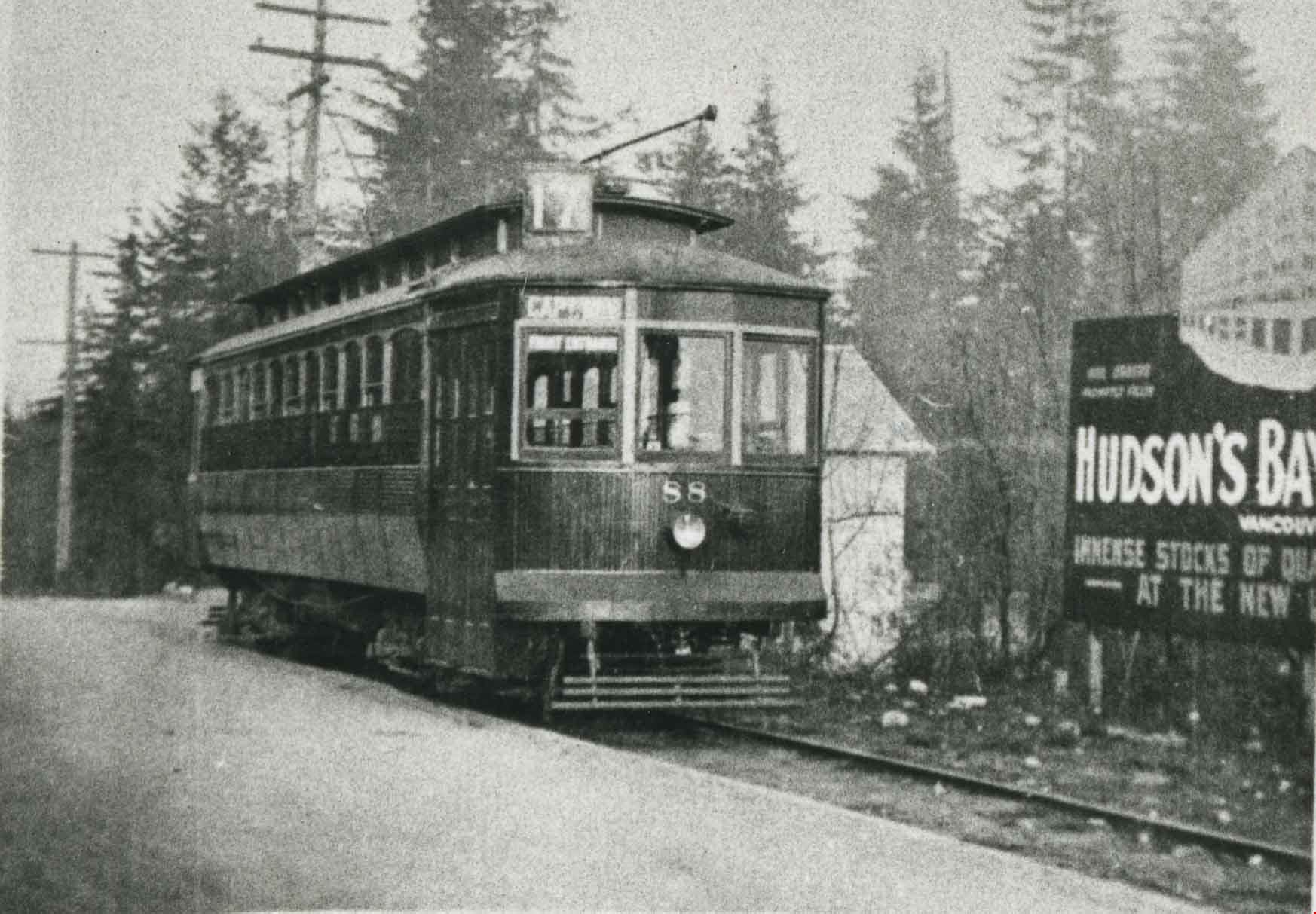
- Photograph of the extension from Boundary Road to Ellesmere Avenue on the BC Electric Railway Co. streetcar line. It operated on a single track and was inaugurated in 1913.
- Repository
- City of Burnaby Archives
- Date
- 1913 (date of original), copied 1986
- Collection/Fonds
- Burnaby Historical Society fonds
- Subseries
- Pioneer Tales subseries
- Physical Description
- 1 photograph : b&w ; 12.7 x 17.8 cm print
- Description Level
- Item
- Record No.
- 204-301
- Access Restriction
- No restrictions
- Reproduction Restriction
- No restrictions
- Accession Number
- BHS1988-03
- Scope and Content
- Photograph of the extension from Boundary Road to Ellesmere Avenue on the BC Electric Railway Co. streetcar line. It operated on a single track and was inaugurated in 1913.
- Media Type
- Photograph
- Photographer
- Eaton, Dr. Carl
- Notes
- Title based on contents of photograph
- Historic Neighbourhood
- Capitol Hill (Historic Neighbourhood)
- Planning Study Area
- Capitol Hill Area
Images
Students at Gilmore Avenue School
https://search.heritageburnaby.ca/link/museumdescription75
- Repository
- Burnaby Village Museum
- Date
- 1918
- Collection/Fonds
- Burnaby Village Museum Photograph collection
- Description Level
- Item
- Physical Description
- 1 photograph : sepia postcard ; 9 x 14 cm
- Scope and Content
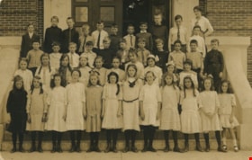
- Photograph of a class of Grade 7 students standing in four rows on the front steps of Gilmore Avenue School. The teacher, standing in the back row to the right in a polka dot blouse, is believed to be Margaret Scott. Most of the girls are in light coloured dresses with dark stockings and boots and …
- Repository
- Burnaby Village Museum
- Collection/Fonds
- Burnaby Village Museum Photograph collection
- Description Level
- Item
- Physical Description
- 1 photograph : sepia postcard ; 9 x 14 cm
- Scope and Content
- Photograph of a class of Grade 7 students standing in four rows on the front steps of Gilmore Avenue School. The teacher, standing in the back row to the right in a polka dot blouse, is believed to be Margaret Scott. Most of the girls are in light coloured dresses with dark stockings and boots and most boys are in button up shirts. Jim Warren is standing in the third row on the far left and George Pendygrasse is in the same row, ninth from the left. None of the other students have been identified.
- Subjects
- Occupations - Teachers
- Geographic Access
- Gilmore Avenue
- Street Address
- 50 Gilmore Avenue
- Accession Code
- BV989.19.4
- Access Restriction
- No restrictions
- Date
- 1918
- Media Type
- Photograph
- Historic Neighbourhood
- Vancouver Heights (Historic Neighbourhood)
- Planning Study Area
- Burnaby Heights Area
- Scan Resolution
- 600
- Scan Date
- 01-Jun-09
- Scale
- 100
- Notes
- Title based on contents of photograph
- Note written pencil on verso of postcard reads: "R. G. McManus 4275 Dundas St. North Burnaby BC. / c/o Terry-Lynn Callender"
Images
![Subdivision plans in New Westminster District Group 1 – Burnaby
, [1890-1910] thumbnail](/media/hpo/_Data/_BVM_Cartographic_Material/1977/1977_0093_0014a_001.jpg?width=280)
Subdivision plans in New Westminster District Group 1 – Burnaby
https://search.heritageburnaby.ca/link/museumdescription6983
- Repository
- Burnaby Village Museum
- Date
- [1890-1910]
- Collection/Fonds
- Burnaby Village Museum Map collection
- Description Level
- File
- Physical Description
- 4 plans : blueprint ink on paper mounted on 2 sides of cardboard 76 x 102 cm
- Scope and Content
- Item consists of a large board of two New Westminster District Gp 1 - subdivision plans mounted on one side and two New Westminster District Gp 1 - subdivision plans mounted on the other side. Side A: 1. Blueprint "Plan of / Subdivision of Lot No. 69 / Group One / New Westminster District / Pro…
- Repository
- Burnaby Village Museum
- Collection/Fonds
- Burnaby Village Museum Map collection
- Description Level
- File
- Physical Description
- 4 plans : blueprint ink on paper mounted on 2 sides of cardboard 76 x 102 cm
- Material Details
- Scales [between 1:1584 and 1:3168]
- Index number on edge of board reads: "14"
- Scope and Content
- Item consists of a large board of two New Westminster District Gp 1 - subdivision plans mounted on one side and two New Westminster District Gp 1 - subdivision plans mounted on the other side. Side A: 1. Blueprint "Plan of / Subdivision of Lot No. 69 / Group One / New Westminster District / Property of Ernest Buse, Esq. / Scale 3 chs = 1 in. / Map No 290". Plan is signed by "Garden, Hermon and Burwell, Dom. Land Surveyor" (Geographic location: Burnaby) 2. Blueprint "Plan / of Subdivision / of Lots 1-19, 36-53 and 69-75 inclusive / in the Subdivision / of / Lot 30 / Group One / New Westminster District / Scale 2 chs = 1 in. Map No 631". Plan is signed by "Jno [sic] Strathern [sic] P.L.S." Names and Lot numbers are handwritten in red pencil in sections along Douglas Road and read: "20 - F / 21 - Fitherstruhaul [sic] / 22 - J.S. Craig / 23 - McGill & Dill / 24 / 25 / 26 / 27 / 28 - School / 29 - School / 30 - D. McDownall / 31 - W.J. Troloow [sic] / 32 - N.C. Nelson / 33 - _[sic] McGill / 34 - T.S.[sic] Craig / 35" (Geographic location: Burnaby) Side B: 1.Blueprint "Plan / of Subdivision / of Centre Portion / of Lot 28 / Group One / New Westminster District / Scale 200' = 1" / Map No 627". Plan is signed by "Jno Strathern / P.L.S." (Geographic location: Burnaby) 2. Blueprint "Plan / of Subdivision / of N.1/2 Lot 100 and S.1/2 Lot 101, / Group One / New Westminster District, BC / Scale 4 chs = 1 in." (Geographic location: Burnaby)
- Names
- Strathern, John
- Accession Code
- HV977.93.14
- Access Restriction
- No restrictions
- Reproduction Restriction
- No known restrictions
- Date
- [1890-1910]
- Media Type
- Cartographic Material
- Historic Neighbourhood
- Broadview (Historic Neighbourhood)
- East Burnaby (Historic Neighbourhood)
- Planning Study Area
- Cascade-Schou Area
- West Central Valley Area
- Second Street Area
- Lake City Area
- Scan Resolution
- 300
- Scale
- 72
- Notes
- Title based on contents of file
- Scale is measured in chains and feet. (One chain equals 792 inches)
- The term "Lot" can also refer to a "District Lot”
Images
![Subdivision plans in New Westminster District Group 1 – Burnaby
, [1890-1910] thumbnail](/media/hpo/_Data/_BVM_Cartographic_Material/1977/1977_0093_0014a_001.jpg)

![Survey and Subdivision plans in New Westminster District Group 1 - Burnaby
, [1906-1910] thumbnail](/media/hpo/_Data/_BVM_Cartographic_Material/1977/1977_0093_0001a_001.jpg?width=280)
Survey and Subdivision plans in New Westminster District Group 1 - Burnaby
https://search.heritageburnaby.ca/link/museumdescription6970
- Repository
- Burnaby Village Museum
- Date
- [1906-1910]
- Collection/Fonds
- Burnaby Village Museum Map collection
- Description Level
- File
- Physical Description
- 7 plans : blueprint ink on paper + 2 plans : black ink on paper mounted on 2 sides of cardboard 76 cm x 102 cm
- Scope and Content
- Item consists of a large board of six New Westminster District Gp 1 subdivision plans mounted on one side and three New Westminster District Gp 1 subdivision plans mounted on the other side with scales ranging from one chain equals one inch to four chains equals one inch. Side A: 1. Blueprint "Pl…
- Repository
- Burnaby Village Museum
- Collection/Fonds
- Burnaby Village Museum Map collection
- Description Level
- File
- Physical Description
- 7 plans : blueprint ink on paper + 2 plans : black ink on paper mounted on 2 sides of cardboard 76 cm x 102 cm
- Material Details
- Scales [1:792] and [1:3168]
- Index number on edge of board reads: "1"
- Scope and Content
- Item consists of a large board of six New Westminster District Gp 1 subdivision plans mounted on one side and three New Westminster District Gp 1 subdivision plans mounted on the other side with scales ranging from one chain equals one inch to four chains equals one inch. Side A: 1. Blueprint "Plan / of Subdivision / of a portion / of / Lot 13, GR.1 / New Westminster District". Plan is bordered by Cumberland Street, Tenth Ave., Cariboo Street, Armstrong Street, "See Bd.145", Map No891 (Geographic location: Burnaby) 2."Plan / of Subdivision / of a portion / of / Lot 13, GR.1 / New Westminster District". Plan is bordered by Cumberland Street, Tenth Ave., Cariboo St. and Armstrong St. Pencilled annotations on plan read: "for Subdivisions see Board 145"; "Subdivided by H. Neville Smith". (Geographic location: Burnaby) 3. Blueprint "Plan / of Subdivision / of a part / of / Lot 155 / Group 1 / New Westminster District". Plan is bordered by North Arm of Fraser, Wiggins Rd. and Lot 173. Plan created by "NB Gauvreau" (Geographic location: Burnaby) Side B: 1. Blueprint plan which reads: "Albert J. Hill / P.L.S." at top with handwritten annotation: "Lot 85". The plan is bordered by Hastings Rd. and Burnaby Lake with names on lots identified as:"Laura Troop; Jas. Anderson and A. de W. Haszard". (Geographic location: Burnaby) 2. Blueprint plan which reads: "Albert J. Hill / P.L.S" at top with handwritten annotation: "Lot 85". The plan is bordered by Hastings Rd. and Burnaby Lake with names on lots identified as:"Laura Troop; A. de W. Haszard". (Geographic location: Burnaby) 3.Plan of "Survey of Road / for / Burnaby Council". "Albert J. Hill, M.A. Civil Engineer". Plan identifies "Centre Line Lot 10 / Present Road" at the centre and is bordered by Gunn Rd. at the top and Brunette River at the bottom. (Geographic location: Burnaby) 4.Blueprint "Plan / of Subdivision / Lot 97 Group 1/ N.W.D." Plan is bordered by Lots 93, 94 and 96 and Webster Road. Vancouver and New Westminster Road crosses the upper right corner of the plan and the New Westminster Vancouver Tramway runs through from Power House Rd. to Webster Road. Lower right corner identifies "W.N. Draper, P.LotS." (Geographic location: Burnaby) 5. Blueprint "Plan / of / The Subdivision of / Portion of / Lot 85, GP.1 / New Westminster District" Plan is bordered by Lots 79 / Byrne Drive; Burnaby Lake/ Esplanade and Lot 87. Plan is identified with "Albert J. Hill / B.C.LotS. / 19/6/09" (Geographic location: Burnaby) 6. Blueprint "Plan / of Subdivision/ of / Lot 155B, Group One / New Westminster District". Plan is bordered by Lots 155A, 155C, 162 / Byrne Road, 166A / Wiggins Road with Spruce Street running through the middle and Westminster- Eburne Ry. Right of Way running diagonally. Plan is identified with "Albert J. Hill (Geographic location: Burnaby)
- Accession Code
- HV977.93.1
- Access Restriction
- No restrictions
- Reproduction Restriction
- No known restrictions
- Date
- [1906-1910]
- Media Type
- Cartographic Material
- Scan Resolution
- 300
- Scan Date
- 2019-07-16
- Scale
- 72
- Notes
- Title based on contents of file
- Stamp on plans reads: "ALBERT J. HILL M.A. / CIVIL ENGINEER / and / PROVINCIAL LAND SURVEYOR / NEW WESTMINSTER / BC"
- Scale is measured in chains. (One chain equals 792 inches)
Images
![Survey and Subdivision plans in New Westminster District Group 1 - Burnaby
, [1906-1910] thumbnail](/media/hpo/_Data/_BVM_Cartographic_Material/1977/1977_0093_0001a_001.jpg)

![Survey and Subdivision plans in New Westminster District Group 1 – Burnaby
, [1910] thumbnail](/media/hpo/_Data/_BVM_Cartographic_Material/1977/1977_0093_0006a_001.jpg?width=280)
Survey and Subdivision plans in New Westminster District Group 1 – Burnaby
https://search.heritageburnaby.ca/link/museumdescription6975
- Repository
- Burnaby Village Museum
- Date
- [1910]
- Collection/Fonds
- Burnaby Village Museum Map collection
- Description Level
- File
- Physical Description
- 4 plans : blueprint ink on paper ; mounted on 2 sides of cardboard 76 cm x 102 cm
- Scope and Content
- Item consists of a large board of one New Westminster District Gp 1 -subdivision plan mounted on one side and three New Westminster District Gp 1 - subdivision plans mounted on the other side. Side A: Blueprint "Plan / of Subdivision / of Lot 159 / and Portions of 158 and 95 / Group One / New We…
- Repository
- Burnaby Village Museum
- Collection/Fonds
- Burnaby Village Museum Map collection
- Description Level
- File
- Physical Description
- 4 plans : blueprint ink on paper ; mounted on 2 sides of cardboard 76 cm x 102 cm
- Material Details
- Scales [between 1:1584 and 1:3960]
- Index number on edge of board reads: "6"
- Scope and Content
- Item consists of a large board of one New Westminster District Gp 1 -subdivision plan mounted on one side and three New Westminster District Gp 1 - subdivision plans mounted on the other side. Side A: Blueprint "Plan / of Subdivision / of Lot 159 / and Portions of 158 and 95 / Group One / New Westminster District" . Plan is bordered by Gilley Station - BC Electric Railway, DL 95 to the north and DL 162 to the south. (Geographic location: Burnaby) Side B: 1. Blueprint "Subdivision / of / Lot 91 / Group One / New Westminster District / Compiled from Seven Plans on Record" (Geographic location: Burnaby) 2. Blueprint "Plan / of Subdivision / of Lot 11 / in the Subdivision / of Lots 'C', 'D' & 'G' / Lot 96 / Group One / New Westminster District". Identifier on Map reads: "Rec'd Map 976 / Board 172" 3. (Geographic location: Burnaby) 3. Blueprint plan (no title). Identifies DL 151 - Central Park, DL 32 to DL 35, DL 149 to DL 153, DL 99 and 98, DL 82 and portions of DL 38, DL 72 and DL 81 (Geographic location: Burnaby)
- Accession Code
- HV977.93.6
- Access Restriction
- No restrictions
- Reproduction Restriction
- No known restrictions
- Date
- [1910]
- Media Type
- Cartographic Material
- Scan Resolution
- 300
- Scale
- 72
- Notes
- Title based on contents of file
- Scale is measured in chains. (One chain equals 792 inches)
- The term "Lot" can also refer to a "District Lot"
Images
![Survey and Subdivision plans in New Westminster District Group 1 – Burnaby
, [1910] thumbnail](/media/hpo/_Data/_BVM_Cartographic_Material/1977/1977_0093_0006a_001.jpg)

Tokio and Yoshino Yamamoto family fonds
https://search.heritageburnaby.ca/link/museumdescription18842
- Repository
- Burnaby Village Museum
- Date
- 1957-1980 (dates of originals), copied 2016
- Collection/Fonds
- Tokio and Yoshino Yamamoto family fonds
- Description Level
- Fonds
- Physical Description
- 8 photographs (tiffs)
- Scope and Content
- Fonds consists of a selection of family photographs of Tokio Yamamoto and Yoshino Yamamoto (nee Tamura). Photographs include family portraits, wedding photographs and a copy of the passenger list from the Hikawa-maru passenger ship.
- Repository
- Burnaby Village Museum
- Collection/Fonds
- Tokio and Yoshino Yamamoto family fonds
- Description Level
- Fonds
- Physical Description
- 8 photographs (tiffs)
- Scope and Content
- Fonds consists of a selection of family photographs of Tokio Yamamoto and Yoshino Yamamoto (nee Tamura). Photographs include family portraits, wedding photographs and a copy of the passenger list from the Hikawa-maru passenger ship.
- History
- Tokio Yamamoto was born May 29, 1923 in Cumberland, BC. to parents Teizo and Matsue (Matsunga) Yamamoto. Tokio was one of nine children born to parents Teizo and Matsue Yamamoto. Tokio and his family were forced into internment during the Second World War. Following the war, the family repatriated to Japan. After returning to Japan, Tokio worked in the Aomori-Ken Region. While living in Japan, Tokio married Yoshino Tamura and the couple had two daughters, Reiko Yamamoto Moizumi and Akemi Yamamoto Jordan. At a young age Yoshino (nee Tamura) Yamamoto learned to make patterns and sew by attending classes at a tailoring school in Aomoir-ken, Japan. In 1952, her husband Tokio Yamamoto bought a sewing machine as a gift. In 1958, Tokio, Yoshino and their two daughters, Reiko and Akemi travelled to Vancouver, British Columbia on the Hikawa-Maru passenger ship. Among Yoshino's possessions was her sewing machine, which was re-assembled when the family moved into their new home in East Vancouver. Yoshino spent many hours sewing and altering clothes for her family, and making cushions, curtains and quilts with her trusty sewing machine. Tokio Yamamoto died in 2012 and Yoshino Yamamoto died in 2016.
- Creator
- Yamamoto family
- Accession Code
- BV016.11
- Date
- 1957-1980 (dates of originals), copied 2016
- Media Type
- Photograph
- Notes
- Title based on contents of fonds
![Trimmer Saws, [191-] thumbnail](/media/hpo/_Data/_Archives_Images/_Unrestricted/540/540-020.jpg?width=280)
Trimmer Saws
https://search.heritageburnaby.ca/link/archivedescription73612
- Repository
- City of Burnaby Archives
- Date
- [191-]
- Collection/Fonds
- LaFavor Family fonds
- Description Level
- Item
- Physical Description
- 1 photograph : sepia postcard ; 8.5 x 14 cm
- Scope and Content
- Photographic postcard of the trimmer saws used at the North Pacific Lumber Company located in Barnet, BC.
- Repository
- City of Burnaby Archives
- Date
- [191-]
- Collection/Fonds
- LaFavor Family fonds
- Physical Description
- 1 photograph : sepia postcard ; 8.5 x 14 cm
- Description Level
- Item
- Record No.
- 540-020
- Access Restriction
- No restrictions
- Reproduction Restriction
- No restrictions
- Accession Number
- 2007-03
- Scope and Content
- Photographic postcard of the trimmer saws used at the North Pacific Lumber Company located in Barnet, BC.
- Subjects
- Documentary Artifacts - Postcards
- Industries - Logging/lumber
- Industries - Forestry
- Buildings - Industrial - Mills
- Names
- Barnet Mill
- Media Type
- Photograph
- Photographer
- Canadian Photo Company
- Notes
- Transcribed title
- Geographic Access
- Barnet Village
- Texaco Drive
- Street Address
- 8059 Texaco Drive
- Historic Neighbourhood
- Barnet (Historic Neighbourhood)
- Planning Study Area
- Burnaby Mountain Area
Images
![Trimmer Saws, [191-] thumbnail](/media/hpo/_Data/_Archives_Images/_Unrestricted/540/540-020.jpg)
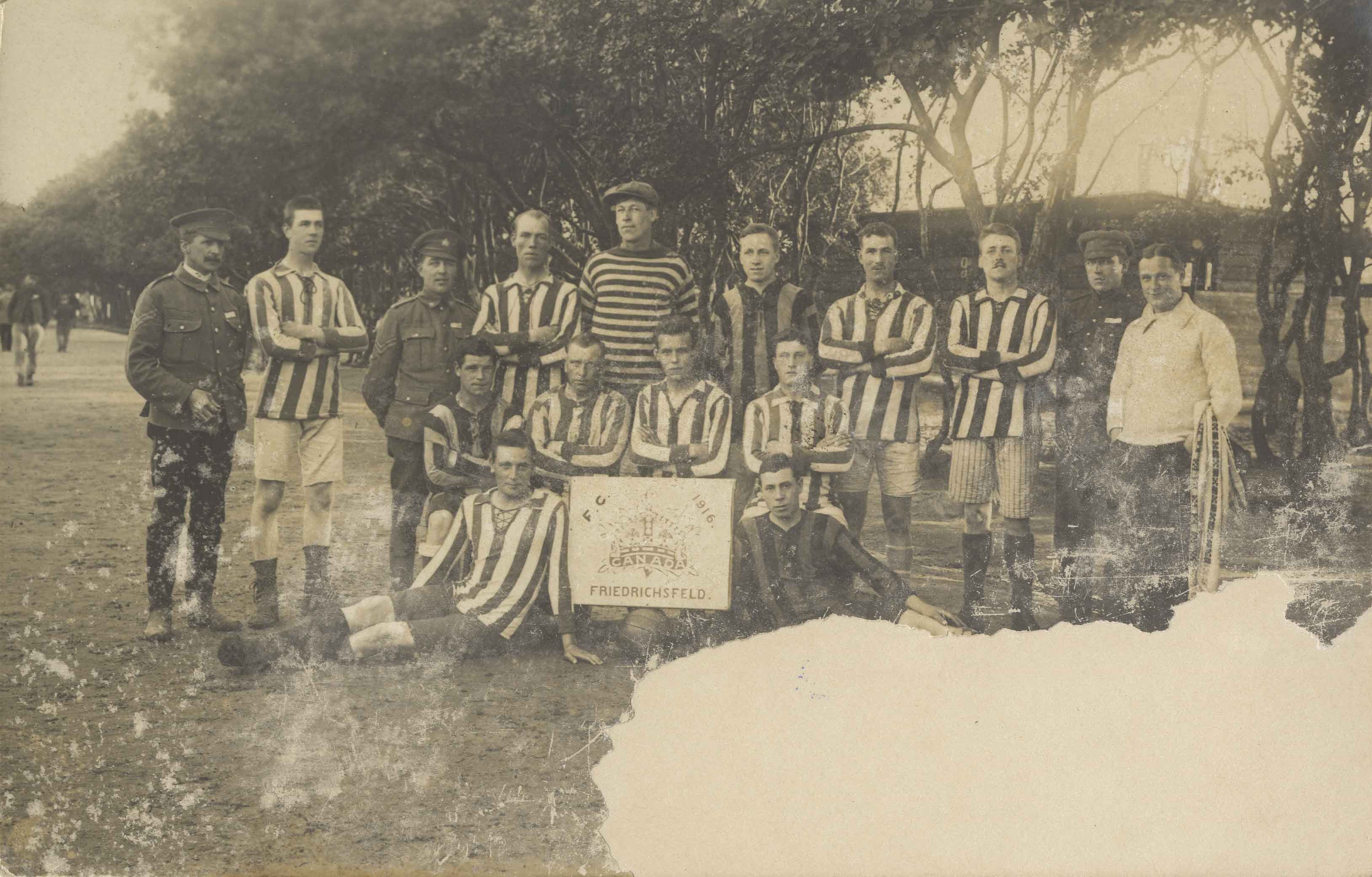
Unidentified sports team
https://search.heritageburnaby.ca/link/archivedescription82566
- Repository
- City of Burnaby Archives
- Date
- 1916
- Collection/Fonds
- Hill family and Vidal family fonds
- Description Level
- Item
- Physical Description
- 1 photograph : sepia postcard ; 14 x 9 cm
- Scope and Content
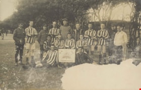
- Photographic postcard is a portrait of a sports team. Sign reads: "F. C. 1916 / Canada / Friedrichsfeld"
- Repository
- City of Burnaby Archives
- Date
- 1916
- Collection/Fonds
- Hill family and Vidal family fonds
- Physical Description
- 1 photograph : sepia postcard ; 14 x 9 cm
- Description Level
- Item
- Record No.
- 550-137
- Access Restriction
- No restrictions
- Reproduction Restriction
- No known restrictions
- Accession Number
- 2013-03
- Scope and Content
- Photographic postcard is a portrait of a sports team. Sign reads: "F. C. 1916 / Canada / Friedrichsfeld"
- Media Type
- Photograph
- Notes
- Title based on contents of photograph and note accompanying photograph
- Note in black pen on verso reads: "To: Miss K Hill / Burnaby Lake / Vancouver BC / Canada / 3rd from R back row"
Images
The volume library : a concise, graded repository of practical and cultural knowledge designed for both instruction and reference
https://search.heritageburnaby.ca/link/museumlibrary2837
- Repository
- Burnaby Village Museum
- Collection
- Special Collection
- Material Type
- Book
- Accession Code
- HV973.92.3
- Call Number
- 031 RUO
- Place of Publication
- Chicago
- Publisher
- The W.E. Richardson Company
- Publication Date
- 1912
- Physical Description
- 830 p., xviii, [8] leaves of plates : ill. (some col., maps (col.) ; 29 cm.
- Inscription
- "A. Lucas 4818 Fairlawn Dr Burnaby, BC" [handwritten in blue ink on pre-pages]
- Library Subject (LOC)
- Encyclopedias and dictionaries
- Notes
- "Editor-in-Chief Henry W. Ruoff"--title page.
- "Profusely illustrated"--title page.
- Includes index.
- Author's full given name and dates : Henry W. (Henry Woldmar) Ruoff, 1865-1935
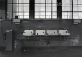
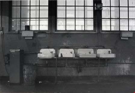
Wash Basins
https://search.heritageburnaby.ca/link/archivedescription79402
- Repository
- City of Burnaby Archives
- Date
- October, 1976
- Collection/Fonds
- Burnaby Public Library Contemporary Visual Archive Project
- Description Level
- Item
- Physical Description
- 1 photograph : b&w ; 11 x 16 cm mounted on cardboard
- Scope and Content
- Photograph shows wash basins and drinking fountain in the Dominion Bridge building, owned by BC. Hydro.
- Repository
- City of Burnaby Archives
- Date
- October, 1976
- Collection/Fonds
- Burnaby Public Library Contemporary Visual Archive Project
- Physical Description
- 1 photograph : b&w ; 11 x 16 cm mounted on cardboard
- Description Level
- Item
- Record No.
- 556-277
- Access Restriction
- No restrictions
- Reproduction Restriction
- Reproduce for fair dealing purposes only
- Accession Number
- 2013-13
- Scope and Content
- Photograph shows wash basins and drinking fountain in the Dominion Bridge building, owned by BC. Hydro.
- Media Type
- Photograph
- Photographer
- Cook, Alan
- Notes
- Scope note taken directly from BPL photograph description.
- 1 b&w copy negative : 10 x 12.5 cm accompanying
- Geographic Access
- Henning Drive
- Street Address
- 3880 Henning Drive
- Historic Neighbourhood
- Broadview (Historic Neighbourhood)
- Planning Study Area
- West Central Valley Area
Images
Way Sang Yuen Wat Kee & Co.
https://search.heritageburnaby.ca/link/museumdescription4648
- Repository
- Burnaby Village Museum
- Date
- 1908-1975
- Collection/Fonds
- Way Sang Yuen Wat Kee & Co. fonds
- Description Level
- Fonds
- Physical Description
- 3 folders of textual records + 180 photographs + ephemera + 1 map + 1 architectural drawing
- Scope and Content
- Fonds consists of records acquired from the Chinese Herbalist shop “Way Sang Yuen Wat Kee & Co” operating in Victoria from 1905 until 1968. Textual records include a few pieces of correspondence, receipts and ephemera addressed to "Way Sang Yuen Wat Kee & Co.", Lim You and Lim Yau (Yew Long Lum) wh…
- Repository
- Burnaby Village Museum
- Collection/Fonds
- Way Sang Yuen Wat Kee & Co. fonds
- Description Level
- Fonds
- Physical Description
- 3 folders of textual records + 180 photographs + ephemera + 1 map + 1 architectural drawing
- Scope and Content
- Fonds consists of records acquired from the Chinese Herbalist shop “Way Sang Yuen Wat Kee & Co” operating in Victoria from 1905 until 1968. Textual records include a few pieces of correspondence, receipts and ephemera addressed to "Way Sang Yuen Wat Kee & Co.", Lim You and Lim Yau (Yew Long Lum) while the shop was in operation at 1620 Government Street in the 1940s. Some of the records are written in English while a portion are written in Cantonese and haven't been translated. Most of the photographs document the content of the original shop at the time of aquistion in 1975. Some photographs of unidentified people may be related to the owner or proprietor of the shop. A collection of other photographs document various Chinese Canadian organizations that were in operation in Victoria. Records are arranged into the following series: 1) Way Sang Yuen Wat Kee & Co. photographs series 2) Way Sang Yuen Wat Kee & Co. documents series
- History
- The Chinese Herbalist shop "Way Sang Yuen Wat Kee & Co" operated in Victoria, BC from about 1905 until [1968]. The meaning of "Way Sang Yuen Wat Kee & Co" can be translated as "Collection, Life, Source, Alive, Shop" although many interpretations can be taken since each Chinese character can have several meanings. Contents of the shop were purchased by the Burnaby Village Museum in 1975 and reassembled as a permanent display in the Burnaby Village Museum. The shop’s original owner was Ng Chee Fong who opened the shop ca.1905. In 1921, Ng returned to Hong Kong and sold the business to Lam Yuen and Wong Ying who were from Vancouver. Lam Yuen and Wong Ying employed Lum Chuck Yue to operate the shop. Lum Chuck Yue had formerly operated a small herbal counter in a Chinese apothecary store on the south side of Fisgard Street, Victoria. In 1924 Lam Yuen and Wong Ying purchased Wah Sun & Co. from Lee S. Yew and Way Sang Yuen Wat Kee & Co. moved into the Wah Sun premises at 1620 Government Street in the Lee Block . The furnishings and fixtures of both stores were combined, with the more elaborate fixtures from WSYWK remaining as part of the public part of the shop and the plainer fixtures of Wah Sun moved into the workroom and basement. In the 1930s Lum Chuck Yue took over the business and became the proprietor. In about 1934, Tan Yi Tang purchased the business and the shop reopened as Way Sang Yuen Wat Kee & Co. following renovations with Lum Yew Jong as the shop's proprietor. Lum Yew Jong continued to operate the shop until his death in 1967 at the age of 68 years. Following Lum’s death, the property and contents of the shop were purchased by Mr. J. Watson Marles, a local owner operator of an antique store at 1714 Government Street. The shop and contents went through a few more private owners including Rodney Pain before it was purchased by the Heritage Village Museum in 1975 with funds made available by the Vancouver Foundation and the Province of British Columbia. Contents of the original shop were reasembled in a reconstructed building as a permanent display on site at the Burnaby Village Museum.
- Creator
- Way Sang Yuen Wat Kee & Company
- Accession Code
- HV975.5
- BV985.5331
- BV017.7
- Access Restriction
- Restricted access
- Reproduction Restriction
- May be restricted by third party rights
- Date
- 1908-1975
- Related Material
- See also Artifacts under Accessions HV975.5; BV985.5331 and BV017.7
- Notes
- Title based on contents of fonds

Widening of Scott Road
https://search.heritageburnaby.ca/link/archivedescription56677
- Repository
- City of Burnaby Archives
- Date
- March 1976, published March 24, 1976
- Collection/Fonds
- Columbian Newspaper collection
- Description Level
- Item
- Physical Description
- 1 photograph : b&w ; 7.5 x 14 cm
- Scope and Content
- Photograph of the process of widening Scott Road in Surrey BC. The process was undertaken by the provincial government. Citizens were upset as this process included cutting down century-old trees (stumps of these former trees are visible in this photograph).
- Repository
- City of Burnaby Archives
- Date
- March 1976, published March 24, 1976
- Collection/Fonds
- Columbian Newspaper collection
- Physical Description
- 1 photograph : b&w ; 7.5 x 14 cm
- Description Level
- Item
- Record No.
- 480-531
- Access Restriction
- No restrictions
- Reproduction Restriction
- No restrictions
- Accession Number
- 2003-02
- Scope and Content
- Photograph of the process of widening Scott Road in Surrey BC. The process was undertaken by the provincial government. Citizens were upset as this process included cutting down century-old trees (stumps of these former trees are visible in this photograph).
- Media Type
- Photograph
- Photographer
- King, Basil
- Notes
- Title based on contents of photograph
- Newspaper clipping attached to verso of photograph reads: "Road-widening on Scott Rd. in Surrey has taken its toll of old trees."
Images

William H. Burke
https://search.heritageburnaby.ca/link/archivedescription45134
- Repository
- City of Burnaby Archives
- Date
- 1972
- Collection/Fonds
- Columbian Newspaper collection
- Description Level
- Item
- Physical Description
- 1 photograph : b&w ; 14.5 x 10 cm
- Scope and Content
- Photograph of William H. Burke, a BC Hydro Armoured Car Attendant. He had been a Burnaby School Trustee for six years when he used this photograph in his election campaign to become re-elected.
- Repository
- City of Burnaby Archives
- Date
- 1972
- Collection/Fonds
- Columbian Newspaper collection
- Physical Description
- 1 photograph : b&w ; 14.5 x 10 cm
- Description Level
- Item
- Record No.
- 480-030
- Access Restriction
- No restrictions
- Reproduction Restriction
- Reproduce for fair dealing purposes only
- Accession Number
- 2003-02
- Scope and Content
- Photograph of William H. Burke, a BC Hydro Armoured Car Attendant. He had been a Burnaby School Trustee for six years when he used this photograph in his election campaign to become re-elected.
- Subjects
- Officials - Elected Officials
- Names
- Burnaby School Trustees
- Media Type
- Photograph
- Photographer
- Burnaby Photographers
- Notes
- Title based on contents of photograph
Will power and success
https://search.heritageburnaby.ca/link/museumlibrary1724
- Repository
- Burnaby Village Museum
- Collection
- Special Collection
- Material Type
- Book
- Accession Code
- HV984.21.38
- Call Number
- 150 BUS
- Place of Publication
- St. Louis, Mo.
- Publisher
- D. V. Bush
- Publication Date
- c1916
- Physical Description
- 277 p. ; 20 cm.
- Inscription
- Front endpaper: "Chrissie Youngson" [written in pencil] Front fly leaf: "1922. Chrissie Youngson. 3854 Union St. Vancouver, BC." [written in black ink]
- Notes
- Full author name given as: Bush, David V. (David Van), 1882-
Ernest Winch fonds
https://search.heritageburnaby.ca/link/archivedescription64651
- Repository
- City of Burnaby Archives
- Date
- 1898-1961
- Collection/Fonds
- Ernest Winch fonds
- Description Level
- Fonds
- Physical Description
- 15 cm of textual records and 31 photographs
- Scope and Content
- Fonds consists of photographs, political leaflets, postcards, publications, correspondence and a scrapbook documenting the political careers of Ernest and Harold Winch.
- Repository
- City of Burnaby Archives
- Date
- 1898-1961
- Collection/Fonds
- Ernest Winch fonds
- Physical Description
- 15 cm of textual records and 31 photographs
- Description Level
- Fonds
- Accession Number
- 2010-06
- Scope and Content
- Fonds consists of photographs, political leaflets, postcards, publications, correspondence and a scrapbook documenting the political careers of Ernest and Harold Winch.
- History
- Ernest Edward (Ernie) Winch was born at Harlow, Essex, England on March 22, 1879. Ernest was one of seven children; Walter, Albert, Alfred, Horace, Ernest, Emma and Caroline (Carrie). In 1898, when he was 19 years old, Ernest immigrated to Canada with his friend Jack Holttum to work on a farm in Saskatchewan. Ernest’s brother Alfred followed soon after and together the Winch brothers worked in British Columbia, then in Australia. Unfortunately the country was at the height of a heavy drought and so Ernest returned to Harlow and followed in his father's footsteps, apprenticing as a bricklayer. In 1905 Ernest Winch met and married Australian born Linda Marian Hendy. While in England they had Harold, born June 18, 1907, and Eileen, born in 1908. Ernest sailed back to Canada alone in 1910, his young family following him months later. He quickly became a member of the Bricklayers and Masons International Union No. 1, Vancouver Branch. Ernest began studying socialism in 1910 and joined the Social-Democratic Party of Canada in 1911. The Burnaby local of the Social-Democratic Party nominated Ernest Winch as a candidate for School Trustee in 1914. He received seven votes. In 1915 he and his eldest son Harold left the rest of the family at their home in White Rock and went to Mission to establish a homestead. While living in the Dewdney area, he organized a small Social-Democratic group in Mission and became its Secretary. However, he did not stay long in Dewdney. In the summer of 1918, Ernest left the Social-Democratic Party to join the Socialist Party. Once back in Burnaby, now 38 years old and looking for a way to support his family, Ernest answered a call for new workers from the Longshoremen’s Union. He joined the International Longshoremen's Association (ILA) Auxiliary and soon was elected its Secretary. By 1917, he was a part of the Vancouver Trades and Labour Council, serving as its President by 1918. In 1919, he joined the B.C. Loggers Union (later the Lumber-Workers Industrial Unit), serving as Secretary. Ernest endorsed both the Vancouver General Strike in 1918 and the Winnipeg General Strike of 1919 and was active in his support of the One Big Union (O.B.U). After two and a half years, Ernest left the ILA and rejoined the Longshoremen’s Union along with his former O.B.U. brother, William A. Pritchard. Soon after, a strike broke out and its unsuccessful end caused Winch to go back to bricklaying. By this time, the four youngest Winch children had been born: Charlie, Grace, Alan and Eric. Ernest re-founded the Socialist Party of Canada (British Columbia) in 1932 and, with it, joined the new Co-operative Commonwealth Federation. In the 1933 provincial election he, his son Harold Winch, and five others became the first CCF Members of Legislative Assembly. As a CCF MLA for Burnaby, Ernest became a resolute advocate for immediate reform, exposing abuses and inadequacies in BC's social welfare and correctional institutions (including Oakalla) and taking a special interest in the problems of the aged. One of his many notable contributions was the creation of the New Vista Society, first developed to ease the problem of overcrowding in mental hospitals at the time. Ernest Winch held his seat in the legislature continuously until his death on January 11, 1957. One of his legacies left to the people of Burnaby are the New Vista Society senior citizens homes. He also founded the New Westminster branch of the Society for the Prevention of Cruelty to Animals (S.P.C.A.). Ernest and Linda’s eldest son Harold Edward, an electrician by trade, married Dorothy Ada Hutchinson on May 11, 1929. At 26 years old, he was elected CCF MLA for Vancouver East (in 1933) and became provincial party leader by 1938, serving as leader of the Opposition from 1941 to 1953. When the CCF was defeated in the controversial election of 1953, which saw W.A.C. Bennet come to power, Harold abandoned provincial politics for the House of Commons, where he represented Vancouver East until his retirement in 1972.
- Media Type
- Textual Record
- Photograph
- Creator
- Winch, Ernest "Ernie"
- Notes
- Title based on contents of fonds
- MSS129, photo catalogue 514