Narrow Results By
Creator
- Aitkenhead, May 1
- Bartel, Mario 36
- Brandson, Lloyd S. 1
- Burnett & McGugan, Engineers and Surveyors 1
- Chapman, Fred 1
- Galbraith, Eleanor Lois 1
- Garden, Hermon and Burwell 1
- Garden, Hermon & Burwell 1
- Gauvreau, Narcisse B. 1
- Government of Canada - Department of Mines - Geological Survey Branch 1
- Hill, Albert James 3
- Knudson, Art 1
Person / Organization
- Alpha Secondary School 4
- BC Society of Model Engineers (BCSME) 3
- Begin, Gary 1
- Bill Copeland Sports Centre 1
- Boy Scouts of Canada 4
- Burnaby Central Secondary School 2
- Burnaby Clef Society 1
- Burnaby Fire Department 1
- Burnaby General Hospital 1
- Burnaby Historical Society 2
- Burnaby Village Museum 2
- Burnaby Winter Club 1
Provincial Council of Women papers
https://search.heritageburnaby.ca/link/archivedescription58050
- Repository
- City of Burnaby Archives
- Date
- 1968-1984
- Collection/Fonds
- Burnaby Historical Society fonds
- Description Level
- File
- Physical Description
- 1 file of textual records
- Scope and Content
- File consists of papers pertaining to the Provincial Council of Women including meeting minutes, reports, correspondence and a Provincial Council of Women of BC directory which includes phone numbers, addresses and positions of each of the members from 1968.
- Repository
- City of Burnaby Archives
- Date
- 1968-1984
- Collection/Fonds
- Burnaby Historical Society fonds
- Subseries
- Eagles family subseries
- Physical Description
- 1 file of textual records
- Description Level
- File
- Record No.
- MSS055-007
- Access Restriction
- Subject to FOIPPA
- Reproduction Restriction
- Reproductions subject to FOIPPA
- Accession Number
- BHS1991-18
- Scope and Content
- File consists of papers pertaining to the Provincial Council of Women including meeting minutes, reports, correspondence and a Provincial Council of Women of BC directory which includes phone numbers, addresses and positions of each of the members from 1968.
- Media Type
- Textual Record
- Notes
- Title based on contents of file
Purple Loosestrife
https://search.heritageburnaby.ca/link/archivedescription88985
- Repository
- City of Burnaby Archives
- Date
- 1993
- Collection/Fonds
- Doreen Lawson fonds
- Description Level
- File
- Physical Description
- 1 folder of textual records
- Scope and Content
- File consists of a presentation and an essay written by Doreen Lawson regarding the purple loosestrife as an invasive species. The presentation script is entitled "Management Considerations for Purple Loosestrife" which Doreen presented on April 22, 1993 and the essay is entitled " Loosestrife on …
- Repository
- City of Burnaby Archives
- Date
- 1993
- Collection/Fonds
- Doreen Lawson fonds
- Physical Description
- 1 folder of textual records
- Description Level
- File
- Record No.
- MSS071-014
- Access Restriction
- Open access
- Accession Number
- 2003-30
- Scope and Content
- File consists of a presentation and an essay written by Doreen Lawson regarding the purple loosestrife as an invasive species. The presentation script is entitled "Management Considerations for Purple Loosestrife" which Doreen presented on April 22, 1993 and the essay is entitled " Loosestrife on the Loose" which was published in "BC Naturalist", January/February 1993, Vol. 31, No. 1.
- Media Type
- Textual Record
- Notes
- Title based on contents of file

Royal visit photographs
https://search.heritageburnaby.ca/link/archivedescription96965
- Repository
- City of Burnaby Archives
- Date
- May 6, 1986
- Collection/Fonds
- Mayor s Office fonds
- Description Level
- File
- Physical Description
- 34 photographs : col. ; 8.5 x 12.5 cm and 9 x 13 cm
- Scope and Content
- Photographs of the Royal visit of Charles, Prince of Wales, and Diana, Princess of Wales, to Burnaby on May 6, 1986. Photographs depict: the ceremony held in Central Park; the BC Tel building at Boundary & Kingsway with a welcome banner; the crowds in attendance; and various officials, including Ma…
- Repository
- City of Burnaby Archives
- Date
- May 6, 1986
- Collection/Fonds
- Mayor s Office fonds
- Physical Description
- 34 photographs : col. ; 8.5 x 12.5 cm and 9 x 13 cm
- Description Level
- File
- Record No.
- 626-001
- Access Restriction
- No restrictions
- Reproduction Restriction
- Reproduce for fair dealing purposes only
- Accession Number
- 2001-01
- Scope and Content
- Photographs of the Royal visit of Charles, Prince of Wales, and Diana, Princess of Wales, to Burnaby on May 6, 1986. Photographs depict: the ceremony held in Central Park; the BC Tel building at Boundary & Kingsway with a welcome banner; the crowds in attendance; and various officials, including Mayor William Lewarne and the Mayor of Loughborough, England.
- Names
- Charles, Prince of Wales, 1948-
- Diana, Princess of Wales, 1961-1997
- Lewarne, William A. "Bill"
- Media Type
- Photograph
- Notes
- Title based on contents of file
- Geographic Access
- Kingsway
- Central Park
- Boundary Road
- Historic Neighbourhood
- Central Park (Historic Neighbourhood)
- Planning Study Area
- Maywood Area
Images

School files - Burnaby South Secondary School
https://search.heritageburnaby.ca/link/archivedescription66589
- Repository
- City of Burnaby Archives
- Date
- 1942-2007
- Collection/Fonds
- Burnaby Historical Society fonds
- Description Level
- File
- Physical Description
- 1 file of textual records
- Scope and Content
- File consists of newspaper clippings and other paper records pertaining to Burnaby South Secondary School and the BC Provincial School for the Deaf. Included in the file is a 1944 Home Economics Circular suggesting healthy recipes for school lunches as well as the September 1942 issue of the school…
- Repository
- City of Burnaby Archives
- Date
- 1942-2007
- Collection/Fonds
- Burnaby Historical Society fonds
- Subseries
- School files subseries
- Physical Description
- 1 file of textual records
- Description Level
- File
- Record No.
- 43073
- Accession Number
- BHS2007-04
- Scope and Content
- File consists of newspaper clippings and other paper records pertaining to Burnaby South Secondary School and the BC Provincial School for the Deaf. Included in the file is a 1944 Home Economics Circular suggesting healthy recipes for school lunches as well as the September 1942 issue of the school newsletter "Argus."
- Media Type
- Textual Record
- Notes
- Title based on contents of file
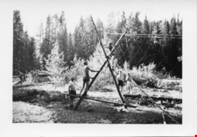
![Scouting activities, [between 1960 and 1980] thumbnail](/media/Hpo/_Data/_Archives_Images/_Unrestricted/629/631-029-1.jpg?width=280)
Scouting activities
https://search.heritageburnaby.ca/link/archivedescription98032
- Repository
- City of Burnaby Archives
- Date
- [between 1960 and 1980]
- Collection/Fonds
- Burnaby Historical Society fonds
- Description Level
- File
- Physical Description
- 22 photographs : b&w ; 9 cm x 11 cm and smaller
- Scope and Content
- Photographs of various Scouting activities and trips. Activities include forgaging, hiking, flag raising, races, and badge presentations; trips include Penticton BC, Jones Creek, Brandywine Mountain, and Mount Brew.
- Repository
- City of Burnaby Archives
- Date
- [between 1960 and 1980]
- Collection/Fonds
- Burnaby Historical Society fonds
- Subseries
- Burnaby Scouts subseries
- Physical Description
- 22 photographs : b&w ; 9 cm x 11 cm and smaller
- Description Level
- File
- Record No.
- 631-029
- Access Restriction
- No restrictions
- Reproduction Restriction
- May be restricted by third party rights
- Accession Number
- BHS1994-05
- Scope and Content
- Photographs of various Scouting activities and trips. Activities include forgaging, hiking, flag raising, races, and badge presentations; trips include Penticton BC, Jones Creek, Brandywine Mountain, and Mount Brew.
- Names
- Boy Scouts of Canada
- Media Type
- Photograph
- Notes
- Title based on content of photographs
- Album note for photograph 631-029-1 read: "Bill O'Doherty Geo L."
- Album note for photograph 631-029-2 read: "Geo Lydiard"
- Album note for photograph 631-029-4 read: "Pat Connell and George Couteriar"
- Note in blue ink on verso of photograph 631-029-5 reads: "Dave Fowler Bob Maurice 6th Ctr."
- Album note for photograph 631-029-6 read: 'Back Row Left to Right: ? , Bob Nisley, Jerry Balcuk, JOhn Cullen, Alan Dawson, Gerald Derwoon, Dave Nosella, Glen [illegible]
- Album note for photograph 631-029-8 read: "White Hats Burrard". Note in blue ink on verso of photograph reads: "Camp Sweat Brandy Wine Mtn."
- Note in blue ink on verso of photograph 631-029-9 reads: "Camp Sweat Brandy Wine Mtn."
- Album note for photographs 631-029-10 and -11 read: "Dave Fisher says this is Mt. Brew looking across at the Chimney of Black Tusk." Note in blue ink on verso of photograph 631-029-10 and -11 reads: "Camp Sweat Brandy Wine Mtn."
- Note in pencil on verso of photograph 631-029-12 reads: "Venturers 1966"
- Album note for photograph 631-029-13 read: "Hamish Bullen". Note in pencil on verso of photograph reads: "Pentiction Apr '66".
- Album note for photograph 631-029-15 read: "Hugh Martin at bus door Jones Creek?"
- Album note for photograph 631-029-17 read: "Geo Lydiard"
Images
![Scouting activities, [between 1960 and 1980] thumbnail](/media/Hpo/_Data/_Archives_Images/_Unrestricted/629/631-029-1.jpg)
Society correspondence and ephemera
https://search.heritageburnaby.ca/link/archivedescription98395
- Repository
- City of Burnaby Archives
- Date
- 1957-1989
- Collection/Fonds
- Burnaby Historical Society fonds
- Description Level
- File
- Physical Description
- 1 cm of textual records, 2 technical drawings, and 3 photographs : b&w ; 14.5 cm x 9 cm
- Scope and Content
- File contains Burnaby Historical Society correspondence and ephemera, including flyers, invitations, logo designs, and copies of BC Historical Association newsletters. File also includes correspondence and two technical drawings related to the Society's Burnaby Lake interurban tram project and pho…
- Repository
- City of Burnaby Archives
- Date
- 1957-1989
- Collection/Fonds
- Burnaby Historical Society fonds
- Series
- Administration series
- Physical Description
- 1 cm of textual records, 2 technical drawings, and 3 photographs : b&w ; 14.5 cm x 9 cm
- Description Level
- File
- Record No.
- MSS205-068
- Access Restriction
- No restrictions
- Accession Number
- 2020-06
- Scope and Content
- File contains Burnaby Historical Society correspondence and ephemera, including flyers, invitations, logo designs, and copies of BC Historical Association newsletters. File also includes correspondence and two technical drawings related to the Society's Burnaby Lake interurban tram project and photographs of Mrs. George Westover, Mrs. Barry Mather, and Miss Bessie Choate picnicking in Fort Langley.
- Names
- Choate, Bessie Perley
- Media Type
- Textual Record
- Technical Drawing
- Photograph
- Notes
- Title based on contents of file
- Original file folder titled: "General Meeting Sept 10/08"
- Photographs assigned item no. 633-002-1:633-002-3. Photographs in original location within folder.
![Subdivision plans in New Westminster District Group 1 – Burnaby
, [1890-1910] thumbnail](/media/hpo/_Data/_BVM_Cartographic_Material/1977/1977_0093_0014a_001.jpg?width=280)
Subdivision plans in New Westminster District Group 1 – Burnaby
https://search.heritageburnaby.ca/link/museumdescription6983
- Repository
- Burnaby Village Museum
- Date
- [1890-1910]
- Collection/Fonds
- Burnaby Village Museum Map collection
- Description Level
- File
- Physical Description
- 4 plans : blueprint ink on paper mounted on 2 sides of cardboard 76 x 102 cm
- Scope and Content
- Item consists of a large board of two New Westminster District Gp 1 - subdivision plans mounted on one side and two New Westminster District Gp 1 - subdivision plans mounted on the other side. Side A: 1. Blueprint "Plan of / Subdivision of Lot No. 69 / Group One / New Westminster District / Pro…
- Repository
- Burnaby Village Museum
- Collection/Fonds
- Burnaby Village Museum Map collection
- Description Level
- File
- Physical Description
- 4 plans : blueprint ink on paper mounted on 2 sides of cardboard 76 x 102 cm
- Material Details
- Scales [between 1:1584 and 1:3168]
- Index number on edge of board reads: "14"
- Scope and Content
- Item consists of a large board of two New Westminster District Gp 1 - subdivision plans mounted on one side and two New Westminster District Gp 1 - subdivision plans mounted on the other side. Side A: 1. Blueprint "Plan of / Subdivision of Lot No. 69 / Group One / New Westminster District / Property of Ernest Buse, Esq. / Scale 3 chs = 1 in. / Map No 290". Plan is signed by "Garden, Hermon and Burwell, Dom. Land Surveyor" (Geographic location: Burnaby) 2. Blueprint "Plan / of Subdivision / of Lots 1-19, 36-53 and 69-75 inclusive / in the Subdivision / of / Lot 30 / Group One / New Westminster District / Scale 2 chs = 1 in. Map No 631". Plan is signed by "Jno [sic] Strathern [sic] P.L.S." Names and Lot numbers are handwritten in red pencil in sections along Douglas Road and read: "20 - F / 21 - Fitherstruhaul [sic] / 22 - J.S. Craig / 23 - McGill & Dill / 24 / 25 / 26 / 27 / 28 - School / 29 - School / 30 - D. McDownall / 31 - W.J. Troloow [sic] / 32 - N.C. Nelson / 33 - _[sic] McGill / 34 - T.S.[sic] Craig / 35" (Geographic location: Burnaby) Side B: 1.Blueprint "Plan / of Subdivision / of Centre Portion / of Lot 28 / Group One / New Westminster District / Scale 200' = 1" / Map No 627". Plan is signed by "Jno Strathern / P.L.S." (Geographic location: Burnaby) 2. Blueprint "Plan / of Subdivision / of N.1/2 Lot 100 and S.1/2 Lot 101, / Group One / New Westminster District, BC / Scale 4 chs = 1 in." (Geographic location: Burnaby)
- Names
- Strathern, John
- Accession Code
- HV977.93.14
- Access Restriction
- No restrictions
- Reproduction Restriction
- No known restrictions
- Date
- [1890-1910]
- Media Type
- Cartographic Material
- Historic Neighbourhood
- Broadview (Historic Neighbourhood)
- East Burnaby (Historic Neighbourhood)
- Planning Study Area
- Cascade-Schou Area
- West Central Valley Area
- Second Street Area
- Lake City Area
- Scan Resolution
- 300
- Scale
- 72
- Notes
- Title based on contents of file
- Scale is measured in chains and feet. (One chain equals 792 inches)
- The term "Lot" can also refer to a "District Lot”
Images
![Subdivision plans in New Westminster District Group 1 – Burnaby
, [1890-1910] thumbnail](/media/hpo/_Data/_BVM_Cartographic_Material/1977/1977_0093_0014a_001.jpg)


Subdivision plans in New Westminster District Group 1 – Burnaby, Vancouver and map - Canada Department of Mines
https://search.heritageburnaby.ca/link/museumdescription6994
- Repository
- Burnaby Village Museum
- Date
- 1890-1909
- Collection/Fonds
- Burnaby Village Museum Map collection
- Description Level
- File
- Physical Description
- 1 plan : graphite on paper + 2 plans : black ink on paper + 1 map : col. on paper mounted on 2 sides of cardboard 76 x 102 cm
- Scope and Content
- Item consists of a large board with one New Westminster District subdivision plan mounted on one side and two New Westminster District subdivision plans and one colour map mounted on the other side. Side A: 1. "Plan / of Subdivision of / Blocks 2, 3, 4, 5, 6 / Lot 77 / Group 1 / New Westminster D…
- Repository
- Burnaby Village Museum
- Collection/Fonds
- Burnaby Village Museum Map collection
- Description Level
- File
- Physical Description
- 1 plan : graphite on paper + 2 plans : black ink on paper + 1 map : col. on paper mounted on 2 sides of cardboard 76 x 102 cm
- Material Details
- Scales 1:720 and 1:1200 and 1:.00001578
- Scope and Content
- Item consists of a large board with one New Westminster District subdivision plan mounted on one side and two New Westminster District subdivision plans and one colour map mounted on the other side. Side A: 1. "Plan / of Subdivision of / Blocks 2, 3, 4, 5, 6 / Lot 77 / Group 1 / New Westminster District / BC. / Scale 100 feet = 1 inch", "Deposited 8th day / of April 1890 / Mowileg [sic] / Dist. Regt". Plan is drawn in graphite with annotations: "AB_Parts_lettered_are_lots_in / the_different_subdivisions" / "Owners: / James E. Hall / P.S.Cabilan [sic] by his attorney Joseph Hall / Joseph Hall / Eliza J. Shannon / John Harrison"; "This plan is correct and is prepared under the / provisions of the Land Registry Act" ; signed by: "Gordon Herman & Burwell / Dominion & Provincial Land Surveryors / Vancouver March 19th/90" . Plan is initialed by: "RB" [sic] (in blue pencil crayon) and measures: 99.5 x 65 cm (Geographic location: Burnaby) Side B: 1. Map titled "Canada / Department of Mines / Geological Survey Branch" / "Hon.W Templeton, Minister / A.P. Low, Deputy Minister / R.W. Brock, Acting Director", Vol. XXXI, Plate I / Compiled under the direction of / James White, F.R.G.S. Geographer /Dep. of Interior". Note above map reads: "To illustrate Mr. James Barrowman's report as Delegate at the Excursion - meeting of the Canadian Mining Institute", "The instiitution of Mining Engineers / Transactions 1908 - 1909", "The Mining Institute of Scotland / Transactions 1908-1909". Map identifies minerals and includes a Legend and Scale: 100 miles = 1 inch 2. "Plan / of Subdivision of / Lot 4 / of Subdivision of / Lot 87. Gr. 1 / New Westminster District / Scale 60' = 1in." Plan is initialed by: "RB" [sic] along with a note "also Board / 48" (in blue pencil crayon) (Geographic location: Burnaby) 3. Plan of "Lot 335 / G. 1" west of Boundary Road and north of River Road - Vancouver. (Geographic location: Vancouver)
- Publisher
- The Mining Institute of Scotland
- Geographic Access
- Vancouver
- Accession Code
- HV977.93.25
- Access Restriction
- No restrictions
- Reproduction Restriction
- No known restrictions
- Date
- 1890-1909
- Media Type
- Cartographic Material
- Scan Resolution
- 300
- Scale
- 72
- Notes
- Title based on contents of file
- Scale is measured in feet and miles.
- The term "Lot" often refers to "District Lot"
Images


![Survey and Subdivision plans in New Westminster District Group 1 - Burnaby
, [1906-1910] thumbnail](/media/hpo/_Data/_BVM_Cartographic_Material/1977/1977_0093_0001a_001.jpg?width=280)
Survey and Subdivision plans in New Westminster District Group 1 - Burnaby
https://search.heritageburnaby.ca/link/museumdescription6970
- Repository
- Burnaby Village Museum
- Date
- [1906-1910]
- Collection/Fonds
- Burnaby Village Museum Map collection
- Description Level
- File
- Physical Description
- 7 plans : blueprint ink on paper + 2 plans : black ink on paper mounted on 2 sides of cardboard 76 cm x 102 cm
- Scope and Content
- Item consists of a large board of six New Westminster District Gp 1 subdivision plans mounted on one side and three New Westminster District Gp 1 subdivision plans mounted on the other side with scales ranging from one chain equals one inch to four chains equals one inch. Side A: 1. Blueprint "Pl…
- Repository
- Burnaby Village Museum
- Collection/Fonds
- Burnaby Village Museum Map collection
- Description Level
- File
- Physical Description
- 7 plans : blueprint ink on paper + 2 plans : black ink on paper mounted on 2 sides of cardboard 76 cm x 102 cm
- Material Details
- Scales [1:792] and [1:3168]
- Index number on edge of board reads: "1"
- Scope and Content
- Item consists of a large board of six New Westminster District Gp 1 subdivision plans mounted on one side and three New Westminster District Gp 1 subdivision plans mounted on the other side with scales ranging from one chain equals one inch to four chains equals one inch. Side A: 1. Blueprint "Plan / of Subdivision / of a portion / of / Lot 13, GR.1 / New Westminster District". Plan is bordered by Cumberland Street, Tenth Ave., Cariboo Street, Armstrong Street, "See Bd.145", Map No891 (Geographic location: Burnaby) 2."Plan / of Subdivision / of a portion / of / Lot 13, GR.1 / New Westminster District". Plan is bordered by Cumberland Street, Tenth Ave., Cariboo St. and Armstrong St. Pencilled annotations on plan read: "for Subdivisions see Board 145"; "Subdivided by H. Neville Smith". (Geographic location: Burnaby) 3. Blueprint "Plan / of Subdivision / of a part / of / Lot 155 / Group 1 / New Westminster District". Plan is bordered by North Arm of Fraser, Wiggins Rd. and Lot 173. Plan created by "NB Gauvreau" (Geographic location: Burnaby) Side B: 1. Blueprint plan which reads: "Albert J. Hill / P.L.S." at top with handwritten annotation: "Lot 85". The plan is bordered by Hastings Rd. and Burnaby Lake with names on lots identified as:"Laura Troop; Jas. Anderson and A. de W. Haszard". (Geographic location: Burnaby) 2. Blueprint plan which reads: "Albert J. Hill / P.L.S" at top with handwritten annotation: "Lot 85". The plan is bordered by Hastings Rd. and Burnaby Lake with names on lots identified as:"Laura Troop; A. de W. Haszard". (Geographic location: Burnaby) 3.Plan of "Survey of Road / for / Burnaby Council". "Albert J. Hill, M.A. Civil Engineer". Plan identifies "Centre Line Lot 10 / Present Road" at the centre and is bordered by Gunn Rd. at the top and Brunette River at the bottom. (Geographic location: Burnaby) 4.Blueprint "Plan / of Subdivision / Lot 97 Group 1/ N.W.D." Plan is bordered by Lots 93, 94 and 96 and Webster Road. Vancouver and New Westminster Road crosses the upper right corner of the plan and the New Westminster Vancouver Tramway runs through from Power House Rd. to Webster Road. Lower right corner identifies "W.N. Draper, P.LotS." (Geographic location: Burnaby) 5. Blueprint "Plan / of / The Subdivision of / Portion of / Lot 85, GP.1 / New Westminster District" Plan is bordered by Lots 79 / Byrne Drive; Burnaby Lake/ Esplanade and Lot 87. Plan is identified with "Albert J. Hill / B.C.LotS. / 19/6/09" (Geographic location: Burnaby) 6. Blueprint "Plan / of Subdivision/ of / Lot 155B, Group One / New Westminster District". Plan is bordered by Lots 155A, 155C, 162 / Byrne Road, 166A / Wiggins Road with Spruce Street running through the middle and Westminster- Eburne Ry. Right of Way running diagonally. Plan is identified with "Albert J. Hill (Geographic location: Burnaby)
- Accession Code
- HV977.93.1
- Access Restriction
- No restrictions
- Reproduction Restriction
- No known restrictions
- Date
- [1906-1910]
- Media Type
- Cartographic Material
- Scan Resolution
- 300
- Scan Date
- 2019-07-16
- Scale
- 72
- Notes
- Title based on contents of file
- Stamp on plans reads: "ALBERT J. HILL M.A. / CIVIL ENGINEER / and / PROVINCIAL LAND SURVEYOR / NEW WESTMINSTER / BC"
- Scale is measured in chains. (One chain equals 792 inches)
Images
![Survey and Subdivision plans in New Westminster District Group 1 - Burnaby
, [1906-1910] thumbnail](/media/hpo/_Data/_BVM_Cartographic_Material/1977/1977_0093_0001a_001.jpg)

![Survey and Subdivision plans in New Westminster District Group 1 – Burnaby
, [1910] thumbnail](/media/hpo/_Data/_BVM_Cartographic_Material/1977/1977_0093_0006a_001.jpg?width=280)
Survey and Subdivision plans in New Westminster District Group 1 – Burnaby
https://search.heritageburnaby.ca/link/museumdescription6975
- Repository
- Burnaby Village Museum
- Date
- [1910]
- Collection/Fonds
- Burnaby Village Museum Map collection
- Description Level
- File
- Physical Description
- 4 plans : blueprint ink on paper ; mounted on 2 sides of cardboard 76 cm x 102 cm
- Scope and Content
- Item consists of a large board of one New Westminster District Gp 1 -subdivision plan mounted on one side and three New Westminster District Gp 1 - subdivision plans mounted on the other side. Side A: Blueprint "Plan / of Subdivision / of Lot 159 / and Portions of 158 and 95 / Group One / New We…
- Repository
- Burnaby Village Museum
- Collection/Fonds
- Burnaby Village Museum Map collection
- Description Level
- File
- Physical Description
- 4 plans : blueprint ink on paper ; mounted on 2 sides of cardboard 76 cm x 102 cm
- Material Details
- Scales [between 1:1584 and 1:3960]
- Index number on edge of board reads: "6"
- Scope and Content
- Item consists of a large board of one New Westminster District Gp 1 -subdivision plan mounted on one side and three New Westminster District Gp 1 - subdivision plans mounted on the other side. Side A: Blueprint "Plan / of Subdivision / of Lot 159 / and Portions of 158 and 95 / Group One / New Westminster District" . Plan is bordered by Gilley Station - BC Electric Railway, DL 95 to the north and DL 162 to the south. (Geographic location: Burnaby) Side B: 1. Blueprint "Subdivision / of / Lot 91 / Group One / New Westminster District / Compiled from Seven Plans on Record" (Geographic location: Burnaby) 2. Blueprint "Plan / of Subdivision / of Lot 11 / in the Subdivision / of Lots 'C', 'D' & 'G' / Lot 96 / Group One / New Westminster District". Identifier on Map reads: "Rec'd Map 976 / Board 172" 3. (Geographic location: Burnaby) 3. Blueprint plan (no title). Identifies DL 151 - Central Park, DL 32 to DL 35, DL 149 to DL 153, DL 99 and 98, DL 82 and portions of DL 38, DL 72 and DL 81 (Geographic location: Burnaby)
- Accession Code
- HV977.93.6
- Access Restriction
- No restrictions
- Reproduction Restriction
- No known restrictions
- Date
- [1910]
- Media Type
- Cartographic Material
- Scan Resolution
- 300
- Scale
- 72
- Notes
- Title based on contents of file
- Scale is measured in chains. (One chain equals 792 inches)
- The term "Lot" can also refer to a "District Lot"
Images
![Survey and Subdivision plans in New Westminster District Group 1 – Burnaby
, [1910] thumbnail](/media/hpo/_Data/_BVM_Cartographic_Material/1977/1977_0093_0006a_001.jpg)

![Svend Robinson wins election, [2000] thumbnail](/media/hpo/_Data/_Archives_Images/_Unrestricted/535/535-1696-1.jpg?width=280)
Svend Robinson wins election
https://search.heritageburnaby.ca/link/archivedescription95896
- Repository
- City of Burnaby Archives
- Date
- [2000]
- Collection/Fonds
- Burnaby NewsLeader photograph collection
- Description Level
- File
- Physical Description
- 5 photographs (tiff) : col.
- Scope and Content
- File contains photographs of Svend Robinson, NDP MP for Burnaby-Douglas, celebrating his win during the election. Photographs show Robinson's speech on TV, supporters cheering, and Robinson celebrating alone and with others.
- Repository
- City of Burnaby Archives
- Date
- [2000]
- Collection/Fonds
- Burnaby NewsLeader photograph collection
- Physical Description
- 5 photographs (tiff) : col.
- Description Level
- File
- Record No.
- 535-1696
- Access Restriction
- No restrictions
- Reproduction Restriction
- No restrictions
- Accession Number
- 2018-12
- Scope and Content
- File contains photographs of Svend Robinson, NDP MP for Burnaby-Douglas, celebrating his win during the election. Photographs show Robinson's speech on TV, supporters cheering, and Robinson celebrating alone and with others.
- Subjects
- Officials - Elected Officials
- Elections
- Names
- Robinson, Svend
- Media Type
- Photograph
- Photographer
- Bartel, Mario
- Notes
- Title based on caption
- Collected by editorial for use in a November 2000 issue of the Burnaby NewsLeader
- Caption from metadata for 535-1696-1: "Svend Robinson celebrates his victory in Burnaby-Douglas riding, at the NDP party at the Fireman's Hall."
- Caption from metadata for 535-1696-2: "As one of only two NDP members from BC to returned to office, Svend Robinson's victory speech attracts national media attention."
- Caption from metadata for 535-1696-3: "NDP supporters cheer their success in Svend Robinson's Burnaby-Douglas riding."
- Caption from metadata for 535-1696-4: "Svend Robinson acknowledges the work of his campaign team that helped re-elect him in Burnaby-Douglas riding."
- Caption from metadata for 535-1696-5: "Burnaby-Douglas MP Svend Robinson is congratulated by Joan Sawicki."
Images
![Svend Robinson wins election, [2000] thumbnail](/media/hpo/_Data/_Archives_Images/_Unrestricted/535/535-1696-1.jpg)
Training Photos
https://search.heritageburnaby.ca/link/archivedescription55154
- Repository
- City of Burnaby Archives
- Date
- 1951-1964
- Collection/Fonds
- Burnaby Historical Society fonds
- Description Level
- File
- Physical Description
- 8 photographs : b&w ; 21 cm x 25 cm and smaller
- Scope and Content
- Group portraits of Scouters taken during leader training camps at Gilwell in Manning Park, Legg Farm in Healy, and at Crescent Beach. File also includes three photographs of Scouters participating in training exercises.
- Repository
- City of Burnaby Archives
- Date
- 1951-1964
- Collection/Fonds
- Burnaby Historical Society fonds
- Subseries
- Burnaby Scouts subseries
- Physical Description
- 8 photographs : b&w ; 21 cm x 25 cm and smaller
- Description Level
- File
- Record No.
- 631-036
- Access Restriction
- No restrictions
- Reproduction Restriction
- Reproduce for fair dealing purposes only
- Accession Number
- BHS1994-05
- Scope and Content
- Group portraits of Scouters taken during leader training camps at Gilwell in Manning Park, Legg Farm in Healy, and at Crescent Beach. File also includes three photographs of Scouters participating in training exercises.
- Names
- Boy Scouts of Canada
- Media Type
- Photograph
- Notes
- 631-036-1:631-036-4 originally housed in envelop with note in blue ink reading: "Fred Adams #3 New Westr. Troop (Scouters at Gilwell '51) From: Stella Adams #9-B.P.Guild"
- Note in blue ink on verso of 631-036-1 reads: "Monkey Bridge Tresle 1951 Manning Park"
- Note in blue ink on verso of 631-036-2 reads: "L-R Don Crawley, Howard Steres, Art Skipry, Art Bourrows"
- Note in pencil on verso of 631-036-3 reads: "Archdeacon Resker "Camp Chief" at Gilwell Manning Park 1951"
- Note in pencil on verso of 631-036-4 reads: "Gilwell 1951"
- Note in pencil on verso of 631-036-6 reads: "Troop Leaders Wood Badge 1954"
- Note in pencil on verso of 631-036-7 reads: "Troop Leaders Wood Badge 1954 Legg Farm - Healy BC"
- Notes adhered to verso of 631-036-8 read: "1st Prov. Training Team Course Crescent Beach, B.C. May 1964"; "Stan Fisher Betty Forbes Don Phipps Len SMith (bby) Jo Smith"
Images

![Weddings at Playland, [1999] thumbnail](/media/hpo/_Data/_Archives_Images/_Unrestricted/535/535-3220-2.jpg?width=280)
Weddings at Playland
https://search.heritageburnaby.ca/link/archivedescription98141
- Repository
- City of Burnaby Archives
- Date
- [1999]
- Collection/Fonds
- Burnaby NewsLeader photograph collection
- Description Level
- File
- Physical Description
- 3 photographs (tiff) : b&w and col.
- Scope and Content
- File contains photographs of couples in wedding attire riding the wooden rollercoaster and other rides at Playland at the Pacific National Exhibition in Vancouver, BC.
- Repository
- City of Burnaby Archives
- Date
- [1999]
- Collection/Fonds
- Burnaby NewsLeader photograph collection
- Physical Description
- 3 photographs (tiff) : b&w and col.
- Description Level
- File
- Record No.
- 535-3220
- Access Restriction
- No restrictions
- Reproduction Restriction
- No restrictions
- Accession Number
- 2018-12
- Scope and Content
- File contains photographs of couples in wedding attire riding the wooden rollercoaster and other rides at Playland at the Pacific National Exhibition in Vancouver, BC.
- Media Type
- Photograph
- Notes
- Title based on contents of file
- Collected by editorial for use in a June 1999 issue of the Burnaby NewsLeader
Images
![Weddings at Playland, [1999] thumbnail](/media/hpo/_Data/_Archives_Images/_Unrestricted/535/535-3220-2.jpg)
![Burnaby citizens, [2000] thumbnail](/media/hpo/_Data/_Archives_Images/_Unrestricted/535/535-2385-1.jpg?width=280)
Burnaby citizens
https://search.heritageburnaby.ca/link/archivedescription96827
- Repository
- City of Burnaby Archives
- Date
- [2000]
- Collection/Fonds
- Burnaby NewsLeader photograph collection
- Description Level
- File
- Physical Description
- 3 photographs (tiff) : b&w
- Scope and Content
- File contains photographs of three prominent Burnaby citizens: Doug Williscroft, Baseball BC's Volunteer of the Year; Don Wrigley, President of the Friends of Interurban 1223 and the Burnaby Historical Society; and Doreen Lawson, a Burnaby councillor and environmentalist. Photographs depict Willisc…
- Repository
- City of Burnaby Archives
- Date
- [2000]
- Collection/Fonds
- Burnaby NewsLeader photograph collection
- Physical Description
- 3 photographs (tiff) : b&w
- Description Level
- File
- Record No.
- 535-2385
- Access Restriction
- No restrictions
- Reproduction Restriction
- No restrictions
- Accession Number
- 2018-12
- Scope and Content
- File contains photographs of three prominent Burnaby citizens: Doug Williscroft, Baseball BC's Volunteer of the Year; Don Wrigley, President of the Friends of Interurban 1223 and the Burnaby Historical Society; and Doreen Lawson, a Burnaby councillor and environmentalist. Photographs depict Williscroft posing with a baseball bat; Wrigley in the interurban tram undergoing restorations; and Lawson posing by Burnaby Lake.
- Media Type
- Photograph
- Photographer
- Bartel, Mario
- Notes
- Title based on caption
- Collected by editorial for use in an April 2000 issue of the Burnaby NewsLeader
- Caption from metadata for 535-2385-1: "Doug Williscroft, of Burnaby, is Baseball BC's Volunteer of the Year."
- Caption from metadata for 535-2385-2: "Don Wrigley, the President of the Friends of Interurban 1223, and of the Burnaby Historical Society, surveys the gutted interior of the old trolley car."
Images
![Burnaby citizens, [2000] thumbnail](/media/hpo/_Data/_Archives_Images/_Unrestricted/535/535-2385-1.jpg)