Narrow Results By
Decade
- 2020s 55
- 2010s 85
- 2000s 157
- 1990s 257
- 1980s 459
- 1970s 426
- 1960s 157
- 1950s 80
- 1940s
- 1930s 71
- 1920s 95
- 1910s
- 1900s 44
- 1890s 16
- 1880s 12
- 1870s 1
- 1860s 1
- 1850s 1
- 1840s 1
- 1830s 1
- 1820s 1
- 1810s 1
- 1800s 1
- 1790s 1
- 1780s 1
- 1770s 1
- 1760s 1
- 1750s 1
- 1740s 1
- 1730s 1
- 1720s 1
- 1710s 1
- 1700s 1
- 1690s 1
- 1680s 1
- 1670s 1
- 1660s 1
- 1650s 1
- 1640s 1
- 1630s 1
- 1620s 1
- 1610s 1
- 1600s 1
Subject
- Agriculture - Fruit and Berries 2
- Arts 1
- Arts - Paintings 1
- Buildings - Agricultural - Stables 1
- Buildings - Civic 1
- Buildings - Civic - Community Centres 1
- Buildings - Commercial 1
- Buildings - Commercial - Grocery Stores 3
- Buildings - Commercial - Restaurants 2
- Buildings - Commercial - Service Stations 1
- Buildings - Heritage 7
- Buildings - Industrial - Factories 1
Creator
- Arnold, Matthew, 1822-1888 1
- Atkinson, Frank H., 1871- 1
- Augé, Claude, 1854-1924 1
- Augé, Paul, 1881-1951 1
- Babcock, John Pease, 1855-1936 1
- Bernard R. Hill 1
- Berolzheimer, Ruth, 1886-1965 1
- Binks, James 3
- Brown, Donald N. "Don" 1
- Burnaby Art Gallery 1
- Burnaby Village Museum 9
- Buxton, George Searby 1
Interview with Toki Miyashita by Rod Fowler February 27, 1990 - Track 2
https://search.heritageburnaby.ca/link/oralhistory517
- Repository
- City of Burnaby Archives
- Date Range
- 1942-1969
- Length
- 00:07:41
- Summary
- This portion of the interview is about Toki Miyashita’s growing interest in Japanese culture and arts, studying the Japanese language after she was 22 in Montreal. She talks about how she learned paper-folding (origami), to make silk dolls, flower-arranging (Ikebana), and how to wear a kimono, and …
- Repository
- City of Burnaby Archives
- Summary
- This portion of the interview is about Toki Miyashita’s growing interest in Japanese culture and arts, studying the Japanese language after she was 22 in Montreal. She talks about how she learned paper-folding (origami), to make silk dolls, flower-arranging (Ikebana), and how to wear a kimono, and then began to teach others these skills in Montreal .
- Date Range
- 1942-1969
- Length
- 00:07:41
- Subjects
- Education
- Arts
- Persons - Japanese Canadians
- Interviewer
- Fowler, Rod
- Interview Date
- February 27, 1990
- Scope and Content
- Recording is of an interview with Toki Miyashita, conducted by Rod Fowler. Toki Miyashita was one of eleven participants interviewed as part of the SFU/Burnaby Centennial Committee's oral history series titled, "Voices of Burnaby". The interview is about Toki Miyashita’s family’s internment during WWII, her awakening interest in Japanese culture after the war, her subsequent interest in teaching others about Japanese crafts and arts, and becoming a helpful intermediary between Burnaby and visitors from Japan. The interview explores her interest in the Ainu of Japan and their possible link to the aboriginals of BC, her impressions of the Ainu carver Nuburi Toko, and her involvement in the events surrounding the creation of the sculpture “Playground of the Gods” for Burnaby Mountain. The interview also contains interesting details about the art of Japanese flower-arranging. To view “Narrow By” terms for each track expand this description and see “Notes”.
- Biographical Notes
- Toki Miyashita was born in Richmond B.C., ca. 1935, at the Nelson Brothers “fishery”, a second generation Canadian descended from the Oikawa family who settled on Don and Lion Islands (Oikawa-shima). In 1942 the Japanese Canadians in BC were forcibly moved from the coast and their belongings confiscated. Toki Miyashita, her parents, two brothers, and grandparents were first taken to Hastings Park where her father was separated from the family to work in road camps, and the rest of the family were interned in New Denver. Her resourceful grandmother moved the family to land outside the internment camp, growing a large garden from seeds brought with her. In 1946 the family moved to Kamloops and in 1958, after finishing high school, Toki Miyashita moved to Montreal to be with relatives and a small Japanese community. At this time she became interested in Japanese culture and took a Japanese language course at age 22. She learned about Japanese flower-arranging (Ikebana), paper folding (Origami), silk doll making (from a Russian Jew), and how to wear a kimono. She began demonstrating these arts in schools and to other groups, which she continued doing when she, her husband and two young children moved to Burnaby in 1969. Toki Miyashita has been called an unpaid “ambassador” of Japanese culture to the Lower Mainland. She has acted as liaison between Burnaby and her sister city Kushiro in Japan, which involved her in the creation of the Ainu sculpture “Playground of the Gods” on Burnaby Mountain for Burnaby’s Centennial. Toki Miyashita is a recognized Master in Ikebana Sogetsu, a school of flower-arranging, and has served on the board of the Vancouver Ikebana Association. She also served on Burnaby’s Family Court in the 1980s.
- Total Tracks
- 11
- Total Length
- 01:34:10
- Interviewee Name
- Miyashita, Toki
- Interviewer Bio
- Rod Fowler returned to university as a mature student in the 1980s after working about twenty years in the field of economics and computerization in business in England, Europe and Western Canada. He graduated with a BA from SFU in both History and Sociology in 1987, his MA degree in Geography in 1989, and his PhD in Cultural Geography at SFU. He taught courses in Geography, Sociology, History and Canadian Studies at several Lower Mainland colleges, before becoming a full time member of the Geography Department at Kwantlen University College.
- Collection/Fonds
- SFU/Burnaby Centennial Committee fonds
- Transcript Available
- Transcript available
- Media Type
- Sound Recording
- Web Notes
- Interviews were digitized in 2015 allowing them to be accessible on Heritage Burnaby. The digitization project was initiated by the Community Heritage Commission with support from City of Burnaby Council.
Audio Tracks
Track two of interview with Toki Miyashita
Track two of interview with Toki Miyashita
https://search.heritageburnaby.ca/media/hpo/_Data/_Archives_Oral_Histories/_Unrestricted/MSS187-017/MSS187-017_Track_2.mp3Interview with Toki Miyashita by Rod Fowler February 27, 1990 - Track 7
https://search.heritageburnaby.ca/link/oralhistory522
- Repository
- City of Burnaby Archives
- Date Range
- 1930-1990
- Length
- 00:13:56
- Summary
- This portion of the interview is about Toki Miyashita’s memories of the internment, separation of her father from the family to work on road camps, where she was born in Richmond at the Nelson Brothers “fishery”, confiscation of home in 1942, eventual Redress, and lingering feelings of fear and dis…
- Repository
- City of Burnaby Archives
- Summary
- This portion of the interview is about Toki Miyashita’s memories of the internment, separation of her father from the family to work on road camps, where she was born in Richmond at the Nelson Brothers “fishery”, confiscation of home in 1942, eventual Redress, and lingering feelings of fear and distrust in her family. She also talks about visiting Hiroshima on her trip to Japan in 1980
- Date Range
- 1930-1990
- Length
- 00:13:56
- Interviewer
- Fowler, Rod
- Interview Date
- February 27, 1990
- Scope and Content
- Recording is of an interview with Toki Miyashita, conducted by Rod Fowler. Toki Miyashita was one of eleven participants interviewed as part of the SFU/Burnaby Centennial Committee's oral history series titled, "Voices of Burnaby". The interview is about Toki Miyashita’s family’s internment during WWII, her awakening interest in Japanese culture after the war, her subsequent interest in teaching others about Japanese crafts and arts, and becoming a helpful intermediary between Burnaby and visitors from Japan. The interview explores her interest in the Ainu of Japan and their possible link to the aboriginals of BC, her impressions of the Ainu carver Nuburi Toko, and her involvement in the events surrounding the creation of the sculpture “Playground of the Gods” for Burnaby Mountain. The interview also contains interesting details about the art of Japanese flower-arranging. To view “Narrow By” terms for each track expand this description and see “Notes”.
- Biographical Notes
- Toki Miyashita was born in Richmond B.C., ca. 1935, at the Nelson Brothers “fishery”, a second generation Canadian descended from the Oikawa family who settled on Don and Lion Islands (Oikawa-shima). In 1942 the Japanese Canadians in BC were forcibly moved from the coast and their belongings confiscated. Toki Miyashita, her parents, two brothers, and grandparents were first taken to Hastings Park where her father was separated from the family to work in road camps, and the rest of the family were interned in New Denver. Her resourceful grandmother moved the family to land outside the internment camp, growing a large garden from seeds brought with her. In 1946 the family moved to Kamloops and in 1958, after finishing high school, Toki Miyashita moved to Montreal to be with relatives and a small Japanese community. At this time she became interested in Japanese culture and took a Japanese language course at age 22. She learned about Japanese flower-arranging (Ikebana), paper folding (Origami), silk doll making (from a Russian Jew), and how to wear a kimono. She began demonstrating these arts in schools and to other groups, which she continued doing when she, her husband and two young children moved to Burnaby in 1969. Toki Miyashita has been called an unpaid “ambassador” of Japanese culture to the Lower Mainland. She has acted as liaison between Burnaby and her sister city Kushiro in Japan, which involved her in the creation of the Ainu sculpture “Playground of the Gods” on Burnaby Mountain for Burnaby’s Centennial. Toki Miyashita is a recognized Master in Ikebana Sogetsu, a school of flower-arranging, and has served on the board of the Vancouver Ikebana Association. She also served on Burnaby’s Family Court in the 1980s.
- Total Tracks
- 11
- Total Length
- 01:34:10
- Interviewee Name
- Miyashita, Toki
- Interviewer Bio
- Rod Fowler returned to university as a mature student in the 1980s after working about twenty years in the field of economics and computerization in business in England, Europe and Western Canada. He graduated with a BA from SFU in both History and Sociology in 1987, his MA degree in Geography in 1989, and his PhD in Cultural Geography at SFU. He taught courses in Geography, Sociology, History and Canadian Studies at several Lower Mainland colleges, before becoming a full time member of the Geography Department at Kwantlen University College.
- Collection/Fonds
- SFU/Burnaby Centennial Committee fonds
- Transcript Available
- Transcript available
- Media Type
- Sound Recording
- Web Notes
- Interviews were digitized in 2015 allowing them to be accessible on Heritage Burnaby. The digitization project was initiated by the Community Heritage Commission with support from City of Burnaby Council.
Audio Tracks
Track seven of interview with Toki Miyashita
Track seven of interview with Toki Miyashita
https://search.heritageburnaby.ca/media/hpo/_Data/_Archives_Oral_Histories/_Unrestricted/MSS187-017/MSS187-017_Track_7.mp3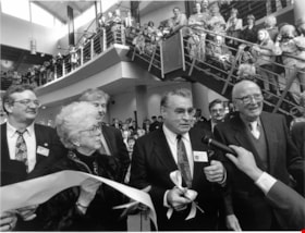
Interview with William J. Copeland by Rod Fowler February 18, 1990 - Track 4
https://search.heritageburnaby.ca/link/oralhistory438
- Repository
- City of Burnaby Archives
- Date Range
- 1927-1990
- Length
- 00:06:37
- Summary
- This portion of the interview is about Bill Copeland's childhood in Burnaby and Vancouver, his father's work as a miner, his war service, education, and his three children
- Repository
- City of Burnaby Archives
- Summary
- This portion of the interview is about Bill Copeland's childhood in Burnaby and Vancouver, his father's work as a miner, his war service, education, and his three children
- Date Range
- 1927-1990
- Photo Info
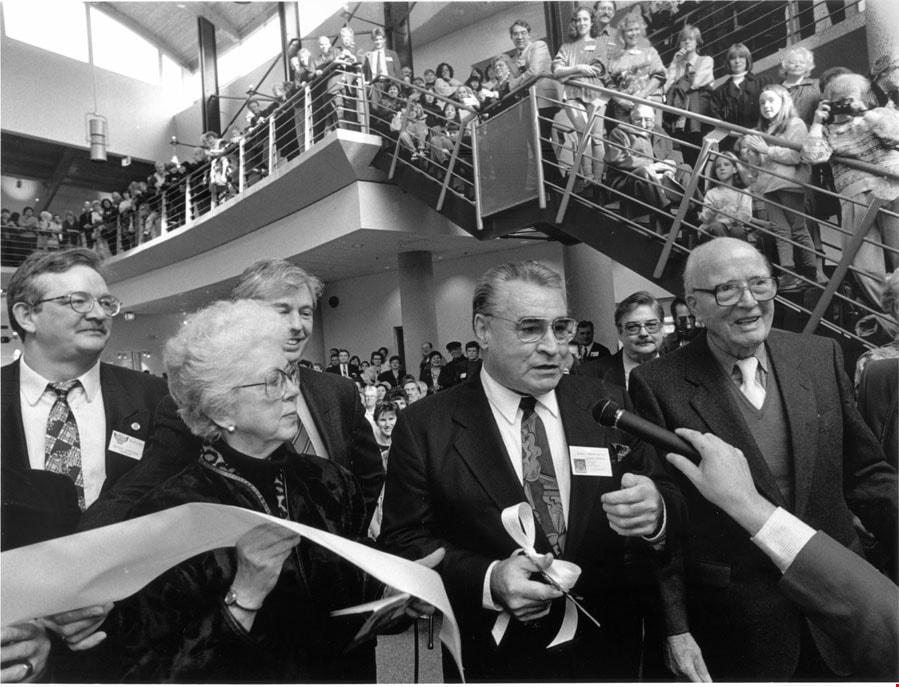
- Mayor Bill Copeland cutting the ribbon for the opening of the Shadbolt Centre for the Arts accompanied by Jack and Doris Shadbolt and Councillors Doug Drummond and Derek Corrigan, 1995. Item no. 535-0067
- Length
- 00:06:37
- Interviewer
- Fowler, Rod
- Interview Date
- February 18, 1990
- Scope and Content
- Recording is of an interview with former Burnaby Mayor William J. Copeland conducted by Rod Fowler. Bill Copeland was one of eleven participants interviewed as part of the SFU/Burnaby Centennial Committee's oral history series titled, "Voices of Burnaby". The interview is mainly about Bill Copeland’s education, career and experience as a Burnaby firefighter from 1955 to 1987, and his work for the union International Association of Fire Fighters. He talks about his early family life in Burnaby and Vancouver, war service, training with the Federal Fire Service, the organizations he has belonged to, and the careers of his three children. He briefly talks about Burnaby politics and his unexpected election to Mayor of Burnaby. Major themes of the interview, described by track: Track 1: Organizations - Unions; Public Services - Fire Protection; International Association of Fire Fighters; Track 2: Public Services - Fire Protection; Track 3: Elections; Track 4: family history and education; Track 5: Public Services - Fire Protection; Track 6: Elections
- Biographical Notes
- William John (Bill) Copeland (1927-2002) was born in Vancouver May 19, 1927. As a young child he lived with his parents on Southwood Street in South Burnaby on a chicken ranch. Bill’s father was a miner and was often away from home. The family moved to Pioneer Mines at Bridge River for a few years and then moved back to Vancouver in 1941 when his father contracted silicosis. Bill served in the navy for about a year near the end of WWII, was in the Canadian Merchant Marine and worked as a pipe fitter, before beginning his career as a fire fighter. He trained with the Federal Fire Service and worked two years at the Wireless Station in Delta. In 1955 he started work as Fire Fighter No. 53 in Burnaby, retiring 33 years later in 1987. Most of his career was spent at the Control Station or Number 1 Firehall, first located at Wiilingdon and Hastings (now No.5 Station) and later on Sperling near Canada Way. Bill worked as a first aid instructor, eventually moving into the training office, and retired as assistant chief. In 1987, shortly after retiring, Bill was asked to run for Mayor for the Burnaby Citizens Association (BCA). Much to his surprise he won. He served with distinction for three terms (1987-1996). Bill, his wife Ruth, and their three children, Doug and Dan (both firefighters) and Emily (a teacher), lived in North Burnaby on Cliff Avenue, the family home for about 35 years. Bill was active in many organizations including the Cliff Avenue soccer organization, St. John Ambulance, Burnaby Red Cross, and CNIB, among others. He began representing firefighters locally in the International Association of Fire Fighters in the early 1960s, eventually becoming President of the provincial association and then Vice President of the 6th District representing Western Canada.
- Total Tracks
- 6
- Total Length
- 0:25:35
- Interviewee Name
- Copeland, William J
- Interviewer Bio
- Rod Fowler returned to university as a mature student in the 1980s after working about twenty years in the field of economics and business computerization in England, Europe and Western Canada. He graduated with a BA from SFU in both History and Sociology in 1987, his MA degree in Geography in 1989, and his PhD in Cultural Geography at SFU. He taught courses in Geography, Sociology, History and Canadian Studies at several Lower Mainland colleges, before becoming a full time member of the Geography Department at Kwantlen University College.
- Collection/Fonds
- SFU/Burnaby Centennial Committee fonds
- Transcript Available
- Transcript available
- Media Type
- Sound Recording
- Web Notes
- Interviews were digitized in 2015 allowing them to be accessible on Heritage Burnaby. The digitization project was initiated by the Community Heritage Commission with support from City of Burnaby Council.
Images
Audio Tracks
Track four of interview with William J. Copeland
Track four of interview with William J. Copeland
https://search.heritageburnaby.ca/media/hpo/_Data/_Archives_Oral_Histories/_Unrestricted/MSS187-013/MSS187-013_Track_4.mp3Introduction to inorganic chemistry
https://search.heritageburnaby.ca/link/museumlibrary3159
- Repository
- Burnaby Village Museum
- Author
- Smith, Alexander, 1865-1922
- Edition
- 3rd ed.
- Publication Date
- 1919
- c1905
- Call Number
- 546 SMI
- Repository
- Burnaby Village Museum
- Collection
- Special Collection
- Material Type
- Book
- Accession Code
- HV972.165.127
- Call Number
- 546 SMI
- Edition
- 3rd ed.
- Author
- Smith, Alexander, 1865-1922
- Place of Publication
- New York
- Publisher
- The Century Co.
- Publication Date
- 1919
- c1905
- Physical Description
- v-xiv; 925 p. : ill. ; 20 cm.
- Inscription
- inside, "T J M Roy Agassiz, B.C." "Arts '23" "U.B.C." "Sept. 1919" "1426 - 8th Ave. W. Vancouver, BC" crossed-out "W111"
- Library Subject (LOC)
- Chemistry, Inorganic
- Chemistry--Textbooks
- Notes
- Includes index.

Jacob & Margaret Wysong House
https://search.heritageburnaby.ca/link/landmark507
- Repository
- Burnaby Heritage Planning
- Description
- The Jacob and Margaret Wysong House is a two and one-half storey, wood-frame Arts and Crafts house with a hipped roof and hipped dormers. Symmetrical in massing, it is distinguished by its masonry verandah columns, foundations and chimneys. It is located on a corner lot on Sperling Avenue at Stanle…
- Associated Dates
- 1912
- Formal Recognition
- Heritage Designation, Community Heritage Register
- Street View URL
- Google Maps Street View
- Repository
- Burnaby Heritage Planning
- Geographic Access
- Sperling Avenue
- Associated Dates
- 1912
- Formal Recognition
- Heritage Designation, Community Heritage Register
- Enactment Type
- By-law No. 11978
- Enactment Date
- 17/10/2005
- Description
- The Jacob and Margaret Wysong House is a two and one-half storey, wood-frame Arts and Crafts house with a hipped roof and hipped dormers. Symmetrical in massing, it is distinguished by its masonry verandah columns, foundations and chimneys. It is located on a corner lot on Sperling Avenue at Stanley Street in the Edmonds neighbourhood of South Burnaby.
- Heritage Value
- The Jacob and Margaret Wysong House is significant for illustrating the early development of the Edmonds neighbourhood, a speculative subdivision that was created and marketed during the pre-First World War real estate boom. The area’s proximity to New Westminster, coupled with extensive views and two newly developed streetcar lines, ensured that Edmonds attracted a wave of suburban development. The scale of this house is atypical of the usual suburban lots, and reflects the prominence of this location and its spectacular views. Set on a large lot, the Jacob and Margaret Wysong House is a grand estate home that is one of the earliest, and most prominent, in South Burnaby. This is also an exceptional example of Arts and Crafts architecture, displaying the use of native materials that was a hallmark of the style. The first owners were Jacob Wysong and his wife Margaret. Jacob Wysong, a local contractor, constructed the house in 1912. The stonework is exceptional, and the use of rough-cut granite and fieldstone, with overall shingle cladding, recalls the rustic vernacular common in Western park lodges, and evokes a country lifestyle in harmony with nature. The hipped roof was designed with a flat top that acted as a lookout tower that provided views of the surrounding landscape.
- Defining Elements
- Key elements that define the heritage character of the Jacob and Margaret Wysong House include its: - prominent corner location in the Edmonds neighbourhood of South Burnaby - residential form, scale and massing as expressed by its two and one-half storey plus raised basement height, symmetrical plan, hipped roof with flat top, hipped dormers, and hipped roof over the full open front verandah with a central front gable - masonry elements such as rough-cut granite and fieldstone foundations, verandah columns, stair cheeks, and external and internal chimneys - wooden-frame construction including original cedar shingling on dormers and facing verandah, shingling on remainder of house under later stucco cladding, and surviving original dimensional trim facing verandah and on dormers - Arts and Crafts features such as the use of natural materials, open soffits and angled roof overhang - windows including: double-hung 18-over-1 wooden sash windows; multi-paned casement windows; French doors to verandah; and front door with glazed sidelights - associated landscape features including surrounding mature trees, hedges and perimeter plantings
- Historic Neighbourhood
- Edmonds (Historic Neighbourhood)
- Planning Study Area
- Kingsway-Beresford Area
- Function
- Primary Historic--Single Dwelling
- Primary Current--Single Dwelling
- Community
- Edmonds
- Cadastral Identifier
- P.I.D. 000-497-801
- Boundaries
- The Jacob and Margaret Wysong House is comprised of a single residential lot located at 6325 Sperling Avenue, Burnaby.
- Area
- 1087.62
- Contributing Resource
- Building
- Ownership
- Private
- Documentation
- City of Burnaby Planning and Building Department, Heritage Site Files
- Street Address
- 6325 Sperling Avenue
- Street View URL
- Google Maps Street View
Images


James & Harriet Atkey Residence
https://search.heritageburnaby.ca/link/landmark603
- Repository
- Burnaby Heritage Planning
- Description
- Residential building.
- Associated Dates
- 1913
- Street View URL
- Google Maps Street View
- Repository
- Burnaby Heritage Planning
- Geographic Access
- MacDonald Avenue North
- Associated Dates
- 1913
- Description
- Residential building.
- Heritage Value
- This Arts and Crafts residence has retained many of its original features, such as its full open front verandah with twinned square columns, shingle siding, and triangular eave brackets. Typical of the era, the front door has glazed insets and the living room window assembly has opening casements and transoms above. The second floor sleeping porch has retained its original arched openings. It has been restored and is in very good condition. It was built by C.A. Curseaden of Kerrisdale and sold to James William Atkey (1868-1956), a general store merchant, and his wife Harriet Ellen (née Bugg, 1868-1944) in 1915.
- Locality
- Vancouver Heights
- Historic Neighbourhood
- Vancouver Heights (Historic Neighbourhood)
- Planning Study Area
- Burnaby Heights Area
- Area
- 371.61
- Contributing Resource
- Building
- Ownership
- Private
- Street Address
- 20 Macdonald Avenue North
- Street View URL
- Google Maps Street View
Images


J.A. Thurston House 'Altese'
https://search.heritageburnaby.ca/link/landmark511
- Repository
- Burnaby Heritage Planning
- Description
- The J.A. Thurston House is a very large, two and one-half storey plus basement wood-frame Arts and Crafts style house. It is located on the south side of Thurston Street, near Kingsway and the SkyTrain (formerly the interurban tramline route), within the Metrotown area of Burnaby and is now part of…
- Associated Dates
- 1912
- Formal Recognition
- Heritage Designation, Community Heritage Register
- Other Names
- John A. & Sarah Thurston House
- Street View URL
- Google Maps Street View
- Repository
- Burnaby Heritage Planning
- Other Names
- John A. & Sarah Thurston House
- Geographic Access
- Thurston Street
- Associated Dates
- 1912
- Formal Recognition
- Heritage Designation, Community Heritage Register
- Enactment Type
- Bylaw No. 9934
- Enactment Date
- 09/08/1993
- Description
- The J.A. Thurston House is a very large, two and one-half storey plus basement wood-frame Arts and Crafts style house. It is located on the south side of Thurston Street, near Kingsway and the SkyTrain (formerly the interurban tramline route), within the Metrotown area of Burnaby and is now part of a large apartment complex.
- Heritage Value
- The J.A. Thurston House demonstrates Burnaby's real estate and construction boom along the interurban tramline in 1911. The house was built for John Albert Thurston (1874-1944) and his wife Sarah Sedona Thurston (1879-1961). Typical of the entrepreneurial spirit of the age, John Thurston, a manager for the Leckie Shoe Company Limited in Vancouver, was also involved in real estate development, and purchased a twenty-one lot subdivision consisting of 3.2 hectares bound by the interurban tramline right-of-way to the south, Boundary Road to the west and Smith Street (now Thurston Street) to the north. Additionally, the J.A. Thurston House is an excellent, high quality example of an Arts and Crafts style dwelling, with numerous notable design elements such as the battered piers, the elaborate second storey dormer and stained glass windows with landscape and seascape motifs. The enormous scale of the house reflects a time when large families were common and domestic servants were needed to run the household. Indicative of the labour-saving devices and luxury features being introduced at the high end of the housing market, it was equipped with a built-in vacuum system, refrigeration, servant summoning devices and a round safe built into a fireplace mantle. The J.A. Thurston House also represents the proliferation during the Edwardian era of homes built from pattern books and standardized designs as a means to expedite the construction process and offer competitive costs.
- Defining Elements
- Key elements that define the heritage character of the J.A. Thurston House include its: - location on Thurston Street, in the old Central Park district - residential form, scale and massing as exemplified by its two and one-half storey plus above-ground basement height and regular, rectangular plan - Arts and Crafts style details such as the picturesque roofline, deep open eaves with exposed purlins, narrow lapped wooden siding on the first storey and cedar shingle siding on the upper storeys - broad and unusually steep side gabled roof, clad with cedar shingles - deeply-recessed full open front verandah with complementary recessed balcony in second storey dormer, incorporating both a gabled roof and shed roof - twinned and triple square bracketed columns on the verandahs and balcony - decorative battered verandah piers, supported on exposed beams - irregular fenestration, including: double-hung wooden-sash windows; picture windows; casement windows; and several stained glass windows with landscape and seascape motifs - tall brick external chimney on east facade - original interior features such as fireplaces, and wooden trim and floors
- Historic Neighbourhood
- Central Park (Historic Neighbourhood)
- Planning Study Area
- Garden Village Area
- Function
- Primary Historic--Single Dwelling
- Primary Current--Single Dwelling
- Community
- Burnaby
- Cadastral Identifier
- 018-224-113
- Boundaries
- The J.A. Thurston House is comprised of a single residential lot located at 3762 Thurston Street, Burnaby.
- Area
- 3880
- Contributing Resource
- Building
- Ownership
- Private
- Street Address
- 3762 Thurston Street
- Street View URL
- Google Maps Street View
Images


J.D. Shearer House
https://search.heritageburnaby.ca/link/landmark513
- Repository
- Burnaby Heritage Planning
- Description
- The J.D. Shearer House is a one and one-half storey British Arts and Crafts-style house distinguished by its picturesque roofline, half-timbered rough-cast stucco cladding on the upper floor and battered window casings. It is located on the south side of Buckingham Avenue at Haszard Street in Burna…
- Associated Dates
- 1912
- Formal Recognition
- Heritage Designation, Community Heritage Register
- Other Names
- John D. & Katherine Shearer House
- Street View URL
- Google Maps Street View
- Repository
- Burnaby Heritage Planning
- Other Names
- John D. & Katherine Shearer House
- Geographic Access
- Buckingham Avenue
- Associated Dates
- 1912
- Formal Recognition
- Heritage Designation, Community Heritage Register
- Enactment Type
- Bylaw No. 10423
- Enactment Date
- 26/08/1996
- Description
- The J.D. Shearer House is a one and one-half storey British Arts and Crafts-style house distinguished by its picturesque roofline, half-timbered rough-cast stucco cladding on the upper floor and battered window casings. It is located on the south side of Buckingham Avenue at Haszard Street in Burnaby's Deer Lake neighbourhood.
- Heritage Value
- Built in 1912, the J.D. Shearer House is an excellent example of the high quality residences constructed in the British Arts and Crafts style by affluent citizens in Burnaby's Deer Lake neighbourhood, promoted at the time as the equivalent of the prestigious Shaughnessy Heights development in Vancouver. The site of this house was part of Louis Claude Hill's Buckingham Estate subdivision. Development of these Edwardian era neighbourhoods in Burnaby was facilitated by the B.C. Electric Railway interurban line. In addition, the increasing availability of automobiles to the well-to-do families of the era sped up the process of urbanization in the outlying areas of Vancouver. Built for retired English military officer John D. Shearer and his wife, Katherine, the British Arts and Crafts design of the house represents associations with the Mother Country and the displays of patriotic loyalty considered desirable characteristics at the time. The picturesque charm and character of rural England is evoked in harmony with its woodland setting.
- Defining Elements
- Key elements that define the heritage character of the J.D. Shearer House include its: - location in the Buckingham Estate subdivision in the Deer Lake neighbourhood - residential form, scale and massing as exemplified by its one and one-half storey plus basement height, asymmetrical plan, front bay window and picturesque roofline - British Arts and Crafts details such as the half-timbering and rough-cast stucco on the upper storey, battered window casings, external clinker brick chimney on the east facade, deep overhanging closed eaves and bargeboards with distinctive lower returns - side gabled roof with gabled and shed dormers, clad in cedar - raised central entrance porch - irregular fenestration, including multi-paned transoms over casement windows - two internal red brick chimneys
- Historic Neighbourhood
- Burnaby Lake (Historic Neighbourhood)
- Planning Study Area
- Morley-Buckingham Area
- Function
- Primary Historic--Single Dwelling
- Primary Current--Single Dwelling
- Community
- Burnaby
- Cadastral Identifier
- 023-316-977
- Boundaries
- The J.D. Shearer House is comprised of a single residential lot located at 5573 Buckingham Avenue, Burnaby.
- Area
- 1044
- Contributing Resource
- Building
- Ownership
- Private
- Street Address
- 5573 Buckingham Avenue
- Street View URL
- Google Maps Street View
Images

Jesse Love farmhouse series
https://search.heritageburnaby.ca/link/museumdescription9782
- Repository
- Burnaby Village Museum
- Date
- [1893-1970] (date of originals), copied 1988-1998, predominant 1988-2000
- Collection/Fonds
- Burnaby Village Museum fonds
- Description Level
- Series
- Physical Description
- approx. 84 cm of textual records + approx. 1,910 photographs + approx. 100 architectural drawings + 3 audio cassettes + 1 videocassette
- Scope and Content
- Series consists of records involved in the purchase, moving, restoration, research, conservation and exhibiting of the Love family farmhouse by Burnaby Village Museum. Records have been arranged into the following subseries: 1) Love farmhouse conservation work files subseries 2) Love farmhouse re…
- Repository
- Burnaby Village Museum
- Collection/Fonds
- Burnaby Village Museum fonds
- Series
- Jesse Love farmhouse series
- Description Level
- Series
- Physical Description
- approx. 84 cm of textual records + approx. 1,910 photographs + approx. 100 architectural drawings + 3 audio cassettes + 1 videocassette
- Scope and Content
- Series consists of records involved in the purchase, moving, restoration, research, conservation and exhibiting of the Love family farmhouse by Burnaby Village Museum. Records have been arranged into the following subseries: 1) Love farmhouse conservation work files subseries 2) Love farmhouse restoration photographs subseries 3) Love farmhouse curatorial files subseries 4) Love farmouse research files subseries 5) Love family photographs 6) Love farmhouse Oral History subseries 7) Love farmhouse architectural drawings subseries
- History
- Jesse Love was born in Swindon, England in 1847 and left England to work on a dairy farm in the Toronto area. While working on the farm in Toronto, he met Martha Leonard who he married in 1879. Martha was born on February 3, 1858 in Bedfordshire, England and had come to Canada with her parents George and Ann Leonard. While living in Toronto, Jesse and Martha had two children, George born March 22, 1880 and Annie Elizabeth on August 24, 1881. About one year after Annie was born, the Love family moved to North Dakota to grow wheat. While living there, they had two more children, Henry who was born August 24, 1883 and Edith Minnie born October 9, 1885. The family decided to move further west after hearing about the fairer weather conditions from Martha’s father, George Leonard, who had settled in Vancouver in 1885. On May 23, 1887, Jesse, Martha and their four children arrived in Vancouver after travelling across Canada from Winnipeg on the first transcontinental train. The Loves made their home in Vancouver while Jesse helped clear land on Granville Street. Their fifth child, Thomas Robert was born on September 17, 1887 and soon after, the family moved to Lulu Island in Richmond where they lived growing vegetables and selling them to Vancouver hotels. While living and farming on Lulu island, the couple had two more girls, Martha (Dot or Dorothy) born on December 17, 1889 and Sarah Marie, born February 8, 1892. On October 6, 1893 an agreement was signed by Jesse Love to purchase 14.52 acres of land from Joseph C. Armstrong. The acreage covered the north east section of District Lot 25 within the newly incorporated District of the Municipality of Burnaby. It was here where the original Love house was built (between October 1893 and April 15, 1894) by Jesse Love with the help of local builder George Salt and father in law, George Leonard. The house consisted of an entrance hall, dining room, lean to kitchen, master bedroom and three bedrooms upstairs. A road was constructed and named Cumberland in 1905 and ran from District Lot 25 through to District Lot 11. The address for the Love home was 1390 Cumberland Road and in the early 1960’s the address was renumbered 7651 Cumberland Street. On the land surrounding the house, Jesse Love planted an orchard along with strawberries and raspberries which he sold at the Fraser Valley Market, T.S. Anandale’s Grocery Store in New Westminster and to hotels around Vancouver. Jesse Love served on the Burnaby School Board and also as a District Councillor in 1901 and from 1904-1907. While living in the house, Jesse and Martha had four more children, Phoebe Leonard, born April 15, 1894, Esther, born August 28, 1896, John Leonard, born June 7, 1899 and Hannah Victoria (also known as Girlie) who was born May 12, 1902. As the family grew to eleven children, additions along with some substantial remodelling in the craftsman style took place. In about 1898, a north wing addition was added to include a parlour with two windows, the construction of two more bedrooms and the relocation of the stair case to the North West wall. In 1903 the front door moved to the north elevation, a front porch was extended along the east wall and a summer lean to kitchen was added to the west elevation. Between 1905 and 1910, a tin embossed ceiling was installed along with an addition of the main kitchen which included a pantry, bathtub and a back porch. In about 1912, five craftsman style windows replaced the original pioneer tent style, the front verandah was enlarged to wrap around the south and east elevations, a back door was installed in the kitchen to access the verandah and wood shingle siding and brackets were added to the exterior. In 1918, at the age of 31 years, Robert Love fell ill due to an influenza epidemic and died on November 23, 1918. Following their son’s death, Martha Love became weak and on August 24, 1920, she passed away. By this time, Jesse had sold off a large percentage of his land and his youngest daughter, Girlie decided to stay on to live and care for him. Since the house was too large for just the two of them, Jesse invited any other children to return and share the residence. For a while his son, George and his wife joined them until 1925, followed by his daughter Sarah Parker (nee Love), her husband William and their three children, Albert, Bill and Elsie. The house remained pretty unchanged until 1928 after Jesse Love died of pneumonia (March 10, 1928) and the house was purchased by Sarah and her husband William Parker who continued to live there with their children. The master bedroom wall on the main floor opened up to the dining room, the kitchen pantry and bathtub converted to an alcove with a marble counter and enlarged window and sink while the bathroom was moved to the upstairs and the furnace and coolers were installed in the crawl space under the kitchen. A hot water tank was installed in the house in 1966. Sarah continued to live in the house until a little while after her husband William died in 1961. She sold the house to her daughter Elsie and husband John Hughes in 1966, who lived in the house along with their son Brent, until August 23, 1971. Mahbir Molchan Papan and his wife Geraldine Papan bought the house August 23, 1971 and by 1982, the house was sold to Nirmal Singh Singha and Narinder Singha. The Papans continued to rent the house from Nirmal Singh Singha and Narinder Singha until the late 1980s. In 1988, the house was scheduled for demolition with the remaining property to be subdivided. Fortunately, a neighbour, Mr. Harvey Elder recognized the farmhouse's historical significance and contacted the Burnaby Historical Society. Following this event, the owners agreed to donate the building to the Burnaby Village Museum (under the Century Park Museum Association) who financed the move of the house from Cumberland Street to the museum site. Heritage planner and architect, Robert Lemon provided guidance for the project. Prior to the move, the two porches were removed and demolished while the kitchen and roof were both separated from the main house. The kitchen and roof of the house were transported to Burnaby Village Museum on May 20, 1988 by Nickel Bros. House Moving company, while the main frame of the house completed its transportation to the museum near the end of May 1988 (due to low overhead wires). The house was moved down Cumberland Street to 10th Avenue, up Canada Way to Sperling and set on temporary footings near Hart House. Robert Lemon oversaw structural improvements such as, upgrading floor joists and creating new foundations to replace the original timber foundation of the farmhouse. The restoration went through several phases of work between 1988 until it opened in November 1998. Restoration began on both the interior and exterior features to be interpreted from the period of 1925. On November 23, 1992, the building was designated a heritage building under Heritage Designation Bylaw 1992, Bylaw Number 9807. In 1993, the architecture firm of Brian G. Hart Associates was appointed for the design and construction supervision of the restoration project. Plans were created for a foundation on the museum site in 1989 and the farmhouse was eventually settled on a permanent foundation behind the Burnaby Village Museum administration building in 1993 along with the reattachment of the roof. The kitchen section was reattached to the main house in 1994 along with skirting around the foundation and the reshingling of the exterior. In 1996, the tin ceiling was removed to make way for the installation of the internal electrical system along with sprinklers, ceiling heating and fire break gyprock. The dining room ceiling joists were consolidated, a pantry and bathroom were added to the kitchen, the downstairs bedroom wall was opened and filled, the dining and kitchen doorways were widened. In 1997, a wheelchair ramp was installed along with a concrete sidewalk, stair rails, cement pads at the base of the stairs and a gravel sink for any excess water. Interior work included painting of the kitchen, restoration and furnishing of the kitchen pantry, insulation of the house floor to protect from rodents along with the reconstruction of the kitchen and house chimneys. The registrar worked together with the curator and conservator and was tasked with a large research project on the house including the family contacts and family history, property information, plans, photographs, artifacts, furnishings, stories etc. all organized in files for easy retrieval. A great deal of research and conservation was undertaken in order to make the interior of the house authentic to the time period as possible. One of the biggest projects was selecting and obtaining wall coverings since much of the original wallpaper was incomplete and poor condition. The conservator and registrar were lucky enough to locate a few samples of the original paper and engage the Bradbury and Bradbury Art Wallpaper Company of Benica, California to reproduce replica designs for free. The City of Burnaby now has its own series “Burnaby Village Papers” produced by this company which are titled “Burnaby Wall”; “Burnaby Border” and “Burnaby Ceiling”. All three of these wallpaper designs have been used in the Love farm house and are also commercially available through the Bradbury and Bradbury Art Wallpaper Company. In 1997, restoration of the kitchen was completed and opened to the public. After the completion of the dining room, main floor bedroom and parlour, the Love farmhouse exhibit opened on November 29, 1998 with an open invitation to the public and extended members of the Love family. Officials including the Mayor, Doug Drummond and Love family members were all present to cut the ribbon for the special event.
- Accession Code
- BV018.41; BV020.5
- Access Restriction
- Restricted access
- Date
- [1893-1970] (date of originals), copied 1988-1998, predominant 1988-2000
- Arrangement
- The majority of the records within series and subseries were arranged by a staff members of Burnaby Village Museum who worked on the historical research and restoration of the house. Other photographs documenting the move and further restoration work were added later and included in the arrangment by format and subject.
- Notes
- Title based on content of series
- Jesse Love farmhouse is described as an Artifact under BV988.33.1
- Some records within this collection have restricted access and are subject to FIPPA
- Accessions BV018.41 and BV020.5 form this fonds

J.R. & Frances Dawson Residence
https://search.heritageburnaby.ca/link/landmark599
- Repository
- Burnaby Heritage Planning
- Description
- Residential building.
- Associated Dates
- c.1912
- Street View URL
- Google Maps Street View
- Repository
- Burnaby Heritage Planning
- Geographic Access
- Cambridge Street
- Associated Dates
- c.1912
- Description
- Residential building.
- Heritage Value
- This beautifully-detailed house displays a highly sophisticated mix of fashionable Arts and Crafts elements. The asymmetrical design has stacked inset verandahs on one side, with the ground floor verandah wrapping around the side of the house. The second floor verandah has an arched opening, supported by short versions of the ground floor columns and accessed by French doors with geometric patterned, multi-paned glazing. A semi-circular lunette window lights the attic, and banked windows with leaded transoms are used on the front façade. Decorative details include triangular eave brackets and square verandah columns with distinctive bracketted capitals. The house has survived in original condition except for a later asbestos siding that was applied over the original shingle siding, and the enclosure of the side verandah. The home was owned by J.R. Dawson and Frances Abigail Dawson (née Thompson, 1853-1938) from 1915 until Frances’ death in 1938.
- Locality
- Vancouver Heights
- Historic Neighbourhood
- Vancouver Heights (Historic Neighbourhood)
- Planning Study Area
- Burnaby Heights Area
- Area
- 566.71
- Contributing Resource
- Building
- Ownership
- Private
- Street Address
- 3746 Cambridge Street
- Street View URL
- Google Maps Street View
Images

Junior printing
https://search.heritageburnaby.ca/link/museumlibrary6643
- Repository
- Burnaby Village Museum
- Collection
- Reference Collection
- Material Type
- Book
- Call Number
- 686.2 LUS
- Place of Publication
- Peoria, Ill.
- Publisher
- Manual Arts Press
- Publication Date
- c1943
- Physical Description
- 64 p. : ill. : 27 cm.
- Library Subject (LOC)
- Printing
- Notes
- Includes bibliographical references (listed throught out the book)
- Author's full name : Clifford, Keith Lush

Kingsway East School
https://search.heritageburnaby.ca/link/landmark546
- Repository
- Burnaby Heritage Planning
- Description
- The Kingsway East School is a two-storey wood-frame Arts and Crafts styled building. The school, and the adjacent cenotaph and memorial tennis courts, comprise Burnaby South Memorial Park.
- Associated Dates
- 1913
- Formal Recognition
- Heritage Designation, Community Heritage Register
- Other Names
- Alan Emmott Centre
- Street View URL
- Google Maps Street View
- Repository
- Burnaby Heritage Planning
- Other Names
- Alan Emmott Centre
- Geographic Access
- Southoaks Crescent
- Associated Dates
- 1913
- Formal Recognition
- Heritage Designation, Community Heritage Register
- Enactment Type
- Bylaw No. 9807
- Enactment Date
- 23/11/1992
- Description
- The Kingsway East School is a two-storey wood-frame Arts and Crafts styled building. The school, and the adjacent cenotaph and memorial tennis courts, comprise Burnaby South Memorial Park.
- Heritage Value
- This school structure completed in 1913, the oldest surviving public education building in the city, was intended to be the auditorium and gymnasium for Burnaby’s first high school. However, because of the 1913 recession and the outbreak of the First World War, it was utilized as the Kingsway East Elementary School for the Edmonds District until 1921. Burnaby South High School opened here in 1922, and after it relocated this building was used for a variety of school purposes until it became redundant. The school was rehabilitated for community purposes in 2002-03 and renamed the Alan Emmott Centre to honor a former Mayor of Burnaby. The impressive scale of the Kingsway East School is indicative of the relative size of the community and its growing demand for schooling at the time of construction, illustrating the value that early community residents placed on education. Built to plans of the Burnaby School Board architect, Joseph Henry Bowman (1864-1943), it also indicates the individual values and design control exercised by the school board during this era. It is also significant for its Arts and Crafts style, allied to the typical Craftsman residential vocabulary, which was employed locally for school buildings of the Edwardian era. By using a common architectural vocabulary, this allowed the institution to reflect the values and aspirations of the local community. The Arts and Crafts style also demonstrated an allegiance to British educational antecedents and a demonstration of loyalty to the Mother Country.
- Historic Neighbourhood
- Edmonds (Historic Neighbourhood)
- Planning Study Area
- Kingsway-Beresford Area
- Function
- Primary Historic--Primary School
- Community
- Burnaby
- Cadastral Identifier
- P.I.D. No. 016-367-154 Legal Description: Lot 1, District Lot 96, Group 1 New Westminster District, Plan 86581
- Boundaries
- The Kingsway East School is comprised of a single municipally-owned property located at 6650 Southoaks Crescent, Burnaby.
- Area
- 6,070.00
- Contributing Resource
- Building
- Landscape Feature
- Structure
- Ownership
- Public (local)
- Documentation
- Heritage Site Files: PC77000 20. City of Burnaby Planning and Building Department, 4949 Canada Way, Burnaby, B.C., V5G 1M2
- Street Address
- 6650 Southoaks Crescent
- Street View URL
- Google Maps Street View
Images


Laurence J. Peter family fonds
https://search.heritageburnaby.ca/link/archivedescription88409
- Repository
- City of Burnaby Archives
- Date
- 1949
- Collection/Fonds
- Laurence J. Peter family fonds
- Description Level
- Fonds
- Physical Description
- 1 p. of textual records.
- Scope and Content
- Fonds consists of one Share Certificate for the Lochdale Co Operative Association.
- Repository
- City of Burnaby Archives
- Date
- 1949
- Collection/Fonds
- Laurence J. Peter family fonds
- Physical Description
- 1 p. of textual records.
- Description Level
- Fonds
- Access Restriction
- In Archives only
- Accession Number
- 2013-29
- Scope and Content
- Fonds consists of one Share Certificate for the Lochdale Co Operative Association.
- History
- In 1941, Laurence J. Peter began his career as an industrial arts teacher at Lord Tweedsmeer High School in Cloverdale, after an illness kept him out of World War II. It was here that he met his future wife, Nancy M. Bailey, who was the vice principal of the school. The couple married in 1943 and made their way to Burnaby in 1947 after purchasing a one-acre lot in Burnaby from Mr. Wright for $1,000. When the couple purchased this lot, Nancy was teaching English at Burnaby South High School, while Laurence was teaching Woodwork at New Haven Borstal Home for Boys in the Provincial Corrections system. The lot was located in the historic neighbourhood of Lozell’s at 7229 Lougheed Highway and was renumbered to 7449 Lougheed in 1958. Laurence and Nancy had four children, two boys (John and Ted) and two girls (Alice and Margaret). When they first purchased the lot, they built a small house where they lived with their eldest son, John, until the completion of a larger house in 1949. Their second son, Ted, was born a few weeks before the completion of the larger house and was brought into the new home from the hospital. Their daughters were born over the next few years. Laurence and Nancy had built the larger house using a technique of peeled plywood core logs. Laurence and his cousin, Hewton Peter, who owned the lot next door, designed and built a machine to build exterior walls for their houses using plywood cores. In 1947, plywood cores were turned (peeled) down to six inches in diameter and then discarded to be chipped for the pulp industry. To build the house, the cores were splined together and stood on end making a vertical log house. Only three houses were ever built using their invention. The three-bedroom, one-bathroom house was completed in October 1949. The exterior of the house was never painted, just brushed with linseed oil. The traffic of the Lougheed Highway was not heard inside the house due to the six-inch walls and was very economical to heat in the snowy winters of the 1950s. Over the years, the couple worked on finishing the interior of the house, which included an intricately carved eight-foot-wide oak mantelpiece carved by Laurence. Parts of the mantel were reclaimed from the demolished old Hotel Vancouver and cobblestones reclaimed from the interurban tracks were used for the fireplace and stonework around the property. The family raised goats for milk and chickens for eggs and maintained a large vegetable garden and fruit trees on the property. When the goats and chickens were not needed anymore, Laurence slaughtered them for meat which they stored in a freezer at the Lochdale Co-operative until they were ready to consume them. The family was actively involved in the Burnaby community with Laurence and Nancy taking part in local politics and community activities and their children participating in Boy Scouts and Girl Guides and music lessons. All four children graduated from Burnaby North High School, and in 1970, Ted and Alice completed their studies at British Columbia Institute of Technology (BCIT). They worked at local jobs in the community, including building the Burnaby Mountain Golf Course. Laurence moved on to take a position as a Mental Health Coordinator (Special Counselor) in the Vancouver School System, and in 1959, Nancy joined the staff at the newly opened Burnaby Central Senior Secondary School as a math teacher, later becoming the head of the Mathematics Department. The couple continued their education at summer school at Washington State University in Pullman, Washington, where Nancy completed her Master's Degree in 1964 and Laurence his Doctoral degree in 1963. Laurence joined the faculty of the University of British Columbia in 1965 and later received the WSU Regents’ Distinguished Alumnus Award in 1980. The couple separated in 1965 and Laurence moved to California in 1966 to teach at the University of Southern California. Laurence became widely famous in 1969, after the publication of his bestselling book, "The Peter Principle," which has been translated into more than 38 languages. Following this publication, he went on to author eight more books and published several texts in the field of ‘Prescriptive Teaching’. He died on January 12, 1990, at the age of 70 at his home in Palos Verdes Estates, California, and is honoured with a plaque as part of the Literary Landmarks program of the Vancouver Public Library located at the Metro Theatre, 1370 Marine Drive. Nancy continued to teach at Burnaby South, until her retirement in 1978 after 30 years as head of the Mathematics Department at Burnaby Central. She was an active member of the Burnaby Historical Society for many years. She passed away in Nanaimo near her family on April 21, 2013, at the age of 97.
- Media Type
- Textual Record
- Creator
- Peter, Laurence J.
- Notes
- Title based on contents of fonds
- MSS186-001
Le Cid : tragedie par Corneille
https://search.heritageburnaby.ca/link/museumlibrary3161
- Repository
- Burnaby Village Museum
- Author
- Corneille, Pierre, 1606-1684
- Publication Date
- 1918
- Call Number
- 842.41 COR
- Repository
- Burnaby Village Museum
- Collection
- Special Collection
- Material Type
- Book
- Accession Code
- HV972.165.129
- Call Number
- 842.41 COR
- Author
- Corneille, Pierre, 1606-1684
- Contributor
- Marks, J. (Joseph), -1964
- Place of Publication
- Manchester
- Publisher
- Manchester University Press
- Publication Date
- 1918
- Series
- French series for schools
- Printer
- R. & R. Clark, Ltd.
- Physical Description
- lxxxiv, 152, [4] p. : 19 cm.
- Inscription
- inner front cover: "W 113" [written in pencil, crossed out] inner front page: "1.10" [written in pencil] inner front page: "F.J. McRae Arts '23" [handwritten in ink] "1426 - 8th Ave W. Vancouver B.C." handwritten notes inside the text
- Library Subject (LOC)
- El Cid, Ca. 1043-1099--Drama
- Notes
- Text in French, introduction and notes in English.
- Includes index and bibliographic references.
- Marks, Joseph editor.
Leila Orman subseries
https://search.heritageburnaby.ca/link/archivedescription62945
- Repository
- City of Burnaby Archives
- Date
- 1918-1976
- Collection/Fonds
- Burnaby Historical Society fonds
- Description Level
- Subseries
- Physical Description
- Textual records and other materials
- Scope and Content
- Subseries consists of manuscripts written by Leila Orman as well as paintings, scrapbooks, postcards, photographs, hymn books and correspondence.
- Repository
- City of Burnaby Archives
- Date
- 1918-1976
- Collection/Fonds
- Burnaby Historical Society fonds
- Subseries
- Leila Orman subseries
- Physical Description
- Textual records and other materials
- Description Level
- Subseries
- Accession Number
- BHS2007-04
- Scope and Content
- Subseries consists of manuscripts written by Leila Orman as well as paintings, scrapbooks, postcards, photographs, hymn books and correspondence.
- History
- A. Leila Orman was born June 2, 1901 in Eastleigh, Hampshire, England. She is the youngest daughter of Daisy Marie Orman, her sister Daisy Hilda Orman (later Targett) being three and a half years her senior. At five years old Leila began a long fight with a crippling type of rheumatoid arthritis. By the time she was thirteen, she experienced completely ankylosed joints. Her family travelled all over hoping to find a cure, but to no avail. In 1913 her father joined his two brothers in Calgary, and by 1915 the family had joined him. Leila developed an interest in painting and knitting, and composed her own poems. She began writing news articles for the Calgary Daily Herald in the 1930s, and her first sonnet was published in that paper on August 28, 1934. She had a strong interest in the arts, often writing about music and the visual arts. While living in Calgary, she became a member of the Business and Professional Women’s Club as well as a member of the Canadian Author’s Association. When her father retired in 1938, the family moved to Rosewood Avenue in Burnaby. Leila wrote on a typewriter with two sticks to type out the letters. She was an avid reader and was able to turn the pages with a special stick with elastic bands wound around the ends. Canadian novelist Maida Parlow French became her lifelong friend and encouraged her to write her own autobiography, but she was not able to finish it. Leila wrote “The Giving Heart” in October of 1948. By 1952, she was writing the "Across the Board" column for the British Columbia Saturday Magazine with the intention of inspiring other “incapacitated folk” to live up to their full potential: “If [she] could reach a few people, and encourage them to reach up and out, [she] should feel the effort well worthwhile.” A member of the St. Alban’s Prayer Healing Fellowship group, Leila wrote the “Christian Manifesto for World Peace” in 1963. The Prayer Group met twice monthly at one of the members’ homes and undertook to pray daily for the sick and for world peace. After Leila’s mother died in 1955, Leila’s friend Jeanie Brown kept house for her and was her constant companion. Jeanie Brown and Leila lived together for over thirteen years until an accident sent Leila to hospital and later to nursing home where she died on February 16, 1976.
- Media Type
- Textual Record
- Photograph
- Creator
- Orman, A. Leila
- Notes
- MSS104 and PC506
- Title based on content of subseries

Moore House
https://search.heritageburnaby.ca/link/landmark497
- Repository
- Burnaby Heritage Planning
- Description
- The Moore House is a one-storey, side-gabled house with stepped roof planes and a split-level attached garage. The house faces east, and features distinct river rock porch columns and a large central tapered chimney. It is located within the Deer Lake Park Heritage Precinct, and is adjacent to a re…
- Associated Dates
- 1941
- Formal Recognition
- Community Heritage Register
- Other Names
- Ethel Moore Residence
- Street View URL
- Google Maps Street View
- Repository
- Burnaby Heritage Planning
- Other Names
- Ethel Moore Residence
- Geographic Access
- Sperling Avenue
- Associated Dates
- 1941
- Formal Recognition
- Community Heritage Register
- Enactment Type
- Council Resolution
- Enactment Date
- 26/05/2003
- Description
- The Moore House is a one-storey, side-gabled house with stepped roof planes and a split-level attached garage. The house faces east, and features distinct river rock porch columns and a large central tapered chimney. It is located within the Deer Lake Park Heritage Precinct, and is adjacent to a related house, the Rosalie (Moore) Barrett Residence, built the following year.
- Heritage Value
- The Moore House is significant for its relationship to first owner, Ethel Hutchings Moore (1884-1948), who purchased the property from Maud and Harriet Woodward, two of Deer Lake's first residents. Moore purchased the property with the hopes of introducing her children into the house construction business. This house, built in 1941, borrows its design from a 'California Desert House' built in Carmel a few years earlier. Rendered in traditional materials, this modern style merges comfortably with the rustic British Arts and Crafts tradition of most Deer Lake houses. Unusual for being built during wartime date, it was built at a time when domestic construction was severely curtailed due to shortages of labour and material. It is now owned by the City of Burnaby and is part of the Deer Lake Park Heritage Precinct. The Moore House is significant as a testament to Deer Lake's continued popularity as a residential neighbourhood in the 1940s. Although Burnaby was serviced by a number of transportation links at the time, the increasing availability of automobiles provided improved access to outlying suburbs. Rising real estate prices in Vancouver and New Westminster attracted residents to this neighbourhood because of its relative affordability, central location and beautiful scenery.
- Defining Elements
- Key elements that define the heritage character of the Moore House include its: - location within the Deer Lake Park Heritage Precinct - residential form, scale and massing as expressed by its one-storey height, linear plan, side gabled roof with multiple roof planes and split-level attached garage - wood-frame construction with stucco cladding - river rock porch columns and external tapered chimney - decorative embellishments including scroll-cut stickwork on the rear elevation and waney-edged boards in the gable peaks - wooden-sash casement windows with three-part, horizontal leading - associated landscaping features, including stone wall at the front of the property and coniferous and deciduous trees surrounding the property
- Historic Neighbourhood
- Burnaby Lake (Historic Neighbourhood)
- Planning Study Area
- Morley-Buckingham Area
- Function
- Primary Historic--Single Dwelling
- Primary Current--Single Dwelling
- Community
- Deer Lake
- Cadastral Identifier
- P.I.D. 011-454-521
- Boundaries
- The Moore House is comprised of a single residential lot located at 5145 Sperling Avenue, Burnaby.
- Area
- 993.39
- Contributing Resource
- Building
- Ownership
- Public (local)
- Documentation
- City of Burnaby Planning and Building Department, Heritage Site Files
- Street Address
- 5145 Sperling Avenue
- Street View URL
- Google Maps Street View
Images


Museum and Art Notes - The Art, Historical, and Scientific Association of Vancouver
https://search.heritageburnaby.ca/link/archivedescription8853
- Repository
- City of Burnaby Archives
- Date
- 1949
- Collection/Fonds
- Planning Department fonds
- Description Level
- Item
- Physical Description
- Textual record
- Scope and Content
- Pamphlet includes historical information about Burnaby.
- Repository
- City of Burnaby Archives
- Date
- 1949
- Collection/Fonds
- Planning Department fonds
- Series
- Planning General series
- Physical Description
- Textual record
- Description Level
- Item
- Record No.
- 11814
- Accession Number
- 2001-02
- Scope and Content
- Pamphlet includes historical information about Burnaby.
- Media Type
- Textual Record
Nuttall's standard dictionary of the English language : based on the labours of the most eminent lexicographers
https://search.heritageburnaby.ca/link/museumlibrary388
- Repository
- Burnaby Village Museum
- Collection
- Special Collection
- Material Type
- Book
- Accession Code
- BV989.35.16
- Call Number
- 423 NUT
- Edition
- New ed.
- Place of Publication
- London
- Publisher
- Frederick Warne and Co.
- Publication Date
- 1911
- Printer
- Ballantyne, Hanson & Co.
- Physical Description
- vii-x, 816 p. : ill. ; 20 cm.
- Inscription
- inside front page: "Teo Y Pratt [handwritten in pencil] Bradner BC"
- Library Subject (LOC)
- English language--Dictionaries
- English language
- Notes
- "Based on the labours of the most eminent lexicographers". :
- "New and greatly enlarged edition comprising many thousands of new words which modern literature, science, and art have called into existence and common usage with pronunciations, etymologies, definitions, appendices of proper names, illustrations, etc., etc."
- "Revised, extended and improved throughout by the Rev. James Wood".
Parks, Recreation and Cultural Services Department fonds
https://search.heritageburnaby.ca/link/archivedescription97
- Repository
- City of Burnaby Archives
- Date
- 1920-1990
- Collection/Fonds
- Parks, Recreation and Cultural Services Department fonds
- Description Level
- Fonds
- Physical Description
- Textual records and photographs
- Scope and Content
- Fonds consists of textual records and photographs created by the Burnaby Parks, Recreation, and Cultural Services Department. Records include files and photographs related to cultural services, administration, and delivery of special events, as well the records of the Parks and Recreation Commissi…
- Repository
- City of Burnaby Archives
- Date
- 1920-1990
- Collection/Fonds
- Parks, Recreation and Cultural Services Department fonds
- Physical Description
- Textual records and photographs
- Description Level
- Fonds
- Access Restriction
- Subject to FOIPPA
- Reproduction Restriction
- Reproductions subject to FOIPPA
- Scope and Content
- Fonds consists of textual records and photographs created by the Burnaby Parks, Recreation, and Cultural Services Department. Records include files and photographs related to cultural services, administration, and delivery of special events, as well the records of the Parks and Recreation Commission.
- History
- The Parks and Recreation Department changed its name to the Parks, Recreation, and Cultural Services Department in 1997 to better reflect the department's mandate to operate a major arts centre and heritage facility, and to provide extensive cultural services and support to organizations in addition to parks and recreation services. On January 1, 2023, the City renamed the department to Parks, Recreation and Culture to be consistent with other departments, grammatically correct, and reflective of the department "moving forward" to a better Burnaby. Mary Morrison-Clark has served as General Manager of the department since November 2022.
- Media Type
- Textual Record
- Photograph
- Creator
- City of Burnaby
- Notes
- Title based on contents of fonds.
Personal material
https://search.heritageburnaby.ca/link/archivedescription82732
- Repository
- City of Burnaby Archives
- Date
- [1910-1978]
- Collection/Fonds
- Hazel Simnett collection
- Description Level
- File
- Physical Description
- 9 paintings : colour print, 2 photographs : b&w, and 1 folder of textual records
- Scope and Content
- File consists of application for a driver's license, Kingsway Driving School report card, driver's examination receipt and a letter addressed to Hazel Simnett from the Victorian Order of Nurses for Canada. Also included is an immigration inspection card of Fred Simnett aboard the S.S. Lake Champlai…
- Repository
- City of Burnaby Archives
- Date
- [1910-1978]
- Collection/Fonds
- Hazel Simnett collection
- Physical Description
- 9 paintings : colour print, 2 photographs : b&w, and 1 folder of textual records
- Description Level
- File
- Record No.
- MSS167-008
- Accession Number
- 2013-22
- Scope and Content
- File consists of application for a driver's license, Kingsway Driving School report card, driver's examination receipt and a letter addressed to Hazel Simnett from the Victorian Order of Nurses for Canada. Also included is an immigration inspection card of Fred Simnett aboard the S.S. Lake Champlain from Liverpool and a letter from the Office of the Mayor addressed to Mary Ann Simnett for her ninetieth birthday. Also included is a photograph (see item 559-001). Also included are newsclippings regarding Robert Burnaby and the "Bygones of Burnaby" book, a programme of the Robert Burnaby Commemorative Dinner, a photocopy of "The Argus" (Burnaby South High School's newspaper) from 1938, a programme from Madys Pridmore Brown's Variety Programme, "The Buzzer" Volume 40 Issue 16 advertising Vancouver street cars, New Vista Society certificate addressed to Hazel Simnett, an envelope of Fenwick Lansdowne bird prints from 1957 and a print of the Royal Family found in a cardboard envelope postmarked 1972.
- Subjects
- Arts - Paintings
- Documentary Artifacts - Newspapers
- Documentary Artifacts - Photographs
- Performances - Concerts
- Organizations - Societies and Clubs
- Personal Symbols - Certificates
- Transportation
- Persons - Royalty
- Media Type
- Textual Record
- Photograph
- Graphic Material
- Notes
- Title based on note accompanying file on folder ; The Argue was stapled together
- Simnett personal papers series
- Historic Neighbourhood
- Alta-Vista (Historic Neighbourhood)
- Planning Study Area
- Clinton-Glenwood Area