Narrow Results By
Subject
- Advertising Medium - Signs and Signboards 1
- Aerial Photographs 1
- Buildings - Agricultural - Greenhouses 1
- Buildings - Commercial - Stores 1
- Buildings - Residential - Houses 18
- Geographic Features - Gardens 1
- Geographic Features - Lanes 2
- Plants - Trees 8
- Telecommunication Tools and Equipment 1
- Transportation - Air 1
- Transportation - Automobiles 2
- Transportation - Buses 2

1982 - Moving the Roberts House
https://search.heritageburnaby.ca/link/archivedescription91894
- Repository
- City of Burnaby Archives
- Date
- 2015
- Collection/Fonds
- Small family fonds
- Description Level
- Item
- Physical Description
- 1 photograph : col. copy print ; 10 cm x 15 cm
- Scope and Content
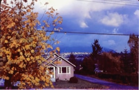
- Photograph of the "Roberts House" in its new location at 5496 Dominion Street.
- Repository
- City of Burnaby Archives
- Date
- 2015
- Collection/Fonds
- Small family fonds
- Physical Description
- 1 photograph : col. copy print ; 10 cm x 15 cm
- Description Level
- Item
- Record No.
- 620-075
- Access Restriction
- No restrictions
- Reproduction Restriction
- No reproduction permitted
- Accession Number
- 2017-01
- Scope and Content
- Photograph of the "Roberts House" in its new location at 5496 Dominion Street.
- Subjects
- Buildings - Residential - Houses
- Media Type
- Photograph
- Notes
- Transcribed title
- Title transcribed from donor's notes
- Note in blue ink on verso of photograph reads: "P.17"
- Street Address
- 5496 Dominion Street
- Historic Neighbourhood
- Burnaby Lake (Historic Neighbourhood)
- Planning Study Area
- Ardingley-Sprott Area
Images


5486 Dominion Street
https://search.heritageburnaby.ca/link/archivedescription91871
- Repository
- City of Burnaby Archives
- Date
- 1971
- Collection/Fonds
- Small family fonds
- Description Level
- Item
- Physical Description
- 1 photograph : b&w ; 9 cm x 9 cm
- Scope and Content
- Photograph of the Small family's house at 5486 Dominion Street with a "For Sale" sign on the lawn. The house was put up for sale by Lauretta Small after she inherited the Roberts' house at 5538 Dominion Street in 1969. Lauretta, by then a widow, relocated back into the Roberts' house which was th…
- Repository
- City of Burnaby Archives
- Date
- 1971
- Collection/Fonds
- Small family fonds
- Physical Description
- 1 photograph : b&w ; 9 cm x 9 cm
- Description Level
- Item
- Record No.
- 620-052
- Access Restriction
- No restrictions
- Reproduction Restriction
- No reproduction permitted
- Accession Number
- 2017-01
- Scope and Content
- Photograph of the Small family's house at 5486 Dominion Street with a "For Sale" sign on the lawn. The house was put up for sale by Lauretta Small after she inherited the Roberts' house at 5538 Dominion Street in 1969. Lauretta, by then a widow, relocated back into the Roberts' house which was the house she grew up in as a child.
- Media Type
- Photograph
- Notes
- Transcribed title
- Title transcribed from donor's notes
- Note in blue ink on verso of photograph reads: "P.14"
- Note in blue ink on verso of photograph reads: "5486 Dominion St / Burnaby, B.C. / Fall '71"
- 5486 Dominion Street later subdivided into two lots: 5480 and 5488 Dominion Street
- Street Address
- 5486 Dominion Street
- Historic Neighbourhood
- Burnaby Lake (Historic Neighbourhood)
- Planning Study Area
- Ardingley-Sprott Area
Images


5495 Dominion Street and 5505 Dominion Street
https://search.heritageburnaby.ca/link/archivedescription91857
- Repository
- City of Burnaby Archives
- Date
- April 1, 2015
- Collection/Fonds
- Small family fonds
- Description Level
- Item
- Physical Description
- 1 photograph : col. ; 10 cm x 15 cm
- Scope and Content
- Photograph of a tan duplex located at 5495 Dominion Street (left) and clay-coloured house at 5505 Dominion Street (right). The photograph was taken from 5496 Dominion street, looking north.
- Repository
- City of Burnaby Archives
- Date
- April 1, 2015
- Collection/Fonds
- Small family fonds
- Physical Description
- 1 photograph : col. ; 10 cm x 15 cm
- Description Level
- Item
- Record No.
- 620-038
- Access Restriction
- No restrictions
- Reproduction Restriction
- No reproduction permitted
- Accession Number
- 2017-01
- Scope and Content
- Photograph of a tan duplex located at 5495 Dominion Street (left) and clay-coloured house at 5505 Dominion Street (right). The photograph was taken from 5496 Dominion street, looking north.
- Subjects
- Buildings - Residential - Houses
- Media Type
- Photograph
- Notes
- Transcribed title
- Title transcribed from donor's notes
- Note in blue ink on verso of photograph reads: "P.37"
- Note in blue ink on verso of photograph reads: "April 1 , 2015 / 5495 Dominion st. 5505 Dominion St."
- 5493 Dominion Street was previously numbered 3107 Dominion Street and it was later subdivided into two lots: 5491 and 5495 Dominion Street.
- Photograph 620-037 depicts the same houses prior to being repainted.
- Historic Neighbourhood
- Burnaby Lake (Historic Neighbourhood)
- Planning Study Area
- Ardingley-Sprott Area
Images

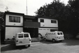
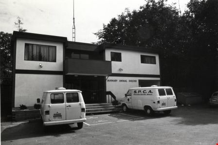
Burnaby Animal Shelter
https://search.heritageburnaby.ca/link/archivedescription79576
- Repository
- City of Burnaby Archives
- Date
- October, 1976
- Collection/Fonds
- Burnaby Public Library Contemporary Visual Archive Project
- Description Level
- Item
- Physical Description
- 1 photograph : b&w ; 11 x 16 cm mounted on cardboard
- Scope and Content
- Photograph shows the Burnaby Animal Shelter at 3202 Norland Avenue near Douglas Road. The building was opened on December 22, 1969 and is operated by the SPCA.
- Repository
- City of Burnaby Archives
- Date
- October, 1976
- Collection/Fonds
- Burnaby Public Library Contemporary Visual Archive Project
- Physical Description
- 1 photograph : b&w ; 11 x 16 cm mounted on cardboard
- Description Level
- Item
- Record No.
- 556-340
- Access Restriction
- No restrictions
- Reproduction Restriction
- Reproduce for fair dealing purposes only
- Accession Number
- 2013-13
- Scope and Content
- Photograph shows the Burnaby Animal Shelter at 3202 Norland Avenue near Douglas Road. The building was opened on December 22, 1969 and is operated by the SPCA.
- Media Type
- Photograph
- Photographer
- Cook, Alan
- Notes
- Scope note taken directly from BPL photograph description.
- 1 b&w copy negative : 10 x 12.5 cm accompanying
- Geographic Access
- Norland Avenue
- Street Address
- 3202 Norland Avenue
- Historic Neighbourhood
- Burnaby Lake (Historic Neighbourhood)
- Planning Study Area
- Ardingley-Sprott Area
Images
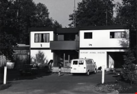
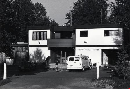
Burnaby Animal Shelter
https://search.heritageburnaby.ca/link/archivedescription79577
- Repository
- City of Burnaby Archives
- Date
- November 15, 1976
- Collection/Fonds
- Burnaby Public Library Contemporary Visual Archive Project
- Description Level
- Item
- Physical Description
- 1 photograph : b&w ; 11 x 16 cm mounted on cardboard
- Scope and Content
- Photograph shows a young child going into the Burnaby Animal Shelter at 3202 Norland Avenue near Douglas Road.
- Repository
- City of Burnaby Archives
- Date
- November 15, 1976
- Collection/Fonds
- Burnaby Public Library Contemporary Visual Archive Project
- Physical Description
- 1 photograph : b&w ; 11 x 16 cm mounted on cardboard
- Description Level
- Item
- Record No.
- 556-341
- Access Restriction
- No restrictions
- Reproduction Restriction
- Reproduce for fair dealing purposes only
- Accession Number
- 2013-13
- Scope and Content
- Photograph shows a young child going into the Burnaby Animal Shelter at 3202 Norland Avenue near Douglas Road.
- Media Type
- Photograph
- Photographer
- Salmon, Stu
- Notes
- Scope note taken directly from BPL photograph description.
- Note in pencil on verso reads: "East / Burnaby Pound. Norburn Ave / Between Douglas Road and Sprott"
- 1 b&w copy negative : 10 x 12.5 cm accompanying
- Geographic Access
- Norland Avenue
- Street Address
- 3202 Norland Avenue
- Historic Neighbourhood
- Burnaby Lake (Historic Neighbourhood)
- Planning Study Area
- Ardingley-Sprott Area
Images

Highway No. 1
https://search.heritageburnaby.ca/link/archivedescription79977
- Repository
- City of Burnaby Archives
- Date
- September 23, 1976
- Collection/Fonds
- Burnaby Public Library Contemporary Visual Archive Project
- Description Level
- Item
- Physical Description
- 1 photograph : b&w ; 11 x 16 cm mounted on cardboard
- Scope and Content
- Photograph shows a view of underdeveloped area and the No. 1 Highway looking northwest from the Sperling Overpass with Capitol Hill in the background.
- Repository
- City of Burnaby Archives
- Date
- September 23, 1976
- Collection/Fonds
- Burnaby Public Library Contemporary Visual Archive Project
- Physical Description
- 1 photograph : b&w ; 11 x 16 cm mounted on cardboard
- Description Level
- Item
- Record No.
- 556-533
- Access Restriction
- No restrictions
- Reproduction Restriction
- Reproduce for fair dealing purposes only
- Accession Number
- 2013-13
- Scope and Content
- Photograph shows a view of underdeveloped area and the No. 1 Highway looking northwest from the Sperling Overpass with Capitol Hill in the background.
- Subjects
- Aerial Photographs
- Media Type
- Photograph
- Photographer
- Campbell, Peg
- Notes
- Scope note taken directly from BPL photograph description.
- 1 b&w copy negative : 10 x 12.5 cm accompanying
- Geographic Access
- Trans Canada Highway
- Planning Study Area
- Ardingley-Sprott Area
Images

House on Norland Avenue
https://search.heritageburnaby.ca/link/archivedescription79438
- Repository
- City of Burnaby Archives
- Date
- October, 1976
- Collection/Fonds
- Burnaby Public Library Contemporary Visual Archive Project
- Description Level
- Item
- Physical Description
- 1 photograph : b&w ; 11 x 16 cm mounted on cardboard
- Scope and Content
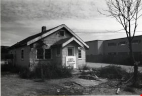
- Photograph shows a vacant house at 2874 Norland Avenue with a sign advertising the property as an industrial site.
- Repository
- City of Burnaby Archives
- Date
- October, 1976
- Collection/Fonds
- Burnaby Public Library Contemporary Visual Archive Project
- Physical Description
- 1 photograph : b&w ; 11 x 16 cm mounted on cardboard
- Description Level
- Item
- Record No.
- 556-290
- Access Restriction
- No restrictions
- Reproduction Restriction
- Reproduce for fair dealing purposes only
- Accession Number
- 2013-13
- Scope and Content
- Photograph shows a vacant house at 2874 Norland Avenue with a sign advertising the property as an industrial site.
- Media Type
- Photograph
- Photographer
- Cook, Alan
- Notes
- Scope note taken directly from BPL photograph description.
- 1 b&w copy negative : 10 x 12.5 cm accompanying
- Geographic Access
- Norland Avenue
- Street Address
- 2874 Norland Avenue
- Historic Neighbourhood
- Burnaby Lake (Historic Neighbourhood)
- Planning Study Area
- Ardingley-Sprott Area
Images

Hydro Buses
https://search.heritageburnaby.ca/link/archivedescription79477
- Repository
- City of Burnaby Archives
- Date
- October, 1976
- Collection/Fonds
- Burnaby Public Library Contemporary Visual Archive Project
- Description Level
- Item
- Physical Description
- 1 photograph : b&w ; 11 x 16 cm mounted on cardboard
- Scope and Content
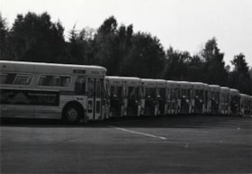
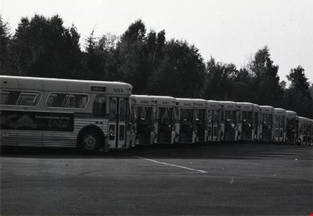
- Photograph shows Hydro buses parked outside the bus garage at 6556 Sprott Street.
- Repository
- City of Burnaby Archives
- Date
- October, 1976
- Collection/Fonds
- Burnaby Public Library Contemporary Visual Archive Project
- Physical Description
- 1 photograph : b&w ; 11 x 16 cm mounted on cardboard
- Description Level
- Item
- Record No.
- 556-309
- Access Restriction
- No restrictions
- Reproduction Restriction
- Reproduce for fair dealing purposes only
- Accession Number
- 2013-13
- Scope and Content
- Photograph shows Hydro buses parked outside the bus garage at 6556 Sprott Street.
- Subjects
- Transportation - Buses
- Media Type
- Photograph
- Photographer
- Salmon, Stu
- Notes
- Scope note taken directly from BPL photograph description.
- 1 b&w copy negative : 10 x 12.5 cm accompanying
- Geographic Access
- Sprott Street
- Street Address
- 6556 Sprott Street
- Historic Neighbourhood
- Burnaby Lake (Historic Neighbourhood)
- Planning Study Area
- Ardingley-Sprott Area
Images

Knapps Garden Shop
https://search.heritageburnaby.ca/link/archivedescription93630
- Repository
- City of Burnaby Archives
- Date
- October 22, 1977
- Collection/Fonds
- Burnaby Public Library Contemporary Visual Archive Project
- Description Level
- Item
- Physical Description
- 1 photograph : b&w ; 12.5 x 17.5 cm
- Repository
- City of Burnaby Archives
- Date
- October 22, 1977
- Collection/Fonds
- Burnaby Public Library Contemporary Visual Archive Project
- Physical Description
- 1 photograph : b&w ; 12.5 x 17.5 cm
- Description Level
- Item
- Record No.
- 556-587
- Access Restriction
- No restrictions
- Reproduction Restriction
- Reproduce for fair dealing purposes only
- Accession Number
- 2017-57
- Media Type
- Photograph
- Photographer
- Surridge, Jack
- Notes
- Title taken from project information form
- Accompanied by a project information form and 1 photograph (b&w negative ; 9.5 x 12.5 cm)
- BPL no. 36
- Geographic Access
- Lougheed Highway
- Holdom Avenue
- Planning Study Area
- Ardingley-Sprott Area
Images


Looking east along Dominion street to corner of Douglas Road and Dominion Street
https://search.heritageburnaby.ca/link/archivedescription91876
- Repository
- City of Burnaby Archives
- Date
- 2016
- Collection/Fonds
- Small family fonds
- Description Level
- Item
- Physical Description
- 1 photograph : col. ; 10 cm x 15 cm
- Scope and Content
- Photograph of Dominion Street, looking east. The houses are largely obscured by tall hedges and bushes. The photograph was taken from the north side of the street, opposite 5496 Dominion Street.
- Repository
- City of Burnaby Archives
- Date
- 2016
- Collection/Fonds
- Small family fonds
- Physical Description
- 1 photograph : col. ; 10 cm x 15 cm
- Description Level
- Item
- Record No.
- 620-057
- Access Restriction
- No restrictions
- Reproduction Restriction
- No reproduction permitted
- Accession Number
- 2017-01
- Scope and Content
- Photograph of Dominion Street, looking east. The houses are largely obscured by tall hedges and bushes. The photograph was taken from the north side of the street, opposite 5496 Dominion Street.
- Media Type
- Photograph
- Notes
- Transcribed title
- Title transcribed from donor's notes
- Note in blue ink on verso of photograph reads: "P.19"
- Note in blue ink on verso of photograph reads: "2016 / Looking East along Dominion St to corner of Douglas Rd. and Dominion St."
- Photograph 620-056 taken from the same vantage point
- Geographic Access
- Dominion Street
- Street Address
- 5538 Dominion Street
- Historic Neighbourhood
- Burnaby Lake (Historic Neighbourhood)
- Planning Study Area
- Ardingley-Sprott Area
Images


Looking east from 3131 Douglas Road
https://search.heritageburnaby.ca/link/archivedescription91826
- Repository
- City of Burnaby Archives
- Date
- January 2016
- Collection/Fonds
- Small family fonds
- Description Level
- Item
- Physical Description
- 1 photograph : col. copy print ; 15 cm x 10 cm
- Scope and Content
- Photograph of the Roberts' front yard . A large oak tree stands in the centre of the photograph with a row of short shrubs on each side. The house located at 3090 Douglas Road is visible in the distance. The photograph is taken from 3131 Douglas Road, looking east.
- Repository
- City of Burnaby Archives
- Date
- January 2016
- Collection/Fonds
- Small family fonds
- Physical Description
- 1 photograph : col. copy print ; 15 cm x 10 cm
- Description Level
- Item
- Record No.
- 620-007
- Access Restriction
- No restrictions
- Reproduction Restriction
- No reproduction permitted
- Accession Number
- 2017-01
- Scope and Content
- Photograph of the Roberts' front yard . A large oak tree stands in the centre of the photograph with a row of short shrubs on each side. The house located at 3090 Douglas Road is visible in the distance. The photograph is taken from 3131 Douglas Road, looking east.
- Media Type
- Photograph
- Notes
- Transcribed title
- Title transcribed from donor's notes
- 5118 Douglas Road renumbered to 3131 Douglas Road in 1958 and to 5538 Dominion Street in 1970 or 1971
- Note in blue ink on verso of photograph reads: "Jan. 2016 / Looking East from Roberts' front yard"
- Note in blue ink on verso of photograph reads: "P8"
- Photograph 620-003 depicts the same house on 3090 Douglas Road.
- Street Address
- 3131 Douglas Road
- 5118 Douglas Road
- 5538 Dominion Street
- 3090 Douglas Road
- Historic Neighbourhood
- Burnaby Lake (Historic Neighbourhood)
- Planning Study Area
- Ardingley-Sprott Area
Images


Looking east from north side of 5118 Douglas Road - The Roberts House
https://search.heritageburnaby.ca/link/archivedescription91821
- Repository
- City of Burnaby Archives
- Date
- 2016
- Collection/Fonds
- Small family fonds
- Description Level
- Item
- Physical Description
- 1 photograph : col. ; 10 cm x 15 cm
- Scope and Content
- Photograph of a two-storey house located at 3090 Douglas Road. The house was constructed in 1922 and is painted white with brown trim. The photograph was taken from the Roberts' property at 5538 Dominion Street.
- Repository
- City of Burnaby Archives
- Date
- 2016
- Collection/Fonds
- Small family fonds
- Physical Description
- 1 photograph : col. ; 10 cm x 15 cm
- Description Level
- Item
- Record No.
- 620-002
- Access Restriction
- No restrictions
- Reproduction Restriction
- No reproduction permitted
- Accession Number
- 2017-01
- Scope and Content
- Photograph of a two-storey house located at 3090 Douglas Road. The house was constructed in 1922 and is painted white with brown trim. The photograph was taken from the Roberts' property at 5538 Dominion Street.
- Subjects
- Buildings - Residential - Houses
- Media Type
- Photograph
- Notes
- Transcribed title
- Title transcribed from donor's notes
- The same house is visible in the background of photograph 620-001
- Note in blue ink on verso of photograph reads: "Jan. 2016 / 3090 Douglas Rd. (N.E. Corner Douglas Road and Dominion St.)
- Note in blue ink on verson of photograph reads: "P3"
- 5538 Dominion Street was previously numbered previously 5118 Douglas Road and 3131 Douglas Road
- Street Address
- 3090 Douglas Road
- Historic Neighbourhood
- Burnaby Lake (Historic Neighbourhood)
- Planning Study Area
- Ardingley-Sprott Area
Images


Looking east from north side of 5118 Douglas Road - The Roberts House
https://search.heritageburnaby.ca/link/archivedescription91825
- Repository
- City of Burnaby Archives
- Date
- 1971
- Collection/Fonds
- Small family fonds
- Description Level
- Item
- Physical Description
- 1 photograph : col. copy print ; 15 cm x 10 cm
- Scope and Content
- Photograph of the foliage, planted in the late 1920s, in the Roberts' front yard. The photograph was taken from the north side of the Roberts' property at 3131 Douglas Road, looking east.
- Repository
- City of Burnaby Archives
- Date
- 1971
- Collection/Fonds
- Small family fonds
- Physical Description
- 1 photograph : col. copy print ; 15 cm x 10 cm
- Description Level
- Item
- Record No.
- 620-006
- Access Restriction
- No restrictions
- Reproduction Restriction
- No reproduction permitted
- Accession Number
- 2017-01
- Scope and Content
- Photograph of the foliage, planted in the late 1920s, in the Roberts' front yard. The photograph was taken from the north side of the Roberts' property at 3131 Douglas Road, looking east.
- Media Type
- Photograph
- Notes
- Transcribed title
- Title transcribed from donor's notes
- 5118 Douglas Road renumbered to 3131 Douglas Road in 1958 and to 5538 Dominion Street in 1970 or 1971
- Note in blue ink on verso of photograph reads: "1971 / Looking East from Roberts' front yard""
- Note in blue ink on verso of photograph reads: "P7"
- Street Address
- 3131 Douglas Road
- 5118 Douglas Road
- 5538 Dominion Street
- Historic Neighbourhood
- Burnaby Lake (Historic Neighbourhood)
- Planning Study Area
- Ardingley-Sprott Area
Images

Looking north from 5486 Dominion Street
https://search.heritageburnaby.ca/link/archivedescription91851
- Repository
- City of Burnaby Archives
- Date
- 1971
- Collection/Fonds
- Small family fonds
- Description Level
- Item
- Physical Description
- 1 photograph : col. copy print ; 10 cm x 15 cm
- Scope and Content
- Photograph of the McLeans' house at 5493 Dominion. A large tree with autumn-coloured leaves obscures the left half of the house. The Brocklebank's backyard at 3071 Douglas Road is visible on the right. The photograph was taken from 5486 Dominion Street, looking north.
- Repository
- City of Burnaby Archives
- Date
- 1971
- Collection/Fonds
- Small family fonds
- Physical Description
- 1 photograph : col. copy print ; 10 cm x 15 cm
- Description Level
- Item
- Record No.
- 620-032
- Access Restriction
- No restrictions
- Reproduction Restriction
- No reproduction permitted
- Accession Number
- 2017-01
- Scope and Content
- Photograph of the McLeans' house at 5493 Dominion. A large tree with autumn-coloured leaves obscures the left half of the house. The Brocklebank's backyard at 3071 Douglas Road is visible on the right. The photograph was taken from 5486 Dominion Street, looking north.
- Subjects
- Buildings - Residential - Houses
- Media Type
- Photograph
- Notes
- Transcribed title
- Title transcribed from donor's notes
- Note in blue ink on verso of photograph reads: "P.32"
- Note in blue ink on verso of photograph reads: "McLean's House / 5493 Dominion St. Brocklebanks back yard / 3071 Douglas Rd. / Fall 1971"
- 5493 Dominion Street was previously numbered 3107 Dominion Street and was later subdivided into two lots: 5491 and 5495 Dominion Street.
- Photograph 620-031 was taken from the same vantage point
- Street Address
- 3071 Douglas Road
- 5493 Dominion Street
- Historic Neighbourhood
- Burnaby Lake (Historic Neighbourhood)
- Planning Study Area
- Ardingley-Sprott Area
Images


Looking northwest along Dominion Street from near Douglas Road
https://search.heritageburnaby.ca/link/archivedescription91846
- Repository
- City of Burnaby Archives
- Date
- April 2015
- Collection/Fonds
- Small family fonds
- Description Level
- Item
- Physical Description
- 1 photograph : col. copy print ; 10 cm x 15 cm
- Scope and Content
- Photograph of Dominion Street, looking northwest from near Douglas Road. The house at 3093 Douglas Road is just visible between the trees. In 2009 Dominion Street was repaved and sidewalks were installed following a local improvement request to the City.
- Repository
- City of Burnaby Archives
- Date
- April 2015
- Collection/Fonds
- Small family fonds
- Physical Description
- 1 photograph : col. copy print ; 10 cm x 15 cm
- Description Level
- Item
- Record No.
- 620-027
- Access Restriction
- No restrictions
- Reproduction Restriction
- No reproduction permitted
- Accession Number
- 2017-01
- Scope and Content
- Photograph of Dominion Street, looking northwest from near Douglas Road. The house at 3093 Douglas Road is just visible between the trees. In 2009 Dominion Street was repaved and sidewalks were installed following a local improvement request to the City.
- Subjects
- Buildings - Residential - Houses
- Media Type
- Photograph
- Notes
- Transcribed title
- Note in blue ink on verso of photograph reads: "P.27"
- Note in blue ink on verso of photograph reads: "April 2015 / Looking Northwest along Dominion St. from near Douglas Rd."
- Street Address
- 3093 Douglas Road
- Historic Neighbourhood
- Burnaby Lake (Historic Neighbourhood)
- Planning Study Area
- Ardingley-Sprott Area
Images


Looking northwest from Douglas Road
https://search.heritageburnaby.ca/link/archivedescription91835
- Repository
- City of Burnaby Archives
- Date
- October 2015
- Collection/Fonds
- Small family fonds
- Description Level
- Item
- Physical Description
- 1 photograph : col. copy print ; 10 cm x 15 cm
- Scope and Content
- Photograph of a two-storey house located at 3131 Douglas Road. The house is white with brown trim and a brown shingle roof. The large oak tree in the front yard of the property is full of vibrant autum-coloured leaves. The photograph was taken from across Douglas Road, looking northwest.
- Repository
- City of Burnaby Archives
- Date
- October 2015
- Collection/Fonds
- Small family fonds
- Physical Description
- 1 photograph : col. copy print ; 10 cm x 15 cm
- Description Level
- Item
- Record No.
- 620-016
- Access Restriction
- No restrictions
- Reproduction Restriction
- No reproduction permitted
- Accession Number
- 2017-01
- Scope and Content
- Photograph of a two-storey house located at 3131 Douglas Road. The house is white with brown trim and a brown shingle roof. The large oak tree in the front yard of the property is full of vibrant autum-coloured leaves. The photograph was taken from across Douglas Road, looking northwest.
- Media Type
- Photograph
- Notes
- Transcribed title
- Title transcribed from donor's notes
- Note in blue ink on verso of photograph reads: "Oct. 2016 / 3131 Douglas Rd. - with Oak Tree - Fall Colours"
- Note in blue ink on verso of photograph reads: "P.16"
- 5118 Douglas Road renumbered to 3131 Douglas Road in 1958 and to 5538 Dominion Street in 1970 or 1971
- The oak tree (centre) is the same tree as in photographs 620-007, 620-014, and 620-015
- Street Address
- 3131 Douglas Road
- 5118 Douglas Road
- 5538 Dominion Street
- Historic Neighbourhood
- Burnaby Lake (Historic Neighbourhood)
- Planning Study Area
- Ardingley-Sprott Area
Images

![Looking southeast from 5118 Douglas Road - The Roberts House, [between 1960 and 1975] thumbnail](/media/hpo/_Data/_Archives_Images/_Unrestricted/600/620-011.jpg?width=280)
Looking southeast from 5118 Douglas Road - The Roberts House
https://search.heritageburnaby.ca/link/archivedescription91830
- Repository
- City of Burnaby Archives
- Date
- [between 1960 and 1975]
- Collection/Fonds
- Small family fonds
- Description Level
- Item
- Physical Description
- 1 photograph : b&w ; 12.5 cm x 9 cm
- Scope and Content
- Photograph of the Manahan family's house, taken from 5118 Douglas Road, looking southeast. In the 1960s the Meyers sold a portion of their property at to the Manahan family and the house in the centre of the photograph was built. The address of the house is unknown. To the right, the Meyers' hou…
- Repository
- City of Burnaby Archives
- Date
- [between 1960 and 1975]
- Collection/Fonds
- Small family fonds
- Physical Description
- 1 photograph : b&w ; 12.5 cm x 9 cm
- Description Level
- Item
- Record No.
- 620-011
- Access Restriction
- No restrictions
- Reproduction Restriction
- No reproduction permitted
- Accession Number
- 2017-01
- Scope and Content
- Photograph of the Manahan family's house, taken from 5118 Douglas Road, looking southeast. In the 1960s the Meyers sold a portion of their property at to the Manahan family and the house in the centre of the photograph was built. The address of the house is unknown. To the right, the Meyers' house is partially visible.
- Subjects
- Buildings - Residential - Houses
- Media Type
- Photograph
- Notes
- Transcribed title
- Title transcribed from donor's notes
- 5106 Douglas Road later subdivided into 5539 and 5545 Norfolk Street
- Note in blue ink on verso of photograph reads: "(Meyers House on Right)"
- Note in blue ink on verso of photograph reads: "P11"
- Note in blue ink on verso of photograph reads: "Manahan's House"
- Note in blue ink on verso of photograph reads: "1960's or early 1970s"
- Street Address
- 5106 Douglas Road
- Historic Neighbourhood
- Burnaby Lake (Historic Neighbourhood)
- Planning Study Area
- Ardingley-Sprott Area
Images
![Looking southeast from 5118 Douglas Road - The Roberts House, [between 1960 and 1975] thumbnail](/media/hpo/_Data/_Archives_Images/_Unrestricted/600/620-011.jpg)

Looking southwest from corner of Douglas Road and Dominion Street
https://search.heritageburnaby.ca/link/archivedescription91877
- Repository
- City of Burnaby Archives
- Date
- 1978
- Collection/Fonds
- Small family fonds
- Description Level
- Item
- Physical Description
- 1 photograph : col. ; 9 cm x 13 cm
- Scope and Content
- Photograph of trees and a telephone pole situated at the southwest corner of Douglas Road and Dominion Street. The large oak, hemlock, and fir to the left of the telephone pole were planted as part of the original landscaping of the Roberts' property in the 1920s. The photograph was taken from th…
- Repository
- City of Burnaby Archives
- Date
- 1978
- Collection/Fonds
- Small family fonds
- Physical Description
- 1 photograph : col. ; 9 cm x 13 cm
- Description Level
- Item
- Record No.
- 620-058
- Access Restriction
- No restrictions
- Reproduction Restriction
- No reproduction permitted
- Accession Number
- 2017-01
- Scope and Content
- Photograph of trees and a telephone pole situated at the southwest corner of Douglas Road and Dominion Street. The large oak, hemlock, and fir to the left of the telephone pole were planted as part of the original landscaping of the Roberts' property in the 1920s. The photograph was taken from the Douglas Road and Dominion Street intersection.
- Media Type
- Photograph
- Notes
- Transcribed title
- Title transcribed from donor's notes
- Note in blue ink on verso of photograph reads: "P.20"
- Note in blue ink on verso of photograph reads: "Photo 1978"
- Note in black ink on verso of photograph reads: "Looking at S.W. corner of Douglas Rd and Dominion Street, from intersection / Oak tree, hemlock tree, and fir tree, Japanese Plum Tree"
- The oak tree is the same tree as in photographs 620-007, 620-014, 620-015, and 620-016
- Geographic Access
- Dominion Street
- Douglas Road
- Historic Neighbourhood
- Burnaby Lake (Historic Neighbourhood)
- Planning Study Area
- Ardingley-Sprott Area
Images


Looking southwest from corner of Douglas Road and Dominion Street
https://search.heritageburnaby.ca/link/archivedescription91878
- Repository
- City of Burnaby Archives
- Date
- April 2015
- Collection/Fonds
- Small family fonds
- Description Level
- Item
- Physical Description
- 1 photograph : col. copy print ; 10 cm x 15 cm
- Scope and Content
- Photograph of the houses and trees situated on the southwest corner of Douglas Road and Dominion Street. The large oak, hemlock, and fir were planted as part of the original landscaping of the Roberts' property in the 1920s. The photograph was taken from the Douglas Road and Dominion Street inter…
- Repository
- City of Burnaby Archives
- Date
- April 2015
- Collection/Fonds
- Small family fonds
- Physical Description
- 1 photograph : col. copy print ; 10 cm x 15 cm
- Description Level
- Item
- Record No.
- 620-059
- Access Restriction
- No restrictions
- Reproduction Restriction
- No reproduction permitted
- Accession Number
- 2017-01
- Scope and Content
- Photograph of the houses and trees situated on the southwest corner of Douglas Road and Dominion Street. The large oak, hemlock, and fir were planted as part of the original landscaping of the Roberts' property in the 1920s. The photograph was taken from the Douglas Road and Dominion Street intersection.
- Media Type
- Photograph
- Notes
- Transcribed title
- Title transcribed from donor's notes
- Note in blue ink on verso of photograph reads: "P.21"
- Note in blue ink on verso of photograph reads: "Looking southwest from corner of Douglas Rd. and Dominion St. / Oak Tree Hemlock Tree Fir Tree / planted in late 1920's"
- Note in black ink on verso of photograph reads: "April 2015"
- The oak tree is the same tree as in photographs 620-007, 620-014, 620-015, and 620-016
- Geographic Access
- Dominion Street
- Douglas Road
- Historic Neighbourhood
- Burnaby Lake (Historic Neighbourhood)
- Planning Study Area
- Ardingley-Sprott Area
Images


Looking west along Dominion Street from 5496 Dominion Street
https://search.heritageburnaby.ca/link/archivedescription91873
- Repository
- City of Burnaby Archives
- Date
- July 2016
- Collection/Fonds
- Small family fonds
- Description Level
- Item
- Physical Description
- 1 photograph : col. copy print ; 10 cm x 15 cm
- Scope and Content
- Photograph of the houses along Dominion Street, looking west from 5496 Dominion Street. The two houses in the foreground, 5480 and 5488 Dominion Street, were constructed in 1994 on the lot previously numbered 5486 Dominion Street.
- Repository
- City of Burnaby Archives
- Date
- July 2016
- Collection/Fonds
- Small family fonds
- Physical Description
- 1 photograph : col. copy print ; 10 cm x 15 cm
- Description Level
- Item
- Record No.
- 620-054
- Access Restriction
- No restrictions
- Reproduction Restriction
- No reproduction permitted
- Accession Number
- 2017-01
- Scope and Content
- Photograph of the houses along Dominion Street, looking west from 5496 Dominion Street. The two houses in the foreground, 5480 and 5488 Dominion Street, were constructed in 1994 on the lot previously numbered 5486 Dominion Street.
- Subjects
- Buildings - Residential - Houses
- Media Type
- Photograph
- Notes
- Transcribed title
- Title transcribed from donor's notes
- Note in blue ink on verso of photograph reads: "P.16"
- Note in blue ink on verso of photograph reads: "Houses at 5480 and 5488 Dominion St. / built in 1994"
- Photo production stamp on verso of photograph reads: "07/03/2016"
- Street Address
- 5488 Dominion Street
- 5480 Dominion Street
- Historic Neighbourhood
- Burnaby Lake (Historic Neighbourhood)
- Planning Study Area
- Ardingley-Sprott Area
Images
