5990 Irmin Street
https://search.heritageburnaby.ca/link/archivedescription98685
- Repository
- City of Burnaby Archives
- Date
- 2022
- Collection/Fonds
- Disappearing Burnaby collection
- Description Level
- Item
- Physical Description
- 1 photograph (jpeg) : col.
- Scope and Content
- Photograph of a multi-storey house located at 5990 Irmin Street. The photograph depicts of the exterior of the house at dusk; a light is on in one of the house's rooms and a vehicle is parked in the house's driveway next to a portable garage. A "For Sale" sign on the edge of the property reads: "Fu…
- Repository
- City of Burnaby Archives
- Date
- 2022
- Collection/Fonds
- Disappearing Burnaby collection
- Physical Description
- 1 photograph (jpeg) : col.
- Description Level
- Item
- Record No.
- 634-032
- Access Restriction
- No restrictions
- Reproduction Restriction
- No restrictions
- Accession Number
- 2022-14
- Scope and Content
- Photograph of a multi-storey house located at 5990 Irmin Street. The photograph depicts of the exterior of the house at dusk; a light is on in one of the house's rooms and a vehicle is parked in the house's driveway next to a portable garage. A "For Sale" sign on the edge of the property reads: "Future Development Land." Another house is visible in the background. The house was constructed in 1923 and is nearby to 7530 Buller Avenue.
- Media Type
- Photograph
- Photographer
- Cheung, Nakita
- Notes
- Title taken from the associated blog post
- Associated blog post: https://disappearingburnaby.wordpress.com/2022/06/30/william-esther-burdick-residence/
- Geographic Access
- Irmin Street
- Street Address
- 5990 Irmin Street
- Historic Neighbourhood
- Alta Vista (Historic Neighbourhood)
- Planning Study Area
- Clinton-Glenwood Area
Images


7530 Buller Avenue
https://search.heritageburnaby.ca/link/archivedescription98686
- Repository
- City of Burnaby Archives
- Date
- 2022
- Collection/Fonds
- Disappearing Burnaby collection
- Description Level
- Item
- Physical Description
- 1 photograph (jpeg) : col.
- Scope and Content
- Photograph of the exterior of a two-storey house located at 7530 Buller Avenue. The photograph depicts the house at dusk; the house stands behind a wooden fence and is surrounded by trees. The house was constructed in 1924 and was formerly known as "Ryverbrae," the William & Esther Burdick Residenc…
- Repository
- City of Burnaby Archives
- Date
- 2022
- Collection/Fonds
- Disappearing Burnaby collection
- Physical Description
- 1 photograph (jpeg) : col.
- Description Level
- Item
- Record No.
- 634-033
- Access Restriction
- No restrictions
- Reproduction Restriction
- No restrictions
- Accession Number
- 2022-14
- Scope and Content
- Photograph of the exterior of a two-storey house located at 7530 Buller Avenue. The photograph depicts the house at dusk; the house stands behind a wooden fence and is surrounded by trees. The house was constructed in 1924 and was formerly known as "Ryverbrae," the William & Esther Burdick Residence.
- Media Type
- Photograph
- Photographer
- Cheung, Nakita
- Notes
- Title taken from the associated blog post
- Associated blog post: https://disappearingburnaby.wordpress.com/2022/06/30/william-esther-burdick-residence/
- Geographic Access
- Buller Avenue
- Street Address
- 7530 Buller Avenue
- Historic Neighbourhood
- Alta Vista (Historic Neighbourhood)
- Planning Study Area
- Clinton-Glenwood Area
Images

Ocean View Burial Park
https://search.heritageburnaby.ca/link/archivedescription36598
- Repository
- City of Burnaby Archives
- Date
- 1930
- Collection/Fonds
- Burnaby Historical Society fonds
- Description Level
- Item
- Physical Description
- 1 photograph : sepia ; 19 x 24 cm
- Scope and Content
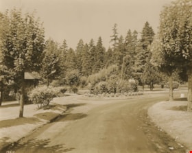
- Photograph of the roundabout at Ocean View Burial Park.
- Repository
- City of Burnaby Archives
- Date
- 1930
- Collection/Fonds
- Burnaby Historical Society fonds
- Subseries
- Photographs subseries
- Physical Description
- 1 photograph : sepia ; 19 x 24 cm
- Description Level
- Item
- Record No.
- 306-001
- Access Restriction
- No restrictions
- Reproduction Restriction
- No known restrictions
- Accession Number
- BHS1992-48
- Scope and Content
- Photograph of the roundabout at Ocean View Burial Park.
- Subjects
- Cemeteries
- Names
- Ocean View Burial Park
- Media Type
- Photograph
- Photographer
- Frank, Leonard
- Notes
- Title based on contents of photograph
- Photographer identifies item as no. 19610
- Geographic Access
- Imperial Street
- Street Address
- 4000 Imperial Street
- Historic Neighbourhood
- Alta-Vista (Historic Neighbourhood)
- Planning Study Area
- Suncrest Area
Images

Ocean View Burial Park
https://search.heritageburnaby.ca/link/archivedescription36599
- Repository
- City of Burnaby Archives
- Date
- 1930
- Collection/Fonds
- Burnaby Historical Society fonds
- Description Level
- Item
- Physical Description
- 1 photograph : sepia ; 19 x 24 cm
- Scope and Content
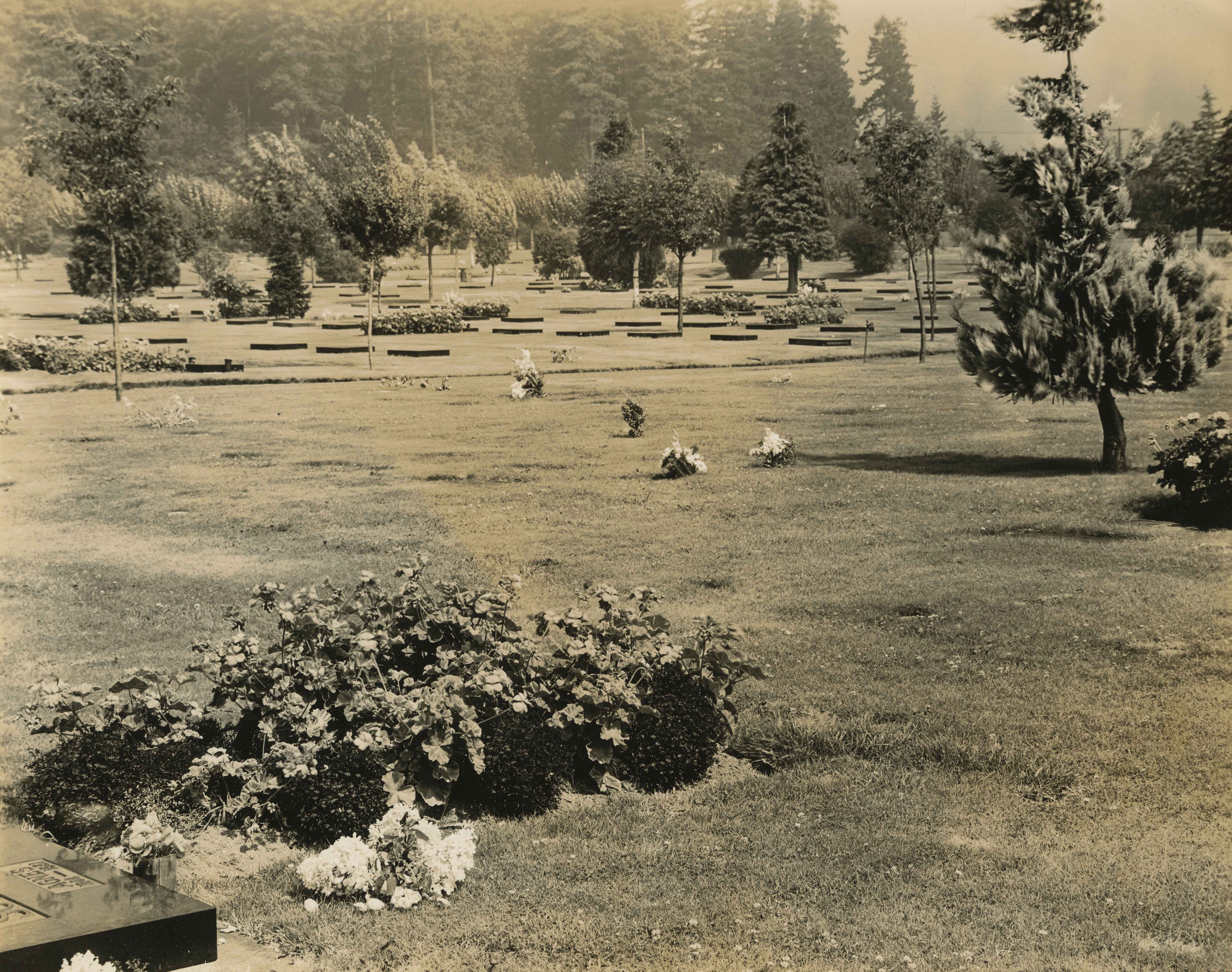
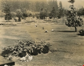
- Photograph of a grave site and the surrounding cemetery land at Ocean View Burial Park.
- Repository
- City of Burnaby Archives
- Date
- 1930
- Collection/Fonds
- Burnaby Historical Society fonds
- Subseries
- Photographs subseries
- Physical Description
- 1 photograph : sepia ; 19 x 24 cm
- Description Level
- Item
- Record No.
- 306-002
- Access Restriction
- No restrictions
- Reproduction Restriction
- No known restrictions
- Accession Number
- BHS1992-48
- Scope and Content
- Photograph of a grave site and the surrounding cemetery land at Ocean View Burial Park.
- Subjects
- Cemeteries
- Names
- Ocean View Burial Park
- Media Type
- Photograph
- Photographer
- Frank, Leonard
- Notes
- Title based on contents of photograph
- Photographer identifies item as no. 19652
- Geographic Access
- Imperial Street
- Street Address
- 4000 Imperial Street
- Historic Neighbourhood
- Alta-Vista (Historic Neighbourhood)
- Planning Study Area
- Suncrest Area
Images