Narrow Results By
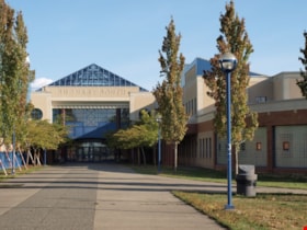
Burnaby South Secondary School and The B.C. Provincial School for the Deaf
https://search.heritageburnaby.ca/link/landmark844
- Repository
- Burnaby Heritage Planning
- Geographic Access
- Rumble Street
- Associated Dates
- 1993
- Heritage Value
- The original Burnaby South High School was replaced in 1993 and the new Burnaby South Secondary School and BC Provincial School for the Deaf was built at this location. This school was built with the latest technology and modern equipment to ensure it was fully accessible and offers integrated academic, social and recreational activities for its students.
- Historic Neighbourhood
- Alta Vista (Historic Neighbourhood)
- Planning Study Area
- Clinton-Glenwood Area
- Street Address
- 5455 Rumble Street
- Street View URL
- Google Maps Street View
Images
McPherson Park Junior High School
https://search.heritageburnaby.ca/link/landmark710
- Repository
- Burnaby Heritage Planning
- Associated Dates
- 1951-1993
- Street View URL
- Google Maps Street View
- Repository
- Burnaby Heritage Planning
- Geographic Access
- Rumble Street
- Associated Dates
- 1951-1993
- Heritage Value
- In 1950, the Burnaby School Inspector reported: "the recent development of a number of large housing projects and the continuing growth of new homes in settled areas are compelling the Board to consider a building program of major proportions...now under construction, including McPherson Park with 21 classrooms." Enrolment in its first year was 686 students. In the late 1980s and early 1990s, junior high schools were replaced with expanded secondary schools encompassing grades 7 through 12; as a result, McPherson Park Junior High was closed and Burnaby South Secondary School opened.
- Historic Neighbourhood
- Alta Vista (Historic Neighbourhood)
- Planning Study Area
- Clinton-Glenwood Area
- Street Address
- 5455 Rumble Street
- Street View URL
- Google Maps Street View
Roy & Catherine Cummins House
https://search.heritageburnaby.ca/link/landmark506
- Repository
- Burnaby Heritage Planning
- Description
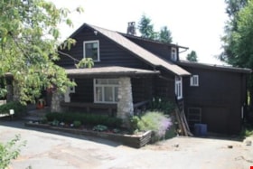
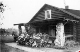
- Located on Rumble Street in the Alta Vista neighbourhood, the Roy and Catherine Cummins House is a one and one-half storey, front-gabled rustic Arts and Crafts house, distinguished by the use of log construction and fieldstone verandah columns.
- Associated Dates
- 1912
- Formal Recognition
- Heritage Designation, Community Heritage Register
- Street View URL
- Google Maps Street View
- Repository
- Burnaby Heritage Planning
- Geographic Access
- Rumble Street
- Associated Dates
- 1912
- Formal Recognition
- Heritage Designation, Community Heritage Register
- Enactment Type
- By-law No. 11959
- Enactment Date
- 17/10/2005
- Description
- Located on Rumble Street in the Alta Vista neighbourhood, the Roy and Catherine Cummins House is a one and one-half storey, front-gabled rustic Arts and Crafts house, distinguished by the use of log construction and fieldstone verandah columns.
- Heritage Value
- The Roy and Catherine Cummins House is valued for its association with the early settlement of Burnaby. Its construction is linked to the opening of the Burnaby Lake Interurban line, which ran through the central part of Burnaby, providing access between Vancouver and New Westminster. The accessibility of the area, combined with spectacular views of the Fraser River, made Alta Vista a desirable Edwardian era middle-class neighbourhood. The house was built in 1912 for Roy Franklin Cummins and his wife, Catherine Emma Cummins (née Cook), shortly after their marriage. Roy Cummins was a lineman with the B.C. Electric Railway Company, an economic driving force in Burnaby. The Roy and Catherine Cummins House is a unique and sophisticated local example of a rustic Arts and Crafts structure. Roy Cummins constructed the house from logs cleared for the construction of Rumble Street; the house is also unique for its use of local fieldstone for its verandah columns and chimney. Reminiscent of park lodge architecture, it exemplifies the semi-wild nature of the area as it was being opened for subdivision. It is also an indication of how far Burnaby was removed from the more urban lifestyles and attitudes of Vancouver and New Westminster.
- Defining Elements
- Key elements that define the heritage character of the Roy and Catherine Cummins House include its: - location on a steeply sloping site in the Alta Vista neighbourhood of Burnaby - residential form, scale and massing as expressed by its one and one-half storey height plus full basement, front-gabled roof and shed dormer, full open front verandah and partial rear verandah - peeled log construction including notched corner posts, log verandah roof framing and log balustrades - masonry elements including fieldstone verandah columns and internal chimney, and board-formed concrete foundations with fieldstone aggregate - rustic Arts and Crafts features such as the use of natural materials, tapered columns, front door with sidelights and exposed eave purlins - original windows, including wooden sash casement windows in multiple assembly with continuous transoms - interior features including fir-panelled walls, wooden mouldings and fieldstone fireplace - associated landscape features including terraced stone walls
- Historic Neighbourhood
- Alta Vista (Historic Neighbourhood)
- Planning Study Area
- Sussex-Nelson Area
- Function
- Primary Historic--Single Dwelling
- Primary Current--Single Dwelling
- Community
- Alta Vista
- Cadastral Identifier
- P.I.D.026-635-534
- Boundaries
- The Roy and Catherine Cummins House is comprised of a single residential lot located at 4156 Rumble Street, Burnaby.
- Area
- 718
- Contributing Resource
- Building
- Ownership
- Private
- Documentation
- City of Burnaby Planning and Building Department, Heritage Site Files
- Street Address
- 4156 Rumble Street
- Street View URL
- Google Maps Street View
Images
Suncrest School
https://search.heritageburnaby.ca/link/landmark694
- Repository
- Burnaby Heritage Planning
- Geographic Access
- Rumble Street
- Associated Dates
- 1953
- Heritage Value
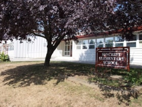
- The new Suncrest subdivision developed in the early 1950s, resulting in 312 new homes in 1951, with an additional 100 being planned. As a result, enrolment pressure resulted in the construction of Suncrest School in 1953. Additions to the original structure were made in 1954 and a library, change rooms and staffroom were added in 1969.
- Historic Neighbourhood
- Alta Vista (Historic Neighbourhood)
- Planning Study Area
- Suncrest Area
- Street Address
- 3883 Rumble Street
- Street View URL
- Google Maps Street View


