Narrow Results By
Subject
- Advertising Medium - Signs and Signboards 3
- Aerial Photographs 2
- Agriculture - Farms 2
- Agriculture - Orchards 1
- Animals - Cows 1
- Animals - Dogs 10
- Arts - Paintings 1
- Buildings - Civic - Hospitals 2
- Buildings - Civic - Seniors Centres 1
- Buildings - Commercial 4
- Buildings - Commercial - Barber Shops 5
- Buildings - Commercial - Beauty Shops 2
Creator
- Bartel, Mario 33
- Bellinger, Bernard 2
- British Columbia Underwriters' Association 3
- Burnett and McGugan B.C. Land Surveyors, New Westminster 1
- Burnett & McGugan, Engineers and Surveyors 1
- Cheung, Nakita 2
- Cook, Alan 5
- Disney, John Harold "Jack" 4
- Flanagan, Colleen 1
- Frank, Leonard 2
- Geoffrey K. Burnett 1
- Jensen, Steve 2
![Dundonald United Church, [between 1911 and 1919] thumbnail](/media/hpo/_Data/_Archives_Images/_Unrestricted/316/325-022.jpg?width=280)
Dundonald United Church
https://search.heritageburnaby.ca/link/archivedescription37150
- Repository
- City of Burnaby Archives
- Date
- [between 1911 and 1919]
- Collection/Fonds
- Burnaby Historical Society fonds
- Description Level
- Item
- Physical Description
- 1 photograph : b&w ; 8.5 x 12.5 cm print
- Scope and Content
- Photograph of Dundonald United Church, taken from the school grounds of Riverway East (later renamed Dundonald School).
- Repository
- City of Burnaby Archives
- Date
- [between 1911 and 1919]
- Collection/Fonds
- Burnaby Historical Society fonds
- Subseries
- Disney family subseries
- Physical Description
- 1 photograph : b&w ; 8.5 x 12.5 cm print
- Description Level
- Item
- Record No.
- 325-022
- Access Restriction
- No restrictions
- Reproduction Restriction
- No known restrictions
- Accession Number
- BHS1996-04
- Scope and Content
- Photograph of Dundonald United Church, taken from the school grounds of Riverway East (later renamed Dundonald School).
- Subjects
- Buildings - Religious - Churches
- Media Type
- Photograph
- Photographer
- Disney, John Harold "Jack"
- Notes
- Title based on contents of photograph
- Geographic Access
- Marine Drive
- Clinton Street
- Gilley Avenue
- Curragh Avenue
- Historic Neighbourhood
- Alta-Vista (Historic Neighbourhood)
- Planning Study Area
- Clinton-Glenwood Area
Images
![Dundonald United Church, [between 1911 and 1919] thumbnail](/media/hpo/_Data/_Archives_Images/_Unrestricted/316/325-022.jpg)
![Earthquake preparedness at Nelson Avenue School, [2001] thumbnail](/media/hpo/_Data/_Archives_Images/_Unrestricted/535/535-1650-2.jpg?width=280)
Earthquake preparedness at Nelson Avenue School
https://search.heritageburnaby.ca/link/archivedescription95849
- Repository
- City of Burnaby Archives
- Date
- [2001]
- Collection/Fonds
- Burnaby NewsLeader photograph collection
- Description Level
- File
- Physical Description
- 2 photographs (tiff) : col.
- Scope and Content
- File contains photographs of students at Nelson Avenue School presenting and learning about their earthquake preparedness supplies.
- Repository
- City of Burnaby Archives
- Date
- [2001]
- Collection/Fonds
- Burnaby NewsLeader photograph collection
- Physical Description
- 2 photographs (tiff) : col.
- Description Level
- File
- Record No.
- 535-1650
- Access Restriction
- No restrictions
- Reproduction Restriction
- No restrictions
- Accession Number
- 2018-12
- Scope and Content
- File contains photographs of students at Nelson Avenue School presenting and learning about their earthquake preparedness supplies.
- Subjects
- Persons - Students
- Buildings - Schools
- Names
- Nelson Avenue School
- Media Type
- Photograph
- Photographer
- Ponne, Simone
- Notes
- Title based on original file name
- Collected by editorial for use in a March 2001 issue of the Burnaby NewsLeader
- Caption from metadata: "Nelson elementary"
- Geographic Access
- Irmin Street
- Street Address
- 4850 Irmin Street
- Historic Neighbourhood
- Alta Vista (Historic Neighbourhood)
- Planning Study Area
- Sussex-Nelson Area
Images
![Earthquake preparedness at Nelson Avenue School, [2001] thumbnail](/media/hpo/_Data/_Archives_Images/_Unrestricted/535/535-1650-2.jpg)
![Ella Hardy, [between 1925 and 1929] (date of original), copied 1991 thumbnail](/media/hpo/_Data/_Archives_Images/_Unrestricted/370/370-666.jpg?width=280)
Ella Hardy
https://search.heritageburnaby.ca/link/archivedescription38079
- Repository
- City of Burnaby Archives
- Date
- [between 1925 and 1929] (date of original), copied 1991
- Collection/Fonds
- Burnaby Historical Society fonds
- Description Level
- Item
- Physical Description
- 1 photograph : b&w ; 4.5 x 2.5 cm print on contact sheet 20.2 x 26.2 cm
- Scope and Content
- Photograph of Ella Hardy standing in the front yard of 2830 McKee Street (later renumbered as 5850 McKee Street).
- Repository
- City of Burnaby Archives
- Date
- [between 1925 and 1929] (date of original), copied 1991
- Collection/Fonds
- Burnaby Historical Society fonds
- Subseries
- Burnaby Image Bank subseries
- Physical Description
- 1 photograph : b&w ; 4.5 x 2.5 cm print on contact sheet 20.2 x 26.2 cm
- Description Level
- Item
- Record No.
- 370-666
- Access Restriction
- No restrictions
- Reproduction Restriction
- No restrictions
- Accession Number
- BHS1999-03
- Scope and Content
- Photograph of Ella Hardy standing in the front yard of 2830 McKee Street (later renumbered as 5850 McKee Street).
- Names
- Spencer, Ella Hardy
- Media Type
- Photograph
- Notes
- Title based on contents of photograph
- 1 b&w copy negative accompanying
- Negative has a pink cast
- Geographic Access
- McKee Street
- Street Address
- 5850 McKee Street
- Historic Neighbourhood
- Alta-Vista (Historic Neighbourhood)
- Planning Study Area
- Clinton-Glenwood Area
Images
![Ella Hardy, [between 1925 and 1929] (date of original), copied 1991 thumbnail](/media/hpo/_Data/_Archives_Images/_Unrestricted/370/370-666.jpg)
![England family home on Royal Oak Avenue, [between 1927 and 1930] (date of original) , copied 2020 thumbnail](/media/hpo/_Data/_BVM_Images/2020/2020_0009_0002_001.jpg?width=280)
England family home on Royal Oak Avenue
https://search.heritageburnaby.ca/link/museumdescription12230
- Repository
- Burnaby Village Museum
- Date
- [between 1927 and 1930] (date of original) , copied 2020
- Collection/Fonds
- Mary England fonds
- Description Level
- Item
- Physical Description
- 1 photograph (tiff) : b&w ; 600 dpi
- Scope and Content
- Photograph of a Craftsman style house located at 1906 Royal Oak Avenue near Victory Street in Burnaby (address was changed to 7353 Royal Oak Aveue after 1958). The house was built in 1914 and was the home of Alfred Henry and Mary England (nee Gooding). Alfred H. England died suddenly in 1917. Mary…
- Repository
- Burnaby Village Museum
- Collection/Fonds
- Mary England fonds
- Description Level
- Item
- Physical Description
- 1 photograph (tiff) : b&w ; 600 dpi
- Scope and Content
- Photograph of a Craftsman style house located at 1906 Royal Oak Avenue near Victory Street in Burnaby (address was changed to 7353 Royal Oak Aveue after 1958). The house was built in 1914 and was the home of Alfred Henry and Mary England (nee Gooding). Alfred H. England died suddenly in 1917. Mary England continued to live in the house before settling in a house that she had built on Griffiths Avenue in 1930.
- Subjects
- Buildings - Residential - Houses
- Geographic Access
- Royal Oak Avenue
- Victory Street
- Accession Code
- BV020.9.2
- Access Restriction
- No restrictions
- Reproduction Restriction
- May be restricted by third party rights
- Date
- [between 1927 and 1930] (date of original) , copied 2020
- Media Type
- Photograph
- Historic Neighbourhood
- Central Park (Historic Neighbourhood)
- Alta Vista (Historic Neighbourhood)
- Planning Study Area
- Clinton-Glenwood Area
- Scan Resolution
- 600
- Scan Date
- 12-Feb-20
- Scale
- 100
- Notes
- Title based on contents of photograph
Images
![England family home on Royal Oak Avenue, [between 1927 and 1930] (date of original) , copied 2020 thumbnail](/media/hpo/_Data/_BVM_Images/2020/2020_0009_0002_001.jpg)
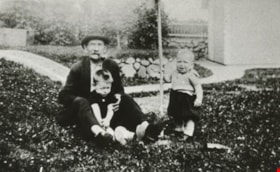
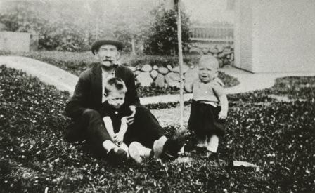
Erickson and Bezanson family
https://search.heritageburnaby.ca/link/archivedescription35854
- Repository
- City of Burnaby Archives
- Date
- 1928 (date of original), copied 1986
- Collection/Fonds
- Burnaby Historical Society fonds
- Description Level
- Item
- Physical Description
- 1 photograph : b&w ; 12.7 x 17.8 cm print
- Scope and Content
- Photograph of Grandfather Erickson, and brothers Albert Bezanson (sitting) and Charlie Bezanson (standing). They were part of the Icelandic community in South Burnaby, most of them carpenters.
- Repository
- City of Burnaby Archives
- Date
- 1928 (date of original), copied 1986
- Collection/Fonds
- Burnaby Historical Society fonds
- Subseries
- Pioneer Tales subseries
- Physical Description
- 1 photograph : b&w ; 12.7 x 17.8 cm print
- Description Level
- Item
- Record No.
- 204-713
- Access Restriction
- No restrictions
- Reproduction Restriction
- No known restrictions
- Accession Number
- BHS1988-03
- Scope and Content
- Photograph of Grandfather Erickson, and brothers Albert Bezanson (sitting) and Charlie Bezanson (standing). They were part of the Icelandic community in South Burnaby, most of them carpenters.
- Media Type
- Photograph
- Notes
- Title based on contents of photograph
- Geographic Access
- Royal Oak Avenue
- Street Address
- 7883 Royal Oak Avenue
- Historic Neighbourhood
- Alta-Vista (Historic Neighbourhood)
- Planning Study Area
- Clinton-Glenwood Area
Images
![Evelyn and Lyle Le Grove, [1937] (date of original), copied 1991 thumbnail](/media/hpo/_Data/_Archives_Images/_Unrestricted/370/370-642.jpg?width=280)
Evelyn and Lyle Le Grove
https://search.heritageburnaby.ca/link/archivedescription38055
- Repository
- City of Burnaby Archives
- Date
- [1937] (date of original), copied 1991
- Collection/Fonds
- Burnaby Historical Society fonds
- Description Level
- Item
- Physical Description
- 1 photograph : b&w ; 3.9 x 2.9 cm print on contact sheet 20.4 x 26.5 cm
- Scope and Content
- Photograph of Evelyn and Lyle Le Grove at 2930 McKee Street (later renumbered 5850 McKee Street).
- Repository
- City of Burnaby Archives
- Date
- [1937] (date of original), copied 1991
- Collection/Fonds
- Burnaby Historical Society fonds
- Subseries
- Burnaby Image Bank subseries
- Physical Description
- 1 photograph : b&w ; 3.9 x 2.9 cm print on contact sheet 20.4 x 26.5 cm
- Description Level
- Item
- Record No.
- 370-642
- Access Restriction
- No restrictions
- Reproduction Restriction
- No known restrictions
- Accession Number
- BHS1999-03
- Scope and Content
- Photograph of Evelyn and Lyle Le Grove at 2930 McKee Street (later renumbered 5850 McKee Street).
- Media Type
- Photograph
- Notes
- Title based on contents of photograph
- 1 b&w copy negative accompanying
- Negative has a pink cast
- Geographic Access
- McKee Street
- Street Address
- 5850 McKee Street
- Historic Neighbourhood
- Alta-Vista (Historic Neighbourhood)
- Planning Study Area
- Clinton-Glenwood Area
Images
![Evelyn and Lyle Le Grove, [1937] (date of original), copied 1991 thumbnail](/media/hpo/_Data/_Archives_Images/_Unrestricted/370/370-642.jpg)
![Evelyn Hardy-Le Grove, Marie Hardy and Helen Hardy, [1939] (date of original), copied 1991 thumbnail](/media/hpo/_Data/_Archives_Images/_Unrestricted/370/370-647.jpg?width=280)
Evelyn Hardy-Le Grove, Marie Hardy and Helen Hardy
https://search.heritageburnaby.ca/link/archivedescription38059
- Repository
- City of Burnaby Archives
- Date
- [1939] (date of original), copied 1991
- Collection/Fonds
- Burnaby Historical Society fonds
- Description Level
- Item
- Physical Description
- 1 photograph : b&w ; 2.9 x 4.3 cm print on contact sheet 20.4 x 26.5 cm
- Scope and Content
- Photograph of mother and daughters (left to right) Evelyn Hardy Le Grove, Marie Hardy (mother) and Helen Hardy in the yard at 2930 McKee Street (later renumbered 5850 McKee Street).
- Repository
- City of Burnaby Archives
- Date
- [1939] (date of original), copied 1991
- Collection/Fonds
- Burnaby Historical Society fonds
- Subseries
- Burnaby Image Bank subseries
- Physical Description
- 1 photograph : b&w ; 2.9 x 4.3 cm print on contact sheet 20.4 x 26.5 cm
- Description Level
- Item
- Record No.
- 370-647
- Access Restriction
- No restrictions
- Reproduction Restriction
- No known restrictions
- Accession Number
- BHS1999-03
- Scope and Content
- Photograph of mother and daughters (left to right) Evelyn Hardy Le Grove, Marie Hardy (mother) and Helen Hardy in the yard at 2930 McKee Street (later renumbered 5850 McKee Street).
- Media Type
- Photograph
- Notes
- Title based on contents of photograph
- 1 b&w copy negative accompanying
- Negative has a pink cast
- Geographic Access
- McKee Street
- Street Address
- 5850 McKee Street
- Historic Neighbourhood
- Alta-Vista (Historic Neighbourhood)
- Planning Study Area
- Clinton-Glenwood Area
Images
![Evelyn Hardy-Le Grove, Marie Hardy and Helen Hardy, [1939] (date of original), copied 1991 thumbnail](/media/hpo/_Data/_Archives_Images/_Unrestricted/370/370-647.jpg)
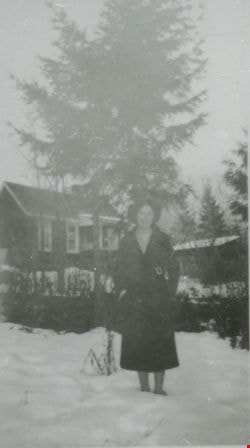
Evelyn Le Grove
https://search.heritageburnaby.ca/link/archivedescription38047
- Repository
- City of Burnaby Archives
- Date
- February 1933 (date of original), copied 1991
- Collection/Fonds
- Burnaby Historical Society fonds
- Description Level
- Item
- Physical Description
- 1 photograph : b&w ; 4.4 x 2.5 cm print on contact sheet 20.2 x 26.6 cm
- Scope and Content
- Photograph of Evelyn Le Grove at McGregor Avenue and Portland Street in the snow. A house can be seen in the background.
- Repository
- City of Burnaby Archives
- Date
- February 1933 (date of original), copied 1991
- Collection/Fonds
- Burnaby Historical Society fonds
- Subseries
- Burnaby Image Bank subseries
- Physical Description
- 1 photograph : b&w ; 4.4 x 2.5 cm print on contact sheet 20.2 x 26.6 cm
- Description Level
- Item
- Record No.
- 370-634
- Access Restriction
- No restrictions
- Reproduction Restriction
- No known restrictions
- Accession Number
- BHS1999-03
- Scope and Content
- Photograph of Evelyn Le Grove at McGregor Avenue and Portland Street in the snow. A house can be seen in the background.
- Names
- Le Grove, Evelyn Hardy
- Media Type
- Photograph
- Notes
- Title based on contents of photograph
- 1 b&w copy negative accompanying
- Negative has a pink cast
- Geographic Access
- McGregor Avenue
- Portland Street
- Historic Neighbourhood
- Alta-Vista (Historic Neighbourhood)
- Planning Study Area
- Sussex-Nelson Area
Images

Evelyn's Beauty Salon
https://search.heritageburnaby.ca/link/archivedescription79191
- Repository
- City of Burnaby Archives
- Date
- September 22, 1976
- Collection/Fonds
- Burnaby Public Library Contemporary Visual Archive Project
- Description Level
- Item
- Physical Description
- 1 photograph : b&w ; 11 x 16 cm mounted on cardboard
- Scope and Content
- Photograph shows Evelyn's Beauty Salon at 7030 Buller Avenue next door to the P&K Convenient Food Market.
- Repository
- City of Burnaby Archives
- Date
- September 22, 1976
- Collection/Fonds
- Burnaby Public Library Contemporary Visual Archive Project
- Physical Description
- 1 photograph : b&w ; 11 x 16 cm mounted on cardboard
- Description Level
- Item
- Record No.
- 556-199
- Access Restriction
- No restrictions
- Reproduction Restriction
- Reproduce for fair dealing purposes only
- Accession Number
- 2013-13
- Scope and Content
- Photograph shows Evelyn's Beauty Salon at 7030 Buller Avenue next door to the P&K Convenient Food Market.
- Media Type
- Photograph
- Photographer
- Ross, Martha
- Notes
- Scope note taken directly from BPL photograph description.
- 1 b&w copy negative : 10 x 12.5 cm accompanying
- Geographic Access
- Buller Avenue
- Street Address
- 7930 Buller Avenue
- Historic Neighbourhood
- Alta-Vista (Historic Neighbourhood)
- Planning Study Area
- Clinton-Glenwood Area
Images


Extension of McPherson Park School
https://search.heritageburnaby.ca/link/archivedescription36489
- Repository
- City of Burnaby Archives
- Date
- September 1959
- Collection/Fonds
- Burnaby Historical Society fonds
- Description Level
- Item
- Physical Description
- 1 photograph : b&w ; 8.5 x 12.5 cm print
- Scope and Content
- Photograph of the A.J. Keel house with excavation for the extension of the McPherson Park School.
- Repository
- City of Burnaby Archives
- Date
- September 1959
- Collection/Fonds
- Burnaby Historical Society fonds
- Subseries
- Keel family subseries
- Physical Description
- 1 photograph : b&w ; 8.5 x 12.5 cm print
- Description Level
- Item
- Record No.
- 279-002
- Access Restriction
- No restrictions
- Reproduction Restriction
- Reproduce for fair dealing purposes only
- Accession Number
- BHS1992-09
- Scope and Content
- Photograph of the A.J. Keel house with excavation for the extension of the McPherson Park School.
- Names
- McPherson Park School
- Media Type
- Photograph
- Notes
- Title based on contents of photograph
- Geographic Access
- Rumble Street
- Historic Neighbourhood
- Alta-Vista (Historic Neighbourhood)
- Planning Study Area
- Clinton-Glenwood Area
Images


Extension of McPherson Park School
https://search.heritageburnaby.ca/link/archivedescription36490
- Repository
- City of Burnaby Archives
- Date
- September 1959
- Collection/Fonds
- Burnaby Historical Society fonds
- Description Level
- Item
- Physical Description
- 1 photograph : b&w ; 8.5 x 12.5 cm print
- Scope and Content
- Photograph of the A.J. Keel house with a close-up of the excavation for the extension of McPherson Park School.
- Repository
- City of Burnaby Archives
- Date
- September 1959
- Collection/Fonds
- Burnaby Historical Society fonds
- Subseries
- Keel family subseries
- Physical Description
- 1 photograph : b&w ; 8.5 x 12.5 cm print
- Description Level
- Item
- Record No.
- 279-003
- Access Restriction
- No restrictions
- Reproduction Restriction
- Reproduce for fair dealing purposes only
- Accession Number
- BHS1992-09
- Scope and Content
- Photograph of the A.J. Keel house with a close-up of the excavation for the extension of McPherson Park School.
- Names
- McPherson Park School
- Media Type
- Photograph
- Notes
- Title based on contents of photograph
- Geographic Access
- Rumble Street
- Historic Neighbourhood
- Alta-Vista (Historic Neighbourhood)
- Planning Study Area
- Clinton-Glenwood Area
Images

![The Fair Haven, [between 1950 and 1957] thumbnail](/media/Hpo/_Data/_Archives_Images/_Unrestricted/251/305-001.jpg?width=280)
The Fair Haven
https://search.heritageburnaby.ca/link/archivedescription36597
- Repository
- City of Burnaby Archives
- Date
- [between 1950 and 1957]
- Collection/Fonds
- Burnaby Historical Society fonds
- Description Level
- Item
- Physical Description
- 1 photograph : col. postcard ; 9 x 14 cm
- Scope and Content
- Aerial photographic postcard of "the Fair Haven," a group of United Church homes for Senior Citizens. The road in the foreground is Rumble Street, and the long road to the right is Sussex Avenue. The small forest behind "the Fair Haven" is the David Gary Park.
- Repository
- City of Burnaby Archives
- Date
- [between 1950 and 1957]
- Collection/Fonds
- Burnaby Historical Society fonds
- Subseries
- Vera Jackson Pel subseries
- Physical Description
- 1 photograph : col. postcard ; 9 x 14 cm
- Description Level
- Item
- Record No.
- 305-001
- Access Restriction
- No restrictions
- Reproduction Restriction
- Reproduce for fair dealing purposes only
- Accession Number
- BHS1992-46
- Scope and Content
- Aerial photographic postcard of "the Fair Haven," a group of United Church homes for Senior Citizens. The road in the foreground is Rumble Street, and the long road to the right is Sussex Avenue. The small forest behind "the Fair Haven" is the David Gary Park.
- Subjects
- Aerial Photographs
- Documentary Artifacts - Postcards
- Buildings - Residential - Seniors Housing
- Names
- Fair Haven
- Media Type
- Photograph
- Notes
- Typewritten note on verso of postcard reads: "AERIAL VIEW/ 'The Fairhaven', Burnaby BC / United Church Homes for Senior Citizens / 4341 Rumble St., Burnaby, BC"
- Handwritten note on verso of postcard reads: ""The road in the foreground is Rumble Street. The long road to the right is Sussex Avenue. The road, going up, on the left, barely visible is McKay Avenue = lower corner. Behind Fair Haven is the future David Gary Park cleared in the late 1950's - then more trees were felled in October 1962 with Hurricane Freda (blown over, uprooted trees) that left the park as it is today in 1993. The top row of little (5) white cottages were moved from the N.W. corner of Willingdon and Kingsway where Old Orchard Mall is now - they were part of Old Orchard Auto Villas, the first Fair Havens. Note: All cottages on right side of Lodge have been moved to Vancouver Island in 1991 for Motel units - by barge."
- Printed on verso of postcard: "Traveltime product, made in Vancouver, Canada, by Grant-Mann Lithographers Ltd."
- Geographic Access
- Rumble Street
- Street Address
- 4341 Rumble Street
- Historic Neighbourhood
- Alta-Vista (Historic Neighbourhood)
- Planning Study Area
- Sussex-Nelson Area
Images
![The Fair Haven, [between 1950 and 1957] thumbnail](/media/Hpo/_Data/_Archives_Images/_Unrestricted/251/305-001.jpg)
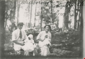
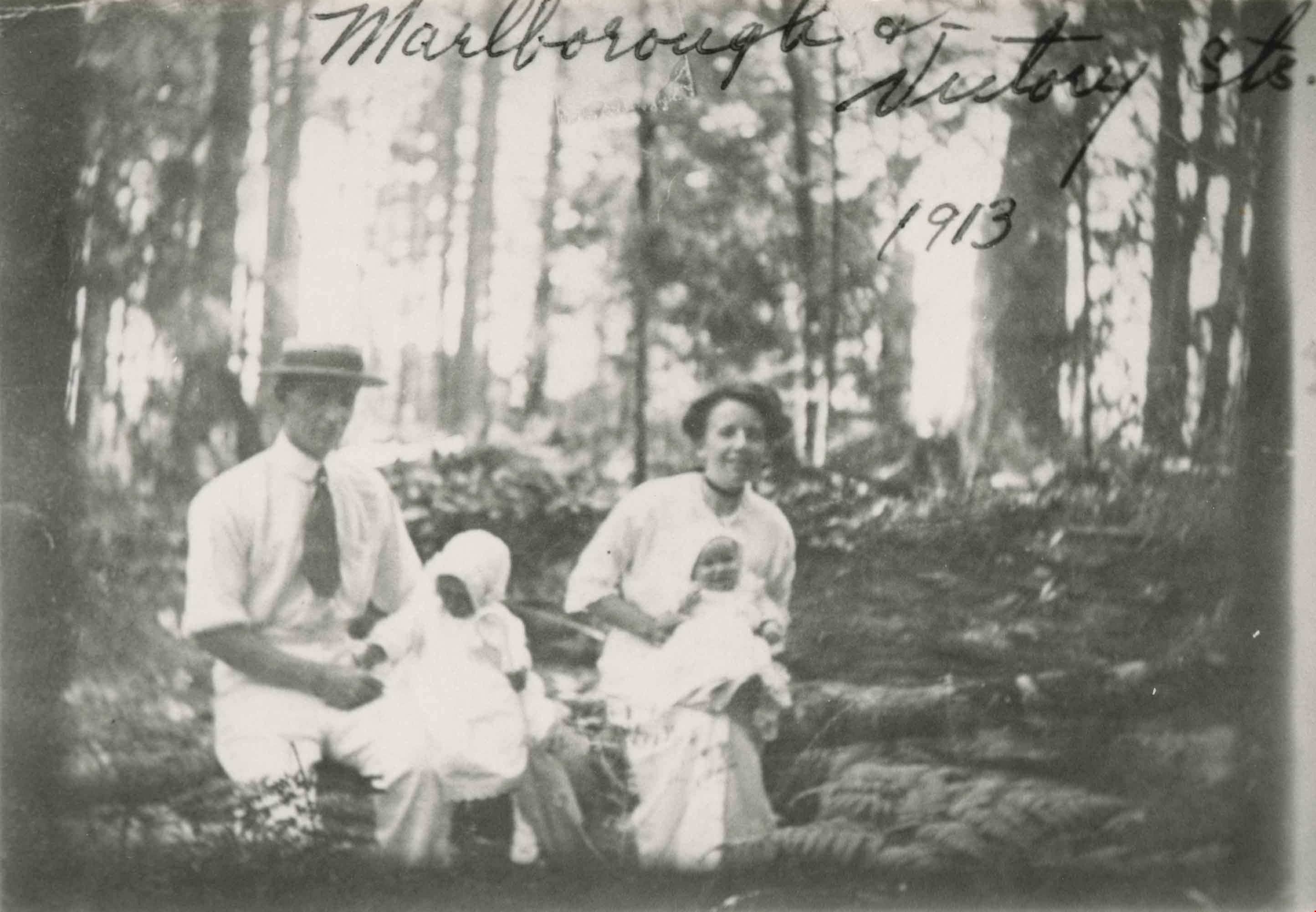
Family at Marlborough Avenue
https://search.heritageburnaby.ca/link/archivedescription35052
- Repository
- City of Burnaby Archives
- Date
- 1913 (date of original), copied 1986
- Collection/Fonds
- Burnaby Historical Society fonds
- Description Level
- Item
- Physical Description
- 1 photograph : b&w ; 8.7 x 12.7 cm print
- Scope and Content
- Photograph of an unidentified family at Marlborough Avenue and Victory Street. A man and woman are seated outside in a forested area holding two small children. An annotation at the top of photograph reads, "Marlborough & Victory Sts. 1913."
- Repository
- City of Burnaby Archives
- Date
- 1913 (date of original), copied 1986
- Collection/Fonds
- Burnaby Historical Society fonds
- Subseries
- Gough family subseries
- Physical Description
- 1 photograph : b&w ; 8.7 x 12.7 cm print
- Description Level
- Item
- Record No.
- 182-006
- Access Restriction
- No restrictions
- Reproduction Restriction
- No known restrictions
- Accession Number
- BHS1986-30
- Scope and Content
- Photograph of an unidentified family at Marlborough Avenue and Victory Street. A man and woman are seated outside in a forested area holding two small children. An annotation at the top of photograph reads, "Marlborough & Victory Sts. 1913."
- Subjects
- Geographic Features - Forests
- Media Type
- Photograph
- Notes
- Title based on contents of photograph
- Geographic Access
- Marlborough Avenue
- Victory Street
- Historic Neighbourhood
- Alta-Vista (Historic Neighbourhood)
- Planning Study Area
- Sussex-Nelson Area
Images
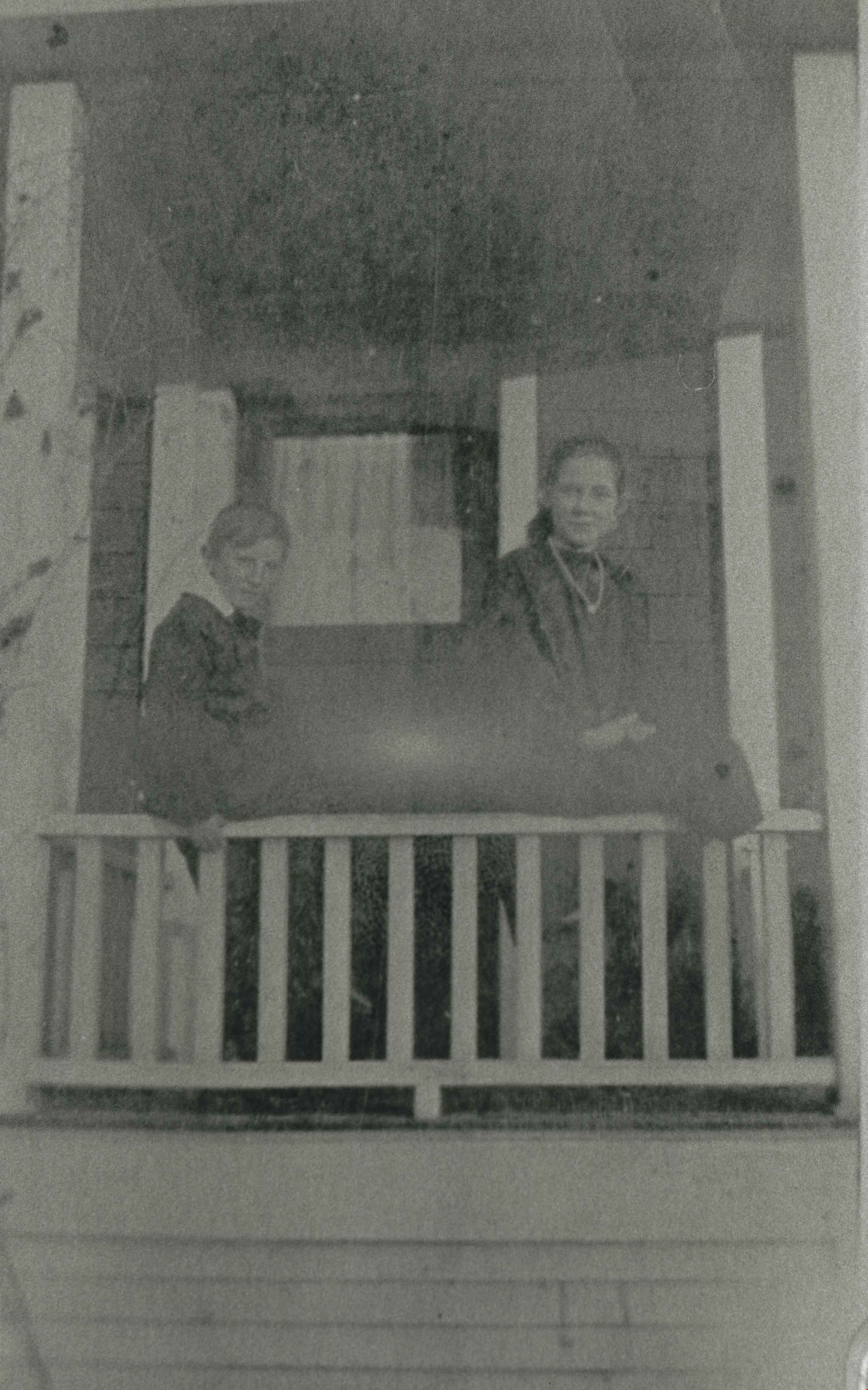
![Family gathering, [191-?] (date of original), copied 1991 thumbnail](/media/hpo/_Data/_Archives_Images/_Unrestricted/370/370-678.jpg?width=280)
Family gathering
https://search.heritageburnaby.ca/link/archivedescription38091
- Repository
- City of Burnaby Archives
- Date
- [191-?] (date of original), copied 1991
- Collection/Fonds
- Burnaby Historical Society fonds
- Description Level
- Item
- Physical Description
- 1 photograph : b&w ; 2.7 x 4.8 cm print on contact sheet 21.5 x 26.8 cm
- Scope and Content
- Photograph of a family gathering at house on Rumble Street. People are standing on the porch and stairs of the house.
- Repository
- City of Burnaby Archives
- Date
- [191-?] (date of original), copied 1991
- Collection/Fonds
- Burnaby Historical Society fonds
- Subseries
- Burnaby Image Bank subseries
- Physical Description
- 1 photograph : b&w ; 2.7 x 4.8 cm print on contact sheet 21.5 x 26.8 cm
- Description Level
- Item
- Record No.
- 370-678
- Access Restriction
- No restrictions
- Reproduction Restriction
- No restrictions
- Accession Number
- BHS1999-03
- Scope and Content
- Photograph of a family gathering at house on Rumble Street. People are standing on the porch and stairs of the house.
- Media Type
- Photograph
- Notes
- Title based on contents of photograph
- 1 b&w copy negative accompanying
- Negative has a pink cast
- Geographic Access
- Rumble Street
- Historic Neighbourhood
- Alta-Vista (Historic Neighbourhood)
- Planning Study Area
- Sussex-Nelson Area
Images
![Family gathering, [191-?] (date of original), copied 1991 thumbnail](/media/hpo/_Data/_Archives_Images/_Unrestricted/370/370-678.jpg)
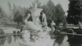
Fountain at Ocean View Cemetery
https://search.heritageburnaby.ca/link/archivedescription37829
- Repository
- City of Burnaby Archives
- Date
- 1944 (date of original), copied 1991
- Collection/Fonds
- Burnaby Historical Society fonds
- Description Level
- Item
- Physical Description
- 1 photograph : b&w ; 2.7 x 4.8 cm print on contact sheet 20.6 x 26.2 cm
- Scope and Content
- Photograph of a fountain in Ocean View Cemetery near Central Park. A woman is standing behind the fountain, and the design includes statues of birds.
- Repository
- City of Burnaby Archives
- Date
- 1944 (date of original), copied 1991
- Collection/Fonds
- Burnaby Historical Society fonds
- Subseries
- Burnaby Image Bank subseries
- Physical Description
- 1 photograph : b&w ; 2.7 x 4.8 cm print on contact sheet 20.6 x 26.2 cm
- Description Level
- Item
- Record No.
- 370-417
- Access Restriction
- No restrictions
- Reproduction Restriction
- No known restrictions
- Accession Number
- BHS1999-03
- Scope and Content
- Photograph of a fountain in Ocean View Cemetery near Central Park. A woman is standing behind the fountain, and the design includes statues of birds.
- Subjects
- Cemeteries
- Fountains
- Names
- Ocean View Burial Park
- Media Type
- Photograph
- Notes
- Title based on contents of photograph
- 1 b&w copy negative accompanying
- Negative has a pink cast
- Geographic Access
- Imperial Street
- Street Address
- 4000 Imperial Street
- Historic Neighbourhood
- Alta-Vista (Historic Neighbourhood)
- Planning Study Area
- Suncrest Area
Images

![Fred Holdsworth and his wife in front of their house, [1912] thumbnail](/media/hpo/_Data/_BVM_Images/1977/198000120001.jpg?width=280)
Fred Holdsworth and his wife in front of their house
https://search.heritageburnaby.ca/link/museumdescription3029
- Repository
- Burnaby Village Museum
- Date
- [1912]
- Collection/Fonds
- Burnaby Village Museum Photograph collection
- Description Level
- Item
- Physical Description
- 1 photograph : b&w postcard ; 13.9 x 8.5 cm
- Scope and Content
- Photographic postcard of Fred Holdsworth and his wife standing outside their Neville Street Home. The house is two storeys with an attic with windows. The porch is elevated with steep stairs leading to the front door, which is on the second floor. They are both standing with their hands on their hi…
- Repository
- Burnaby Village Museum
- Collection/Fonds
- Burnaby Village Museum Photograph collection
- Description Level
- Item
- Physical Description
- 1 photograph : b&w postcard ; 13.9 x 8.5 cm
- Scope and Content
- Photographic postcard of Fred Holdsworth and his wife standing outside their Neville Street Home. The house is two storeys with an attic with windows. The porch is elevated with steep stairs leading to the front door, which is on the second floor. They are both standing with their hands on their hips. There are variant spellings of "Holdsworth" used in the notes in the accession file. They are "Houldsworth" and "Hallsworth." The 1937 British Columbia directory lists a Fred Houldsworth at 3345 Neville Street, Burnaby. The address was later renumbered 5249 Neville Street.
- Geographic Access
- Neville Street
- Street Address
- 5249 Neville Street
- Accession Code
- HV980.12.1
- Access Restriction
- No restrictions
- Reproduction Restriction
- May be restricted by third party rights
- Date
- [1912]
- Media Type
- Photograph
- Historic Neighbourhood
- Alta-Vista (Historic Neighbourhood)
- Planning Study Area
- Clinton-Glenwood Area
- Scan Resolution
- 600
- Scan Date
- 2023-09-12
- Notes
- Title based on contents of photograph
Images
![Fred Holdsworth and his wife in front of their house, [1912] thumbnail](/media/hpo/_Data/_BVM_Images/1977/198000120001.jpg)
![Fredrick Le Grove, [192-] (date of original), copied 1986 thumbnail](/media/hpo/_Data/_Archives_Images/_Unrestricted/204/204-360.jpg?width=280)
Fredrick Le Grove
https://search.heritageburnaby.ca/link/archivedescription35502
- Repository
- City of Burnaby Archives
- Date
- [192-] (date of original), copied 1986
- Collection/Fonds
- Burnaby Historical Society fonds
- Description Level
- Item
- Physical Description
- 1 photograph : b&w ; 12.7 x 17.8 cm print
- Scope and Content
- Photograph of Frederick Le Grove in the front yard of his home at 3250 Neville Street (later renumbered 5422 Neville Street). In the background is the Boscott family home. Fredrick Le Grove was married to Ida Le Grove (nee Burlton) and lived here with his family.
- Repository
- City of Burnaby Archives
- Date
- [192-] (date of original), copied 1986
- Collection/Fonds
- Burnaby Historical Society fonds
- Subseries
- Pioneer Tales subseries
- Physical Description
- 1 photograph : b&w ; 12.7 x 17.8 cm print
- Description Level
- Item
- Record No.
- 204-360
- Access Restriction
- No restrictions
- Reproduction Restriction
- No known restrictions
- Accession Number
- BHS1988-03
- Scope and Content
- Photograph of Frederick Le Grove in the front yard of his home at 3250 Neville Street (later renumbered 5422 Neville Street). In the background is the Boscott family home. Fredrick Le Grove was married to Ida Le Grove (nee Burlton) and lived here with his family.
- Subjects
- Buildings - Residential - Houses
- Names
- Le Grove, Frederick
- Media Type
- Photograph
- Notes
- Title based on contents of photograph
- Geographic Access
- Neville Street
- Street Address
- 5422 Neville Street
- Historic Neighbourhood
- Alta-Vista (Historic Neighbourhood)
- Planning Study Area
- Clinton-Glenwood Area
Images
![Fredrick Le Grove, [192-] (date of original), copied 1986 thumbnail](/media/hpo/_Data/_Archives_Images/_Unrestricted/204/204-360.jpg)
![Gerry Herkel at St. Michael's Centre, [2002] thumbnail](/media/hpo/_Data/_Archives_Images/_Unrestricted/535/535-2328.jpg?width=280)
Gerry Herkel at St. Michael's Centre
https://search.heritageburnaby.ca/link/archivedescription96723
- Repository
- City of Burnaby Archives
- Date
- [2002]
- Collection/Fonds
- Burnaby NewsLeader photograph collection
- Description Level
- Item
- Physical Description
- 1 photograph (tiff) : col.
- Scope and Content
- Photograph of Gerry Herkel, the Executive Director of St. Michael's Centre, hugging the Shoppers Drug Mart mascot "Life Bear" outside of St. Michael's Centre as a promotion for their fundraising event.
- Repository
- City of Burnaby Archives
- Date
- [2002]
- Collection/Fonds
- Burnaby NewsLeader photograph collection
- Physical Description
- 1 photograph (tiff) : col.
- Description Level
- Item
- Record No.
- 535-2328
- Access Restriction
- No restrictions
- Reproduction Restriction
- No restrictions
- Accession Number
- 2018-12
- Scope and Content
- Photograph of Gerry Herkel, the Executive Director of St. Michael's Centre, hugging the Shoppers Drug Mart mascot "Life Bear" outside of St. Michael's Centre as a promotion for their fundraising event.
- Media Type
- Photograph
- Photographer
- Bartel, Mario
- Notes
- Title based on caption
- Collected by editorial for use in an April 2002 issue of the Burnaby NewsLeader
- Caption from metadata: "Gerry Herkel, the Executive Director of St. Michael's Centre Hospice, has a big hug for the Shoppers Drug Mart "Life Bear." Until May 18, the Shoppers Drug Mart stores in Burnaby and New Westminster will donate 10 cents to the Hospice for every Life Brand and Rialto product sold."
- Geographic Access
- Sussex Avenue
- Street Address
- 7451 Sussex Avenue
- Historic Neighbourhood
- Alta Vista (Historic Neighbourhood)
- Planning Study Area
- Sussex-Nelson Area
Images
![Gerry Herkel at St. Michael's Centre, [2002] thumbnail](/media/hpo/_Data/_Archives_Images/_Unrestricted/535/535-2328.jpg)
Gough children
https://search.heritageburnaby.ca/link/archivedescription35489
- Repository
- City of Burnaby Archives
- Date
- 1916 (date of original), copied 1986
- Collection/Fonds
- Burnaby Historical Society fonds
- Description Level
- Item
- Physical Description
- 1 photograph : b&w ; 12.7 x 17.8 cm print
- Scope and Content
- Photograph of (left) Leslie Gough and (right) Phyllis Gough, children of William and Agnes Gough, on the porch of of 2119 Nelson Avenue (later 7126 Nelson Avenue).
- Repository
- City of Burnaby Archives
- Date
- 1916 (date of original), copied 1986
- Collection/Fonds
- Burnaby Historical Society fonds
- Subseries
- Pioneer Tales subseries
- Physical Description
- 1 photograph : b&w ; 12.7 x 17.8 cm print
- Description Level
- Item
- Record No.
- 204-347
- Access Restriction
- No restrictions
- Reproduction Restriction
- No known restrictions
- Accession Number
- BHS1988-03
- Scope and Content
- Photograph of (left) Leslie Gough and (right) Phyllis Gough, children of William and Agnes Gough, on the porch of of 2119 Nelson Avenue (later 7126 Nelson Avenue).
- Names
- Gough, Leslie
- Gough, Phyllis
- Media Type
- Photograph
- Notes
- Title based on contents of photograph
- Geographic Access
- Nelson Avenue
- Street Address
- 7126 Nelson Avenue
- Historic Neighbourhood
- Alta-Vista (Historic Neighbourhood)
- Planning Study Area
- Sussex-Nelson Area
Images
![Gough family, [1916] (date of original), copied 1986 thumbnail](/media/hpo/_Data/_Archives_Images/_Unrestricted/204/204-017.jpg?width=280)
Gough family
https://search.heritageburnaby.ca/link/archivedescription35160
- Repository
- City of Burnaby Archives
- Date
- [1916] (date of original), copied 1986
- Collection/Fonds
- Burnaby Historical Society fonds
- Description Level
- Item
- Physical Description
- 1 photograph : b&w ; 12.7 x 17.8 cm print
- Scope and Content
- Photograph of the Gough family children in front of their Nelson Avenue home. Left to right: Dorothy Gough Love, Phyllis Gough and Donald Gough. The address on Nelson Avenue was later changed from 2119 to 7126.
- Repository
- City of Burnaby Archives
- Date
- [1916] (date of original), copied 1986
- Collection/Fonds
- Burnaby Historical Society fonds
- Subseries
- Pioneer Tales subseries
- Physical Description
- 1 photograph : b&w ; 12.7 x 17.8 cm print
- Description Level
- Item
- Record No.
- 204-017
- Access Restriction
- No restrictions
- Reproduction Restriction
- No known restrictions
- Accession Number
- BHS1988-03
- Scope and Content
- Photograph of the Gough family children in front of their Nelson Avenue home. Left to right: Dorothy Gough Love, Phyllis Gough and Donald Gough. The address on Nelson Avenue was later changed from 2119 to 7126.
- Media Type
- Photograph
- Notes
- Title based on contents of photograph
- Geographic Access
- Nelson Avenue
- Street Address
- 7126 Nelson Avenue
- Historic Neighbourhood
- Alta-Vista (Historic Neighbourhood)
- Planning Study Area
- Sussex-Nelson Area
Images
![Gough family, [1916] (date of original), copied 1986 thumbnail](/media/hpo/_Data/_Archives_Images/_Unrestricted/204/204-017.jpg)