![Shawn Wade in Big Bend, [2002] thumbnail](/media/hpo/_Data/_Archives_Images/_Unrestricted/535/535-2910.jpg?width=280)
Shawn Wade in Big Bend
https://search.heritageburnaby.ca/link/archivedescription97571
- Repository
- City of Burnaby Archives
- Date
- [2002]
- Collection/Fonds
- Burnaby NewsLeader photograph collection
- Description Level
- Item
- Physical Description
- 1 photograph (tiff) : col.
- Scope and Content
- Photograph of Shawn Wade standing on the shoulder of a road in the Big Bend area. A farm and forested area are visible in the background.
- Repository
- City of Burnaby Archives
- Date
- [2002]
- Collection/Fonds
- Burnaby NewsLeader photograph collection
- Physical Description
- 1 photograph (tiff) : col.
- Description Level
- Item
- Record No.
- 535-2910
- Access Restriction
- No restrictions
- Reproduction Restriction
- No restrictions
- Accession Number
- 2018-12
- Scope and Content
- Photograph of Shawn Wade standing on the shoulder of a road in the Big Bend area. A farm and forested area are visible in the background.
- Media Type
- Photograph
- Photographer
- Bartel, Mario
- Notes
- Title based on caption
- Collected by editorial for use in a January 2002 issue of the Burnaby NewsLeader
- Caption from metadata: "Shawn Wade fears the unique rural character of Burnaby's Big Bend area will die if Burnaby council approves a plan for commercial development."
- Historic Neighbourhood
- Fraser Arm (Historic Neighbourhood)
- Planning Study Area
- Big Bend Area
Images
![Shawn Wade in Big Bend, [2002] thumbnail](/media/hpo/_Data/_Archives_Images/_Unrestricted/535/535-2910.jpg)
![Big Bend flood, [1999] thumbnail](/media/hpo/_Data/_Archives_Images/_Unrestricted/535/535-3167-1.jpg?width=280)
Big Bend flood
https://search.heritageburnaby.ca/link/archivedescription98087
- Repository
- City of Burnaby Archives
- Date
- [1999]
- Collection/Fonds
- Burnaby NewsLeader photograph collection
- Description Level
- File
- Physical Description
- 3 photographs (tiff) : col.
- Scope and Content
- File contains photographs of unidentified people after a flood in the Big Bend area. Photographs depict a person standing in a farm field and adjusting a plant at Wing Wong's Nursery, and another person wearing a hard hat and posing with a construction vehicle.
- Repository
- City of Burnaby Archives
- Date
- [1999]
- Collection/Fonds
- Burnaby NewsLeader photograph collection
- Physical Description
- 3 photographs (tiff) : col.
- Description Level
- File
- Record No.
- 535-3167
- Access Restriction
- No restrictions
- Reproduction Restriction
- No restrictions
- Accession Number
- 2018-12
- Scope and Content
- File contains photographs of unidentified people after a flood in the Big Bend area. Photographs depict a person standing in a farm field and adjusting a plant at Wing Wong's Nursery, and another person wearing a hard hat and posing with a construction vehicle.
- Subjects
- Agriculture - Farms
- Buildings - Agricultural - Nurseries
- Construction Tools and Equipment
- Natural Phenomena - Floods
- Media Type
- Photograph
- Notes
- Title based on original file name
- Collected by editorial for use in a May 1999 issue of the Burnaby NewsLeader
- Geographic Access
- Marine Drive
- Street Address
- 4892 Marine Drive
- Historic Neighbourhood
- Fraser Arm (Historic Neighbourhood)
- Planning Study Area
- Big Bend Area
Images
![Big Bend flood, [1999] thumbnail](/media/hpo/_Data/_Archives_Images/_Unrestricted/535/535-3167-1.jpg)
![Stoney Creek student with a pumpkin, [1999] thumbnail](/media/hpo/_Data/_Archives_Images/_Unrestricted/535/535-3365.jpg?width=280)
Stoney Creek student with a pumpkin
https://search.heritageburnaby.ca/link/archivedescription98355
- Repository
- City of Burnaby Archives
- Date
- [1999]
- Collection/Fonds
- Burnaby NewsLeader photograph collection
- Description Level
- Item
- Physical Description
- 1 photograph (tiff) : col.
- Scope and Content
- Photograph of Stoney Creek Elementary School student Michael Cao holding a pumpkin and wearing a backpack while standing in the field of the Laity Pumpkin Farm in Maple Ridge.
- Repository
- City of Burnaby Archives
- Date
- [1999]
- Collection/Fonds
- Burnaby NewsLeader photograph collection
- Physical Description
- 1 photograph (tiff) : col.
- Description Level
- Item
- Record No.
- 535-3365
- Access Restriction
- No restrictions
- Reproduction Restriction
- No restrictions
- Accession Number
- 2018-12
- Scope and Content
- Photograph of Stoney Creek Elementary School student Michael Cao holding a pumpkin and wearing a backpack while standing in the field of the Laity Pumpkin Farm in Maple Ridge.
- Media Type
- Photograph
- Photographer
- Ray, Steve
- Notes
- Title based on caption
- Collected by editorial for use in an October 1999 issue of the Burnaby NewsLeader
- Caption from metadata: "Michael Cao from Stoney Creek Elementary carries his pumpkin across the field at the Laity pumpkin farm in Maple Ridge on Thursday morning."
Images
![Stoney Creek student with a pumpkin, [1999] thumbnail](/media/hpo/_Data/_Archives_Images/_Unrestricted/535/535-3365.jpg)

Construction of dykes on Nicomen Island
https://search.heritageburnaby.ca/link/archivedescription34330
- Repository
- City of Burnaby Archives
- Date
- 1927
- Collection/Fonds
- Burnaby Historical Society fonds
- Description Level
- Item
- Physical Description
- 1 photograph : sepia ; 5 x 13.5 cm on page 17.5 x 22.7 cm
- Scope and Content
- Photograph of a farm and field along the Fraser River next to dykes that are being built on Nicomen Island.
- Repository
- City of Burnaby Archives
- Date
- 1927
- Collection/Fonds
- Burnaby Historical Society fonds
- Subseries
- Peers family subseries
- Physical Description
- 1 photograph : sepia ; 5 x 13.5 cm on page 17.5 x 22.7 cm
- Description Level
- Item
- Record No.
- 020-037
- Access Restriction
- No restrictions
- Reproduction Restriction
- No known restrictions
- Accession Number
- BHS2007-04
- Scope and Content
- Photograph of a farm and field along the Fraser River next to dykes that are being built on Nicomen Island.
- Media Type
- Photograph
- Notes
- Title based on caption accompanying photograph
Images

![Jesse Love house, [1908] (date of original), copied [between 1975 and 1985] thumbnail](/media/hpo/_Data/_Archives_Images/_Unrestricted/001/021-001.jpg?width=280)
Jesse Love house
https://search.heritageburnaby.ca/link/archivedescription34497
- Repository
- City of Burnaby Archives
- Date
- [1908] (date of original), copied [between 1975 and 1985]
- Collection/Fonds
- Burnaby Historical Society fonds
- Description Level
- Item
- Physical Description
- 1 photograph : sepia ; 12.6 x 17.6 cm mounted on cardboard 13.5 x 18.8 cm
- Scope and Content
- Photograph of the Jesse Love house and family on Cumberland Road. Two women and four children are standing outside of the house. In 1988, this house was moved to the site of the Burnaby Village Museum at Deer Lake Avenue, where it remains today.
- Repository
- City of Burnaby Archives
- Date
- [1908] (date of original), copied [between 1975 and 1985]
- Collection/Fonds
- Burnaby Historical Society fonds
- Subseries
- Photographs subseries
- Physical Description
- 1 photograph : sepia ; 12.6 x 17.6 cm mounted on cardboard 13.5 x 18.8 cm
- Description Level
- Item
- Record No.
- 021-001
- Access Restriction
- No restrictions
- Reproduction Restriction
- No known restrictions
- Accession Number
- BHS2007-04
- Scope and Content
- Photograph of the Jesse Love house and family on Cumberland Road. Two women and four children are standing outside of the house. In 1988, this house was moved to the site of the Burnaby Village Museum at Deer Lake Avenue, where it remains today.
- Media Type
- Photograph
- Notes
- Title based on contents of photograph
- 1 b&w copy negative accompanying
- Geographic Access
- Cumberland Street
- Street Address
- 6501 Deer Lake Avenue
- Historic Neighbourhood
- East Burnaby (Historic Neighbourhood)
- Planning Study Area
- Cariboo-Armstrong Area
Images
![Jesse Love house, [1908] (date of original), copied [between 1975 and 1985] thumbnail](/media/hpo/_Data/_Archives_Images/_Unrestricted/001/021-001.jpg)

C.F. Sprott's house
https://search.heritageburnaby.ca/link/archivedescription34498
- Repository
- City of Burnaby Archives
- Date
- 1908
- Collection/Fonds
- Burnaby Historical Society fonds
- Description Level
- Item
- Physical Description
- 1 photograph : sepia ; 12.8 x 17.7 cm mounted on cardboard 14.8 x 19.7 cm
- Scope and Content
- Photograph of C.F. Sprott's House at Douglas Road and Norland Avenue. A unidentified man is standing on the porch steps.
- Repository
- City of Burnaby Archives
- Date
- 1908
- Collection/Fonds
- Burnaby Historical Society fonds
- Subseries
- Photographs subseries
- Physical Description
- 1 photograph : sepia ; 12.8 x 17.7 cm mounted on cardboard 14.8 x 19.7 cm
- Description Level
- Item
- Record No.
- 022-001
- Access Restriction
- No restrictions
- Reproduction Restriction
- No known restrictions
- Accession Number
- BHS2007-04
- Scope and Content
- Photograph of C.F. Sprott's House at Douglas Road and Norland Avenue. A unidentified man is standing on the porch steps.
- Media Type
- Photograph
- Photographer
- Cooksley, William Thomas
- Notes
- Title based on contents of photograph
- Annotation at bottom of photograph reads, "C.F. Sprott's Residence, Fruit Farm, Burnaby B.C."
- Annotation underneath photograph reads, "W.T. Cooksley, New Westminster, B.C."
- Geographic Access
- Douglas Road
- Norland Avenue
- Historic Neighbourhood
- Burnaby Lake (Historic Neighbourhood)
- Planning Study Area
- Ardingley-Sprott Area
Images

![W.H. Lewis farm, [1900] thumbnail](/media/hpo/_Data/_Archives_Images/_Unrestricted/001/022-002.jpg?width=280)
W.H. Lewis farm
https://search.heritageburnaby.ca/link/archivedescription34499
- Repository
- City of Burnaby Archives
- Date
- [1900]
- Collection/Fonds
- Burnaby Historical Society fonds
- Description Level
- Item
- Physical Description
- 1 photograph : sepia ; 12.6 x 17.7 cm mounted on cardboard 14.2 x 19.3 cm
- Scope and Content
- Photograph of W.H. Lewis' fruit farm with a man, three women and five children kneeling in a strawberry field. "Pioneer Tales" identifies them as William Lewis (foreground), three of his children, and hired help. A house can be seen in the background. The Lewis house was located on 4th Street.
- Repository
- City of Burnaby Archives
- Date
- [1900]
- Collection/Fonds
- Burnaby Historical Society fonds
- Subseries
- Photographs subseries
- Physical Description
- 1 photograph : sepia ; 12.6 x 17.7 cm mounted on cardboard 14.2 x 19.3 cm
- Description Level
- Item
- Record No.
- 022-002
- Access Restriction
- No restrictions
- Reproduction Restriction
- No known restrictions
- Accession Number
- BHS2007-04
- Scope and Content
- Photograph of W.H. Lewis' fruit farm with a man, three women and five children kneeling in a strawberry field. "Pioneer Tales" identifies them as William Lewis (foreground), three of his children, and hired help. A house can be seen in the background. The Lewis house was located on 4th Street.
- Media Type
- Photograph
- Photographer
- Cooksley, William Thomas
- Notes
- Title based on contents of photograph
- Annotation at bottom of photograph reads, "W.H. Lewis' Fruit Farm, Burnaby, B.C."
- Geographic Access
- 4th Street
- 18th Avenue
- Historic Neighbourhood
- East Burnaby (Historic Neighbourhood)
- Planning Study Area
- Second Street Area
Images
![W.H. Lewis farm, [1900] thumbnail](/media/hpo/_Data/_Archives_Images/_Unrestricted/001/022-002.jpg)
![Jesse Love's Fruit Farm, Burnaby, BC, [1900] thumbnail](/media/hpo/_Data/_Archives_Images/_Unrestricted/001/022-004.jpg?width=280)
Jesse Love's Fruit Farm, Burnaby, BC
https://search.heritageburnaby.ca/link/archivedescription34501
- Repository
- City of Burnaby Archives
- Date
- [1900]
- Collection/Fonds
- Burnaby Historical Society fonds
- Description Level
- Item
- Physical Description
- 1 photograph : sepia ; 12.8 x 17.8 cm mounted on cardboard 14.7 x 19.8 cm
- Scope and Content
- Photograph of members of the Love family kneeling in a strawberry field. Left to right: Jesse Love (father), Leonard, Phoebe, Martha, Minnie, Martha Love (mother), and Sarah. The small building at the extreme left of the picture was George Love's (oldest of the Love's children) first sash and doo…
- Repository
- City of Burnaby Archives
- Date
- [1900]
- Collection/Fonds
- Burnaby Historical Society fonds
- Subseries
- Photographs subseries
- Physical Description
- 1 photograph : sepia ; 12.8 x 17.8 cm mounted on cardboard 14.7 x 19.8 cm
- Description Level
- Item
- Record No.
- 022-004
- Access Restriction
- No restrictions
- Reproduction Restriction
- No known restrictions
- Accession Number
- BHS2007-04
- Scope and Content
- Photograph of members of the Love family kneeling in a strawberry field. Left to right: Jesse Love (father), Leonard, Phoebe, Martha, Minnie, Martha Love (mother), and Sarah. The small building at the extreme left of the picture was George Love's (oldest of the Love's children) first sash and door outlet. He later built Love's Sash and Door Factory on the south side of Edmonds Street just west of 6th Street. The original farm was located in East Burnaby, on Cumberland Road. In 1988, this house was moved to the site of the Burnaby Village Museum at Deer Lake Avenue.
- Names
- Love, Jesse, 1849-1928
- Love, Leonard
- Brandrith, Martha Dorothy “Dot” Love
- Love, Martha Leonard, 1858-1920
- McKenzie, Edith Minnie Love
- Feedham, Phoebe Leonard Love
- Parker, Sarah Maria Love
- Media Type
- Photograph
- Photographer
- Cooksley, William Thomas
- Notes
- Annotation bottom of the photograph reads, "Jesse Love's Fruit Farm, Burnaby, BC"
- Geographic Access
- Cumberland Street
- Street Address
- 6501 Deer Lake Avenue
- Historic Neighbourhood
- East Burnaby (Historic Neighbourhood)
- Planning Study Area
- Cariboo-Armstrong Area
Images
![Jesse Love's Fruit Farm, Burnaby, BC, [1900] thumbnail](/media/hpo/_Data/_Archives_Images/_Unrestricted/001/022-004.jpg)
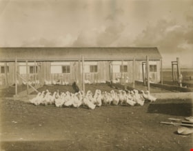
Poultry farm
https://search.heritageburnaby.ca/link/archivedescription34505
- Repository
- City of Burnaby Archives
- Date
- 1930
- Collection/Fonds
- Burnaby Historical Society fonds
- Description Level
- Item
- Physical Description
- 1 photograph : b&w ; 20.3 x 25.5 cm print
- Scope and Content
- Photograph of an unidentified poultry farm. A group of ducks is in front of a fence, and chickens are in pens are behind them.
- Repository
- City of Burnaby Archives
- Date
- 1930
- Collection/Fonds
- Burnaby Historical Society fonds
- Subseries
- Photographs subseries
- Physical Description
- 1 photograph : b&w ; 20.3 x 25.5 cm print
- Description Level
- Item
- Record No.
- 026-001
- Access Restriction
- No restrictions
- Reproduction Restriction
- No known restrictions
- Accession Number
- BHS2007-04
- Scope and Content
- Photograph of an unidentified poultry farm. A group of ducks is in front of a fence, and chickens are in pens are behind them.
- Subjects
- Agriculture - Farms
- Animals - Poultry
- Media Type
- Photograph
- Notes
- Title based on contents of photograph
Images


George Edmonds' poultry ranch
https://search.heritageburnaby.ca/link/archivedescription34550
- Repository
- City of Burnaby Archives
- Date
- 1914
- Collection/Fonds
- Burnaby Historical Society fonds
- Description Level
- Item
- Physical Description
- 1 photograph : b&w ; 16.1 x 21.3 cm mounted on 25.2 x 30.2 cm cardboard
- Scope and Content
- Photograph of George Edmonds poultry ranch with a number of chickens in a yard in front of a henhouse.
- Repository
- City of Burnaby Archives
- Date
- 1914
- Collection/Fonds
- Burnaby Historical Society fonds
- Subseries
- Photographs subseries
- Physical Description
- 1 photograph : b&w ; 16.1 x 21.3 cm mounted on 25.2 x 30.2 cm cardboard
- Description Level
- Item
- Record No.
- 044-010
- Access Restriction
- No restrictions
- Reproduction Restriction
- No known restrictions
- Accession Number
- BHS2007-04
- Scope and Content
- Photograph of George Edmonds poultry ranch with a number of chickens in a yard in front of a henhouse.
- Subjects
- Agriculture - Farms
- Animals - Poultry
- Media Type
- Photograph
- Notes
- Title based on contents of photograph
Images

![Oakalla Prison farm, [195-] (date of original), copied 1985 thumbnail](/media/hpo/_Data/_Archives_Images/_Unrestricted/126/134-009.jpg?width=280)
Oakalla Prison farm
https://search.heritageburnaby.ca/link/archivedescription34793
- Repository
- City of Burnaby Archives
- Date
- [195-] (date of original), copied 1985
- Collection/Fonds
- Burnaby Historical Society fonds
- Description Level
- Item
- Physical Description
- 1 photograph : b&w ; 8.8 x 12.0 cm print
- Scope and Content
- Photograph of the exterior of farm buildings and the road to the equipment shed at Oakalla Prison Farm.
- Repository
- City of Burnaby Archives
- Date
- [195-] (date of original), copied 1985
- Collection/Fonds
- Burnaby Historical Society fonds
- Physical Description
- 1 photograph : b&w ; 8.8 x 12.0 cm print
- Description Level
- Item
- Record No.
- 134-009
- Access Restriction
- No restrictions
- Reproduction Restriction
- Reproduce for fair dealing purposes only
- Accession Number
- BHS1985-02
- Scope and Content
- Photograph of the exterior of farm buildings and the road to the equipment shed at Oakalla Prison Farm.
- Names
- Oakalla Prison Farm
- Media Type
- Photograph
- Notes
- Title based on contents of photograph
- Geographic Access
- Oakmount Crescent
- Street Address
- 5220 Oakmount Crescent
- Historic Neighbourhood
- Burnaby Lake (Historic Neighbourhood)
- Planning Study Area
- Oakalla Area
Images
![Oakalla Prison farm, [195-] (date of original), copied 1985 thumbnail](/media/hpo/_Data/_Archives_Images/_Unrestricted/126/134-009.jpg)
![Oakalla Prison Farm, [195-] (date of original), copied 1985 thumbnail](/media/hpo/_Data/_Archives_Images/_Unrestricted/126/134-012.jpg?width=280)
Oakalla Prison Farm
https://search.heritageburnaby.ca/link/archivedescription34796
- Repository
- City of Burnaby Archives
- Date
- [195-] (date of original), copied 1985
- Collection/Fonds
- Burnaby Historical Society fonds
- Description Level
- Item
- Physical Description
- 1 photograph : b&w ; 8.8 x 12.1 cm print
- Scope and Content
- Photograph of the exterior of farm buildings and the shop/repairs buildings at Oakalla Prison Farm.
- Repository
- City of Burnaby Archives
- Date
- [195-] (date of original), copied 1985
- Collection/Fonds
- Burnaby Historical Society fonds
- Physical Description
- 1 photograph : b&w ; 8.8 x 12.1 cm print
- Description Level
- Item
- Record No.
- 134-012
- Access Restriction
- No restrictions
- Reproduction Restriction
- Reproduce for fair dealing purposes only
- Accession Number
- BHS1985-02
- Scope and Content
- Photograph of the exterior of farm buildings and the shop/repairs buildings at Oakalla Prison Farm.
- Names
- Oakalla Prison Farm
- Media Type
- Photograph
- Notes
- Title based on contents of photograph
- Geographic Access
- Oakmount Crescent
- Street Address
- 5220 Oakmount Crescent
- Historic Neighbourhood
- Burnaby Lake (Historic Neighbourhood)
- Planning Study Area
- Oakalla Area
Images
![Oakalla Prison Farm, [195-] (date of original), copied 1985 thumbnail](/media/hpo/_Data/_Archives_Images/_Unrestricted/126/134-012.jpg)
![Oakalla Prison Farm, [195-] (date of original), copied 1985 thumbnail](/media/hpo/_Data/_Archives_Images/_Unrestricted/126/134-013.jpg?width=280)
Oakalla Prison Farm
https://search.heritageburnaby.ca/link/archivedescription34797
- Repository
- City of Burnaby Archives
- Date
- [195-] (date of original), copied 1985
- Collection/Fonds
- Burnaby Historical Society fonds
- Description Level
- Item
- Physical Description
- 1 photograph : b&w ; 8.8 x 12.6 cm print
- Scope and Content
- Photograph of the exterior of farm buildings and the equipment shed at Oakalla Prison Farm.
- Repository
- City of Burnaby Archives
- Date
- [195-] (date of original), copied 1985
- Collection/Fonds
- Burnaby Historical Society fonds
- Physical Description
- 1 photograph : b&w ; 8.8 x 12.6 cm print
- Description Level
- Item
- Record No.
- 134-013
- Access Restriction
- No restrictions
- Reproduction Restriction
- Reproduce for fair dealing purposes only
- Accession Number
- BHS1985-02
- Scope and Content
- Photograph of the exterior of farm buildings and the equipment shed at Oakalla Prison Farm.
- Names
- Oakalla Prison Farm
- Media Type
- Photograph
- Notes
- Title based on contents of photograph
- Geographic Access
- Oakmount Crescent
- Street Address
- 5220 Oakmount Crescent
- Historic Neighbourhood
- Burnaby Lake (Historic Neighbourhood)
- Planning Study Area
- Oakalla Area
Images
![Oakalla Prison Farm, [195-] (date of original), copied 1985 thumbnail](/media/hpo/_Data/_Archives_Images/_Unrestricted/126/134-013.jpg)
![Oakalla Prison Farm, [195-] (date of original), copied 1985 thumbnail](/media/hpo/_Data/_Archives_Images/_Unrestricted/126/134-015.jpg?width=280)
Oakalla Prison Farm
https://search.heritageburnaby.ca/link/archivedescription34799
- Repository
- City of Burnaby Archives
- Date
- [195-] (date of original), copied 1985
- Collection/Fonds
- Burnaby Historical Society fonds
- Description Level
- Item
- Physical Description
- 1 photograph : b&w ; 8.8 x 11.9 cm print
- Scope and Content
- Photograph of Oakalla Prison Farm taken from the main building and looking northeast.
- Repository
- City of Burnaby Archives
- Date
- [195-] (date of original), copied 1985
- Collection/Fonds
- Burnaby Historical Society fonds
- Physical Description
- 1 photograph : b&w ; 8.8 x 11.9 cm print
- Description Level
- Item
- Record No.
- 134-015
- Access Restriction
- No restrictions
- Reproduction Restriction
- Reproduce for fair dealing purposes only
- Accession Number
- BHS1985-02
- Scope and Content
- Photograph of Oakalla Prison Farm taken from the main building and looking northeast.
- Names
- Oakalla Prison Farm
- Media Type
- Photograph
- Notes
- Title based on contents of photograph
- Geographic Access
- Oakmount Crescent
- Street Address
- 5220 Oakmount Crescent
- Historic Neighbourhood
- Burnaby Lake (Historic Neighbourhood)
- Planning Study Area
- Oakalla Area
Images
![Oakalla Prison Farm, [195-] (date of original), copied 1985 thumbnail](/media/hpo/_Data/_Archives_Images/_Unrestricted/126/134-015.jpg)
![Oakalla Prison Farm, [195-] (date of original), copied 1985 thumbnail](/media/hpo/_Data/_Archives_Images/_Unrestricted/126/134-016.jpg?width=280)
Oakalla Prison Farm
https://search.heritageburnaby.ca/link/archivedescription34800
- Repository
- City of Burnaby Archives
- Date
- [195-] (date of original), copied 1985
- Collection/Fonds
- Burnaby Historical Society fonds
- Description Level
- Item
- Physical Description
- 1 photograph : b&w ; 8.8 x 12.0 cm
- Scope and Content
- Photograph of Oakalla Prison Farm taken from the main building and looking northeast. Deer Lake can be seen in the background.
- Repository
- City of Burnaby Archives
- Date
- [195-] (date of original), copied 1985
- Collection/Fonds
- Burnaby Historical Society fonds
- Physical Description
- 1 photograph : b&w ; 8.8 x 12.0 cm
- Description Level
- Item
- Record No.
- 134-016
- Access Restriction
- No restrictions
- Reproduction Restriction
- Reproduce for fair dealing purposes only
- Accession Number
- BHS1985-02
- Scope and Content
- Photograph of Oakalla Prison Farm taken from the main building and looking northeast. Deer Lake can be seen in the background.
- Subjects
- Agriculture - Farms
- Buildings - Public - Detention Facilities
- Geographic Features - Lakes and Ponds
- Names
- Oakalla Prison Farm
- Media Type
- Photograph
- Notes
- Title based on contents of photograph
- Geographic Access
- Deer Lake
- Oakmount Crescent
- Street Address
- 5220 Oakmount Crescent
- Historic Neighbourhood
- Burnaby Lake (Historic Neighbourhood)
- Planning Study Area
- Oakalla Area
Images
![Oakalla Prison Farm, [195-] (date of original), copied 1985 thumbnail](/media/hpo/_Data/_Archives_Images/_Unrestricted/126/134-016.jpg)
![Oakalla Prison Farm, [195-] (date of original), copied 1985 thumbnail](/media/hpo/_Data/_Archives_Images/_Unrestricted/126/134-017.jpg?width=280)
Oakalla Prison Farm
https://search.heritageburnaby.ca/link/archivedescription34801
- Repository
- City of Burnaby Archives
- Date
- [195-] (date of original), copied 1985
- Collection/Fonds
- Burnaby Historical Society fonds
- Description Level
- Item
- Physical Description
- 1 photograph : b&w ; 8.8 x 12.2 cm
- Scope and Content
- Photograph of Oakalla Prison Farm taken from the main building and looking southeast. Deer Lake can be seen in the background.
- Repository
- City of Burnaby Archives
- Date
- [195-] (date of original), copied 1985
- Collection/Fonds
- Burnaby Historical Society fonds
- Physical Description
- 1 photograph : b&w ; 8.8 x 12.2 cm
- Description Level
- Item
- Record No.
- 134-017
- Access Restriction
- No restrictions
- Reproduction Restriction
- Reproduce for fair dealing purposes only
- Accession Number
- BHS1985-02
- Scope and Content
- Photograph of Oakalla Prison Farm taken from the main building and looking southeast. Deer Lake can be seen in the background.
- Subjects
- Agriculture - Farms
- Buildings - Public - Detention Facilities
- Geographic Features - Lakes and Ponds
- Names
- Oakalla Prison Farm
- Media Type
- Photograph
- Notes
- Title based on contents of photograph
- Geographic Access
- Deer Lake
- Oakmount Crescent
- Street Address
- 5220 Oakmount Crescent
- Historic Neighbourhood
- Burnaby Lake (Historic Neighbourhood)
- Planning Study Area
- Oakalla Area
Images
![Oakalla Prison Farm, [195-] (date of original), copied 1985 thumbnail](/media/hpo/_Data/_Archives_Images/_Unrestricted/126/134-017.jpg)
![Oakalla Prison Farm, [195-] (date of original), copied 1985 thumbnail](/media/hpo/_Data/_Archives_Images/_Unrestricted/126/134-018.jpg?width=280)
Oakalla Prison Farm
https://search.heritageburnaby.ca/link/archivedescription34802
- Repository
- City of Burnaby Archives
- Date
- [195-] (date of original), copied 1985
- Collection/Fonds
- Burnaby Historical Society fonds
- Description Level
- Item
- Physical Description
- 1 photograph : b&w ; 8.8 x 12.0 cm
- Scope and Content
- Photograph of Oakalla Prison Farm taken from the main building and looking southeast. Deer Lake can be seen in the background.
- Repository
- City of Burnaby Archives
- Date
- [195-] (date of original), copied 1985
- Collection/Fonds
- Burnaby Historical Society fonds
- Physical Description
- 1 photograph : b&w ; 8.8 x 12.0 cm
- Description Level
- Item
- Record No.
- 134-018
- Access Restriction
- No restrictions
- Reproduction Restriction
- Reproduce for fair dealing purposes only
- Accession Number
- BHS1985-02
- Scope and Content
- Photograph of Oakalla Prison Farm taken from the main building and looking southeast. Deer Lake can be seen in the background.
- Subjects
- Agriculture - Farms
- Buildings - Public - Detention Facilities
- Geographic Features - Lakes and Ponds
- Names
- Oakalla Prison Farm
- Media Type
- Photograph
- Notes
- Title based on contents of photograph
- Geographic Access
- Deer Lake
- Oakmount Crescent
- Street Address
- 5220 Oakmount Crescent
- Historic Neighbourhood
- Burnaby Lake (Historic Neighbourhood)
- Planning Study Area
- Oakalla Area
Images
![Oakalla Prison Farm, [195-] (date of original), copied 1985 thumbnail](/media/hpo/_Data/_Archives_Images/_Unrestricted/126/134-018.jpg)
![William Brenchley farm, [between 1890 and 1895] (date of original), copied 1985 thumbnail](/media/hpo/_Data/_Archives_Images/_Unrestricted/126/146-002.jpg?width=280)
William Brenchley farm
https://search.heritageburnaby.ca/link/archivedescription34864
- Repository
- City of Burnaby Archives
- Date
- [between 1890 and 1895] (date of original), copied 1985
- Collection/Fonds
- Burnaby Historical Society fonds
- Description Level
- Item
- Physical Description
- 1 photograph : b&w ; 8.8 x 12.5 cm print
- Scope and Content
- Photograph of a farm hand and horse team inside a large stump, taken on William Brenchley's farm. The farm was located at the northeast corner of Kingsway and 10th Avenue.
- Repository
- City of Burnaby Archives
- Date
- [between 1890 and 1895] (date of original), copied 1985
- Collection/Fonds
- Burnaby Historical Society fonds
- Subseries
- W.E. Brenchley subseries
- Physical Description
- 1 photograph : b&w ; 8.8 x 12.5 cm print
- Description Level
- Item
- Record No.
- 146-002
- Access Restriction
- No restrictions
- Reproduction Restriction
- No known restrictions
- Accession Number
- BHS1985-16
- Scope and Content
- Photograph of a farm hand and horse team inside a large stump, taken on William Brenchley's farm. The farm was located at the northeast corner of Kingsway and 10th Avenue.
- Media Type
- Photograph
- Photographer
- Thompson, S.J.
- Notes
- Title based on contents of photograph
- Geographic Access
- 10th Avenue
- Kingsway
- Historic Neighbourhood
- Edmonds (Historic Neighbourhood)
- Planning Study Area
- Edmonds Area
Images
![William Brenchley farm, [between 1890 and 1895] (date of original), copied 1985 thumbnail](/media/hpo/_Data/_Archives_Images/_Unrestricted/126/146-002.jpg)
![Oakalla Prison Farm, [193-] (date of original), copied 1986 thumbnail](/media/hpo/_Data/_Archives_Images/_Unrestricted/126/179-003.jpg?width=280)
Oakalla Prison Farm
https://search.heritageburnaby.ca/link/archivedescription35032
- Repository
- City of Burnaby Archives
- Date
- [193-] (date of original), copied 1986
- Collection/Fonds
- Burnaby Historical Society fonds
- Description Level
- Item
- Physical Description
- 1 photograph : b&w ; 12.6 x 8.8 cm print
- Scope and Content
- Photograph of pigs outside at Oakalla Prison Farm. Deer Lake can be seen in the background.
- Repository
- City of Burnaby Archives
- Date
- [193-] (date of original), copied 1986
- Collection/Fonds
- Burnaby Historical Society fonds
- Subseries
- Chamberlain family subseries
- Physical Description
- 1 photograph : b&w ; 12.6 x 8.8 cm print
- Description Level
- Item
- Record No.
- 179-003
- Access Restriction
- No restrictions
- Reproduction Restriction
- No known restrictions
- Accession Number
- BHS1986-27
- Scope and Content
- Photograph of pigs outside at Oakalla Prison Farm. Deer Lake can be seen in the background.
- Names
- Oakalla Prison Farm
- Media Type
- Photograph
- Notes
- Title based on contents of photograph
- Geographic Access
- Oakmount Crescent
- Deer Lake
- Street Address
- 5220 Oakmount Crescent
- Historic Neighbourhood
- Burnaby Lake (Historic Neighbourhood)
- Planning Study Area
- Oakalla Area
Images
![Oakalla Prison Farm, [193-] (date of original), copied 1986 thumbnail](/media/hpo/_Data/_Archives_Images/_Unrestricted/126/179-003.jpg)
![Elgin Avenue farmhouse, [between 1920 and 1925] (date of original), copied 1986 thumbnail](/media/hpo/_Data/_Archives_Images/_Unrestricted/126/179-005.jpg?width=280)
Elgin Avenue farmhouse
https://search.heritageburnaby.ca/link/archivedescription35034
- Repository
- City of Burnaby Archives
- Date
- [between 1920 and 1925] (date of original), copied 1986
- Collection/Fonds
- Burnaby Historical Society fonds
- Description Level
- Item
- Physical Description
- 1 photograph : b&w ; 8.7 x 12.7 cm print
- Scope and Content
- Photograph of the exterior of an Elgin Avenue farmhouse and surrounding property. The farmhouse is at the left side of the photograph, and a chicken barn is at the right side. This may be 6389 Elgin Avenue.
- Repository
- City of Burnaby Archives
- Date
- [between 1920 and 1925] (date of original), copied 1986
- Collection/Fonds
- Burnaby Historical Society fonds
- Subseries
- Chamberlain family subseries
- Physical Description
- 1 photograph : b&w ; 8.7 x 12.7 cm print
- Description Level
- Item
- Record No.
- 179-005
- Access Restriction
- No restrictions
- Reproduction Restriction
- No known restrictions
- Accession Number
- BHS1986-27
- Scope and Content
- Photograph of the exterior of an Elgin Avenue farmhouse and surrounding property. The farmhouse is at the left side of the photograph, and a chicken barn is at the right side. This may be 6389 Elgin Avenue.
- Media Type
- Photograph
- Notes
- Title based on contents of photograph
- Geographic Access
- Elgin Avenue
- Street Address
- 6389 Elgin Avenue
- Historic Neighbourhood
- Central Park (Historic Neighbourhood)
- Planning Study Area
- Windsor Area
Images
![Elgin Avenue farmhouse, [between 1920 and 1925] (date of original), copied 1986 thumbnail](/media/hpo/_Data/_Archives_Images/_Unrestricted/126/179-005.jpg)