Narrow Results By
Allan Amundsen collection
https://search.heritageburnaby.ca/link/archivedescription84878
- Repository
- City of Burnaby Archives
- Date
- 1960-1964
- Collection/Fonds
- Allan Amundsen collection
- Description Level
- Fonds
- Physical Description
- 38 photographs : b&w ; 22.5 x 22.5 cm + 1 photograph : b&w (lasercopy) + 1 p. of textual records
- Scope and Content
- Fonds comprises aerial photographs and related material used as teaching aids for Geography 12 night school classes at Burnaby Central School. Aerial photographs were taken on the same flight path causing an overlapping of images in most cases to the east or the west.
- Repository
- City of Burnaby Archives
- Date
- 1960-1964
- Collection/Fonds
- Allan Amundsen collection
- Physical Description
- 38 photographs : b&w ; 22.5 x 22.5 cm + 1 photograph : b&w (lasercopy) + 1 p. of textual records
- Description Level
- Fonds
- Access Restriction
- In Archives only
- Reproduction Restriction
- No reproduction permitted
- Accession Number
- 2014-08
- Scope and Content
- Fonds comprises aerial photographs and related material used as teaching aids for Geography 12 night school classes at Burnaby Central School. Aerial photographs were taken on the same flight path causing an overlapping of images in most cases to the east or the west.
- History
- Allan Amundsen was born in South Burnaby, graduated from Burnaby North Secondary School in 1966 and moved later to Sullivan Heights. Allan was a secondary school teacher who began his teaching career in 1972 and taught at Kitslano, David Thompson, Burnaby Central and night school from 1977- 2011.
- Media Type
- Textual Record
- Photograph
- Creator
- Amundsen, Allan
- Notes
- Title based on contents of fonds
- Photo catalogue 561, MSS178
Boundary Road
https://search.heritageburnaby.ca/link/archivedescription79989
- Repository
- City of Burnaby Archives
- Date
- October, 1976
- Collection/Fonds
- Burnaby Public Library Contemporary Visual Archive Project
- Description Level
- Item
- Physical Description
- 1 photograph : b&w ; 11 x 16 cm mounted on cardboard
- Scope and Content
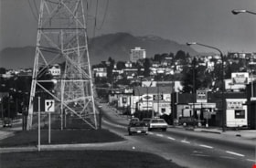
- Photograph shows view of Boundary Road and the North Shore mountains from 1st Avenue.
- Repository
- City of Burnaby Archives
- Date
- October, 1976
- Collection/Fonds
- Burnaby Public Library Contemporary Visual Archive Project
- Physical Description
- 1 photograph : b&w ; 11 x 16 cm mounted on cardboard
- Description Level
- Item
- Record No.
- 556-545
- Access Restriction
- No restrictions
- Reproduction Restriction
- Reproduce for fair dealing purposes only
- Accession Number
- 2013-13
- Scope and Content
- Photograph shows view of Boundary Road and the North Shore mountains from 1st Avenue.
- Subjects
- Aerial Photographs
- Media Type
- Photograph
- Photographer
- Cook, Alan
- Notes
- Scope note taken directly from BPL photograph description.
- 1 b&w copy negative : 10 x 12.5 cm accompanying
- Geographic Access
- Boundary Road
- Historic Neighbourhood
- Broadview (Historic Neighbourhood)
- Planning Study Area
- West Central Valley Area
Images
Hastings Street
https://search.heritageburnaby.ca/link/archivedescription79969
- Repository
- City of Burnaby Archives
- Date
- October, 1976
- Collection/Fonds
- Burnaby Public Library Contemporary Visual Archive Project
- Description Level
- Item
- Physical Description
- 1 photograph : b&w ; 11 x 16 cm mounted on cardboard
- Scope and Content
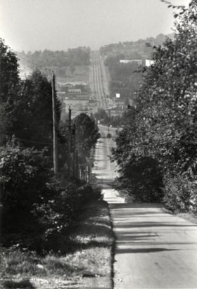
- Photograph shows a view of Hastings Street looking west from the end of Hastings Street on Burnaby Mountain.
- Repository
- City of Burnaby Archives
- Date
- October, 1976
- Collection/Fonds
- Burnaby Public Library Contemporary Visual Archive Project
- Physical Description
- 1 photograph : b&w ; 11 x 16 cm mounted on cardboard
- Description Level
- Item
- Record No.
- 556-532
- Access Restriction
- No restrictions
- Reproduction Restriction
- Reproduce for fair dealing purposes only
- Accession Number
- 2013-13
- Scope and Content
- Photograph shows a view of Hastings Street looking west from the end of Hastings Street on Burnaby Mountain.
- Subjects
- Aerial Photographs
- Media Type
- Photograph
- Photographer
- Cook, Alan
- Notes
- Scope note taken directly from BPL photograph description.
- 1 b&w copy negative : 10 x 12.5 cm accompanying
- Geographic Access
- Hastings Street
- Planning Study Area
- Burnaby Mountain Area
Images
Hastings Street
https://search.heritageburnaby.ca/link/archivedescription79980
- Repository
- City of Burnaby Archives
- Date
- October, 1976
- Collection/Fonds
- Burnaby Public Library Contemporary Visual Archive Project
- Description Level
- Item
- Physical Description
- 1 photograph : b&w ; 11 x 16 cm mounted on cardboard
- Scope and Content
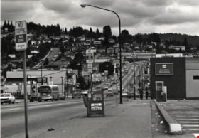
- Photograph shows view of Hastings Street looking east from Rosser Avenue toward Capitol Hill.
- Repository
- City of Burnaby Archives
- Date
- October, 1976
- Collection/Fonds
- Burnaby Public Library Contemporary Visual Archive Project
- Physical Description
- 1 photograph : b&w ; 11 x 16 cm mounted on cardboard
- Description Level
- Item
- Record No.
- 556-536
- Access Restriction
- No restrictions
- Reproduction Restriction
- Reproduce for fair dealing purposes only
- Accession Number
- 2013-13
- Scope and Content
- Photograph shows view of Hastings Street looking east from Rosser Avenue toward Capitol Hill.
- Subjects
- Aerial Photographs
- Media Type
- Photograph
- Photographer
- Cook, Alan
- Notes
- Scope note taken directly from BPL photograph description.
- 1 b&w copy negative : 10 x 12.5 cm accompanying
- Geographic Access
- Hastings Street
- Historic Neighbourhood
- Vancouver Heights (Historic Neighbourhood)
- Planning Study Area
- Burnaby Heights Area
Images
Vancouver, from Burnaby Heights
https://search.heritageburnaby.ca/link/archivedescription78862
- Repository
- City of Burnaby Archives
- Date
- October, 1976
- Collection/Fonds
- Burnaby Public Library Contemporary Visual Archive Project
- Description Level
- Item
- Physical Description
- 1 photograph : b&w ; 11 x 16 cm mounted on cardboard
- Scope and Content
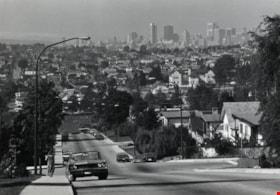
- Photograph is an aerial view of Vancouver, looking west from the area of Parker Street and Gilmore Avenue with western Burnaby in the foreground.
- Repository
- City of Burnaby Archives
- Date
- October, 1976
- Collection/Fonds
- Burnaby Public Library Contemporary Visual Archive Project
- Physical Description
- 1 photograph : b&w ; 11 x 16 cm mounted on cardboard
- Description Level
- Item
- Record No.
- 556-008
- Access Restriction
- No restrictions
- Reproduction Restriction
- Reproduce for fair dealing purposes only
- Accession Number
- 2013-13
- Scope and Content
- Photograph is an aerial view of Vancouver, looking west from the area of Parker Street and Gilmore Avenue with western Burnaby in the foreground.
- Subjects
- Aerial Photographs
- Media Type
- Photograph
- Photographer
- Cook, Alan
- Notes
- Scope note taken directly from BPL photograph description.
- 1 b&w copy negative : 10 x 12.5 cm accompanying
- Geographic Access
- Parker Street
- Gilmore Avenue
- Historic Neighbourhood
- Vancouver Heights (Historic Neighbourhood)
- Planning Study Area
- Willingdon Heights Area


