Narrow Results By
Subject
- Advertising Medium 1
- Advertising Medium - Flyer 4
- Advertising Medium - Poster 15
- Advertising Medium - Signs and Signboards 73
- Agriculture - Poultry 1
- Buildings - Civic - Hospitals 1
- Buildings - Civic - Museums 2
- Buildings - Commercial 3
- Buildings - Commercial - Barber Shops 2
- Buildings - Commercial - Butcher Shops 1
- Buildings - Commercial - Grocery Stores 6
- Buildings - Commercial - Hotels and Motels 4
Person / Organization
- A & Aero Trading Salvage 1
- Admiral Hotel 1
- Astor Hotel 2
- Bancroft, Rose 8
- Blue Mountain Flower and Garden Shop 1
- Boy Scouts of Canada 1
- Brentwood Shopping Centre 3
- British Columbia Hydro and Power Authority 2
- Burnaby Christian Supply 1
- Burnaby Cleaners 1
- Burnaby General Hospital 1
- Burnaby Lake Nature House 1

G & L Store
https://search.heritageburnaby.ca/link/archivedescription79113
- Repository
- City of Burnaby Archives
- Date
- September 20, 1976
- Collection/Fonds
- Burnaby Public Library Contemporary Visual Archive Project
- Description Level
- Item
- Physical Description
- 1 photograph : b&w ; 11 x 16 cm mounted on cardboard
- Scope and Content
- Photograph shows numerous signs on the wall of the G & L Store built around 1945 on MacPherson Avenue near Beresford Street.
- Repository
- City of Burnaby Archives
- Date
- September 20, 1976
- Collection/Fonds
- Burnaby Public Library Contemporary Visual Archive Project
- Physical Description
- 1 photograph : b&w ; 11 x 16 cm mounted on cardboard
- Description Level
- Item
- Record No.
- 556-161
- Access Restriction
- No restrictions
- Reproduction Restriction
- Reproduce for fair dealing purposes only
- Accession Number
- 2013-13
- Scope and Content
- Photograph shows numerous signs on the wall of the G & L Store built around 1945 on MacPherson Avenue near Beresford Street.
- Media Type
- Photograph
- Photographer
- McCarron, John
- Notes
- Scope note taken directly from BPL photograph description.
- 1 b&w copy negative : 10 x 12.5 cm accompanying
- Geographic Access
- MacPherson Avenue
- Beresford Street
- Planning Study Area
- Windsor Area
Images


Hallett's Eggs
https://search.heritageburnaby.ca/link/archivedescription93656
- Repository
- City of Burnaby Archives
- Date
- November 13, 1977
- Collection/Fonds
- Burnaby Public Library Contemporary Visual Archive Project
- Description Level
- Item
- Physical Description
- 1 photograph : b&w ; 12.5 x 17.5 cm
- Scope and Content
- Photograph of a house surrounded by trees at 6947 Hastings Street. There is a sign in front of the home advertising "Hallett's Eggs & Poultry" and a "For Sale" sign. The photograph is taken from across the street, facing northeast.
- Repository
- City of Burnaby Archives
- Date
- November 13, 1977
- Collection/Fonds
- Burnaby Public Library Contemporary Visual Archive Project
- Physical Description
- 1 photograph : b&w ; 12.5 x 17.5 cm
- Description Level
- Item
- Record No.
- 556-613
- Access Restriction
- No restrictions
- Reproduction Restriction
- Reproduce for fair dealing purposes only
- Accession Number
- 2017-57
- Scope and Content
- Photograph of a house surrounded by trees at 6947 Hastings Street. There is a sign in front of the home advertising "Hallett's Eggs & Poultry" and a "For Sale" sign. The photograph is taken from across the street, facing northeast.
- Subjects
- Agriculture - Poultry
- Buildings - Commercial - Grocery Stores
- Advertising Medium - Signs and Signboards
- Media Type
- Photograph
- Photographer
- Chapman, Fred
- Notes
- Title taken from project information form
- Accompanied by a project information form and 1 photograph (b&w negative ; 9.5 x 12.5 cm)
- BPL no. 63
- Geographic Access
- Hastings Street
- Street Address
- 6947 Hastings Street
- Historic Neighbourhood
- Lochdale (Historic Neighbourhood)
- Planning Study Area
- Westridge Area
Images


Hastings and Cliff Drive
https://search.heritageburnaby.ca/link/archivedescription79935
- Repository
- City of Burnaby Archives
- Date
- September 11, 1976
- Collection/Fonds
- Burnaby Public Library Contemporary Visual Archive Project
- Description Level
- Item
- Physical Description
- 1 photograph : b&w ; 11 x 16 cm mounted on cardboard
- Scope and Content
- Photograph shows a view of the intersection of Hastings Street and Cliff Drive with a sign in the foreground giving directions to Burnaby Mountain Park and Simon Fraser University.
- Repository
- City of Burnaby Archives
- Date
- September 11, 1976
- Collection/Fonds
- Burnaby Public Library Contemporary Visual Archive Project
- Physical Description
- 1 photograph : b&w ; 11 x 16 cm mounted on cardboard
- Description Level
- Item
- Record No.
- 556-506
- Access Restriction
- No restrictions
- Reproduction Restriction
- Reproduce for fair dealing purposes only
- Accession Number
- 2013-13
- Scope and Content
- Photograph shows a view of the intersection of Hastings Street and Cliff Drive with a sign in the foreground giving directions to Burnaby Mountain Park and Simon Fraser University.
- Media Type
- Photograph
- Notes
- Scope note taken directly from BPL photograph description.
- 1 b&w copy negative : 10 x 12.5 cm accompanying
- Photographers identified by surnames only: Carr and Vardeman
- Geographic Access
- Hastings Street
- Cliff Avenue
- Historic Neighbourhood
- Lochdale (Historic Neighbourhood)
- Planning Study Area
- Lochdale Area
Images


Hastings Street
https://search.heritageburnaby.ca/link/archivedescription79985
- Repository
- City of Burnaby Archives
- Date
- October, 1976
- Collection/Fonds
- Burnaby Public Library Contemporary Visual Archive Project
- Description Level
- Item
- Physical Description
- 1 photograph : b&w ; 11 x 16 cm mounted on cardboard
- Scope and Content
- Photograph shows shoppers walking down the 4100 Block of Hastings Street. The Helen's "swinging girl" sign can be seen in the background, along with numerous other signs advertising the businesses in the area.
- Repository
- City of Burnaby Archives
- Date
- October, 1976
- Collection/Fonds
- Burnaby Public Library Contemporary Visual Archive Project
- Physical Description
- 1 photograph : b&w ; 11 x 16 cm mounted on cardboard
- Description Level
- Item
- Record No.
- 556-541
- Access Restriction
- No restrictions
- Reproduction Restriction
- Reproduce for fair dealing purposes only
- Accession Number
- 2013-13
- Scope and Content
- Photograph shows shoppers walking down the 4100 Block of Hastings Street. The Helen's "swinging girl" sign can be seen in the background, along with numerous other signs advertising the businesses in the area.
- Names
- Helen's Childrens Wear
- Media Type
- Photograph
- Photographer
- Cook, Alan
- Notes
- Scope note taken directly from BPL photograph description.
- 1 b&w copy negative : 10 x 12.5 cm accompanying
- Geographic Access
- Hastings Street
- Historic Neighbourhood
- Vancouver Heights (Historic Neighbourhood)
- Planning Study Area
- Willingdon Heights Area
Images

![Heritage Village Official Sod Turning sign, [April 1971] thumbnail](/media/hpo/_Data/_BVM_Images/2005/2005_0054_0551_001.jpg?width=280)
Heritage Village Official Sod Turning sign
https://search.heritageburnaby.ca/link/museumdescription13653
- Repository
- Burnaby Village Museum
- Date
- [April 1971]
- Collection/Fonds
- Donald Copan collection
- Description Level
- Item
- Physical Description
- 1 photograph : col. ; 5.1 x 5.1 cm
- Scope and Content
- Photograph of sign for "Official Sod Turning" for the Museum Heritage Park Complex as part of Burnaby's Centennial '71 project.
- Repository
- Burnaby Village Museum
- Collection/Fonds
- Donald Copan collection
- Series
- Copan album series
- Description Level
- Item
- Physical Description
- 1 photograph : col. ; 5.1 x 5.1 cm
- Scope and Content
- Photograph of sign for "Official Sod Turning" for the Museum Heritage Park Complex as part of Burnaby's Centennial '71 project.
- Names
- Burnaby Village Museum
- Accession Code
- BV005.54.551
- Access Restriction
- No restrictions
- Reproduction Restriction
- May be restricted by third party rights
- Date
- [April 1971]
- Media Type
- Photograph
- Scan Resolution
- 600
- Scan Date
- August 24, 2020
- Scale
- 100
- Notes
- Title based on contents of photograph
Images
![Heritage Village Official Sod Turning sign, [April 1971] thumbnail](/media/hpo/_Data/_BVM_Images/2005/2005_0054_0551_001.jpg)
![Highway Improvement Project signage, [1972] thumbnail](/media/hpo/_Data/_Archives_Images/_Unrestricted/480/480-280.jpg?width=280)
Highway Improvement Project signage
https://search.heritageburnaby.ca/link/archivedescription45385
- Repository
- City of Burnaby Archives
- Date
- [1972]
- Collection/Fonds
- Columbian Newspaper collection
- Description Level
- Item
- Physical Description
- 1 photograph : b&w ; 14 x 21 cm
- Scope and Content
- Photograph of Highway Improvement Project signage (developed by the British Columbian Government under W.A.C. Bennett) along the Trans Canada Highway.
- Repository
- City of Burnaby Archives
- Date
- [1972]
- Collection/Fonds
- Columbian Newspaper collection
- Physical Description
- 1 photograph : b&w ; 14 x 21 cm
- Description Level
- Item
- Record No.
- 480-280
- Access Restriction
- No restrictions
- Reproduction Restriction
- No restrictions
- Accession Number
- 2003-02
- Scope and Content
- Photograph of Highway Improvement Project signage (developed by the British Columbian Government under W.A.C. Bennett) along the Trans Canada Highway.
- Media Type
- Photograph
- Photographer
- King, Basil
- Notes
- Title based on contents of photograph
Images
![Highway Improvement Project signage, [1972] thumbnail](/media/hpo/_Data/_Archives_Images/_Unrestricted/480/480-280.jpg)

Independent School
https://search.heritageburnaby.ca/link/archivedescription79624
- Repository
- City of Burnaby Archives
- Date
- September 5, 1976
- Collection/Fonds
- Burnaby Public Library Contemporary Visual Archive Project
- Description Level
- Item
- Physical Description
- 1 photograph : b&w ; 11 x 16 cm mounted on cardboard
- Scope and Content
- Photograph shows a sign, describing independent school operation in BC, over the doors of the Independent School at Ingelton Avenue and Triumph Street.
- Repository
- City of Burnaby Archives
- Date
- September 5, 1976
- Collection/Fonds
- Burnaby Public Library Contemporary Visual Archive Project
- Physical Description
- 1 photograph : b&w ; 11 x 16 cm mounted on cardboard
- Description Level
- Item
- Record No.
- 556-364
- Access Restriction
- No restrictions
- Reproduction Restriction
- Reproduce for fair dealing purposes only
- Accession Number
- 2013-13
- Scope and Content
- Photograph shows a sign, describing independent school operation in BC, over the doors of the Independent School at Ingelton Avenue and Triumph Street.
- Media Type
- Photograph
- Notes
- Scope note taken directly from BPL photograph description.
- 1 b&w copy negative : 10 x 12.5 cm accompanying
- Photographers identified by surnames only: Carr and Vardeman
- Geographic Access
- Ingleton Avenue
- Triumph Street
- Historic Neighbourhood
- Vancouver Heights (Historic Neighbourhood)
- Planning Study Area
- Burnaby Heights Area
Images


Kiddies' World
https://search.heritageburnaby.ca/link/archivedescription79170
- Repository
- City of Burnaby Archives
- Date
- September 20, 1976
- Collection/Fonds
- Burnaby Public Library Contemporary Visual Archive Project
- Description Level
- Item
- Physical Description
- 1 photograph : b&w ; 11 x 16 cm mounted on cardboard
- Scope and Content
- Photograph shows Kiddies' World Store at 9607 Lougheed Highway.
- Repository
- City of Burnaby Archives
- Date
- September 20, 1976
- Collection/Fonds
- Burnaby Public Library Contemporary Visual Archive Project
- Physical Description
- 1 photograph : b&w ; 11 x 16 cm mounted on cardboard
- Description Level
- Item
- Record No.
- 556-187
- Access Restriction
- No restrictions
- Reproduction Restriction
- Reproduce for fair dealing purposes only
- Accession Number
- 2013-13
- Scope and Content
- Photograph shows Kiddies' World Store at 9607 Lougheed Highway.
- Names
- Kiddies' World
- Media Type
- Photograph
- Photographer
- Campbell, Peg
- Notes
- Scope note taken directly from BPL photograph description.
- 1 b&w copy negative : 10 x 12.5 cm accompanying
- Geographic Access
- Lougheed Highway
- Street Address
- 9607 Lougheed Highway
- Historic Neighbourhood
- Burquitlam (Historic Neighbourhood)
- Planning Study Area
- Cameron Area
Images


Lake City Industrial Park
https://search.heritageburnaby.ca/link/archivedescription79418
- Repository
- City of Burnaby Archives
- Date
- July, 1976
- Collection/Fonds
- Burnaby Public Library Contemporary Visual Archive Project
- Description Level
- Item
- Physical Description
- 1 photograph : b&w ; 11 x 16 cm mounted on cardboard
- Scope and Content
- Photograph shows a man lying on the grass outside one of the industrial buildings in the Lake City Industrial Park
- Repository
- City of Burnaby Archives
- Date
- July, 1976
- Collection/Fonds
- Burnaby Public Library Contemporary Visual Archive Project
- Physical Description
- 1 photograph : b&w ; 11 x 16 cm mounted on cardboard
- Description Level
- Item
- Record No.
- 556-284
- Access Restriction
- No restrictions
- Reproduction Restriction
- Reproduce for fair dealing purposes only
- Accession Number
- 2013-13
- Scope and Content
- Photograph shows a man lying on the grass outside one of the industrial buildings in the Lake City Industrial Park
- Media Type
- Photograph
- Photographer
- Gardiner, Robert
- Notes
- Scope note taken directly from BPL photograph description.
- 1 b&w copy negative : 10 x 12.5 cm accompanying
- Planning Study Area
- Lake City Area
Images


Lougheed Hotel
https://search.heritageburnaby.ca/link/archivedescription93625
- Repository
- City of Burnaby Archives
- Date
- October 23, 1977
- Collection/Fonds
- Burnaby Public Library Contemporary Visual Archive Project
- Description Level
- Item
- Physical Description
- 1 photograph : b&w ; 12.5 x 17.5 cm
- Scope and Content
- Photograph of the Lougheed Hotel on Lougheed Highway near Willingdon Avenue. The photograph is taken facing west and shows the hotel's sign, parking lot, and main hotel building.
- Repository
- City of Burnaby Archives
- Date
- October 23, 1977
- Collection/Fonds
- Burnaby Public Library Contemporary Visual Archive Project
- Physical Description
- 1 photograph : b&w ; 12.5 x 17.5 cm
- Description Level
- Item
- Record No.
- 556-582
- Access Restriction
- No restrictions
- Reproduction Restriction
- Reproduce for fair dealing purposes only
- Accession Number
- 2017-57
- Scope and Content
- Photograph of the Lougheed Hotel on Lougheed Highway near Willingdon Avenue. The photograph is taken facing west and shows the hotel's sign, parking lot, and main hotel building.
- Names
- Lougheed Hotel
- Media Type
- Photograph
- Photographer
- Surridge, Jack
- Notes
- Title taken from project information form
- Accompanied by a project information form and 1 photograph (b&w negative ; 9.5 x 12.5 cm)
- BPL no. 29
- Street Address
- 4343 Lougheed Highway
- Historic Neighbourhood
- Vancouver Heights (Historic Neighbourhood)
- Planning Study Area
- Willingdon Heights Area
Images

![Map of Burnaby, [1971] thumbnail](/media/hpo/_Data/_BVM_Images/2005/2005_0054_0237_001.jpg?width=280)
Map of Burnaby
https://search.heritageburnaby.ca/link/museumdescription2189
- Repository
- Burnaby Village Museum
- Date
- [1971]
- Collection/Fonds
- Donald Copan collection
- Description Level
- Item
- Physical Description
- 1 photograph : b&w ; 8.9 x 12.7 cm
- Scope and Content
- Photograph of large sign with map of Burnaby. Map was used for Burnaby Centennial Celebrations display in 1971.
- Repository
- Burnaby Village Museum
- Collection/Fonds
- Donald Copan collection
- Series
- Copan album series
- Description Level
- Item
- Physical Description
- 1 photograph : b&w ; 8.9 x 12.7 cm
- Scope and Content
- Photograph of large sign with map of Burnaby. Map was used for Burnaby Centennial Celebrations display in 1971.
- Accession Code
- BV005.54.237
- Access Restriction
- No restrictions
- Reproduction Restriction
- May be restricted by third party rights
- Date
- [1971]
- Media Type
- Photograph
- Scan Resolution
- 600
- Scan Date
- July 21, 2020
- Scale
- 100
- Notes
- Title based on contents of photograph
Images
![Map of Burnaby, [1971] thumbnail](/media/hpo/_Data/_BVM_Images/2005/2005_0054_0237_001.jpg)
Map of Burnaby
https://search.heritageburnaby.ca/link/museumdescription13259
- Repository
- Burnaby Village Museum
- Date
- 1971
- Collection/Fonds
- Donald Copan collection
- Description Level
- Item
- Physical Description
- 1 photograph : col. ; 8.9 x 8.9 cm
- Scope and Content
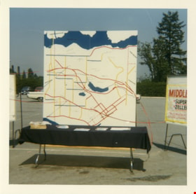
- Photograph of a large map of Burnaby displayed on a table in a parking lot. A poster for "Middlegate" Shopping Centre is displayed to the right.
- Repository
- Burnaby Village Museum
- Collection/Fonds
- Donald Copan collection
- Series
- Copan album series
- Description Level
- Item
- Physical Description
- 1 photograph : col. ; 8.9 x 8.9 cm
- Scope and Content
- Photograph of a large map of Burnaby displayed on a table in a parking lot. A poster for "Middlegate" Shopping Centre is displayed to the right.
- Accession Code
- BV005.54.273
- Access Restriction
- No restrictions
- Reproduction Restriction
- May be restricted by third party rights
- Date
- 1971
- Media Type
- Photograph
- Scan Resolution
- 600
- Scan Date
- July 23, 2020
- Scale
- 100
- Notes
- Title based on contents of photograph
Images


Marine Way and Willard Street
https://search.heritageburnaby.ca/link/archivedescription79912
- Repository
- City of Burnaby Archives
- Date
- November, 1976
- Collection/Fonds
- Burnaby Public Library Contemporary Visual Archive Project
- Description Level
- Item
- Physical Description
- 1 photograph : b&w ; 11 x 16 cm mounted on cardboard
- Scope and Content
- Photograph shows a collection of signboards on the corner of Marine Way and Willard Street.
- Repository
- City of Burnaby Archives
- Date
- November, 1976
- Collection/Fonds
- Burnaby Public Library Contemporary Visual Archive Project
- Physical Description
- 1 photograph : b&w ; 11 x 16 cm mounted on cardboard
- Description Level
- Item
- Record No.
- 556-494
- Access Restriction
- No restrictions
- Reproduction Restriction
- Reproduce for fair dealing purposes only
- Accession Number
- 2013-13
- Scope and Content
- Photograph shows a collection of signboards on the corner of Marine Way and Willard Street.
- Media Type
- Photograph
- Photographer
- Campbell, Peg
- Notes
- Scope note taken directly from BPL photograph description.
- 1 b&w copy negative : 10 x 12.5 cm accompanying
- Geographic Access
- Marine Way
- Willard Street
- Historic Neighbourhood
- Fraser Arm (Historic Neighbourhood)
- Planning Study Area
- Big Bend Area
Images


Maywood Barber Shop
https://search.heritageburnaby.ca/link/archivedescription79179
- Repository
- City of Burnaby Archives
- Date
- October, 1976
- Collection/Fonds
- Burnaby Public Library Contemporary Visual Archive Project
- Description Level
- Item
- Physical Description
- 1 photograph : b&w ; 11 x 16 cm mounted on cardboard
- Scope and Content
- Photograph shows the Maywood Barber Shop at 4386 Imperial Street. The building was built in the 1930s and the baber shop opened in 1963.
- Repository
- City of Burnaby Archives
- Date
- October, 1976
- Collection/Fonds
- Burnaby Public Library Contemporary Visual Archive Project
- Physical Description
- 1 photograph : b&w ; 11 x 16 cm mounted on cardboard
- Description Level
- Item
- Record No.
- 556-192
- Access Restriction
- No restrictions
- Reproduction Restriction
- Reproduce for fair dealing purposes only
- Accession Number
- 2013-13
- Scope and Content
- Photograph shows the Maywood Barber Shop at 4386 Imperial Street. The building was built in the 1930s and the baber shop opened in 1963.
- Names
- Maywood Barber Shop
- Media Type
- Photograph
- Photographer
- Cook, Alan
- Notes
- Scope note taken directly from BPL photograph description.
- 1 b&w copy negative : 10 x 12.5 cm accompanying
- Geographic Access
- Imperial Street
- Street Address
- 4368 Imperial Street
- Historic Neighbourhood
- Alta-Vista (Historic Neighbourhood)
- Planning Study Area
- Sussex-Nelson Area
Images


McKay Barbers
https://search.heritageburnaby.ca/link/archivedescription79177
- Repository
- City of Burnaby Archives
- Date
- September 15, 1976
- Collection/Fonds
- Burnaby Public Library Contemporary Visual Archive Project
- Description Level
- Item
- Physical Description
- 1 photograph : b&w ; 11 x 16 cm mounted on cardboard
- Scope and Content
- Photograph shows signs in the window of McKay Barbers advertising prices for haircuts. The shop, on Kingsway near McKay, was built in the 1920s originally as part of the grocery store next door and was a bakery for a time. At the time of the photograph, it had been a barber shop for 42 years.
- Repository
- City of Burnaby Archives
- Date
- September 15, 1976
- Collection/Fonds
- Burnaby Public Library Contemporary Visual Archive Project
- Physical Description
- 1 photograph : b&w ; 11 x 16 cm mounted on cardboard
- Description Level
- Item
- Record No.
- 556-191
- Access Restriction
- No restrictions
- Reproduction Restriction
- Reproduce for fair dealing purposes only
- Accession Number
- 2013-13
- Scope and Content
- Photograph shows signs in the window of McKay Barbers advertising prices for haircuts. The shop, on Kingsway near McKay, was built in the 1920s originally as part of the grocery store next door and was a bakery for a time. At the time of the photograph, it had been a barber shop for 42 years.
- Names
- McKay Barber Shop
- Media Type
- Photograph
- Photographer
- McCarron, John
- Notes
- Scope note taken directly from BPL photograph description.
- 1 b&w copy negative : 10 x 12.5 cm accompanying
- Geographic Access
- McKay Avenue
- Historic Neighbourhood
- Central Park (Historic Neighbourhood)
- Planning Study Area
- Maywood Area
Images


Mid-City Meats, Burnaby Christian Supply and Tommy's Produce
https://search.heritageburnaby.ca/link/archivedescription79226
- Repository
- City of Burnaby Archives
- Date
- September 15, 1976
- Collection/Fonds
- Burnaby Public Library Contemporary Visual Archive Project
- Description Level
- Item
- Physical Description
- 1 photograph : b&w ; 11 x 16 cm mounted on cardboard
- Scope and Content
- Photograph shows large billboards above Mid-City Meats, Burnaby Christian Supply and Tommy's Produce, located on Kingsway near Cassie Avenue. Burnaby Christian Supply was a music store prior to 1963 and Mid-City Meats was a drug store in the 1920s.
- Repository
- City of Burnaby Archives
- Date
- September 15, 1976
- Collection/Fonds
- Burnaby Public Library Contemporary Visual Archive Project
- Physical Description
- 1 photograph : b&w ; 11 x 16 cm mounted on cardboard
- Description Level
- Item
- Record No.
- 556-209
- Access Restriction
- No restrictions
- Reproduction Restriction
- Reproduce for fair dealing purposes only
- Accession Number
- 2013-13
- Scope and Content
- Photograph shows large billboards above Mid-City Meats, Burnaby Christian Supply and Tommy's Produce, located on Kingsway near Cassie Avenue. Burnaby Christian Supply was a music store prior to 1963 and Mid-City Meats was a drug store in the 1920s.
- Subjects
- Advertising Medium - Signs and Signboards
- Buildings - Commercial - Butcher Shops
- Buildings - Commercial - Grocery Stores
- Media Type
- Photograph
- Photographer
- McCarron, John
- Notes
- Scope note taken directly from BPL photograph description.
- 1 b&w copy negative : 10 x 12.5 cm accompanying
- Geographic Access
- Kingsway
- Cassie Avenue
- Historic Neighbourhood
- Central Park (Historic Neighbourhood)
- Planning Study Area
- Maywood Area
Images


Model of Heritage Village
https://search.heritageburnaby.ca/link/museumdescription13818
- Repository
- Burnaby Village Museum
- Date
- Summer 1971
- Collection/Fonds
- Donald Copan collection
- Description Level
- Item
- Physical Description
- 1 photograph : col. ; 8.9 x 8.9 cm
- Scope and Content
- Photograph of model of Heritage Village with sign on display inside of Lougheed Mall (now Lougheed Town Centre).
- Repository
- Burnaby Village Museum
- Collection/Fonds
- Donald Copan collection
- Series
- Copan album series
- Description Level
- Item
- Physical Description
- 1 photograph : col. ; 8.9 x 8.9 cm
- Scope and Content
- Photograph of model of Heritage Village with sign on display inside of Lougheed Mall (now Lougheed Town Centre).
- Subjects
- Buildings - Commercial - Malls
- Buildings - Civic - Museums
- Advertising Medium - Signs and Signboards
- Accession Code
- BV005.54.619
- Access Restriction
- No restrictions
- Reproduction Restriction
- May be restricted by third party rights
- Date
- Summer 1971
- Media Type
- Photograph
- Scan Resolution
- 600
- Scan Date
- 18-Aug-2020
- Scale
- 100
- Notes
- Title based on contents of photograph
Images


Nature Trail Sign
https://search.heritageburnaby.ca/link/archivedescription79889
- Repository
- City of Burnaby Archives
- Date
- September 23, 1976
- Collection/Fonds
- Burnaby Public Library Contemporary Visual Archive Project
- Description Level
- Item
- Physical Description
- 1 photograph : b&w ; 11 x 16 cm mounted on cardboard
- Scope and Content
- Photograph shows a sign commemorating the creation of a nature trail at Burnaby Lake. The trail was developed by a Local Initiatives Project in 1973.
- Repository
- City of Burnaby Archives
- Date
- September 23, 1976
- Collection/Fonds
- Burnaby Public Library Contemporary Visual Archive Project
- Physical Description
- 1 photograph : b&w ; 11 x 16 cm mounted on cardboard
- Description Level
- Item
- Record No.
- 556-490
- Access Restriction
- No restrictions
- Reproduction Restriction
- Reproduce for fair dealing purposes only
- Accession Number
- 2013-13
- Scope and Content
- Photograph shows a sign commemorating the creation of a nature trail at Burnaby Lake. The trail was developed by a Local Initiatives Project in 1973.
- Media Type
- Photograph
- Photographer
- Norton, Paul
- Notes
- Scope note taken directly from BPL photograph description.
- 1 b&w copy negative : 10 x 12.5 cm accompanying
- Geographic Access
- Burnaby Lake
- Historic Neighbourhood
- Burnaby Lake (Historic Neighbourhood)
- Planning Study Area
- Burnaby Lake Area
Images


Nordic Centre
https://search.heritageburnaby.ca/link/archivedescription79734
- Repository
- City of Burnaby Archives
- Date
- November 1, 1976
- Collection/Fonds
- Burnaby Public Library Contemporary Visual Archive Project
- Description Level
- Item
- Physical Description
- 1 photograph : b&w ; 11 x 16 cm mounted on cardboard
- Scope and Content
- Photograph shows the Nordic Centre, located on 6th Street on the corner of 12th Avenue. A billboard advertising its services is attached to the side of the building. A few months after this photo was taken, the Nordic Centre was torn down.
- Repository
- City of Burnaby Archives
- Date
- November 1, 1976
- Collection/Fonds
- Burnaby Public Library Contemporary Visual Archive Project
- Physical Description
- 1 photograph : b&w ; 11 x 16 cm mounted on cardboard
- Description Level
- Item
- Record No.
- 556-407
- Access Restriction
- No restrictions
- Reproduction Restriction
- Reproduce for fair dealing purposes only
- Accession Number
- 2013-13
- Scope and Content
- Photograph shows the Nordic Centre, located on 6th Street on the corner of 12th Avenue. A billboard advertising its services is attached to the side of the building. A few months after this photo was taken, the Nordic Centre was torn down.
- Names
- Nordic Centre
- Media Type
- Photograph
- Notes
- Scope note taken directly from BPL photograph description.
- 1 b&w copy negative : 10 x 12.5 cm accompanying
- Photographers identified by surnames only: Carr and Vardeman
- Geographic Access
- 6th Street
- 12th Avenue
- Historic Neighbourhood
- East Burnaby (Historic Neighbourhood)
- Planning Study Area
- Second Street Area
Images


Old Orchard Shopping Centre
https://search.heritageburnaby.ca/link/archivedescription93603
- Repository
- City of Burnaby Archives
- Date
- October 9, 1977
- Collection/Fonds
- Burnaby Public Library Contemporary Visual Archive Project
- Description Level
- Item
- Physical Description
- 1 photograph : b&w ; 12.5 x 17.5 cm
- Scope and Content
- Photograph of the Old Orchard Shopping Centre, located at Kingsway and Willingdon. The photograph is taken from across the road, facing northwest, and focuses on the shopping centre sign. The other stores' signs, including Shoppers Drug Mart and Autoplan, and a high-rise apartment building are visi…
- Repository
- City of Burnaby Archives
- Date
- October 9, 1977
- Collection/Fonds
- Burnaby Public Library Contemporary Visual Archive Project
- Physical Description
- 1 photograph : b&w ; 12.5 x 17.5 cm
- Description Level
- Item
- Record No.
- 556-560
- Access Restriction
- No restrictions
- Reproduction Restriction
- Reproduce for fair dealing purposes only
- Accession Number
- 2017-57
- Scope and Content
- Photograph of the Old Orchard Shopping Centre, located at Kingsway and Willingdon. The photograph is taken from across the road, facing northwest, and focuses on the shopping centre sign. The other stores' signs, including Shoppers Drug Mart and Autoplan, and a high-rise apartment building are visible in the background.
- Subjects
- Buildings - Commercial - Malls
- Advertising Medium - Signs and Signboards
- Buildings - Residential - Apartments
- Media Type
- Photograph
- Photographer
- Chapman, Fred
- Notes
- Title taken from project information form
- Accompanied by a project information form and 1 photograph (b&w negative ; 9.5 x 12.5 cm)
- BPL no. 4
- Geographic Access
- Kingsway
- Street Address
- 4469 Kingsway
- Historic Neighbourhood
- Central Park (Historic Neighbourhood)
- Planning Study Area
- Maywood Area
Images
